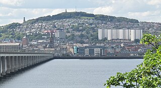
Dundee is the fourth-largest city in Scotland. The mid-year population estimate for 2016 was 148,210, giving Dundee a population density of 2,478/km2 or 6,420/sq mi, the second-highest in Scotland. It lies within the eastern central Lowlands on the north bank of the Firth of Tay, which feeds into the North Sea. Under the name of Dundee City, it forms one of the 32 council areas used for local government in Scotland. Within the boundaries of the historic county of Angus, the city developed into a burgh in the late 12th century and established itself as an important east coast trading port. Rapid expansion was brought on by the Industrial Revolution, particularly in the 19th century when Dundee was the centre of the global jute industry. This, along with its other major industries, gave Dundee its epithet as the city of "jute, jam and journalism".

The Forth Road Bridge is a suspension bridge in east central Scotland. The bridge opened in 1964 and at the time was the longest suspension bridge in the world outside the United States. The bridge spans the Firth of Forth, connecting Edinburgh, at South Queensferry, to Fife, at North Queensferry. It replaced a centuries-old ferry service to carry vehicular traffic, cyclists and pedestrians across the Forth; railway crossings are made by the nearby Forth Bridge, opened in 1890.

The Caledonian Canal connects the Scottish east coast at Inverness with the west coast at Corpach near Fort William in Scotland. The canal was constructed in the early nineteenth century by Scottish engineer Thomas Telford.

Cape Wrath is a cape in the Durness parish of the county of Sutherland in the Highlands of Scotland. It is the most north-westerly point in Great Britain.

Carbisdale Castle was built in 1907 for the Duchess of Sutherland on a hill across the Kyle of Sutherland from Invershin in the Scottish Highlands. Until 2011 it was used as a youth hostel, operated by the Scottish Youth Hostels Association. The castle is situated north of Culrain, and around 5 kilometres (3.1 mi) north-west of Bonar Bridge. It lies within the civil parish of Kincardine and Community council of Ardgay and District.

Helmsdale is a village on the east coast of Sutherland, in the Highland council area of Scotland. The modern village was planned in 1814 to resettle communities that had been removed from the surrounding straths as part of the Highland Clearances.

Carnoustie is a town and former police burgh in the council area of Angus, Scotland. It is at the mouth of the Barry Burn on the North Sea coast. In the 2011 census, Carnoustie had a population of 11,394, making it the fourth-largest town in Angus. The town was founded in the late 18th century, and grew rapidly throughout the 19th century due to the growth of the local textile industry. It was popular as a tourist resort from the early Victorian era up to the latter half of the 20th century, due to its seaside location, and is best known for the Carnoustie Golf Links course that often hosts the Open Championship.

Ellon is a town in Aberdeenshire, Scotland, approximately 16 miles north of Aberdeen, lying on the River Ythan, which has one of the few undeveloped river estuaries on the eastern coast of Scotland. It is in the ancient region of Formartine. Its name is believed to derive from the Gaelic term Eilean, an island, on account of the presence of an island in the River Ythan, which offered a convenient fording point. In 1707 it was made a burgh of barony for the Earl of Buchan. It is home to a unique collection of ancient yew trees.

Bonar Bridge is a village on the north bank of the Kyle of Sutherland to the west and the Dornoch Firth to the east in the Parish of Creich in the Highland council area of Scotland.
Penpont is a village about 2 miles (3 km) west of Thornhill in Dumfriesshire, in the Dumfries and Galloway region of Scotland. It is near the confluence of the Shinnel Water and Scaur Water rivers in the foothills of the Southern Uplands. It has a population of about 400 people.

Dunrobin Castle is a stately home in Sutherland, in the Highland area of Scotland, as well as the family seat of the Earl of Sutherland, Chief of the Clan Sutherland. It is located one mile north of Golspie and approximately five miles south of Brora, overlooking the Dornoch Firth.

The River Shin is a river in the Scottish North West Highlands.

Cape Wrath Lighthouse at Cape Wrath was built in 1828 by Robert Stevenson and was manned until 1998, when it was converted to automatic operation by the Northern Lighthouse Board. It is located at the most North-Westerly point on the British mainland, in the traditional county of Sutherland within Highland Region. Durness is the closest village, 10 miles (16 km) to the south-east with Inverness around 120 miles (190 km) to the south.

Mar Lodge is a sporting lodge 5 miles to the west of Braemar and the principal building on the Mar Lodge Estate in Aberdeenshire, Scotland. It was built in 1895, replacing an earlier building, by Alexander Duff, 1st Duke of Fife.
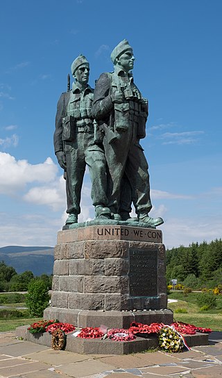
The Commando Memorial is a Category A listed monument in Lochaber, Scotland, dedicated to the men of the original British Commando Forces raised during World War II. Situated around a mile from Spean Bridge, it overlooks the training areas of the Commando Training Depot established in 1942 at Achnacarry Castle. Unveiled in 1952 by the Queen Mother, it is one of Scotland's best-known monuments, both as a war memorial and as a tourist attraction offering views of Ben Nevis and Aonach Mòr.

George V Bridge is a three-arched road bridge over the River Clyde in the city centre of Glasgow, Scotland, named after King George V.

Bridge of Cally is a small village in Kirkmichael parish, Perth and Kinross, Scotland. It sits at the junction of three glens, Glenshee, Strathardle and Glenericht and is centred round the bridge over the River Ardle 200 m (220 yd) before it joins the Black Water to form the River Ericht. The A93 road from Perth to Aberdeen crosses the bridge where it forms a junction with the A924 road to Kirkmichael and Pitlochry. The village is on the Cateran Trail long-distance path, and is popular in winter as it is near the Glen Shee skiing area.
Laxford is a remote area in the far Northwest Highlands of Scotland around the River Laxford which runs northwest from Loch Stack to Laxford Bay. This bay is an inlet of Loch Laxford, a sea loch and Special Area of Conservation. The river is well known for its salmon fly fishing, indeed the name "Laxford" derives from the Norse for "salmon fjord". The area is important geologically, being a region of shear in the Moine Thrust. A road bridge, Laxford Bridge, crosses the river adjacent to the A838 and A894 roads, the road junction making the spot well known to tourists. Laxford is in Sutherland, in the Highland council area of Scotland; Scourie, 12 kilometres away, is the nearest village. The area forms part of the North West Sutherland National Scenic Area, one of 40 such areas in Scotland, which are defined so as to identify areas of exceptional scenery and to ensure its protection by restricting certain forms of development.

Cartland Bridge is a road bridge on the A73 north-west of Lanark, South Lanarkshire which spans the Mouse Water, a tributary of the River Clyde. The three-span bridge was built in 1822, to designs by the engineer Thomas Telford. It is notable for being the highest bridge over inland water in Scotland. It is a category B listed building.

Erskine Ferry sailed across the River Clyde from Erskine to Old Kilpatrick. The ferry was also referred to as East Ferry of Erskine as there was another ferry to Dumbarton a few miles down river, known as West Ferry. It is reputed to be the oldest ferry crossing of the Clyde. The crossing was part of the A740 route from Paisley to Old Kilpatrick. It was established in 1777 and replaced by the Erskine Bridge in 1971.

