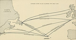
TAT-1 was the first submarine transatlantic telephone cable system. It was laid between Oban, Scotland and Clarenville, Newfoundland. Two cables were laid between 1955 and 1956 with one cable for each direction. It was inaugurated on September 25, 1956. The cable was able to carry 35 simultaneous telephone calls. A 36th channel was used to carry up to 22 telegraph lines.

Telecom Bretagne was a French grande école of engineering, and a research centre providing training in information technologies and telecommunications. In 2017, it merged with École des mines de Nantes to form IMT Atlantique.

Valentia Island is one of Ireland's most westerly points. It lies off the Iveragh Peninsula in the southwest of County Kerry. It is linked to the mainland by the Maurice O'Neill Memorial Bridge at Portmagee. A car ferry also departs from Reenard Point to Knightstown, the island's main settlement, from April to October. Another, smaller village named Chapeltown sits at roughly the midpoint of the island, three kilometres from the bridge. Valentia Island's permanent population is 665. It is about 11 kilometres long by almost three kilometres wide, making it the third-biggest island off the Irish coast.

Oxwich Bay is a bay on the south of the Gower Peninsula, Wales.

Heart's Content is an incorporated town in Trinity Bay on the Bay de Verde Peninsula of Newfoundland and Labrador, Canada.

The Raz de Sein is a stretch of water located between the Isle of Sein and the Pointe du Raz in Finistère located in the Brittany region of France.
Deolen Village IN Indian district of Karauli (Rajasthan)
Orleans Cove is the cove in the town of Orleans, Massachusetts
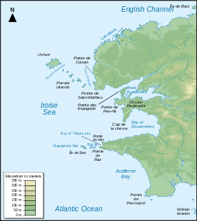
Iroise or the Iroise Sea is the part of the Atlantic Ocean which stretches from the Ile de Sein to Ushant off the coast of Brittany in north-western France. It is contained within the Celtic Sea, bordering the remainder of the Celtic Sea to the north and west, and the Bay of Biscay to the south. It is one of the most dangerous seas in Europe for sea-going vessels. In winter, there are often violent storms with huge waves. It is also one of the richest areas for marine life and was designated as one of UNESCO's biosphere reserves in 1988 and as France's first marine park in October 2007.

The University of Western Brittany is a French university, located in Brest, in the Academy of Rennes. On a national scale, in terms of graduate employability, the university oscillates between 18th and 53rd out of 69 universities depending on fields of study. Overall, the University is ranked 12th out of 76 universities in France.
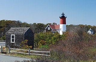
The French Cable Hut is a historic building in Cape Cod National Seashore, near the Nauset Beach Light in Eastham, Massachusetts. Built in 1891, the hut formed a linkage point in the transatlantic telegraph cable of the French Cable Company connecting the cable, where it came ashore near the present site to its main station in Orleans. After the cable was abandoned in 1932, the hut was adapted for residential use. It has since been restored to its turn-of-the-century appearance by the National Park Service. The building was listed on the National Register of Historic Places in 1976.

The Goulet de Brest is a 3-km-long strait linking the roadstead of Brest to the Atlantic Ocean. Only 1.8 km wide, the goulet is situated between the Pointe du Petit Minou and the Pointe du Portzic to the north and the îlot des Capucins and the Pointe des Espagnols to the south.

The Petit Minou Lighthouse is a lighthouse in the roadstead of Brest, standing in front of the Fort du Petit Minou, in the commune of Plouzané. By aligning it with the Phare du Portzic, it shows the safe route to follow for ships to enter the roadstead. It also has a red signal that indicates a dangerous sector around the plateau of les Fillettes, one of the submerged rocks in the Goulet de Brest — sailors remember this by using the mnemonic "Le Minou rougit quand il couvre les Fillettes".

The Portzic Lighthouse is situated on the north-eastern extremity of the Goulet de Brest and is the nearest lighthouse to the town of Brest. It is a 35 metres (115 ft) tall octagonal tower. On the seaward side of the bottleneck entrance to the goulet, the lighthouse faces the Pointe des Espagnols.

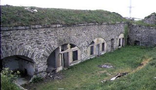
Built between 1694 and 1697, the Fort du Petit Minou was a fort built in the commune of Plouzané in France to defend the goulet de Brest. It consists of 6m high masonry bastions, surrounded by a 3m deep and 9.5m wide moat.
The military remains known as Fort de Toulbroc'h form part of the defences along the goulet de Brest in France, in the commune of Locmaria-Plouzané. They are accessible via coastal path GR34 to the pointe du Grand Minou.

The Fort de Portzic was built near the town of Brest by Vauban between 1693 and 1699 as part of the defences of the goulet de Brest. It faces the pointe des Espagnols and was improved and enlarged over time, since it formed the town's last and innermost defence. The buildings on the site remain in military use. Nearby is the lighthouse Phare du Portzic.

The Pointe des Espagnols is the north-east extremity of the Roscanvel peninsula, an outgrowth of the Crozon peninsula closing off the roadstead of Brest. It also marks the south-east limit of the goulet de Brest.

The Pointe du Toulinguet is a promontory at the end of the Crozon peninsula in the commune of Camaret-sur-Mer in France.
