
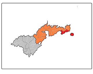
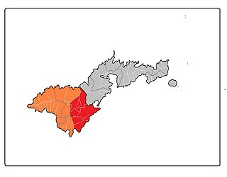
Leasina County is a county in the Western District in American Samoa. [1] [2] [3]
Leasina County is a county in the Western District in American Samoa. [1] [2] [3]
Leasina County was first recorded beginning with the 1912 special census. Regular decennial censuses were taken beginning in 1920. [4]
| Year | Pop. | ±% |
|---|---|---|
| 1912 | 241 | — |
| 1920 | 290 | +20.3% |
| 1930 | 272 | −6.2% |
| 1940 | 335 | +23.2% |
| 1950 | 447 | +33.4% |
| 1960 | 571 | +27.7% |
| 1970 | 637 | +11.6% |
| 1980 | 620 | −2.7% |
| 1990 | 1,470 | +137.1% |
| 2000 | 1,739 | +18.3% |
| 2010 | 1,807 | +3.9% |
| U.S. Decennial Census [5] | ||

Richland County is a county in the U.S. state of Montana. As of the 2020 census, the population was 11,491. Its county seat is Sidney.

Ionia County is a county located in the U.S. state of Michigan. As of the 2020 census, the population was 66,804. The county seat is Ionia. The Ionia County Courthouse was designed by Claire Allen, a prominent southern Michigan architect.
Cass County is a county located in the U.S. state of Illinois. As of the 2020 United States Census, the population was 13,042. Its county seat is Virginia. It is the home of the Jim Edgar Panther Creek State Fish and Wildlife Area.

Long County is a county located in the U.S. state of Georgia. The county seat is Ludowici. Long County is part of the Hinesville-Fort Stewart Metropolitan Statistical Area. The constitutional amendment to create the county was proposed August 14, 1920, and ratified November 2, 1920. The county is named after Crawford Long (1815–1878), American surgeon and pharmacist, first to use diethyl ether as an anaesthetic.

The Eastern District is one of the primary districts of American Samoa. It consists of the eastern portion of Tutuila, American Samoa's largest island, plus the island of Aunu'u. The district has a land area of 67.027 km2 and a 2010 census population of 23,030. It contains 34 villages plus a portion of Nu'uuli village. Among these are Pago Pago, Fagatogo, and Utulei.
The Western District is one of the three primary divisions of American Samoa. It consists of the western portion of Tutuila Island. It has a land area of 74.781 km2 and contains 29 villages plus a part of Nu'uuli village. Among these is the largest village of American Samoa, Tafuna, at its eastern end. The district's total population as of the 2010 census was 31,329.
The Manuʻa District is one of the three primary administrative divisions of American Samoa. The district comprises the Manuʻa Islands, which are located approximately 61 miles (98 km) east of the main island, Tutuila. The Manuʻa District is considered to be a county-equivalent by the U.S. Census Bureau.

Itūʻau County is a county in the Eastern District in American Samoa. The official name is Itūʻau ma Nofo, however, it is commonly known as just Itūʻau. It is divided into northern and southern parts by the highest part of the Tutuila's central mountain range. It is peculiar in that it had no county chief. In Nu'uuli in the south, power was divided between village high chief Savusa and the Four Chiefly Houses of the Soliai, Tago, Levu, and Alega. In Fagasā in the north, leadership was shared by the Tupuola and the Alo. The physical division of the county by mountains combined with the lack of a high chief made the county a battleground (itu'au) in ancient times.
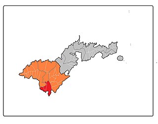
Saʻole County is a county in the Eastern District in American Samoa. The county consists of Aunu'u Island together with its foothold upon Tutuila Island, Ālōfau and Āmouli.
Suʻa County is a county in the Eastern District in American Samoa. Su'a County contains the villages of Afono, Fagaitua, Falefa, Lauli'i, Masefau, Masausi and Sailele. The county had a population of 3,323 as of the 2010 U.S. Census. According to the Constitution of American Samoa, Sua County is represented by two senatorial seats in the American Samoa Senate.
Vaifanua County is a county in the Eastern District in American Samoa.
Lealataua County is a county in the Western District in American Samoa.
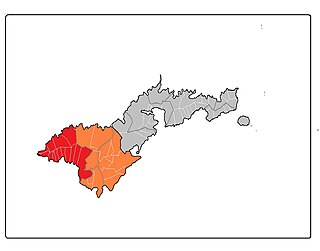
Tuālā-tai County is one of the five counties that make up the Western District of American Samoa.
Tuālāuta County is a county in the Western District in American Samoa. It is the largest and also the most populated county in American Samoa. The county is represented by two seats in the Senate and two seats in House of Representatives in the American Samoa Legislature. 'Ili'ili is the principal place in Tualauta County, a county which consists of 'Ili'ili, Pava'ia'i, Mapusaga, Faleniu, Mesepa, Malae'imi, Tafuna, and Vaitogi.
Faleāsao County is a county in the Manu'a District in American Samoa. The county is contiguous with its only village, also named Faleasao.
Fitiʻuta County is a county in the Manu'a District in American Samoa.
Ofu County is a county in the Manu'a District in American Samoa. It was the result of the subdivision of the prior Luanuu County in two, with the other newly created county being Olosega, first reported on the 1930 U.S. Census. It is now contiguous with its only village, Ofu.
Olosega County is a county in the Manu'a District in American Samoa. It was the result of the subdivision of the prior Luanuu County in two, with the other newly created county being Ofu, first reported on the 1930 U.S. Census. It contains the two villages of Olosega and Sili.
Taʻū County is a county in the Manu'a District in American Samoa.
Luanuu County is a former county in the Manu'a District in American Samoa. It reported on the 1912 special census and the 1920 U.S. Census. It was subdivided into the present Ofu and Olosega Counties in 1930. It contained the villages of Ofu, Olosega and Sili.
14°19′11″S170°46′12″W / 14.31972°S 170.77000°W
| | This American Samoa location article is a stub. You can help Wikipedia by expanding it. |