Lealataua County is a county in the Western District in American Samoa. [1] [2] [3]
Year | Pop. | ±% |
---|---|---|
1912 | 1,163 | — |
1920 | 1,134 | −2.5% |
1930 | 1,256 | +10.8% |
1940 | 1,625 | +29.4% |
1950 | 2,201 | +35.4% |
1960 | 2,393 | +8.7% |
1970 | 3,145 | +31.4% |
1980 | 3,581 | +13.9% |
1990 | 5,106 | +42.6% |
2000 | 5,684 | +11.3% |
2010 | 5,103 | −10.2% |
2020 | 4,293 | −15.9% |
U.S. Decennial Census [4] |
Lealataua County was first recorded beginning with the 1912 special census. Regular decennial censuses were taken beginning in 1920. [5]
The Eastern District is one of the primary districts of American Samoa. It consists of the eastern portion of Tutuila, American Samoa's largest island, plus the island of Aunu'u. The district has a land area of 67.027 km2 (25.879 sq mi) and a 2010 census population of 23,030. It contains 34 villages plus a portion of Nuʻuuli village. Among these are Pago Pago, Fagatogo, and Utulei.
The Western District is one of the three primary divisions of American Samoa. It consists of the western portion of Tutuila Island. It has a land area of 74.781 km2 (28.873 sq mi) and contains 29 villages plus a part of Nuʻuuli village. Among these is the largest village of American Samoa, Tafuna, at its eastern end. The district's total population as of the 2010 census was 31,329.
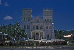
Leone is the second-largest city on Tutuila Island's west coast. The village is on the south-west coast of Tutuila Island, American Samoa. Leone was the ancient capital of Tutuila Island. Leone was also where the Samoan Islands’ first missionary, John Williams, visited on October 18, 1832. A monument in honor of Williams has been erected in front of Zion Church. Its large church was the first to be built in American Samoa. It has three towers, a carved ceiling and stained glass. Until steamships were invented, Leone was the preferred anchorage of sailing ships which did not risk entering Pago Pago Harbor. Much early contact between Samoans and Europeans took place in Leone.
Nuʻuuli is a village on the central east coast of Tutuila Island, American Samoa. It is located on a peninsula several miles up from Pago Pago International Airport. Nuʻuuli is located between Pago Pago International Airport and Coconut Point. It is a shopping district which is home to stores, groceries and many more shops.
The following outline is provided as an overview of and topical guide to American Samoa:
Afao is a village in southwest Tutuila Island, American Samoa. It is located on the island's short southwestern coast, between 'Amanave and Leone, to the southwest of Pago Pago. It includes the settlement of Atauloma. Afao is home to two places listed on the U.S. National Register of Historic Places: Afao Beach Site and Atauloma Girls School.
ʻAmanave is a village on the coast of Tutuila Island, American Samoa. It is located close to the island's western tip, Cape Taputapu, and to the south of the village of Poloa. It is located in Lealataua County.
Amaluia is a village on the southwest coast of Tutuila Island, American Samoa. It is located between Leone and 'Amanave. It is located in Lealataua County.
Asili is a village on the southwest coast of Tutuila Island, American Samoa. It is located between Leone and 'Amanave. It is located in Lealataua County.
Faʻilolo is a village in the far west of Tutuila Island, American Samoa. It is located just south of ʻAmanave, close to the island's westernmost point, Cape Taputapu. It is located in Lealataua County.
Cape Taputapu is the name of a cape located in the Western District of American Samoa. Located in Tutuila, it is the island's westernmost point. The cape was designated as a National Natural Landmark in 1972.
Maʻopūtasi County is located in the Eastern District of Tutuila Island in American Samoa. Maʻopūtasi County comprises the capital of Pago Pago and its harbor, as well as surrounding villages. It was home to 11,695 residents as of 2000. Maʻopūtasi County is 6.69 square miles (17.3 km2) The county has a 7.42-mile (11.94 km) shoreline which includes Pago Pago Bay.
Itūʻau County is a county in the Eastern District in American Samoa. The official name is Itūʻau ma Nofo, however, it is commonly known as just Itūʻau. It is divided into northern and southern parts by the highest part of the Tutuila's central mountain range. It is peculiar in that it had no county chief. In Nuʻuuli in the south, power was divided between village high chief Savusa and the Four Chiefly Houses of the Soliai, Tago, Levu, and Alega. In Fagasā in the north, leadership was shared by the Tupuola and the Alo. The physical division of the county by mountains combined with the lack of a high chief made the county a battleground (itu'au) in ancient times.
Saʻole County is a county in the Eastern District in American Samoa. The county consists of Aunu'u Island together with its foothold upon Tutuila Island, Ālōfau and Āmouli.
Suʻa County is a county in the Eastern District in American Samoa. Su'a County contains the villages of Afono, Fagaitua, Falefa, Lauli'i, Masefau, Masausi and Sailele. The county had a population of 3,323 as of the 2010 U.S. Census. According to the Constitution of American Samoa, Sua County is represented by two senatorial seats in the American Samoa Senate.
Vaifanua County is a county in the Eastern District in American Samoa.
Leasina County is a county in the Western District in American Samoa. The name of the county, Leasina, is derived from the Samoan language and translates into English as “White".
Tuālā-tai County is one of the five counties that make up the Western District of American Samoa.
Tuālāuta County is a county in the Western District in American Samoa. It is the largest and also the most populated county in American Samoa. The county is represented by two seats in the Senate and two seats in House of Representatives in the American Samoa Legislature. 'Ili'ili is the principal place in Tualauta County, a county which consists of 'Ili'ili, Pava'ia'i, Mapusaga, Faleniu, Mesepa, Malae'imi, Tafuna, and Vaitogi.
Fitiʻuta County is a county in the Manu'a District in American Samoa.
14°20′38″S170°47′06″W / 14.34389°S 170.78500°W