
Arbor Day is a secular day of observance in which individuals and groups are encouraged to plant trees. Today, many countries observe such a holiday. Though usually observed in the spring, the date varies, depending on climate and suitable planting season.

The first memorials to the victims of the September 11 attacks in 2001 began to take shape online, as hundreds of webmasters posted their own thoughts, links to the Red Cross and other rescue agencies, photos, and eyewitness accounts. Numerous online September 11 memorials began appearing a few hours after the attacks, although many of these memorials were only temporary. Around the world, U.S. embassies and consulates became makeshift memorials as people came out to pay their respects.
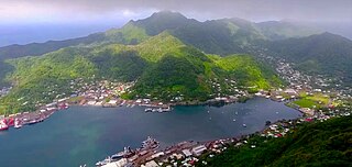
Pago Pago is the capital of American Samoa. It is in Maoputasi County on Tutuila, which is American Samoa's main island.
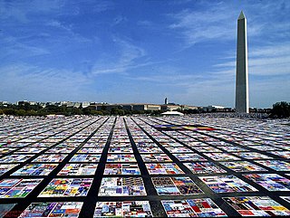
The NAMES Project AIDS Memorial Quilt, often abbreviated to AIDS Memorial Quilt or AIDS Quilt, is a memorial to celebrate the lives of people who have died of AIDS-related causes. Weighing an estimated 54 tons, it is the largest piece of community folk art in the world as of 2020. It was conceived in 1985, during the early years of the AIDS pandemic, when social stigma prevented many AIDS victims from receiving funerals. It has been displayed on the Mall in Washington, D.C., several times. In 2020, it returned to the AIDS Memorial in San Francisco, and can also be seen virtually.

The Samoan Islands are an archipelago covering 3,030 km2 (1,170 sq mi) in the central South Pacific, forming part of Polynesia and of the wider region of Oceania. Administratively, the archipelago comprises all of the Independent State of Samoa and most of American Samoa. The land masses of the two Samoan jurisdictions are separated by 64 km (40 mi) of ocean at their closest points.
Poloa is a village in American Samoa. It is located at the west side of Tutuila in the Alataua District. The village has 193 residents in 2010. The main denominations in the area are Methodist and Christian. Poloa has one elementary school. It is located in Lealataua County.

Pago Pago International Airport, also known as Tafuna Airport, is a public airport located 7 miles (11.3 km) southwest of the central business district of Pago Pago, in the village and plains of Tafuna on the island of Tutuila in American Samoa, an unincorporated territory of the United States.

Leone is the second-largest city on Tutuila Island's west coast. The village is on the south-west coast of Tutuila Island, American Samoa. Leone was the ancient capital of Tutuila Island. Leone was also where the Samoan Islands’ first missionary, John Williams, visited on October 18, 1832. A monument in honor of Williams has been erected in front of Zion Church. Its large church was the first to be built in American Samoa. It has three towers, a carved ceiling and stained glass. Until steamships were invented, Leone was the preferred anchorage of sailing ships which did not risk entering Pago Pago Harbor. Much early contact between Samoans and Europeans took place in Leone.
The 2009 Samoa earthquake and tsunami took place on 29 September 2009 in the southern Pacific Ocean adjacent to the Kermadec-Tonga subduction zone. The submarine earthquake occurred in an extensional environment and had a moment magnitude of 8.1 and a maximum Mercalli intensity of VI (Strong). It was the largest earthquake of 2009. The earthquake initiated with a normal-faulting event with a magnitude of 8.1. Within two minutes of the earthquake rupture, two large magnitude 7.8 earthquakes occurred on the subduction zone interface. The two magnitude 7.8 earthquakes had a combined magnitude equivalent to 8.0. The event can be considered a doublet earthquake.

The Beverly Hills 9/11 Memorial Garden is a memorial space in honor of the victims of the September 11 attacks in Beverly Hills, California at the corner of North Rexford Drive and South Santa Monica Boulevard/Burton Way. Dedicated on September 11, 2011, exactly ten years after the attack, it is centered on a 30-foot bent steel beam salvaged from the wreckage of the World Trade Center. It was entirely funded by private donors. It forms part of the grounds of the Beverly Hills Fire Department.

Pago Park Soccer Stadium is a soccer stadium in Pago Pago, American Samoa. The capacity is 2,000.

The Cenotaph in the southern New Zealand city of Dunedin stands in the centre of Queen's Gardens, close to the city centre. It is the city's main war memorial.
The Transgender Memorial Garden is a memorial to transgender people killed by anti-LGBTQ violence. It is located at 2800 Wyoming Street in the Benton Park West neighborhood of St. Louis, Missouri.
Andra Samoa is an American Samoan chief executive and environmentalist. She is also involved as a community organizer in Leone and works on several projects to restore coastal environmental areas. She was one of two women serving in the American Samoa Fono in 2019. She lost reelection in 2022.

The InternationalTree of Peace is an international initiative that originated in Slovakia. The project, created on the occasion of the 100th anniversary of the end of World War I, was initiated by landscape architect Marek Sobola from Žilina, Slovakia. The main goal of the project is to promote a message of peace by planting a Tree of Peace on every continent. The project is claimed to aim at planting trees around the globe to draw awareness to the global environmental issue and to enhance the solidarity of the humankind. The initiative, with the support of the Ministry of Foreign and European Affairs of the Slovak Republic, is implemented by Slovak NGO Servare et Manere which has a Special Consultative Status within the Economic and Social Council of the United Nations. The project's motto is "Let's make love the lifeblood of this world".
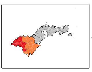
Lealataua County is a county in the Western District in American Samoa.
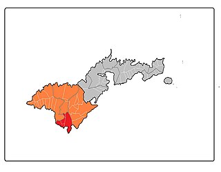
Tuālā-tai County is one of the five counties that make up the Western District of American Samoa.
Ottoville is a subdivision or district within the village of Tafuna, American Samoa.
Satala is one of Pago Pago’s constituent villages and is located in Pago Pago Bay on Tutuila Island. Satala is in Maoputasi County in the Eastern District of the island. It is home to the historic Satala Cemetery, which is listed on the U.S. National Register of Historic Places, and the government-owned Ronald Reagan Marina Railway Shipyard.
Lauliʻi is a village on the eastern side of Tutuila Island in American Samoa. It is located in Sua County. Entering the village of Lauliʻi, one has to climb a small hill where a lighthouse is located. The village's rugby club is named after the lighthouse — Moli ole Ava. It is one of the most successful and oldest clubs in the territory. Many well-known players have emerged from Lauliʻi, such as Vui Eli Tagaloa, the current coach, Ropeti Taula, and others. The village is divided into two sections: Lauliʻituai and Lauliʻifou .As of Late 2020 there are 6 Christian Worship Churches in Lauliʻi. The Methodist, The Catholic, The London Missionary Society, Church, Assembly of God, Church of Christ Latter Day Saints Lauliʻi Ward, Saint John's Episcopal Church. Breakers Point Naval Guns, which is listed on the U.S. National Register of Historic Places is located at Tafananai near Lauliʻifou.
