Lee Meadows Swamp

Last updated

The Lee Meadows Swamp is a swamp that originally covered 500-acre (2.0 km2) with low woodlands surrounding it. It is located in the southeastern section of Parsippany-Troy Hills Township and the western section of Hanover Township, in Morris County, New Jersey, United States. [1] Due to the construction of office buildings and roads in the 1980s, the swamp has been reduced in size.

Swamp A forested wetland

A swamp is a wetland that is forested. Many swamps occur along large rivers where they are critically dependent upon natural water level fluctuations. Other swamps occur on the shores of large lakes. Some swamps have hammocks, or dry-land protrusions, covered by aquatic vegetation, or vegetation that tolerates periodic inundation or soil saturation. The two main types of swamp are "true" or swamp forests and "transitional" or shrub swamps. In the boreal regions of Canada, the word swamp is colloquially used for what is more correctly termed a bog, fen, or muskeg. The water of a swamp may be fresh water, brackish water or seawater. Some of the world's largest swamps are found along major rivers such as the Amazon, the Mississippi, and the Congo.

Hanover Township, New Jersey Township in New Jersey, United States

Hanover Township is a township in Morris County, New Jersey, United States. At the 2010 United States Census, the township's population was 13,712, reflecting an increase of 814 (+6.3%) from the 12,898 counted in the 2000 Census, which had in turn increased by 1,360 (+11.8%) from the 11,538 counted in the 1990 Census. The township comprises the unincorporated communities of Whippany and Cedar Knolls.

Morris County, New Jersey County in New Jersey

Morris County is a county located in the U.S. state of New Jersey, about 25 mi (40 km) west of New York City. According to the 2010 United States Census, the population was 492,276, up from the 470,212 at the 2000 Census, As of the 2017 Census estimate, the county's population was 499,693, making it the state's 10th-most populous county, and marking a 1.5% increase from 2010. The county is part of the New York Metropolitan Area, and its county seat is Morristown. The most populous place was Parsippany-Troy Hills Township, with 53,238 residents at the time of the 2010 Census, while Rockaway Township covered 45.55 square miles (118.0 km2), the largest total area of any municipality.

Contents

Geology

During the late Triassic and early Jurassic periods, when the North American plate separated from the African plate, an aborted rift system was created. The resulting rift valley, known as the Newark Basin, was filled with alternating layers of red bed sediment and flood basalts. Over millions of years, the rift valley was faulted, tilted, and eroded, until the edges of the hard flood basalt layers formed ridges. Prior to 20,000 years before the present, an ancestral Passaic River flowed through a gap in these ridges. This changed when the Wisconsin Glacier, a massive continental ice sheet which formed during the last ice age, advanced on the region and permanently plugged the gap with glacial rubble. As the glacier eventually melted back, water pooled behind the ridges (known today as the Watchung Mountains), forming Glacial Lake Passaic. After thousands of years, the lake drained leaving behind many swamps, including Lee Meadows.

The Triassic is a geologic period and system which spans 50.6 million years from the end of the Permian Period 251.9 million years ago (Mya), to the beginning of the Jurassic Period 201.3 Mya. The Triassic is the first and shortest period of the Mesozoic Era. Both the start and end of the period are marked by major extinction events.

The Jurassic period was a geologic period and system that spanned 56 million years from the end of the Triassic Period 201.3 million years ago (Mya) to the beginning of the Cretaceous Period 145 Mya. The Jurassic constitutes the middle period of the Mesozoic Era, also known as the Age of Reptiles. The start of the period was marked by the major Triassic–Jurassic extinction event. Two other extinction events occurred during the period: the Pliensbachian-Toarcian extinction in the Early Jurassic, and the Tithonian event at the end; however, neither event ranks among the "Big Five" mass extinctions.

Newark Basin A sediment-filled rift basin in northern New Jersey, south-eastern Pennsylvania and southern New York

The Newark Basin is a sediment-filled rift basin located mainly in northern New Jersey but also stretching into south-eastern Pennsylvania and southern New York. It is part of the system of Eastern North America Rift Basins.

Geography

The swamp is fed by three small streams. The first exits Mirror Pond, flowing through a low lying woodland. The second stream exits a pond on the western side of U.S. Route 202 and once flowed through open fields but now flows through an office building complex. The two streams meet and this is where the woodland swamp starts. The third stream starts near the intersection of Route 10 and U.S. Route 202, on the north side of Route 10, and flows east toward Interstate 287.

U.S. Route 202 in New Jersey highway in New Jersey

U.S. Route 202 (US 202) is a U.S. Highway running from New Castle, Delaware northeast to Bangor, Maine. In the U.S. state of New Jersey, the route runs 80.31 mi (129.25 km) from the New Hope–Lambertville Toll Bridge over the Delaware River at the Pennsylvania border in Delaware Township, Hunterdon County near Lambertville northeast to the New York border in Mahwah, Bergen County. Along the route's journey, it passes through a variety of suburban and rural environments, including the communities of Flemington, Somerville, Morristown, Parsippany-Troy Hills, Wayne, and Oakland as well as five counties: Hunterdon, Somerset, Morris, Passaic, and Bergen. US 202 encounters many major roads in New Jersey, including Route 31, US 206, US 22, Interstate 80 (I-80), US 46, Route 23, and Route 17. From Somerville to the New York border, US 202 generally runs within a close distance of I-287 and interchanges with that route several times. The road ranges from a four-lane freeway between Lambertville and Ringoes in Hunterdon County to a two-lane undivided road through much of the northern portion of the route. North of the Route 53 intersection in Morris Plains, US 202 is maintained by individual counties rather than the New Jersey Department of Transportation with a few exceptions.

New Jersey Route 10 highway in New Jersey

Route 10 is a 23.51 mi (37.84 km) state highway in the northern part of the U.S. state of New Jersey. It runs from an intersection with U.S. Route 46 in Roxbury Township, Morris County east to County Route 577 /CR 677 in West Orange, Essex County. Route 10 is a major route through northern New Jersey that runs through Ledgewood, East Hanover, and Livingston. It is a four-lane highway for most of its length with the exception of the easternmost part of the route. Route 10 features intersections with many major roads including Route 53 and US 202 in Morris Plains and Interstate 287 (I-287) in Hanover Township.

Interstate 287 (I-287) is an auxiliary Interstate Highway in the US states of New Jersey and New York. It is a partial beltway around New York City, serving the northern half of New Jersey and the counties of Rockland and Westchester in New York. I-287, which is signed north–south in New Jersey and east–west in New York, follows a roughly horseshoe-shaped route from the New Jersey Turnpike (I-95) in Edison Township, New Jersey, clockwise to the New England Thruway (I-95) in Rye, New York, for 98.72 miles (158.87 km). Through New Jersey, I-287 runs west from its southern terminus in Edison through suburban areas. In Bridgewater Township, the freeway takes a more northeasterly course, paralleled by U.S. Route 202 (US 202). The northernmost part of I-287 in New Jersey passes through mountainous surroundings. After crossing into New York at Suffern, I-287 turns east on the New York State Thruway (I-87) and runs though Rockland County. After crossing the Hudson River on the Tappan Zee Bridge, I-287 splits from I-87 near Tarrytown and continues east through Westchester County on the Cross-Westchester Expressway until it reaches the New England Thruway.

The elevation of the swamp area ranges from 280 to 320 feet (85 to 98 m) above sea level.

Route 287 was built in the early 1970s which cut through the eastern section of the swamp. On the south side of the swamp is Route 10.

The western side was used as the Alderney Dairy Farm from the 1940s to the late 1960s. It had three barns in the fields near the western side of the swamp.

Flora and fauna

This swamp is feed by three small streams and because of this the water table did not rise much. Due to the water table not rising, animals were able to establish themselves in the swamp and surrounding area. The area had fields, corn fields, and deciduous forests around the swamp. This is why the area was once full of game. The area is inhabited by white tailed deer, gray fox, muskrats, raccoons, skunks, possums and weasels.

Muskrat species of rodent

The muskrat, the only species in genus Ondatra and tribe Ondatrini, is a medium-sized semiaquatic rodent native to North America and is an introduced species in parts of Europe, Asia, and South America. The muskrat is found in wetlands over a wide range of climates and habitats. It has important effects on the ecology of wetlands, and is a resource of food and fur for humans.

Raccoon medium sized procyonid mammal native to North America

The raccoon, sometimes spelled racoon, also known as the common raccoon, North American raccoon,, northern raccoon, or coon, is a medium-sized mammal native to North America. The raccoon is the largest of the procyonid family, having a body length of 40 to 70 cm and a body weight of 5 to 26 kg. Its grayish coat mostly consists of dense underfur which insulates it against cold weather. Three of the raccoon's most distinctive features are its extremely dexterous front paws, its facial mask, and its ringed tail, which are themes in the mythologies of the indigenous peoples of the Americas. Raccoons are noted for their intelligence, with studies showing that they are able to remember the solution to tasks for at least three years. They are usually nocturnal and omnivorous, eating about 40% invertebrates, 33% plants, and 27% vertebrates.

Skunk common name of mammals in the family Mephitidae

Skunks are North and South American mammals in the family Mephitidae. While related to polecats and other members of the weasel family, skunks have as their closest Old World relatives the stink badgers. The animals are known for their ability to spray a liquid with a strong, unpleasant smell. Different species of skunk vary in appearance from black-and-white to brown, cream or ginger colored, but all have warning coloration.

There are different types of hawks. Waterfowl such as mallards, wood ducks, woodcock migrated through the area in the autumn and rested in the swamp.

Woodcock genus of birds

The woodcocks are a group of seven or eight very similar living species of wading birds in the genus Scolopax. The genus name is Latin for a snipe or woodcock, and until around 1800 was used to refer to a variety of waders. The English name was first recorded in about 1050.

There were many types of snakes and turtles that lived in the area before the office complex was built. Garter snakes, brown snakes, ringneck snakes, water snakes, and milk snakes inhabited the area. Turtles included snapping turtles, box turtles, wood turtles, spotted turtles, musk and mud turtles.

The swamp is surrounded by a northern deciduous forest of maples, various oaks, beech, hickory, elm, ash, sweet gum, cherry, sycamore, and walnut.

Related Research Articles

Valley Low area between hills, often with a river running through it.

A valley is a low area between hills or mountains typically with a river running through it. In geology, a valley or dale is a depression that is longer than it is wide. The terms U-shaped and V-shaped are descriptive terms of geography to characterize the form of valleys. Most valleys belong to one of these two main types or a mixture of them, at least with respect to the cross section of the slopes or hillsides.

Mount Jefferson (Oregon) stratovolcano in the Cascade Range, Oregon

Mount Jefferson is a stratovolcano in the Cascade Volcanic Arc, part of the Cascade Range in the U.S. state of Oregon. The second highest mountain in Oregon, it is situated within Linn County, Jefferson County, and Marion County and forms part of the Mount Jefferson Wilderness. Due to the ruggedness of its surroundings, the mountain is one of the hardest volcanoes to reach in the Cascades. It is also a popular tourist destination despite its remoteness, with recreational activities including hiking, backpacking, mountaineering, and photography. Vegetation at Mount Jefferson is dominated by Douglas-fir, silver fir, mountain hemlock, ponderosa pine, lodgepole pine, and several cedar species. Carnivores, insectivores, bats, rodents, deer, birds, and various other species inhabit the area.

Lake Passaic

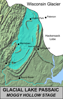
Lake Passaic was a prehistoric proglacial lake that existed in northern New Jersey in the United States at the end of the last ice age approximately 19,000-14,000 years ago. The lake was formed of waters released by the retreating Wisconsin Glacier, which had pushed large quantities of earth and rock ahead of its advance, blocking the previous natural drainage of the ancestral Passaic River through a gap in the central Watchung Mountains. The lake persisted for several thousand years as melting ice and eroding moraine dams slowly drained the former lake basin. The effect of the lake’s creation permanently altered the course of the Passaic River, forcing it to take a circuitous route through the northern Watchung Mountains before spilling out into the lower piedmont.

Watchung Mountains

The Watchung Mountains are a group of three long low ridges of volcanic origin, between 400 and 500 feet high, lying parallel to each other in northern New Jersey in the United States. The Watchung Mountains are known for their numerous scenic vistas overlooking New York City, Newark and New Jersey skylines, as well as their isolated ecosystems containing rare plants, endangered wildlife, rich minerals, and globally imperiled trap rock glade communities. The ridges traditionally contained the westward spread of urbanization, forming a significant geologic barrier beyond the piedmont west of the Hudson River; the town of Newark, for example, once included lands from the Hudson to the base of the mountains. Later treaties moved the boundary to the top of the mountain, to include the springs. The Watchungs are basalt uplifts, geologically similar to the Palisades along the Hudson river. In many places, however, the mountains have become sinuous islands of natural landscape within the suburban sprawl covering much of contemporary northeastern New Jersey. Parks, preserves, and numerous historical sites dot the valleys and slopes of the mountains, providing recreational and cultural activities to one of the most densely populated regions of the nation.

Rockaway River river in the United States of America

The Rockaway River is a tributary of the Passaic River, approximately 35 mi (56 km) long, in northern New Jersey in the United States. The upper course of the river flows through a wooded mountainous valley, whereas the lower course flows through the populated New Jersey suburbs and former industrial area west of New York City. It drains an area of approximately 130 sq mi (340 km²).

Hatfield Swamp is a fresh water wetland area in the US state of New Jersey, forming what might be considered the "second bank" of the Passaic River between Morris and Essex counties.

Kittatinny Mountain mountain in United States of America

Kittatinny Mountain is a long ridge traversing across northwestern New Jersey running in a northeast-southwest axis, a continuation across the Delaware Water Gap of Pennsylvania's Blue Mountain Ridge. It is the first major ridge in the far northeastern extension of the Ridge and Valley province of the Appalachian Mountains, and reaches its highest elevation, 1,803 feet, at High Point in Montague Township. Kittatinny Mountain forms the eastern side of Wallpack Valley; the western side comprises the Wallpack Ridge (highest elevation: 928 feet above sea level.

Lake Hiawatha, New Jersey Unincorporated community in New Jersey, United States

Lake Hiawatha is an unincorporated community located within Parsippany-Troy Hills in Morris County, New Jersey, United States. The area is served as United States Postal Service as ZIP code 07034. As of the 2010 United States Census, the population for ZIP Code Tabulation Area 07034 was 9,360.

Great Swamp National Wildlife Refuge protected area in New Jersey, United States

The Great Swamp National Wildlife Refuge is located in Morris County, New Jersey. Established in 1960, it is one of more than 550 refuges in the National Wildlife Refuge System.

Moses Coulee A canyon in the Waterville plateau region of Douglas County, Washington

Moses Coulee is a canyon in the Waterville plateau region of Douglas County, Washington. Moses Coulee is the second-largest and westernmost canyon of the Channeled Scablands, located about 30 kilometres (19 mi) to the west of the larger Grand Coulee. This water channel is now dry, but during glacial periods, large outburst floods with discharges greater than 600,000 m3/s (21,000,000 cu ft/s) carved the channel. While it's clear that megafloods from Glacial Lake Missoula passed through and contributed to the erosion of Moses Coulee, the origins of the coulee are less clear. Some researchers propose that floods from glacial Lake Missoula formed Moses Coulee, while others suggest that subglacial floods from the Okanogan Lobe incised the canyon. The mouth of Moses Coulee discharges into the Columbia River.

Withrow Moraine and Jameson Lake Drumlin Field

The Withrow Moraine and Jameson Lake Drumlin Field is a National Park Service–designated privately owned National Natural Landmark located in Douglas County, Washington state, United States. Withrow Moraine is the only Ice Age terminal moraine on the Waterville Plateau section of the Columbia Plateau. The drumlin field includes excellent examples of glacially-formed elongated hills.

Loantaka Brook is a tributary of the Passaic River in New Jersey in the United States.

Geology of Pennsylvania

The Geology of Pennsylvania consists of six distinct physiographic provinces, three of which are subdivided into different sections. Each province has its own economic advantages and geologic hazards and plays an important role in shaping everyday life in the state. They are: the Atlantic Coastal Plain Province, the Piedmont Province, the New England Province, the Ridge and Valley Province, the Appalachian Plateau Province, and the Central Lowlands Province.

Napeequa River river in the United States of America

The Napeequa River is a 19-mile (31 km) long river in the U.S. state of Washington on the east side of the Cascade Range. It rises in northwest Chelan County and flows southwest into the White River near Twin Lakes. The White River flows into Lake Wenatchee. The Napeequa River and its valley are notable for their beauty and isolation, as well as their interesting geological history. It flows through an isolated southeast-trending valley characterized by a broad meadows surrounded by rugged mountains. The Chiwawa Mountains, or Chiwawa Ridge mark the east side of the valley, separating the Napeequa and Chiwawa Rivers. To the west the White Mountains separate the Napeequa from the White River. Both are sub-ranges of the Cascade Range.

New Jersey is a very geologically and geographically diverse region in the United States' Middle Atlantic region, offering variety from the Appalachian Mountains and the Highlands in the state's northwest, to the Atlantic Coastal Plain region that encompasses both the Pine Barrens and the Jersey Shore. The state's geological features have impacted the course of settlement, development, commerce and industry over the past four centuries.

The Lenape Trail is a trail connecting Newark, New Jersey with Roseland, New Jersey. It was established in 1982. It is the fifth longest trail in the state behind the Delaware and Raritan Canal Trail, the Appalachian Trail, the completed section of the Highlands Trail in the state and the Batona Trail. The Lenape trail traverses Newark and its suburbs, as well as the Watchung Mountains and Passaic Meadows. Because of the steepness of the Watchung Mountains and the flood-prone nature of the Passaic Meadows, the former basin of Glacial Lake Passaic, these areas have remained much less developed than the rest of the northeastern part of the state. This trail therefore offers hikers an opportunity to see cultural and historical sites of an urban trail, as well as large natural and undeveloped areas. The trail's proximity to New York City and the various ridges it traverses, including Forest Hill, Orange Mountain, and Second Watchung Mountain, offer many views of the skyline. The Lenape Trail forms a segment of the Liberty-Water Gap Trail and incorporates the West Essex Trail, the Lenape Trail's only rail-to-trail section. The Lenape Trail also connects with Morris County's Patriots Path trail system on its western terminus.

Goffle Hill mountain in United States of America

Goffle Hill, also referred to as Goffle Mountain and historically known as Totoway Mountain and Wagaraw Mountain, is a range of the trap rock Watchung Mountains on the western edge of the Newark Basin in northern New Jersey. The hill straddles part of the border of Bergen County and Passaic County, underlying a mostly suburban setting. While hosting patches of woodlands, perched wetlands, and traprock glades, the hill is largely unprotected from development. Extensive quarrying for trap rock has obliterated large tracts of the hill in North Haledon, and Prospect Park. Conservation efforts seeking to preserve undeveloped land, such as the local Save the Woods initiative (2007–present), are ongoing.

North Shore Highlands

The North Shore Highlands are a physiographic and ecological region of the U.S. state of Minnesota in central North America. They were formed by a variety of geologic processes, but are principally composed of rock created by magma and lava from a rift about 1.1 billion years ago, which rock formations are interspersed with and overlain by glacial deposits. Their ecology derives from these origins, with thin, rocky soils supporting flora and fauna typical of their northern, inland location.

Troy Meadows

Troy Meadows is a 3,100-acre (1,300 ha) nature preserve in Parsippany, Morris County, New Jersey. Along with the Great Swamp, it is one of the remnants of Glacial Lake Passaic. It was designated a National Natural Landmark in 1967. It is the largest freshwater marsh in New Jersey, the Whippany River goes through the swamp before connecting with the Rockaway River. It is part of the Northeastern coastal forests ecoregion.

References

  1. US Gazetteer Physical Feature: Swamp - Lee Meadows.

Coordinates: 40°50′24″N74°26′43″W / 40.8401°N 74.4454°W / 40.8401; -74.4454

Geographic coordinate system Coordinate system

A geographic coordinate system is a coordinate system that enables every location on Earth to be specified by a set of numbers, letters or symbols. The coordinates are often chosen such that one of the numbers represents a vertical position and two or three of the numbers represent a horizontal position; alternatively, a geographic position may be expressed in a combined three-dimensional Cartesian vector. A common choice of coordinates is latitude, longitude and elevation. To specify a location on a plane requires a map projection.