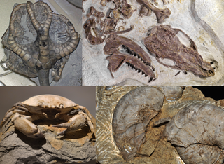
A fossil is any preserved remains, impression, or trace of any once-living thing from a past geological age. Examples include bones, shells, exoskeletons, stone imprints of animals or microbes, objects preserved in amber, hair, petrified wood and DNA remnants. The totality of fossils is known as the fossil record.

The Mariana Trench is an oceanic trench located in the western Pacific Ocean, about 200 kilometres (124 mi) east of the Mariana Islands; it is the deepest oceanic trench on Earth. It is crescent-shaped and measures about 2,550 km (1,580 mi) in length and 69 km (43 mi) in width. The maximum known depth is 10,984 ± 25 metres at the southern end of a small slot-shaped valley in its floor known as the Challenger Deep. The deepest point of the trench is more than 2 km (1.2 mi) farther from sea level than the peak of Mount Everest.

South Georgia and the South Sandwich Islands (SGSSI) is a British Overseas Territory in the southern Atlantic Ocean. It is a remote and inhospitable collection of islands, consisting of South Georgia and a chain of smaller islands known as the South Sandwich Islands. South Georgia is 165 kilometres (103 mi) long and 35 kilometres (22 mi) wide and is by far the largest island in the territory. The South Sandwich Islands lie about 700 kilometres (430 mi) southeast of South Georgia. The territory's total land area is 3,903 km2 (1,507 sq mi). The Falkland Islands are about 1,300 kilometres (810 mi) west from its nearest point.

Stromatolites or stromatoliths are layered sedimentary formations (microbialite) that are created mainly by photosynthetic microorganisms such as cyanobacteria, sulfate-reducing bacteria, and Pseudomonadota. These microorganisms produce adhesive compounds that cement sand and other rocky materials to form mineral "microbial mats". In turn, these mats build up layer by layer, growing gradually over time.
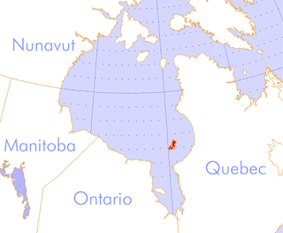
The Belcher Islands are an archipelago in the southeast part of Hudson Bay near the centre of the Nastapoka arc. The Belcher Islands are spread out over almost 3,000 km2 (1,200 sq mi). Administratively, they belong to the Qikiqtaaluk Region of Nunavut, Canada. The hamlet of Sanikiluaq is on the north coast of Flaherty Island and is the southernmost in Nunavut. Along with Flaherty Island, the other large islands are Kugong Island, Tukarak Island, and Innetalling Island. Other main islands in the 1,500–island archipelago are Moore Island, Wiegand Island, Split Island, Snape Island and Mavor Island, while island groups include the Sleeper Islands, King George Islands, and Bakers Dozen Islands.

Shark Bay is a World Heritage Site in the Gascoyne region of Western Australia. The 23,000-square-kilometre (8,900 sq mi) area is located approximately 800 kilometres (500 mi) north of Perth, on the westernmost point of the Australian continent. UNESCO's listing of Shark Bay as a World Heritage Site reads:

Sylvia Alice Earle is an American marine biologist, oceanographer, explorer, author, and lecturer. She has been a National Geographic Explorer at Large since 1998. Earle was the first female chief scientist of the U.S. National Oceanic and Atmospheric Administration, and was named by Time Magazine as its first Hero for the Planet in 1998.

Virgin Gorda is the third-largest island and second-most populous of the British Virgin Islands (BVI).

Cervantes is a town in Western Australia located about 198 kilometres (123 mi) north-north-west of the state capital, Perth, in the Shire of Dandaragan local government area. At the 2016 census, Cervantes had a population of 527. The town was named after a ship that was wrecked nearby. The ship, in turn, was named after Miguel de Cervantes, author of Don Quixote.
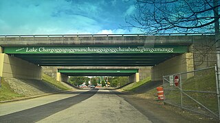
Lake Chaubunagungamaug, also known as Webster Lake, is a lake in the town of Webster, Massachusetts. It is located near the Connecticut border and has a surface area of 1,442 acres. Since 1921, the lake has also been known by a much longer name having 45 letters comprising fourteen syllables: Lake Chargoggagoggmanchauggagoggchaubunagungamaugg. The lake has become famous beyond Central Massachusetts for having the longest name of any geographic feature in all of the United States.
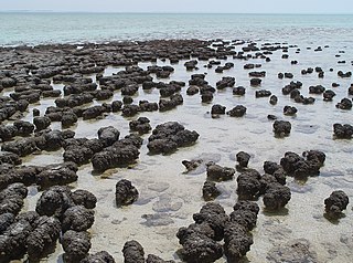
The Hamelin Pool Marine Nature Reserve is a protected marine nature reserve located in the UNESCO World Heritage–listed Shark Bay in the Gascoyne region of Western Australia. The 127,000-hectare (310,000-acre) nature reserve boasts the most diverse and abundant examples of living marine stromatolites in the world, monuments to life on Earth over 3,500 million years BP.
Patos Island is a small island in the San Juan Islands of the U.S. state of Washington. Since 1893, it has been home to the Patos Island Lighthouse, guiding vessels through Boundary Pass between Canada and the United States. The name comes from the Spanish pato, meaning "duck," which was given to the island in 1792 by Commander Dionisio Alcalá Galiano of the Sutil and Captain Cayetano Valdés y Flores of the Mexicana.

Clark Island is an island in the San Juan Islands of the Pacific Northwest, located near Barnes Island off the northeast coast of Orcas Island. It is part of the U.S. state of Washington. Clark Island Marine State Park, which encompasses the entire 55-acre (22 ha) island, has two picnicking sites, 15 primitive campsites, and nine mooring buoys.
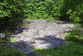
Petrified Sea Gardens, also once known as Ritchie Park, is a National Historic Landmark on Petrified Sea Gardens Road in Saratoga Springs, New York. It preserves a bed of ancient stromatolites in a Cambrian rock layer, which were the first to be recognized and understood for what they are. The site was a private park open to the public for many years, but is now closed. The site was designated a National Natural Landmark in 1967, and a National Historic Landmark in 1999.

St Francis Island is an island on the south coast of South Australia near Ceduna. It is part of the Nuyts Archipelago. It was one of the first parts of South Australia to be discovered and named by Europeans, along with St Peter Island, mapped by François Thijssen in 't Gulden Zeepaert in 1627.
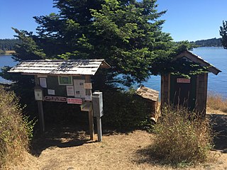
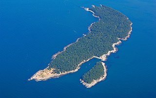
Blind Island Marine State Park is a public recreation area consisting of the entirety of Blind Island, a three-acre (1.2 ha) island at the entrance to Blind Bay on Shaw Island in San Juan County, Washington. It is part of the San Juan Islands National Monument. The island lies one-third of a mile west of the Shaw Island ferry terminal and has 1,280 feet (390 m) of saltwater shoreline. The park is cooperatively managed by the U.S. Bureau of Land Management and Washington State Parks.

Greyhound Rock State Marine Conservation Area (SMCA) is one of two adjoining marine protected areas off the coast of San Mateo County and Santa Cruz County, on California's central coast. The area is approximately 55 miles (89 km) south of San Francisco. The SMCA is 11.81 square miles (30.6 km2). Within the SMCA fishing and take of all living marine resources is prohibited except the recreational take of giant kelp, squid, salmon, and other finfish, subject to various conditions. Also permitted is the commercial take of giant kelp, salmon, and squid, subject to various conditions.

The Grand Canyon Supergroup is a Mesoproterozoic to a Neoproterozoic sequence of sedimentary strata, partially exposed in the eastern Grand Canyon of Arizona. This group comprises the Unkar Group, Nankoweap Formation, Chuar Group and the Sixtymile Formation, which overlie Vishnu Basement Rocks. Several notable landmarks of the Grand Canyon, such as the Isis Temple and Cheops Pyramid, and the Apollo Temple, are surface manifestations of the Grand Canyon Supergroup.
Doe Island State Park is a public recreation area comprising the entirety of Doe Island, a seven-acre (2.8 ha) island lying some 300 feet (91 m) off the eastern flank of Orcas Island in the San Juan Islands group in San Juan County, Washington. It has 2,049 feet (625 m) of shoreline and a trail three-tenths of a mile long that circles the island. It is only accessible by water. The Washington State Parks originally acquired a portion of the island from the Bureau of Land Management in 1964 for $15.27, with a second acquisition in 1967 from the DNR at no cost.
Saddlebag Island Marine State Park is a public recreation area made up of 26-acre (11 ha) Saddlebag Island, part of the San Juan Islands, in Skagit County, Washington. The island sits in Padilla Bay four miles (6.4 km) northeast of Anacortes, Washington. Dot Island and Huckleberry Island lie nearby. Saddlebag Island was held in private ownership until 1974, when the state purchased it for $192,000 for use as a state park.
