Dale or dales may refer to:

Leyton is a town in east London, England, within the ceremonial county of Greater London and the ancient county of Essex. It borders Walthamstow to the north, Leytonstone to the east, and Stratford to the south, with Clapton, Hackney Wick and Homerton, across the River Lea, to the west. The area includes New Spitalfields Market, Leyton Orient Football Club, as well as part of the Queen Elizabeth Olympic Park. The town consists largely of terraced houses built between 1870 and 1910, interspersed with some modern housing estates. It is 6.2 miles (10 km) north-east of Charing Cross.

The London Borough of Waltham Forest is a London borough in north-east London, England. Its population is estimated to be 276,983 in 2019. It borders five other London boroughs: Enfield to the north-west, Haringey to the west, Hackney to the south-west, Newham to the south-east and Redbridge to the east, as well as the non-metropolitan county of Essex to the north.
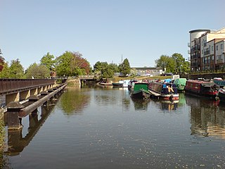
The River Lea is in South East England. It originates in Bedfordshire, in the Chiltern Hills, and flows southeast through Hertfordshire, along the Essex border and into Greater London, to meet the River Thames at Bow Creek. It is one of the largest rivers in London and the easternmost major tributary of the Thames.

The Lower Lea Valley is the southern end of the Lea Valley which surrounds the River Lea. It is part of the Thames Gateway redevelopment area and was the location of the 2012 Summer Olympics.

Lee Valley Regional Park is a 10,000-acre (40 km2) 26 miles (42 km) long linear park, much of it green spaces, running through the northeast of Greater London, Essex and Hertfordshire from the River Thames to Ware, through areas such as Stratford, Clapton, Tottenham, Enfield, Walthamstow, Cheshunt, Broxbourne and Hoddesdon in an area generally known as the Lea Valley. Greater London's largest park, Lee Valley Park is more than four times the size of Richmond Park, extending beyond Greater London's borders into the neighbouring counties of Hertfordshire and Essex.

Edmonton is a town in north London, England within the London Borough of Enfield. The northern part of the town is known as Lower Edmonton, and the southern part as Upper Edmonton. Situated 8.4 miles (13.5 km) north-northeast of Charing Cross, it borders Ponders End and Bush Hill Park in Enfield to the north, Chingford to the east, and Tottenham to the south, with Palmers Green and Winchmore Hill to the west. The population of Edmonton was 82,472 as of 2011.

Enfield Lock is an area in the London Borough of Enfield, north London. It is approximately located east of the Hertford Road between Turkey Street and the Holmesdale Tunnel overpass, and extends to the River Lee Navigation, including the Enfield Island Village. The locality gains its name from the lock on the River Lee Navigation. Today's Enfield Lock was rebuilt in 1922. The area forms part of the Lee Valley Park and the Enfield Lock Conservation Area. On its eastern boundary Enfield Lock has marshland formerly used as a testing site between the Royal Small Arms Factory and the Gunpowder Mills, beyond this is the village of Sewardstone and the Epping forest boundary. To the south is Brimsdown, the north Waltham Cross and to the west Bullsmoor and Freezywater. Enfield Lock forms part of the London boundary.
Walthamstow Marshes, is a 36.7 hectare biological Site of Special Scientific Interest in Walthamstow in the London Borough of Waltham Forest. It was once an area of lammas land – common land used for growing crops and grazing cattle.
Canada is a country in North America.
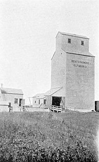
Benito is an unincorporated urban community in the Municipality of Swan Valley West, Manitoba, Canada.

Brimsdown is a neighbourhood of eastern Enfield in the London Borough of Enfield, north London, on the west side of the mid-to-lower Lea Valley.

Ponders End is the southeasternmost part of Enfield, north London, centred on the Hertford Road. Situated to the west of the River Lee Navigation, it became industrialised through the 19th century, similar to the Lea Valley in neighbouring Edmonton and Brimsdown, with manufacturing giving way to warehousing in the late-20th century. The area consists heavily of social housing, with streets also lined with 19th and early-20th century suburban terraced housing.
The Lea Valley, the valley of the River Lea, has been used as a transport corridor, a source of sand and gravel, an industrial area, a water supply for London, and a recreational area. The London 2012 Summer Olympics were based in Stratford, in the Lower Lea Valley. It is very important for London's water supply, as the source of the water transported by the New River aqueduct, but also as the location for the Lee Valley Reservoir Chain, stretching from Enfield through Tottenham and Walthamstow.

Dobbs Weir is both a weir in Hoddesdon, Hertfordshire and an area of Roydon, Essex in England on the River Lea. It is well known for angling, outdoor beauty and watersports. It is overlooked by the Fish and Eels pub.
Pickett's Lock or Picketts Lock is an area of Edmonton, in the London Borough of Enfield. It is bordered by River Lee Navigation to the east, Pickett's Lock Lane to the south, Meridian Way A1055 to the west and the Ponders End industrial area to the north. The area takes its name from Pickett's Lock, a lock on the nearby River Lee Navigation.

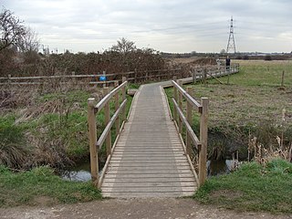
The Lea Valley Walk is a 50-mile (80 km) long-distance path located between Leagrave, the source of the River Lea near Luton, and the Thames, at Limehouse Basin, Limehouse, east London. From its source much of the walk is rural. At Hertford the path follows the towpath of the River Lee Navigation, and it becomes increasingly urbanised as it approaches London. The walk was opened in 1993 and is waymarked throughout using a swan logo.

Fishers Green is a settlement 1 mile (1.6 km) to the north of the town of Waltham Abbey, Essex, England, in the parish of Waltham Abbey. It lies on the flood plain of the River Lea.

The Lee Valley Reservoir Chain is located in the Lee Valley, and comprises 13 reservoirs that supply drinking water to London.

The River Lee Country Park is located in the Lee Valley Park and is managed by the Lee Valley Regional Park Authority. Covering 1,000 acres (400 ha) on either side of the River Lee Navigation between Waltham Abbey and Broxbourne, it is an area of lakes, watercourses, open spaces and three Sites of Special Scientific Interest (SSSI) linked by footpaths and cycle tracks.