
Leyton is a town in east London, England, within the London Borough of Waltham Forest. It borders Walthamstow to the north, Leytonstone to the east, and Stratford to the south, with Clapton, Hackney Wick and Homerton, across the River Lea, to the west. The area includes New Spitalfields Market, Leyton Orient Football Club, as well as part of the Queen Elizabeth Olympic Park. The town consists largely of terraced houses built between 1870 and 1910, interspersed with some modern housing estates. It is 6.2 miles (10 km) north-east of Charing Cross.

The London Borough of Enfield is a London borough in North London. It borders the London boroughs of Barnet to the west, Haringey to the south, and Waltham Forest to the southeast. To the north are the districts of Hertsmere, Welwyn Hatfield and Broxbourne, and to the east is Epping Forest District in Essex. The local authority is Enfield London Borough Council. Enfield's population is estimated to be 333,794; the main towns in the borough are Edmonton, Enfield, Southgate and Palmers Green. Enfield is the northernmost London borough.

Cheshunt is a town in the Borough of Broxbourne in Hertfordshire, England, 12 miles (19 km) north of Central London on the River Lea and Lee Navigation and directly south of Broxbourne. It contains a section of the Lee Valley Park, including much of the River Lee Country Park. To the north lies Broxbourne and Wormley, Waltham Abbey to the east, Waltham Cross and Enfield to the south, and Cuffley to the west.

Waltham Abbey is a town and civil parish in the Epping Forest District of Essex, within the metropolitan and urban area of London, England, 13.5 miles (21.7 km) north-east of Charing Cross. It lies on the Greenwich Meridian, between the River Lea in the west and Epping Forest in the east, with large sections forming part of the Metropolitan Green Belt.
Angel Road was a railway station in Edmonton in the London Borough of Enfield, north London, on the Lea Valley line that forms part of the West Anglia Main Line, 7 miles 57 chains (12.4 km) down the line from London Liverpool Street. It was between Northumberland Park and Ponders End in Travelcard zone 4 and had the three-letter station code AGR. It is located beneath the A406 flyover of Meridian Way, and was accessed via a footpath from Conduit Lane, on an adjacent flyover to the north. The station's immediate surroundings include non-manufacturing industrial businesses and a former gas works.

Enfield Town is one of three northern termini of the Lea Valley lines on the London Overground network in England. It is the most central of several stations in the London Borough of Enfield, north London. It is 10 miles 55 chains (17.2 km) down the line from London Liverpool Street, the southern terminus.

Edmonton Green is a London Overground station on the Lea Valley lines which formerly was a part of the West Anglia Main Line, located in Edmonton in the London Borough of Enfield, north London. It is 8 miles 45 chains (13.8 km) down the line from London Liverpool Street and is situated between Silver Street to the south and Bush Hill Park and Southbury to the north.

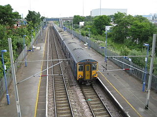
Turkey Street is a London Overground station on the Southbury Loop section of the Lea Valley lines, located in the Bullsmoor area to the north of Enfield in north London. It is 12 miles 16 chains (19.6 km) down the line from London Liverpool Street and is situated between Southbury and Theobalds Grove.

Enfield North is a peripheral Greater London constituency created in 1974 and represented in the House of Commons of the UK Parliament since 2019 by Feryal Clark of the Labour Party.

Edmonton is a town in north London, England within the London Borough of Enfield, a local government district of Greater London. The northern part of the town is known as Lower Edmonton or Edmonton Green, and the southern part as Upper Edmonton. Situated 8.4 miles (13.5 km) north-northeast of Charing Cross, it borders Enfield to the north, Chingford to the east, and Tottenham to the south, with Palmers Green and Winchmore Hill to the west. The population of Edmonton was 82,472 as of 2011.
Enfield Lock is an area in the London Borough of Enfield, north London. It is approximately located east of the Hertford Road between Turkey Street and the Holmesdale Tunnel overpass, and extends to the River Lee Navigation, including the Enfield Island Village. The locality gains its name from the lock on the River Lee Navigation. Today's Enfield Lock was rebuilt in 1922. The area forms part of the Lee Valley Park and the Enfield Lock Conservation Area. On its eastern boundary Enfield Lock has marshland formerly used as a testing site between the Royal Small Arms Factory and the Gunpowder Mills, beyond this is the village of Sewardstone and the Epping forest boundary. To the south is Brimsdown, the north Waltham Cross and to the west Bullsmoor and Freezywater. Enfield Lock forms part of the London boundary.

Notre Dame Catholic High School in Sheffield, South Yorkshire, England, was established in the 1850s by the Sisters of Notre Dame, a religious order. It was, for many decades, a fee paying school. It currently has 1400 students, with a 1:17.3 Teacher: Student ratio.

Freezywater is a neighbourhood of the traditional broad definition of Enfield in the London Borough of Enfield, North London. It has a border with Hertfordshire. It is between Bullsmoor to the west, Enfield Lock to the east, Enfield Wash to the south, and Waltham Cross, Hertfordshire to the north. It became more than a hamlet at the beginning of the 20th century.

Ponders End is the southeasternmost part of Enfield, north London, centred on the Hertford Road. Situated to the west of the River Lee Navigation, it became industrialised through the 19th century, similar to the Lea Valley in neighbouring Edmonton and Brimsdown, with manufacturing giving way to warehousing in the late-20th century. The area features much social housing, with streets also lined with suburban terraced housing from the 19th and early 20th centuries.

Chessington School is a co-educational secondary school with a sports centre, in the Royal Borough of Kingston upon Thames, Greater London. The current building was opened in September 2009.
The Bicester School is a mixed, multi-heritage, secondary school, with 963 students. It is situated in Bicester, Oxfordshire, England, and occupies a 32-acre (130,000 m2) site leading off Queens Avenue.

Bulls Cross is a road and hamlet in Enfield, England, on the outskirts of north London, forming part of the Metropolitan Green Belt. Although it now lies within the ceremonial county of Greater London, prior to 1965 it was in the historic county of Middlesex. The area is situated west of the Great Cambridge Road, and south of the M25 motorway. Crews Hill is to the west, Bury Green to the north, and Bullsmoor to the east.
Emerson Park Academy, formerly Hornchurch Grammar School, is an academy school located in the Hornchurch area of the London Borough of Havering, England. It is situated just east of Emerson Park, between Hornchurch and Upminster.

Tottenham is a town in north London, England, within the London Borough of Haringey. It is located in the ceremonial county of Greater London. Tottenham is centred 6 mi (10 km) north-northeast of Charing Cross, bordering Edmonton to the north, Walthamstow, across the River Lea, to the east, and Stamford Hill to the south, with Wood Green and Harringay to the west.

51.5976°N 0.0704°W
