Greer, Arizona

Last updated

Greer, Arizona
GreerAZ.jpg
Aspens in Greer
USA Arizona location map.svg
Red pog.svg
Greer
Coordinates: 34°00′19″N109°27′39″W / 34.00528°N 109.46083°W / 34.00528; -109.46083
CountryUnited States
State Arizona
County Apache
Area
[1]
  Total0.53 sq mi (1.37 km2)
  Land0.53 sq mi (1.37 km2)
  Water0.00 sq mi (0.00 km2)
Elevation
[2]
8,403 ft (2,561 m)
Population
 (2020)
  Total58
  Density109.85/sq mi (42.42/km2)
Time zone UTC-7 (MST)
  Summer (DST) UTC-6 (MDT)
ZIP Code [3]
85927
Area code 928
FIPS code 04-29850
GNIS feature ID2582792 [2]

Greer is an unincorporated community and census-designated place in Apache County, Arizona, United States. Located within the White Mountains of Arizona and surrounded by the Apache-Sitgreaves National Forest, Greer is the highest town in the state at an elevation of approximately 8,400 feet (2,560 m). As of the 2020 census it had a population of 58. Greer was founded circa 1879 by Mormon settlers from Utah. [4] The Greer post office has the ZIP code of 85927. [5]

Contents

History

Originally known as Lee Valley, Greer was founded by Latter-day Saint Willard Lee and his family in 1879. When the Lee Valley post office was built they requested a shorter name, so Greer (after Americus Vespucius Greer, a town planner who had recently moved to the area) was settled on and the small community continued to gradually develop. [6] [7] In 1897, a single-room schoolhouse was built. A church, library, and restaurants were later built including Molly Butler Lodge and Restaurant, which is the oldest guest lodge and restaurant in Arizona. Today there are multiple resorts, rental cabins, a general store, and two fire stations.

Just west of Greer is the remnants of the Apache Railway. The railway spanned from Holbrook near Interstate 40 and traveled south traveling through Snowflake, Pinetop-Lakeside and McNary before reaching the logging camp at Maverick, Arizona, south of Greer. Logging operations started in 1918 and in 1964 the White Mountain Scenic Railroad operated on the line. The scenic railroad ceased operations in 1976 and in 1982 the line from Maverick to McNary was removed.[ citation needed ]

Surrounding the town, the scars of the Wallow Fire can be seen. The massive wildfire started in the White Mountains near Alpine, Arizona on May 29, 2011, due to the mismanagement of a campfire. The communities of Alpine, Blue River, Greer, Nutrioso, Sunrise, Springerville, and Eagar, Arizona, as well as Luna, New Mexico were evacuated. On June 8, 2011, the Wallow Fire reached the town of Greer and destroyed multiple buildings but most of the structures in town remain intact. The fire continued to grow till July 8 at 6 p.m., when it declared 100% contained. The fire destroyed 72 building and injured 16 wildland firefighters. It burned 522,642 acres (2,115 km2) in Arizona and 15,407 acres (62 km2) in New Mexico, becoming the largest wildfire in Arizona history surpassing the Rodeo-Chediski Fire which burned 468,638 acres along the Mogollon Rim in 2002.[ citation needed ]

Geography

The Little Colorado River during summer Greer SW01.jpg
The Little Colorado River during summer

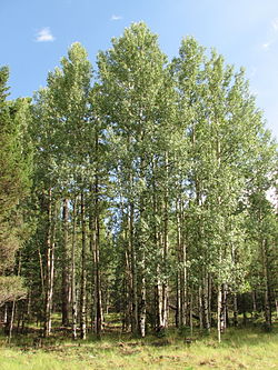
Greer sits at 8,356 feet in elevation and is located in the White Mountains of Arizona near the New Mexico border. It is surrounded by the Apache Sitgreaves National Forest and The little Colorado River flows through the center of town. Its position in the valley of the Little Colorado River near various lakes means that temperatures are significantly milder than surrounding areas. While Greer is a four-hour drive from Phoenix and a four-and-a-half hour drive from Tucson, it remains one of the most popular summer vacation destinations in Arizona as it is consistently 20-30 °F cooler than the deserts. Greer is about 20 minutes or 16 miles (26 km) south of Springerville and Eagar, accessed by paved road via Highways 260 and 373. From Show Low and Pinetop-Lakeside, it is 40 miles (64 km) or approximately a 45-minute drive east using Highways 260 and 373. Greer is home to Sunrise Ski Resort, the largest ski park in the state. The resort has 7 lifts that span over 3 mountains, Apache peak (11,100 ft), Cyclone Peak (10,700 ft), and Sunrise peak (10,700 ft).

Climate

Access to Greer in the winter 20181207-FS-APACHE-SITGREAVES-LSC-0157 (40277084703).jpg
Access to Greer in the winter

Greer has a Humid continental climate (Köppen Dsb) with warm summers coupled with chilly nights and cold, snowy winters. Due to its high elevation at more the 8,000 feet (2,438 m) summer temperatures range from the mid 60s to high 70s but the area will occasionally reach temperatures around 80 °F (27 °C) or higher. During the summer months, monsoon storms develop daily in the late morning and early afternoon hours, bringing heavy rain, strong wind, thunder, lightning, and even hail. These thunderstorms help lower temperatures of the surrounding areas. In July, the average high temperature is 76.0 °F (24.4 °C) with an average low temperature of 46.8 °F (8.2 °C) and in January, the average high temperature is 42.6 °F (5.9 °C) with an average low temperature of 13.5 °F (−10.0 °C).

Winters are harsh with nighttime lows in the single digits and daytime temps in the 40s. Snowstorms and flurries are common during the winter months. Greer gets 97.5 inches (248 cm) of snowfall annually and accumulating snow can reach up to 6 feet. Ice forms on the surrounding lakes in late November and doesn't thaw till early March. The White Mountains is one of the coldest and wettest places in the state. The official all-time record low in Arizona history was recorded at −40 °F/°C near Hawley lake on January 7, 1971. White Mountains also holds the record for most precipitation in a calendar year at 58.92 inches (1496.6 mm)

On Monday, November 5, 2001, the Northern Lights were visible from Greer and other areas around the Mogollon Rim and White Mountains including Payson, Heber-Overgaard, Show Low, Eagar, Alpine, and McNary. At 8:00-10:30 pm, the people of east central Arizona were treated to the natural light display due to extremely strong Solar flares that allowed the Aurora Borealis to be seen this far south. The lights appeared a deep red and pink hue.

Climate data for Greer, Arizona [lower-alpha 1] (1991–2020 normals, extremes 1916–2011)
MonthJanFebMarAprMayJunJulAugSepOctNovDecYear
Record high °F (°C)66
(19)
65
(18)
75
(24)
75
(24)
89
(32)
89
(32)
90
(32)
87
(31)
86
(30)
78
(26)
74
(23)
63
(17)
90
(32)
Mean maximum °F (°C)55.2
(12.9)
54.9
(12.7)
62.0
(16.7)
69.9
(21.1)
76.7
(24.8)
83.0
(28.3)
84.9
(29.4)
80.6
(27.0)
75.6
(24.2)
70.8
(21.6)
61.4
(16.3)
55.6
(13.1)
85.6
(29.8)
Mean daily maximum °F (°C)42.6
(5.9)
44.7
(7.1)
50.2
(10.1)
57.4
(14.1)
66.0
(18.9)
75.9
(24.4)
76.0
(24.4)
73.4
(23.0)
69.9
(21.1)
61.0
(16.1)
51.5
(10.8)
42.9
(6.1)
59.3
(15.2)
Daily mean °F (°C)28.1
(−2.2)
30.2
(−1.0)
35.9
(2.2)
41.4
(5.2)
49.5
(9.7)
58.4
(14.7)
61.4
(16.3)
59.7
(15.4)
55.3
(12.9)
45.6
(7.6)
36.3
(2.4)
28.4
(−2.0)
44.2
(6.8)
Mean daily minimum °F (°C)13.5
(−10.3)
15.7
(−9.1)
21.5
(−5.8)
25.5
(−3.6)
33.0
(0.6)
41.0
(5.0)
46.8
(8.2)
45.9
(7.7)
40.8
(4.9)
30.2
(−1.0)
21.2
(−6.0)
13.8
(−10.1)
29.1
(−1.6)
Mean minimum °F (°C)−2.6
(−19.2)
1.1
(−17.2)
7.0
(−13.9)
14.6
(−9.7)
22.0
(−5.6)
31.6
(−0.2)
41.7
(5.4)
41.8
(5.4)
31.8
(−0.1)
16.1
(−8.8)
6.3
(−14.3)
−4.6
(−20.3)
−8.0
(−22.2)
Record low °F (°C)−24
(−31)
−21
(−29)
−15
(−26)
−4
(−20)
8
(−13)
24
(−4)
33
(1)
30
(−1)
20
(−7)
6
(−14)
−13
(−25)
−20
(−29)
−24
(−31)
Average precipitation inches (mm)1.22
(31)
1.32
(34)
0.92
(23)
0.50
(13)
0.67
(17)
0.49
(12)
4.05
(103)
4.79
(122)
2.37
(60)
1.29
(33)
1.09
(28)
0.57
(14)
19.28
(490)
Average snowfall inches (cm)20.1
(51)
21.0
(53)
15.8
(40)
5.3
(13)
0.7
(1.8)
0.1
(0.25)
0.0
(0.0)
0.0
(0.0)
0.0
(0.0)
1.5
(3.8)
9.7
(25)
18.4
(47)
92.6
(234.85)
Average extreme snow depth inches (cm)12.4
(31)
15.8
(40)
10.8
(27)
2.8
(7.1)
0.5
(1.3)
0.0
(0.0)
0.0
(0.0)
0.0
(0.0)
0.0
(0.0)
1.4
(3.6)
4.9
(12)
10.6
(27)
20.1
(51)
Average precipitation days (≥ 0.01 in)5.55.54.33.33.73.514.916.27.84.83.84.878.1
Average snowy days (≥ 0.1 in)6.25.34.02.00.30.10.00.00.00.73.15.026.7
Source: NOAA (snow/snow days 19812010) [8] [9]

Flora and Fauna

There is a diverse abundance of flora and fauna around Greer. Trees like Narrowleaf Cottonwood, Maple, Boxelder, and Oak, can be found in the riparian habitats in the area Juniper, Pine, Aspen, Fir, and Spruce dot the surrounding landscape. Wildflowers and mushrooms can also be seen in many of the meadows in the White Mountains.

Mexican Grey Wolf near Mount Baldy Mexican grey wolf cheyenne mountain zoo.JPG
Mexican Grey Wolf near Mount Baldy

The White Mountains is one of the most biologically diverse areas in the state. It is home to the Mexican Grey wolf, and as of 2021, there were only 186 wild wolves living in eastern Arizona and western New Mexico. The area is also home to the elusive Apache trout, the state fish of Arizona, the Apache trout is one of two native trout species to the state, the other being the Gila trout. Historically found in nearly every body of water in the White Mountains, the Apache trout was pushed to near extinction. Today, Arizona Game and Fish and the White Mountain Apache Tribe have been working together to conserve and manage both the Apache trout and the Mexican Grey Wolf.

Before westward expansion, the White Mountains were home to Grizzly bears, but in 1936, the last Grizzly bear in Arizona was killed on Escudilla Mountain just east of Big lake.

Aquatic Species

The region is home to many species of fish, both native and nonnative, including Rainbow trout, Brown trout, Brook trout, Tiger trout, Cutthroat trout, Apache trout, Sonora sucker, Desert sucker, Little Colorado River sucker, Little Colorado spinedace, Roundtail chub, Speckled dace, and Loach minnow.

A few species of Crustaceans and Mollusks that can be found here are Northern crawfish, California floater mussel, and Three forks springsnail.

Birds

Many bird species are abundant in the region, including Merriam's turkey, Dusky grouse, Gambles quail, Scaled quail, Montezuma quail, Mourning dove, White-winged dove, and Band-tailed pigeon.

Waterfowl that can be found in and around the region's bodies of water include Great blue heron, Black-crowned night heron, Snowy egret, white-faced ibis, Killdeer plover, Canada goose, Mallard, Redhead, Bufflehead, Cinnamon teal, Green-winged teal, Gadwall, Northern pintail, American wigeon, Northern shoveler, Lesser scaup, Common goldeneye, pied-billed grebe, and eared grebe.

Species of Raptors and Corvids that live in the area include Bald eagle, Golden eagle, Osprey, Red-tailed hawk, Northern goshawk, Coppers hawk, Sharp-shinned hawk, Common black hawk, Swainson's hawk, Rough-legged hawk, Zone-tailed hawk, Northern harrier, Peregrine falcon, Prairie falcon, Merlin, American kestrel, Great horned owl, Long-eared owl, Short-eared owl, Barn owl, Western screech owl, Mexican spotted owl, Northern pygmy owl, Flammulated owl, Northern saw-whet owl, Burrowing owl, Turkey vulture, Common raven, Canada jay, and American crow.

Mammals

The White Mountains, including around Greer, are home to an array of species of mammals:

Hoofed mammals include Elk, Mule deer, White-tailed deer, Javelina, Bighorn Sheep, Pronghorn, Bison, Wild Horses, and Cattle.

Predatory mammals in the region include Black bear, Mountain lion, Bobcat, Mexican grey wolf, Coyote, Grey fox, Striped skunk, Western spotted skunk, Ringtail cat, Raccoon, Coatimundi, River otter, American badger, Black-footed ferret, and Long-tailed weasel

Many species of rodents call the area home, including Beaver, Muskrat, Porcupine, Arizona gray squirrel, Red squirrel, Rock squirrel, Abert's squirrel, Gunnison's prairie dog, Botta's pocket gopher, Golden-mantled ground squirrel, Thirteen-lined ground squirrel, Cliff chipmunk, Least chipmunk, Grey-collared chipmunk, White-throated woodrat, Mexican woodrat, Deer mouse, Pinyon mouse, House mouse, Western harvest mouse, Western jumping mouse, Northern grasshopper mouse, White-footed mouse, Southern red-backed vole, Montane vole, Mexican vole, Montane shrew, and Merriam's shrew

Leporids in this region include the Mountain cottontail rabbit, Eastern cottontail rabbit, and Black-tailed jackrabbit.

Bats found here include the Big brown bat, Little brown bat, Canyon bat, Hoary bat, Pallid bat, Spotted bat, Allen's big-eared bat, Silver-haired bat, Townsend's big-eared bat, Western mastiff bat, Mexican free-tailed bat, Big free-tailed bat, Western small-footed bat, Long-legged bat, Yuma myotis, Arizona myotis, Cave myotis, California myotis, Southwestern myotis, Long-eared myotis, and Fringed myotis.

Reptiles and Amphibians

Despite the region's high elevation and cooler climate, many species of reptiles and amphibians can be found here:

Snakes include Arizona black rattlesnake, Prairie rattlesnake, Black-tailed rattlesnake, Sonoran mountain kingsnake, Chihuahuan nightsnake, Sonoran gophersnake, Terrestrial gartersnake, and Narrow-headed gartersnake.

Lizards in the area include Eastern collared lizard, Greater short-horned lizard, Southwestern fence lizard, Plateau fence lizard, Ornate tree lizard, Many-lined skink, and Plateau stripped whiptail.

The only species of turtle living in the area is the Western painted turtle.

Amphibians that can be found in and near the lakes, rivers, and other bodies of water in the region include Canyon tree frog, Arizona tree frog, Western chorus frog, Chiricahua leopard frog, Northern leopard frog, Arizona toad, Mexican spadefoot, and Barred tiger salamander.

Demographics

Greer is home to few resident individuals or families with a year-round population of just 58 as of the 2020 census. in the Summer the population jumps to around 1,000 people. Many of the homes in the area are cabins or summer getaways for Phoenix and Tucson locals, due to the cooler temperatures. The ZIP code for Greer is 85927 and the area code is 928.

Historical population
CensusPop.Note
2010 41
2020 5841.5%
U.S. Decennial Census [10]

Greer is 0.53 square miles. The median age is 61.5 years and the median household income is $76,114. There are 236 households in the area and 770 housing units which 30.6% are occupied. The median price of an owner occupied housing unit is $584,700. 90% of the people are married.

Attractions/Recreation

Government and infrastructure

Notable people

Related Research Articles

<span class="mw-page-title-main">Heber-Overgaard, Arizona</span> CDP in Navajo County, Arizona

Heber-Overgaard is a census-designated place (CDP) in Navajo County, Arizona, United States. Situated atop the Mogollon Rim, the community lies at an elevation of 6,627 feet (2,020 m). The population was 2,898 at the 2020 census. Heber and Overgaard are technically two unincorporated communities, but as of the 1990 census, their proximity led to the merged name of "Heber-Overgaard".

<span class="mw-page-title-main">White Mountains (Arizona)</span> Mountain range in eastern Arizona

The White Mountains of Arizona are a mountain range and mountainous region in the eastern part of the state, near the border with New Mexico; they are a continuation from the west of the Arizona transition zone–Mogollon Rim, with the Rim ending in western New Mexico. The White Mountains are a part of the Colorado Plateau high country of Northeast Arizona, the Navajo Nation, with the rest of the Plateau in eastern Utah, northwest New Mexico, and southwestern Colorado. Nearby communities include Show Low, Pinetop-Lakeside, Greer, St. Johns, Springerville, Eagar, and McNary. Much of the range is within the Fort Apache Indian Reservation.

The fauna of Maine include several diverse land and aquatic animal species, especially those common to the North Atlantic Ocean and deciduous forests of North America. Some of these creatures' habitats has been reduced or fully removed.

Luna Lake is a natural body of water that covers approximately 75 acres (0.30 km2) of land. It is located about three miles (5 km) southeast of Alpine, Arizona, at the elevation of 7,890 ft (2,400 m), and is the centerpiece of the Luna Lake Wildlife Area.

<span class="mw-page-title-main">Wildlife of North Carolina</span> Flora and fauna of the US state of North Carolina

This article seeks to serve as a field-guide, central repository, and listing for the flora and fauna of the US state of North Carolina and surrounding territories.

<span class="mw-page-title-main">Fauna of the United States</span> Native animals of the United States

The fauna of the United States of America is all the animals living in the Continental United States and its surrounding seas and islands, the Hawaiian Archipelago, Alaska in the Arctic, and several island-territories in the Pacific and in the Caribbean. The U.S. has many endemic species found nowhere else on Earth. With most of the North American continent, the U.S. lies in the Nearctic, Neotropic, and Oceanic faunistic realms, and shares a great deal of its flora and fauna with the rest of the American supercontinent.

<span class="mw-page-title-main">Pine Valley Mountain Wilderness</span>

Pine Valley Mountain Wilderness is a 50,232-acre (203.28 km2) wilderness area located in the Dixie National Forest in the U.S. state of Utah. It is the fourth-largest wilderness area located entirely within the state. The wilderness designation protects the Pine Valley Mountain range, a large rock outcrop surrounded by desert. The Pine Valley Mountains form the Pine Valley Laccolith, one of the largest laccoliths in the United States. Elevations in the wilderness range from 6,000 feet (1,800 m) to 10,365 feet (3,159 m) at the summit of Signal Peak.

<span class="mw-page-title-main">Big Lake (Arizona)</span> Waterbody in Apache County, Arizona

Big Lake is a reservoir in Arizona's White Mountains', with attractive size, recreational activities, and visitor amenities. As with most trout waters in Arizona, catch rates are best in spring, during late April and May after the winter ice thaws. Fishing gets even better later in the summer and into fall until the lake freezes over again in late November. Big Lake is in Apache County and is managed by the Apache-Sitgreaves National Forests.

<span class="mw-page-title-main">Fauna of California</span> Flora and fauna of the US state of California

The fauna of the State of California may be the most diverse in the United States of America. Of the Lower 48 conterminous states, California has the greatest diversity in climate, terrain and geology in general. The state's six life zones are the lower Sonoran (desert); upper Sonoran ; transition ; and the Canadian, Hudsonian, and Arctic zones, comprising California's highest elevations. California’s diverse geography gives rise to dozens of different ecosystems, each of which has its own unique native plants and animals. California is a huge state, the 3rd largest in the U.S., and can range broadly in habitat type.

<span class="mw-page-title-main">Fauna of Nevada</span>

The fauna of the U.S. State of Nevada is mostly species adapted to desert, temperature extremes and to lack of moisture. With an average annual rainfall of only about 7 inches (180 mm), Nevada is the driest – and has the largest percentage of its total area classified as desert – of all states in the United States. Two-thirds of the state is located within the largest desert on the North American continent, the Great Basin Desert, while the lower one-third is the Mojave Desert.

<span class="mw-page-title-main">Wildlife of Missouri</span> Flora and fauna of the US state of Missouri

Missouri is home to a diversity of flora, fauna and funga. There is a large amount of fresh water present due to the Mississippi River, Missouri River, and Lake of the Ozarks, with numerous smaller rivers, streams, and lakes. North of the Missouri River, the state is primarily rolling hills of the Great Plains, whereas south of the Missouri River, the state is dominated by the oak-hickory Central U.S. hardwood forest.

References

  1. "2020 U.S. Gazetteer Files". United States Census Bureau. Retrieved October 29, 2021.
  2. 1 2 U.S. Geological Survey Geographic Names Information System: Greer, Arizona
  3. "Jerome, AZ". Look Up a Zipcode. United States Post Office. 2017. Retrieved May 4, 2017.
  4. "Arizona Mogollon Rim - Payson AZ - Greer Arizona - - tucson.com". Archived from the original on October 20, 2008.
  5. Zip Code Lookup
  6. Byrd H. Granger (1960). Arizona Place Names . University of Arizona Press. p.  12 . Retrieved December 5, 2011.
  7. The Utah Genealogical and Historical Magazine, Volumes 9-10. 1918. p. 184.
  8. "NOWData - NOAA Online Weather Data". National Oceanic and Atmospheric Administration . Retrieved February 16, 2022.
  9. "U.S. Climate Normals Quick Access – Station: Greer, AZ". National Oceanic and Atmospheric Administration. Retrieved January 28, 2023.
  10. "Census of Population and Housing". Census.gov. Retrieved June 4, 2016.
  11. "Post Office™ Location – Greer Archived 2012-08-26 at the Wayback Machine ." United States Postal Service. Retrieved on January 30, 2011.
  12. "Greer Memorial Library Archived 2010-08-22 at the Wayback Machine ." Apache County Library District. Retrieved on January 30, 2011.
  13. "History". Greer AZ Community Center. Retrieved October 29, 2022.
  1. Station Elevation 8,275ft