Toyei, Arizona | |
|---|---|
 Toyei | |
| Coordinates: 35°42′16″N109°56′13″W / 35.70444°N 109.93694°W | |
| Country | United States |
| State | Arizona |
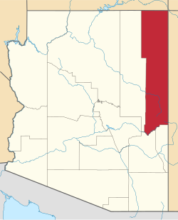
| County | Apache |
| Area | |
• Total | 0.33 sq mi (0.85 km2) |
| • Land | 0.32 sq mi (0.84 km2) |
| • Water | 0.0039 sq mi (0.01 km2) |
| Elevation | 6,532 ft (1,991 m) |
| Population (2020) | |
• Total | 2 |
| • Density | 6.2/sq mi (2.38/km2) |
| Time zone | UTC-7 (MST) |
| FIPS code | 04-75310 |
| GNIS feature ID | 2582882 [2] |
Toyei is a census-designated place (CDP) in Apache County, Arizona, United States. The population was 13 at the 2010 census. [3]