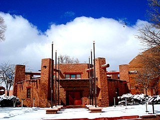
Apache County is a county in the northeast corner of the U.S. state of Arizona. Shaped in a long rectangle running north to south, as of the 2020 census, its population was 66,021. The county seat is St. Johns.

Houck is a census-designated place (CDP) in Apache County, Arizona, United States. The population was 1,024 at the 2010 census.

LeChee is a census-designated place (CDP) in Coconino County, Arizona, United States. The population was 1,443 at the 2010 census.

The Navajo or Diné, are a Native American people of the Southwestern United States.

The Fort Apache Indian Reservation is an Indian reservation in Arizona, United States, encompassing parts of Navajo, Gila, and Apache counties. It is home to the federally recognized White Mountain Apache Tribe of the Fort Apache Reservation, a Western Apache tribe. It has a land area of 1.6 million acres and a population of 12,429 people as of the 2000 census. The largest community is in Whiteriver.

Native Americans have made up an integral part of U.S. military conflicts since America's beginning. Colonists recruited Indian allies during such instances as the Pequot War from 1634–1638, the Revolutionary War, as well as in War of 1812. Native Americans also fought on both sides during the American Civil War, as well as military missions abroad including the most notable, the Codetalkers who served in World War II. The Scouts were active in the American West in the late 19th and early 20th centuries. Including those who accompanied General John J. Pershing in 1916 on his expedition to Mexico in pursuit of Pancho Villa. Indian Scouts were officially deactivated in 1947 when their last member retired from the Army at Fort Huachuca, Arizona. For many Indians it was an important form of interaction with European-American culture and their first major encounter with the Whites' way of thinking and doing things.

The Ghostway is a crime novel by American writer Tony Hillerman, the sixth in the Joe Leaphorn/Jim Chee Navajo Tribal Police series. It was first published in 1984 and features Jim Chee.

The Wailing Wind is a crime novel by American writer Tony Hillerman, the fifteenth in the Joe Leaphorn/Jim Chee Navajo Tribal Police series, first published in 2002. It is a New York Times best-seller.

Miss Navajo Nation is a pageant that has been held annually on the Navajo Nation, United States, since 1952.

The Bureau of Indian Education (BIE), headquartered in the Main Interior Building in Washington, D.C., and formerly known as the Office of Indian Education Programs (OIEP), is a division of the U.S. Department of the Interior under the Assistant Secretary for Indian Affairs. It is responsible for the line direction and management of all BIE education functions, including the formation of policies and procedures, the supervision of all program activities, and the approval of the expenditure of funds appropriated for BIE education functions.
Borrego Pass is an unincorporated community and census-designated place (CDP) consisting of two Navajo communities and a trading post in the Navajo lands of McKinley County, in northwestern New Mexico, United States. In Navajo its name is Dibé Yázhí Habitiin, meaning "Upward Path of the Lamb." As of the 2020 census, the population was 117.

Cornfields is a chapter of the Navajo Nation and a census-designated place (CDP) in Apache County, Arizona, United States. The population was 255 at the 2010 census.
Wide Ruins is a chapter of the Navajo Nation and a census-designated place (CDP) in Apache County, Arizona, United States. The population was 176 at the 2010 census.
El Tule, also known as Craig, is a populated place situated in Apache County, Arizona, United States. It has an estimated elevation of 5,928 feet (1,807 m) above sea level.
Navajo is a populated place situated in Apache County, Arizona, United States. It has an estimated elevation of 5,676 feet (1,730 m) above sea level.
Pine Springs is a populated place situated in Apache County, Arizona, United States.
Tes Nez Iah is a populated place situated in the far north of Apache County, Arizona, United States, just south of the Utah border. It is along the banks of the Chinle Creek, approximately four miles west of Mexican Water. It has an estimated elevation of 4,751 feet (1,448 m) above sea level. The name is derived from the Navajo t'iis nééz íí'á, meaning "tall cottonwood trees".
Wheatfields is a populated place situated in Apache County, Arizona, United States, right along the border with New Mexico. It has an estimated elevation of 7,287 feet (2,221 m) above sea level. It is one of two places in Arizona with this name, the other being a CDP in Gila County. In 1909, the US Government set up an irrigation project to assist the Navajo residents. It is a chapter of the Navajo Nation.


