Eagar, Arizona

Last updated

Eagar, Arizona
Welcome to Eagar.jpg
Welcome to Eagar, Arizona
Motto: 
Where roads hit the trail
Apache County Arizona Incorporated and Unincorporated areas Eagar Highlighted 0420960.svg
Location of Eagar in Apache County, Arizona
Usa edcp location map.svg
Red pog.svg
Eagar, Arizona
Location in the United States
Coordinates: 34°06′24″N109°17′28″W / 34.10667°N 109.29111°W / 34.10667; -109.29111
Country United States
State Arizona
County Apache
Government
  MayorBryce Hamblin[ citation needed ]
Area
[1]
  Total11.59 sq mi (30.02 km2)
  Land11.58 sq mi (30.00 km2)
  Water0.01 sq mi (0.02 km2)
Elevation
[2]
7,238 ft (2,206 m)
Population
 (2020)
  Total4,395
  Density379.40/sq mi (146.49/km2)
Time zone UTC-7 (MST)
ZIP code
85925
Area code 928
FIPS code 04-20960
GNIS feature ID2412455 [2]
Website Town of Eagar

Eagar is a town in Apache County, Arizona, United States. As of the 2010 census, the population of the town was 4,885. [3]

Contents

The area was the home of the Apache people. The town of Eagar was first settled by European Americans in 1871. [4]

History

Brothers William Walter, John Thomas, and Joel Sixtus settled the area under the direction of The Mormon prophet Brigham Young. They each acquired 160 acres of land under the homestead act. Once they received the deeds to their properties, again under the direction of Brigham Young, they each subdivided their properties to sell at a discounted rate to other church members who were also settling the area.

The first postmistress, Emma Goldsbrough Udall, wanted to name the town "Union", in a desire for eventually combining the town with other towns such as Amity and Springerville, to unite the small community. However, the US postmaster general rejected the name as too common. Therefore, she submitted the name "Eagarville" to honor the Eagar brothers. However, that name was also changed by the postmaster general to just "Eagar" sometime before December 1892 when the school district was renamed. [5]

A battle took place near what is now the town cemetery in which 9 members of the Snyder gang were killed. [5]

The town of Eagar was incorporated in 1948. [6]

Geography

Eagar is located in southern Apache County, just north of Apache National Forest and at the foot of the White Mountains.

According to the United States Census Bureau, the town has a total area of 11.2 square miles (29.1 km2), of which 0.008 square miles (0.02 km2), or 0.07%, is water. [3] The town of Springerville borders Eagar to the north.

Climate

This region experiences warm (but not hot) and dry summers, with no average monthly temperatures above 71.6 °F. According to the Köppen Climate Classification system, Eagar has a cold semi-arid climate, abbreviated "BSk" on climate maps. [7]

Climate data for Eagar, 1991–2020 simulated normals (7069 ft elevation)
MonthJanFebMarAprMayJunJulAugSepOctNovDecYear
Mean daily maximum °F (°C)48.4
(9.1)
51.3
(10.7)
57.4
(14.1)
64.4
(18.0)
72.9
(22.7)
83.1
(28.4)
83.7
(28.7)
81.0
(27.2)
77.0
(25.0)
68.5
(20.3)
57.6
(14.2)
48.6
(9.2)
66.2
(19.0)
Daily mean °F (°C)32.5
(0.3)
35.6
(2.0)
40.6
(4.8)
46.9
(8.3)
54.9
(12.7)
64.2
(17.9)
68.0
(20.0)
66.0
(18.9)
60.6
(15.9)
50.7
(10.4)
40.5
(4.7)
32.7
(0.4)
49.4
(9.7)
Mean daily minimum °F (°C)16.7
(−8.5)
19.9
(−6.7)
24.1
(−4.4)
29.7
(−1.3)
36.9
(2.7)
45.3
(7.4)
52.3
(11.3)
51.1
(10.6)
44.1
(6.7)
32.9
(0.5)
23.5
(−4.7)
16.7
(−8.5)
32.8
(0.4)
Average precipitation inches (mm)0.58
(14.84)
0.58
(14.66)
0.48
(12.12)
0.32
(8.18)
0.45
(11.36)
0.36
(9.10)
2.76
(70.20)
3.22
(81.67)
1.57
(39.87)
0.96
(24.38)
0.52
(13.16)
0.63
(16.06)
12.43
(315.6)
Average dew point °F (°C)15.3
(−9.3)
16.2
(−8.8)
17.4
(−8.1)
17.6
(−8.0)
21.9
(−5.6)
26.8
(−2.9)
44.6
(7.0)
48.4
(9.1)
40.6
(4.8)
27.5
(−2.5)
19.0
(−7.2)
14.7
(−9.6)
25.8
(−3.4)
Source: Prism Climate Group [8]

Demographics

Historical population
CensusPop.Note
1910 397
1920 63559.9%
1930 562−11.5%
1950 637
1960 87337.0%
1970 1,27946.5%
1980 2,791118.2%
1990 4,02544.2%
2000 4,0330.2%
2010 4,88521.1%
2020 4,395−10.0%
U.S. Decennial Census [9]

As of the census [10] of 2000, there were 4,033 people, 1,344 households, and 1,073 families residing in the town. The population density was 355.6 inhabitants per square mile (137.3/km2). There were 1,713 housing units at an average density of 151.1 per square mile (58.3/km2). The racial makeup of the town was 87.1% White, 3.4% Native American, 0.4% Black or African American, 0.1% Asian, 0.4% Pacific Islander, 4.9% from other races, and 3.8% from two or more races. 14.0% of the population were Hispanic or Latino of any race.

There were 1,344 households, out of which 45.7% had children under the age of 18 living with them, 65.5% were married couples living together, 11.4% had a female householder with no husband present, and 20.1% were non-families. 17.3% of all households were made up of individuals, and 7.3% had someone living alone who was 65 years of age or older. The average household size was 2.99 and the average family size was 3.38.

In the town, the age distribution of the population shows 36.2% under the age of 18, 7.6% from 18 to 24, 23.5% from 25 to 44, 23.5% from 45 to 64, and 9.2% who were 65 years of age or older. The median age was 33 years. For every 100 females, there were 95.7 males. For every 100 females age 18 and over, there were 91.8 males.

The median income for a household in the town was $37,378, and the median income for a family was $41,250. Males had a median income of $36,111 versus $21,274 for females. The per capita income for the town was $14,623. About 7.8% of families and 7.4% of the population were below the poverty line, including 5.8% of those under age 18 and 10.0% of those age 65 or over.

Arts and culture

The Apache County Library District operates the Round Valley Public Library in Eagar. [11]

Two sites are listed on the National Register of Historic Places, including, Colter Ranch, once one of the largest cattle operations in Northeastern Arizona, and Eagar Elementary School, built after the original frame school house burned in 1930. The building served as a school for 53 years.

Government

The current town mayor is Bryce Hamblin. [12] The town is home to the first enclosed high school football field, the Round Valley Ensphere. [13]

Education

The town is served by Round Valley Unified School District.

The town is served by three neighborhood schools: Round Valley Elementary School, Round Valley Middle School, and Round Valley High School.

In addition, White Mountain Academy, a K–12 charter school, is located in Eagar.

Notable people

See also

Related Research Articles

<span class="mw-page-title-main">Apache County, Arizona</span> County in Arizona, United States

Apache County is in the northeast corner of the U.S. state of Arizona. Shaped in a long rectangle running north to south, as of the 2020 census, its population was 66,021. The county seat is St. Johns.

<span class="mw-page-title-main">Navajo County, Arizona</span> County in Arizona, United States

Navajo County is in the northern part of the U.S. state of Arizona. As of the 2020 census, its population was 106,717. The county seat is Holbrook.

<span class="mw-page-title-main">Pinal County, Arizona</span> County in Arizona, United States

Pinal County is in the central part of the U.S. state of Arizona. According to the 2020 census, the population of the county was 425,264, making it Arizona's third-most populous county. The county seat is Florence. The county was founded in 1875.

<span class="mw-page-title-main">Houck, Arizona</span> CDP in Apache County, Arizona

Houck is a census-designated place (CDP) in Apache County, Arizona, United States. The population was 1,024 at the 2010 census.

<span class="mw-page-title-main">Lukachukai, Arizona</span> CDP in Apache County, Arizona

Lukachukai is a census-designated place (CDP) in Apache County, Arizona, United States. The population was 1,701 at the 2010 census. It is within the Navajo Nation.

<span class="mw-page-title-main">McNary, Arizona</span> CDP in Apache and Navajo Counties, Arizona

McNary is a census-designated place (CDP) in Apache and Navajo counties in the U.S. state of Arizona, on the Fort Apache Indian Reservation. The population was 528 at the 2010 census.

<span class="mw-page-title-main">Round Rock, Arizona</span> CDP in Apache County, Arizona

Round Rock is a Navajo community and census-designated place (CDP) in Apache County, Arizona, United States. The population was 789 at the 2010 census. It is named after a nearby mesa.

<span class="mw-page-title-main">Springerville, Arizona</span> Town in Apache County, Arizona, United States

Springerville is a town in Apache County, Arizona, United States, within the White Mountains. Its postal ZIP Code is 85938. As of the 2010 census, the population of the town was 1,961.

<span class="mw-page-title-main">St. Johns, Arizona</span> City in Arizona, United States

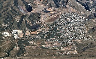
St. Johns is the county seat of Apache County, Arizona, United States. It is located along U.S. Route 180, mostly west of where that highway intersects with U.S. Route 191. As of the 2010 census, the population of the city was 3,480.

<span class="mw-page-title-main">Claypool, Arizona</span> CDP in Gila County, Arizona

Claypool is a census-designated place (CDP) in Gila County, Arizona, United States. The population was 1,538 at the 2010 census, down from 1,794 at the 2000 census. It was named after W. D. Claypool, a member of both the State House of Representatives and State Senate in the 1910s and 1920s.

<span class="mw-page-title-main">Morenci, Arizona</span> CDP in Greenlee County, Arizona

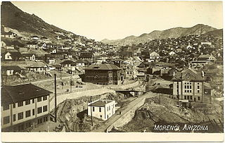
Morenci is a census-designated place (CDP) and company town in Greenlee County, Arizona, United States, and was founded by the Detroit Copper Mining Company of Arizona. The population was 2,000 at the 2000 census and 1,489 at the 2010 census. The biggest employer in Morenci and the owner of the town is Freeport-McMoRan, the owner of the Morenci Mine, the largest copper mining operation in North America, and one of the largest copper mines in the world. The town was a site of the Arizona Copper Mine Strike of 1983. The large open-pit mine is north of the town.

<span class="mw-page-title-main">Apache Junction, Arizona</span> City in Arizona, United States

Apache Junction is a city in Pinal and Maricopa County, Arizona, United States. As of the 2020 census, the population was 38,499, most of whom lived in Pinal County. It is named for the junction of the Apache Trail and Old West Highway. The area where Apache Junction is located used to be known as Youngberg. Superstition Mountain, the westernmost peak of the Superstition Mountains, is to the east.

<span class="mw-page-title-main">Golden Valley, Arizona</span> CDP in Mohave County, Arizona

Golden Valley is an unincorporated area and census-designated place (CDP) in Mohave County, Arizona, United States. The population was 8,801 at the 2020 census.

<span class="mw-page-title-main">Cibecue, Arizona</span> Fort Apache Indian Reservation community

Cibecue is a census-designated place (CDP) in Navajo County, Arizona, United States, on the Fort Apache Indian Reservation. The population was 1,713 in the 2010 United States Census.

<span class="mw-page-title-main">Snowflake, Arizona</span> Town in Navajo County, Arizona, U.S.

Snowflake is a town in Navajo County, Arizona, United States. It was founded in 1878 by Erastus Snow and William Jordan Flake, Mormon pioneers. Snowflake is 25 miles (40 km) south of Interstate 40 via Highway 77. The Apache Railway provides freight service.

<span class="mw-page-title-main">Taylor, Arizona</span> Town in Navaho County, Arizona

Taylor is a town in Navajo County, Arizona, United States. It was founded by Mormon settlers in January 1878, several months before the neighboring community of Snowflake. Taylor straddles Silver Creek, flowing from the nearby White Mountains to the Little Colorado River on Arizona's Colorado Plateau. According to the 2010 census, the population of the town is 4,112. The town was named for John Taylor, the third president of the Church of Jesus Christ of Latter-day Saints.

<span class="mw-page-title-main">Whiteriver, Arizona</span> Census designated place in Arizona, United States

Whiteriver is a census-designated place (CDP) located on the Fort Apache Indian Reservation in Navajo County, Arizona, United States. The population was 4,104 at the 2010 census, making it the largest settlement on the Reservation.

<span class="mw-page-title-main">Superior, Arizona</span> Town in Pinal County, Arizona

Superior is a town in Pinal County, Arizona, United States. Superior, which is in northern Pinal County, is the oldest town in that county. According to the 2020 census, the population of the town was 2,407. Superior was founded as a mining town for the Silver King and the later Magma mines; silver was mined at first, and then transitioned to copper. Currently, exploitation of the huge Resolution Copper deposit is being explored.

<span class="mw-page-title-main">Camp Verde, Arizona</span> Town in Yavapai County, Arizona

Camp Verde is a town in Yavapai County, Arizona, United States. As of the 2010 census, the population of the town is 10,873.

<span class="mw-page-title-main">Greer, Arizona</span> CDP in Apache County, Arizona

Greer is an unincorporated community and census-designated place in Apache County, Arizona, United States. Located within the White Mountains of Arizona and surrounded by the Apache-Sitgreaves National Forest, Greer is the highest town in the state at an elevation of approximately 8,400 feet. As of the 2020 census it had a population of 58. Greer was founded circa 1879 by Mormon settlers from Utah. The Greer post office has the ZIP code of 85927.

References

  1. "2020 U.S. Gazetteer Files". United States Census Bureau. Retrieved October 29, 2021.
  2. 1 2 U.S. Geological Survey Geographic Names Information System: Eagar, Arizona
  3. 1 2 "Geographic Identifiers: 2010 Demographic Profile Data (G001): Eagar town, Arizona". U.S. Census Bureau, American Factfinder. Archived from the original on February 12, 2020. Retrieved April 16, 2013.
  4. Andrew Jensen. Encyclopedic History of the Church. (Salt Lake City: Deseret News Press, 1941) p. 202
  5. 1 2 Byrd H. Granger (1960). Arizona Place Names . University of Arizona Press. p.  10 . Retrieved November 20, 2011.
  6. "Eagar, Arizona White Mountains". White Mountains Online. Retrieved February 3, 2017.
  7. Climate Summary for Eagar, Arizona
  8. "PRISM Climate Group at Oregon State University". Northwest Alliance for Computational Science & Engineering (NACSE), based at Oregon State University. Retrieved March 14, 2023.
  9. "Census of Population and Housing". Census.gov. Retrieved June 4, 2016.
  10. "U.S. Census website". United States Census Bureau . Retrieved January 31, 2008.
  11. https://www.apachecountylibraries.com/round-valley-public-library Apache County Library District. Retrieved on January 30, 2011.
  12. Town of Eagar
  13. Miner, Carrie. Off the Beaten Path Arizona: A Guide to Unique Places. p79. Google Books: