
McKinley County is a county in the northwestern section of the U.S. state of New Mexico. As of the 2020 United States Census, the population was 71,367. Its county seat is Gallup. The county was created in 1901 and named for President William McKinley.
Pinehill or Pine Hill is a census-designated place in Cibola County, New Mexico, United States. It is located on the Ramah Navajo Indian Reservation. The population was 88 at the 2010 census. The location of the CDP in 2010 had become the location of the Mountain View CDP as of the 2020 census, while a new CDP named "Pinehill" was listed 8 miles (13 km) further south, at a point 4 miles (6 km) southeast of Candy Kitchen.

Ramah is a census-designated place (CDP) in McKinley County, New Mexico. The population was 407 at the time of 2000 census and 370 at the 2010 United States Census.

Zuni Pueblo is a census-designated place (CDP) in McKinley County, New Mexico, United States. The population was 6,302 as of the 2010 Census. It is inhabited largely by members of the Zuni people.

The Zuni are Native American Pueblo peoples native to the Zuni River valley. Today, the Zuni are a Federally recognized tribe and most live in the Pueblo of Zuni on the Zuni River, a tributary of the Little Colorado River, in western New Mexico, United States. The Pueblo of Zuni is 55 km (34 mi) south of Gallup, New Mexico. The Zuni tribe lived in multi level adobe houses. In addition to the reservation, the tribe owns trust lands in Catron County, New Mexico, and Apache County, Arizona. The Zuni call their homeland Halona Idiwan’a or Middle Place. The word Zuni is believed to derive from the Western Keres language (Acoma) word sɨ̂‧ni, or a cognate thereof.
Cibola most commonly refers to:
Native Americans have inhabited what is now Arizona for thousands of years. It remains a state with one of the largest percentages of Native Americans in the United States, and has the second largest total Native American population of any state. In addition, the majority of the Navajo Nation, the largest Native American reservation in the US, and the entire Tohono O'odham Nation, the second largest, are located in Arizona. Over a quarter of the area of the state is reservation land.

The Zuni (Zuñi) River is a tributary of the Little Colorado River in the southwestern United States. It has its origin in Cibola County, New Mexico, in the Zuñi Mountains at the Continental Divide. The river flows off the western slopes of the Zuñi Mountains in a generally southwesterly direction through the Zuni Indian Reservation to join the Little Colorado River in eastern Arizona. The Zuni River is approximately 90 miles (140 km) long, and has a drainage basin in New Mexico of approximately 1,300 square miles (3,400 km2).
Grants/Cibola County Schools is a school district based in Grants, New Mexico, United States.
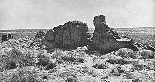
Hawikuh, was one of the largest of the Zuni pueblos at the time of the Spanish entrada. It was founded around 1400 AD. It was the first pueblo to be visited and conquered by Spanish explorers.

The Zuñi Mountains are a mountain range located mainly in Cibola County of northwestern New Mexico, United States, with a small portion extending into McKinley County. The range is located largely in the Cibola National Forest, lying south of Interstate 40 from southeast of Gallup to southwest of Grants. The range is about sixty miles (97 km) long and forty miles (64 km) wide. The highest point is Mount Sedgwick, 9,256 feet ; elevations in the range go down to 6,400 feet.

The Ramah Navajo Indian Reservation is a non-contiguous section of the Navajo Nation lying in parts of west-central Cibola and southern McKinley counties in New Mexico, United States, just east and southeast of the Zuni Indian Reservation. It has a land area of 230.675 sq mi (597.445 km²), over 95 percent of which is designated as off-reservation trust land. According to the 2000 census, the resident population is 2,167 persons. The Ramah Reservation's land area is less than one percent of the Navajo Nation's total area.
Gallup-McKinley County Schools (GMCS) is a school district based in Gallup, New Mexico which serves students from Gallup and surrounding areas of McKinley County.

The Zuni-Cibola Complex is a collection of prehistoric and historic archaeological sites on the Zuni Pueblo in western New Mexico. It comprises Hawikuh, Yellow House, Kechipbowa, and Great Kivas, all sites of long residence and important in the early Spanish colonial contact period. It was declared a National Historic Landmark District in 1974. These properties were considered as major elements of a national park, but the proposal was ultimately rejected by the Zuni people.
Zuni Public School District (ZPSD) is a school district headquartered in the Zuni Pueblo census-designated place of unincorporated McKinley County, New Mexico, United States.
Arizona, a state in the southwestern region of the United States of America, is known for its high population of Native Americans. Arizona has the third highest number of Native Americans of any state in the Union. Out of the entire US population of 2.9 million Native Americans, roughly 286,680 live in Arizona, representing 10% of the country's total Native American population. Only California and Oklahoma have more Native Americans than Arizona by number. Arizona also has the highest proportion of land allocated to Native American reservations, at 28%. Arizona has five of the twelve largest Indian reservations in the United States, including the largest, the Navajo Nation, and the third-largest, the Tohono O'odham Nation. Also, Arizona has the largest number of Native American language speakers in the United States.

Prewitt is an unincorporated community and census-designated place in McKinley County, New Mexico, United States. Prewitt is located along Interstate 40, 18 miles (29 km) northwest of Grants. Prewitt has a post office with ZIP code 87045.
The Halona Pueblo, also known as Zuni Pueblo, is located 36 miles south of Gallup, New Mexico on NM 32 & NM 53.
Zuni High School (ZHS) is a public high school in Black Rock, New Mexico, with a Zuni Pueblo postal address. It is a part of the Zuni Public School District.


