Rehoboth, New Mexico

Last updated
Rehoboth, New Mexico
Unincorporated community
USA New Mexico location map.svg
Red pog.svg
Rehoboth, New Mexico
Coordinates: 35°31′44″N108°39′17″W / 35.52889°N 108.65472°W / 35.52889; -108.65472 Coordinates: 35°31′44″N108°39′17″W / 35.52889°N 108.65472°W / 35.52889; -108.65472
Country United States
State New Mexico
County McKinley
Elevation 6,581 ft (2,006 m)
Time zone Mountain (MST) (UTC-7)
  Summer (DST) MDT (UTC-6)
ZIP code 87322
Area code(s) 505
GNIS feature ID 902843 [1]

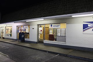
Rehoboth is an unincorporated community in McKinley County, New Mexico, United States. [1] Rehoboth is located along Interstate 40 5 miles (8.0 km) east of downtown Gallup. Rehoboth has a post office with ZIP code 87322. [2] [3] The Rehoboth Christian School is located in Rehoboth. it has a population of 56 permanent residents.

Unincorporated area Region of land not governed by own local government

In law, an unincorporated area is a region of land that is not governed by a local municipal corporation; similarly an unincorporated community is a settlement that is not governed by its own local municipal corporation, but rather is administered as part of larger administrative divisions, such as a township, parish, borough, county, city, canton, state, province or country. Occasionally, municipalities dissolve or disincorporate, which may happen if they become fiscally insolvent, and services become the responsibility of a higher administration. Widespread unincorporated communities and areas are a distinguishing feature of the United States and Canada. In most other countries of the world, there are either no unincorporated areas at all, or these are very rare; typically remote, outlying, sparsely populated or uninhabited areas.

McKinley County, New Mexico County in the United States

McKinley County is a county in the northwestern section of the U.S. state of New Mexico. As of the 2010 census, the population was 71,492. Its county seat is Gallup. The county was created in 1901 and named for President William McKinley.

New Mexico State of the United States of America

New Mexico is a state in the Southwestern region of the United States of America; its capital and cultural center is Santa Fe, which was founded in 1610 as capital of Nuevo México, while its largest city is Albuquerque with its accompanying metropolitan area. It is one of the Mountain States and shares the Four Corners region with Utah, Colorado, and Arizona; its other neighboring states are Oklahoma to the northeast, Texas to the east-southeast, and the Mexican states of Chihuahua to the south and Sonora to the southwest. With a population around two million, New Mexico is the 36th state by population. With a total area of 121,592 sq mi (314,920 km2), it is the fifth-largest and sixth-least densely populated of the 50 states. Due to their geographic locations, northern and eastern New Mexico exhibit a colder, alpine climate, while western and southern New Mexico exhibit a warmer, arid climate.

Related Research Articles

A ZIP Code is a postal code used by the United States Postal Service (USPS) in a system it introduced in 1963. The term ZIP is an acronym for Zone Improvement Plan; it was chosen to suggest that the mail travels more efficiently and quickly when senders use the code in the postal address. The basic format consists of five digits. An extended ZIP+4 code was introduced in 1983 which includes the five digits of the ZIP Code, followed by a hyphen and four additional digits that reference a more specific location.

Deerfield, New Jersey Unincorporated community in New Jersey, United States

Deerfield is an unincorporated community located within Upper Deerfield Township, Cumberland County, New Jersey, United States. Deerfield is located on New Jersey Route 77 6.6 miles (10.6 km) north of Bridgeton. Deerfield has a post office with ZIP code 08313; the post office uses the Deerfield Street name.

Arcola, Pennsylvania Unincorporated community in Pennsylvania, United States

Arcola is an unincorporated community in Upper Providence Township, Montgomery County, Pennsylvania, United States. Arcola is located on Perkiomen Creek 6.5 miles (10.5 km) west-northwest of Norristown. Arcola has a post office with ZIP code 19420, which opened on June 4, 1889.

North, Virginia Unincorporated community in Virginia, United States

North is an unincorporated community in Mathews County, Virginia, United States. North is located on Virginia State Route 14 4.75 miles (7.64 km) west of Mathews. North has a post office with ZIP code 23128.

Kimper, Kentucky Unincorporated community in Kentucky, United States

Kimper is an unincorporated community in Pike County, Kentucky. Kimper is located at the junction of Kentucky Route 194 and Kentucky Route 632, 9.3 miles (15.0 km) east of Pikeville. Kimper has a post office with ZIP code 41539, which opened on August 8, 1919.

Big Creek, Kentucky Unincorporated community in Kentucky, United States

Big Creek is an unincorporated community in Clay County, Kentucky, United States. Big Creek is located on U.S. Route 421, 10.7 miles (17.2 km) east of Manchester. Big Creek has a post office with ZIP code 40914.

Laughlintown, Pennsylvania Unincorporated community in Pennsylvania, US

Laughlintown is an unincorporated community in Ligonier Township, Westmoreland County, Pennsylvania, United States. Laughlintown is located on U.S. Route 30 3 miles (4.8 km) southeast of Ligonier. Laughlintown has a post office with ZIP code 15655, which opened on May 16, 1825.

Alton, Alabama Unincorporated community in Alabama, United States

Alton is an unincorporated community in Jefferson County, Alabama, United States. Alton is located along Interstate 459, 10 miles (16 km) east-northeast of downtown Birmingham. Alton has a post office with ZIP code 35015.

Baptistown, New Jersey Unincorporated community in New Jersey, United States

Baptistown is an unincorporated community located within Kingwood Township, in Hunterdon County, New Jersey, United States. Baptistown is located on New Jersey Route 12, approximately three miles (4.8 km) east of Frenchtown. The township's municipal offices are located in Baptistown just north of the center of the community.

Little York, Hunterdon County, New Jersey Unincorporated community in New Jersey, United States

Little York is an unincorporated community located along the border of Alexandria and Holland townships in Hunterdon County, New Jersey, United States. Little York is located on County Route 614 3.1 miles (5.0 km) north-northeast of Milford. Little York has a post office with ZIP code 08834.

Greendell, New Jersey Unincorporated community in New Jersey, United States

Greendell is an unincorporated community located within Green Township, in Sussex County, New Jersey, United States. Greendell is 4.2 miles (6.8 km) west of Andover. Greendell has a post office with ZIP code 07839.

Ironia, New Jersey Unincorporated community in New Jersey, United States

Ironia is an unincorporated community located within Randolph Township, in Morris County, New Jersey, United States. Ironia is 5.4 miles (8.7 km) southwest of Dover. Ironia has a post office with ZIP code 07845.

Middleville, New Jersey Unincorporated community in New Jersey, United States

Middleville is an unincorporated community located within Stillwater Township, in Sussex County, New Jersey, United States. Middleville is 5.8 miles (9.3 km) west of Newton. Middleville has a post office with ZIP code 07855.

Swartswood, New Jersey Unincorporated community in New Jersey, United States

Swartswood is an unincorporated community located on the border of Hampton and Stillwater townships in Sussex County, New Jersey, United States. Swartswood is 4.4 miles (7.1 km) west-northwest of Newton. Swartswood has a post office with ZIP code 07877.

Grenloch, New Jersey Unincorporated community in New Jersey, United States

Grenloch is an unincorporated community located within Washington Township, Gloucester County, New Jersey, United States. Grenloch is located along New Jersey Route 168 10.25 miles (16.50 km) south-southeast of Camden. Grenloch has a post office with ZIP code 08032.

South Seaville, New Jersey Unincorporated community in New Jersey, United States

South Seaville is an unincorporated community located within Dennis Township in Cape May County, New Jersey, United States. South Seaville is 4 miles (6.4 km) northwest of Sea Isle City. South Seaville has a post office with ZIP code 08246.

Milmay, New Jersey Unincorporated community in New Jersey, United States

Milmay is an unincorporated community located within Buena Vista Township, in Atlantic County, New Jersey, United States.

Norma, New Jersey Unincorporated community in New Jersey, United States

Norma is an unincorporated community located within Pittsgrove Township in Salem County, New Jersey, United States. Norma is located at the junction of County Routes 540 and 638, west of Vineland. Norma has a post office with ZIP code 08347, which opened on June 29, 1888.

Bosque, New Mexico Unincorporated community in New Mexico, United States

Bosque is an unincorporated community in Valencia County, New Mexico, United States. Bosque is located at the junction of New Mexico State Road 116 and New Mexico State Road 346 7.1 miles (11.4 km) south of Belen. Bosque has a post office with ZIP code 87006.

Eaton Park, Florida Unincorporated community in Florida, United States

Eaton Park is an unincorporated community in Polk County, Florida, United States. Eaton Park is located on U.S. Route 98, 3.3 miles (5.3 km) southeast of Lakeland. Eaton Park has a post office with ZIP code 33840.

References