Fence Lake, New Mexico

Last updated

Fence Lake, New Mexico
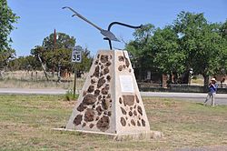
Fence Lake Monument.jpg
In front of the old school building
USA New Mexico location map.svg
Red pog.svg
Fence Lake
Coordinates: 34°39′12″N108°40′26″W / 34.65333°N 108.67389°W / 34.65333; -108.67389
Country United States
State New Mexico
County Cibola
Area
[1]
  Total
3.00 sq mi (7.77 km2)
  Land3.00 sq mi (7.77 km2)
  Water0.00 sq mi (0.00 km2)
Elevation
[2]
7,051 ft (2,149 m)
Population
 (2020) [3]
  Total
17
  Density5.66/sq mi (2.19/km2)
Time zone UTC-7 (Mountain (MST))
  Summer (DST) UTC-6 (MDT)
ZIP code
87315
Area code 505
FIPS code 35-26010
GNIS feature ID2584100 [2]

Fence Lake is a census-designated place located in southwestern Cibola County, New Mexico, United States. Designated in 1980 by the United States Census Bureau, Fence Lake had a population of 42 as of the 2010 census. [4] The area is largely ranchland, and there are few businesses there. It was named after a small village which is contained within its boundaries.

Contents

Geography

Fence Lake is located along New Mexico State Road 36, 33 miles (53 km) south of NM 53. It is 63 miles (101 km) south of Gallup and 40 miles (64 km) northwest of Quemado.

Climate

Climate data for Fence Lake, New Mexico (1991–2020)
MonthJanFebMarAprMayJunJulAugSepOctNovDecYear
Mean daily maximum °F (°C)46.0
(7.8)
50.5
(10.3)
58.1
(14.5)
66.2
(19.0)
75.8
(24.3)
84.9
(29.4)
86.3
(30.2)
83.2
(28.4)
78.9
(26.1)
67.9
(19.9)
55.5
(13.1)
46.2
(7.9)
66.6
(19.2)
Daily mean °F (°C)30.9
(−0.6)
35.1
(1.7)
41.2
(5.1)
47.0
(8.3)
55.3
(12.9)
64.4
(18.0)
69.1
(20.6)
67.1
(19.5)
61.4
(16.3)
50.0
(10.0)
38.4
(3.6)
30.8
(−0.7)
49.2
(9.6)
Mean daily minimum °F (°C)15.8
(−9.0)
19.7
(−6.8)
24.3
(−4.3)
27.8
(−2.3)
34.8
(1.6)
43.8
(6.6)
51.9
(11.1)
50.9
(10.5)
44.0
(6.7)
32.2
(0.1)
21.3
(−5.9)
15.5
(−9.2)
31.8
(−0.1)
Average precipitation inches (mm)0.87
(22)
0.71
(18)
0.75
(19)
0.45
(11)
0.43
(11)
0.45
(11)
2.12
(54)
2.44
(62)
1.73
(44)
1.09
(28)
0.79
(20)
0.76
(19)
12.59
(319)
Average snowfall inches (cm)6.4
(16)
2.7
(6.9)
4.5
(11)
0.9
(2.3)
0.0
(0.0)
0.0
(0.0)
0.0
(0.0)
0.0
(0.0)
0.0
(0.0)
1.6
(4.1)
2.5
(6.4)
4.7
(12)
23.3
(58.7)
Source: NOAA [5]

Post office

There is a post office located in the village of Fence Lake, serving the zip code 87315.

Demographics

Historical population
CensusPop.Note
2020 17
U.S. Decennial Census [6] [3]

As of the 2010 census, the population of the Fence Lake CDP was 42, consisting of 23 households, of which 11 were families. Females were 54.8% of the population. The racial make-up of the CDP was 26.2% Native American, 71.4% White, and 2.4% Asian. Hispanic or Latino of any race was 4.8% of the population. [7]

Education

The area is within the Quemado Schools school district. [8]

Aggressive Christianity Missionary Training Corps

Shim Ra Na Ekklisia (also called Miracle River) [9] is located near Fence Lake. It is a small community of Christians about 10 miles (16 km) to the east of the town. In July 1997, Deborah and Jim Green purchased 640 acres (260 ha), originally parts of the old Tingle Ranch at that location from Jonnie Head Real Estate. The Greens use the Fence Lake Post Office to mail out their publications.

See also

References

  1. "ArcGIS REST Services Directory". United States Census Bureau. Retrieved October 12, 2022.
  2. 1 2 U.S. Geological Survey Geographic Names Information System: Fence Lake, New Mexico
  3. 1 2 "Census Population API". United States Census Bureau. Retrieved October 12, 2022.
  4. "Geographic Identifiers: 2010 Demographic Profile Data (G001): Fence Lake CDP, New Mexico". U.S. Census Bureau, American Factfinder. Archived from the original on February 12, 2020. Retrieved October 20, 2014.
  5. "NOAA NCEI U.S. Climate Normals Quick Access". NOAA. Retrieved April 2, 2025.
  6. "Census of Population and Housing". Census.gov. Retrieved June 4, 2016.
  7. "Profile of General Population and Housing Characteristics: 2010 Demographic Profile Data (DP-1): Fence Lake CDP, New Mexico". U.S. Census Bureau, American Factfinder. Archived from the original on February 12, 2020. Retrieved October 20, 2014.
  8. "2020 CENSUS - SCHOOL DISTRICT REFERENCE MAP: Cibola County, NM" (PDF). U.S. Census Bureau . Retrieved July 12, 2022.
  9. Aggressive Christianity-Home of Shim Ra Na Holy Tribal Nation