
Mora County is a county in the U.S. state of New Mexico. As of the 2020 census, the population was 4,189. Its county seat is the census-designated place (CDP) Mora. The county has another CDP, Watrous, a village, Wagon Mound, and 12 smaller unincorporated settlements. Mora became a formal county in the US, in what was then the New Mexico Territory, on February 1, 1860. Ecclesiastically, the county is within the Roman Catholic Archdiocese of Santa Fe. County population peaked at approximately 14,000 circa 1920, declining to about 4,000 to 5,000 since the 1970s; the 2018 estimate was 4,506.

Cibola County is a county in the U.S. state of New Mexico. As of the 2020 census, the population was 27,172. Its county seat is Grants. It is New Mexico's youngest county, and the third youngest county in the United States, created on June 19, 1981, from the westernmost four-fifths of the formerly much larger Valencia County.
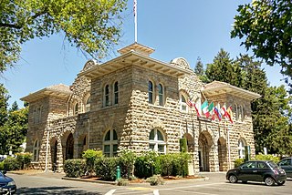
Sonoma is a city in Sonoma County, California, United States, located in the North Bay region of the San Francisco Bay Area. Sonoma is one of the principal cities of California's Wine Country and the center of the Sonoma Valley AVA. Sonoma's population was 10,739 as of the 2020 census, while the Sonoma urban area had a population of 32,679. Sonoma is a popular tourist destination, owing to its Californian wineries, noted events like the Sonoma International Film Festival, and its historic center.

Jicarilla Apache, one of several loosely organized autonomous bands of the Eastern Apache, refers to the members of the Jicarilla Apache Nation currently living in New Mexico and speaking a Southern Athabaskan language. The term jicarilla comes from Mexican Spanish meaning "little basket", referring to the small sealed baskets they used as drinking vessels. To neighboring Apache bands, such as the Mescalero and Lipan, they were known as Kinya-Inde.

Fort Wingate was a military installation near Gallup, New Mexico, United States. There were two other locations in New Mexico called Fort Wingate: Seboyeta, New Mexico (1849–1862) and San Rafael, New Mexico (1862–1868). The most recent Fort Wingate (1868–1993) was established at the former site of Fort Lyon, on Navajo territory, initially to control and "protect" the large Navajo tribe to its north. The Fort at San Rafael was the staging point for the Navajo deportation known as the Long Walk of the Navajo. From 1870 onward the garrison near Gallup was concerned with Apaches to the south, and through 1890 hundreds of Navajo Scouts were enlisted at the fort.
The term Navajo Wars covers at least three distinct periods of conflict in the American West: the Navajo against the Spanish ; the Navajo against the Mexican government ; and the Navajo against the United States. These conflicts ranged from small-scale raiding to large expeditions mounted by governments into territory controlled by the Navajo. The Navajo Wars also encompass the widespread raiding that took place throughout the period; the Navajo raided other tribes and nearby settlements, who in return raided into Navajo territory, creating a cycle of raiding that perpetuated the conflict.
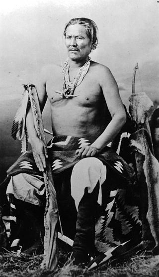
Chief Manuelito or Hastiin Chʼil Haajiní was one of the principal headmen of the Diné people before, during and after the Long Walk Period. Manuelito is the diminutive form of the name Manuel, the Iberian variant of the name Immanuel; Manuelito translates to Little Immanuel. He was born to the Bit'ahnii or ″Folded Arms People Clan″, near the Bears Ears in southeastern Utah about 1818. As many Navajo, he was known by different names depending upon context. He was Ashkii Diyinii, Dahaana Baadaané, Hastiin Ch'ilhaajinii and as Nabááh Jiłtʼaa to other Diné, and non-Navajo nicknamed him "Bullet Hole".

Mount Taylor is a dormant stratovolcano in northwest New Mexico, northeast of the town of Grants. It is the high point of the San Mateo Mountains and the highest point in the Cibola National Forest.
The Navajo are a Native American people of the Southwestern United States.

The Ute Mountain Ute Tribe is one of three federally recognized tribes of the Ute Nation, and are mostly descendants of the historic Weeminuche Band who moved to the Southern Ute reservation in 1897. Their reservation is headquartered at Towaoc, Colorado on the Ute Mountain Ute Indian Reservation in southwestern Colorado, northwestern New Mexico and small sections of Utah.
Grants/Cibola County Schools is a school district based in Grants, New Mexico, United States.

Solomon Bibo was a German Yiddish trader in the American Old West who became governor of Acoma Pueblo, equivalent of the tribal chief. He was the only non-Native person ever to serve as a governor of the Acoma Pueblo.
Polvadera is an unincorporated community and census-designated place in Socorro County in central New Mexico, United States. It is located on the west bank of the Rio Grande, near the mouth of the Rio Salado, and on the western spur of El Camino Real de Tierra Adentro.

The Bureau of Indian Education (BIE), headquartered in the Main Interior Building in Washington, D.C., and formerly known as the Office of Indian Education Programs (OIEP), is a division of the U.S. Department of the Interior under the Assistant Secretary for Indian Affairs. It is responsible for the line direction and management of all BIE education functions, including the formation of policies and procedures, the supervision of all program activities, and the approval of the expenditure of funds appropriated for BIE education functions.
Juan Francisco Treviño was the Governor of Santa Fe de Nuevo México from 1675 to 1679. As governor, he persecuted the Pueblo Native Americans, causing the Pueblo Revolt against the Spanish settlers.
Aboriginal land title in New Mexico is unique among aboriginal title in the United States. Congressional legislation was passed to define such title after the United States acquired this territory following war with Mexico (1846–1848). But the Supreme Court of the New Mexico Territory and the United States Supreme Court held that the Nonintercourse Act did not restrict the alienability of Pueblo lands.
San Rafael is a census-designated place (CDP) in Cibola County, New Mexico, United States. As of the 2010 census it had a population of 933. Also known as "Bikyaya" or "El Gallo", it lies at an elevation of 6,470 feet (1,970 m) above sea level and is located in north-central Cibola County at. New Mexico State Road 53 passes through the community, leading north 3 miles (5 km) to Interstate 40 and 5 miles (8 km) to the center of Grants, the county seat.

The San Miguel del Vado Land Grant is one of the Spanish land grants in New Mexico. On November 24, 1794, 53 men submitted a petition for land and were granted temporary possession on November 24, 1794, pending satisfaction of prescribed criteria. A second grant was obtained by 58 men and their respective families on March 12, 1803. Two days later, the procedure was repeated at San José del Vado, 6 kilometres (3.7 mi) north of San Miguel del Vado, distributing farm land to an additional 47 heads of household, including two women.

Fernando Chacón was a Spanish soldier who served as a governor of Santa Fe de Nuevo México, modern day New Mexico, between 1794 and 1804. He was a Knight of the Order of Santiago.
Alberto Maynez was a lieutenant colonel who served as Governor of Santa Fe de Nuevo México between 1807 and 1808 and between 1814 and 1816.


