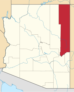
Wide Ruins, Arizona | |
---|---|
Coordinates: 35°25′02″N109°29′59″W / 35.41722°N 109.49972°W | |
Country | United States |
State | Arizona |
County | Apache |
Area | |
• Total | 0.39 sq mi (1.01 km2) |
• Land | 0.39 sq mi (1.01 km2) |
• Water | 0.00 sq mi (0.00 km2) |
Elevation | 6,273 ft (1,912 m) |
Population (2020) | |
• Total | 20 |
• Density | 51.15/sq mi (19.73/km2) |
Time zone | UTC-7 (MST) |
ZIP code | 86505 [3] |
Area code | 928 |
FIPS code | 04-82810 |
GNIS feature ID | 2582905 [2] |
Wide Ruins is a chapter of the Navajo Nation and a census-designated place (CDP) in Apache County, Arizona, United States. The population was 176 at the 2010 census. [4]
According to the United States Census Bureau, the CDP has a total area of 0.39 square miles (1.0 km2), all land. [4]
Jilłháál, or Jilhaal, whose name is not easily translated but refers to a war club, was an early 18th-century singer, warrior, and runner. As suggested in oral history and archaeology, he arrived at the Ganado–Wide Ruins area and traveled extensively. He lived among the Rio Grande Pueblo peoples and migrated with many of them to the refuge of Dinetah at the start of the Spanish invasion and occupation of present-day Arizona and New Mexico.
Jilhaal is believed to have brought many cultural, architectural, and agricultural influences to the greater Ganado-Wide Ruins region. Research suggests that Jilhaal contributed to the construction of fortifications to the north and south, notably in the hills east of Wide Ruins, 15 miles to the southeast of Ganado. Archaeologist David M. Brugge offers that Jilhaal "might have been a local headman of the mid-1770s, possibly a refugee from Awatobi, considering his clan (Táchiiʼnii) and his move to Black Mountain, a refuge of Tobacco Táchiiʼnii people from Awatobi." Oral history research suggests that he inhabited "Wide Ruins, (meaning the Ancestral Pueblo site) and, a few miles north up Wide Ruins Wash," at the citadel of Kin Naazinii (Upstanding House); if not contributed to its construction – with the help of elder Daalgai – "a Navajo fortified 'pueblito' that archaeologists date at 1720–1805 (NLC, site S-MLC-UP-L; Bannister and others 1966:8; Navajo Nation 1967:263, 271, 285; Gilpin 1996)." Thus, Jilhaal is believed to have traveled between here "north to Canyon de Chelly" regularly.
Oral histories tells of a Jilhaal who carried "gigantic arrows, and had enormous feet. The sight of his footprints struck terror in his enemies. Some say he was a hunter who could run down deer; others say he knew various healing and war ceremonies. Some say he was of the Red Streak into Water (Táchiiʼnii) clan and later moved to Black Mountain." His fame is embedded in oral history known to many Navajo families. "Some of his attributes may reflect late pre-Columbian iconography (big feet, for example, a common petroglyph motif). These pre-Columbian associations of Jilhaal, together with the idea that Wide Ruins was some kind of 'boundary' place between Hopi and Zuni zones ..., makes one wonder if the north-south travel corridor through Wide Ruins to Canyon de Chelly could have been a late 'everyone's land' as conceptualized by LaBlanc (1999:70, 333) between settlement clusters" much older. [5]
According to oral history, "Kin Naazinii was built as a fortress, with [defensive] slits in the walls for shooting arrows at enemies. People lived around the site and on top of the hill." The fortress was used as a citadel and "refuge when enemies were detected in the area. Some elders lived south of the site, including one named Daalgai, who helped build the fortifications" with Jilhaal. "Four stones deep were used (apparently meaning wall thickness). ... A passage underneath existed, "where one would crawl in and upward. This was the means of entry." It has since collapsed. "The defensive strategy was employed against "Utes and White Mountain Apaches. There was a goat corral in the rocks (or rincon?) below the fortress. The architecture provided good shield; modern in technology, it provided that those inside would not be a casualty by arrow shot. Hogans(homes) were constructed around the citadel for peace time use. Kin Naazinii Spring, located further up the canyon, was used as a water resource for the citadel. Oral legend suggest that a coyote had dug it out. At one point in the citadel's history, an ancient massacre occurred at Kin Naazinii. It is said that bones fragments were scattered around about the location, as well as leather, bridles, and other items. [5]
Scholars postulate that Kin Naazinii was positioned off circuitous routes from Zuni Pueblo to Hopi Mesa Pueblos, so that local Navajos could watch such travel without being seen. Surrounding hilltops provided views of the terrain that the ancient trails crossed.
Census | Pop. | Note | %± |
---|---|---|---|
2020 | 20 | — | |
U.S. Decennial Census [6] |
The Bureau of Indian Education (BIE)-affiliated tribal K-6 school Wide Ruin Community School is in the community. [7]
Sanders Unified School District is the local school district. [8]
The Puebloans, or Pueblo peoples, are Native Americans in the Southwestern United States who share common agricultural, material, and religious practices. Among the currently inhabited Pueblos, Taos, San Ildefonso, Acoma, Zuni, and Hopi are some of the most commonly known. Pueblo people speak languages from four different language families, and each Pueblo is further divided culturally by kinship systems and agricultural practices, although all cultivate varieties of maize.
Apache County is in the northeast corner of the U.S. state of Arizona. Shaped in a long rectangle running north to south, as of the 2020 census, its population was 66,021. The county seat is St. Johns.
Chinle is a census-designated place (CDP) in Apache County, Arizona, United States. The name in Navajo means 'flowing out' and is a reference to the location where the water flows out of the Canyon de Chelly. The population was 4,518 at the 2010 census.
Ganado is a chapter of the Navajo Nation and census-designated place (CDP) in Apache County, Arizona, United States. The population was 1,210 at the 2010 census.
Nazlini is a census-designated place (CDP) in Apache County, Arizona, United States. The population was 489 at the 2010 census. Nearby are Nazlini Creek and Nazlini Canyon. Nazlini Canyon is the site of many Native American ruins and campsites that were abandoned when erosion made them unusable.
Steamboat is a census-designated place (CDP) in Apache County, Arizona, United States, that includes Steamboat Canyon and Steamboat Trading Post. The population was 284 at the 2010 census.
Window Rock, known in Navajo as Tségháhoodzání, is a city and census-designated place that serves as the capital of the Navajo Nation, the largest Native American tribe by both land and tribal enrollment. The capital lies within the boundaries of the St. Michaels Chapter, adjacent to the Arizona and New Mexico state line. Window Rock is the site of the Navajo Nation governmental campus, which contains the Navajo Nation Council, Navajo Nation Supreme Court, the offices of the Navajo Nation President and Vice President, and many Navajo government buildings.
Indigenous peoples of Arizona are the Native American people who currently live or have historically lived in what is now the state of Arizona. There are 22 federally recognized tribes in Arizona, including 17 with reservations that lie entirely within its borders. Reservations make up over a quarter of the state's land area. Arizona has the third largest Native American population of any U.S. state.
Canyon de Chelly National Monument was established on April 1, 1931, as a unit of the National Park Service. Located in northeastern Arizona, it is within the boundaries of the Navajo Nation and lies in the Four Corners region. Reflecting one of the longest continuously inhabited landscapes of North America, it preserves ruins of the indigenous tribes that lived in the area, from the Ancestral Puebloans to the Navajo. The monument covers 83,840 acres and encompasses the floors and rims of the three major canyons: de Chelly, del Muerto, and Monument. These canyons were cut by streams with headwaters in the Chuska Mountains just to the east of the monument. None of the land is federally owned. Canyon de Chelly is one of the most visited national monuments in the United States.
Northern Arizona is an unofficial, colloquially-defined region of the U.S. state of Arizona. Generally consisting of Apache, Coconino, Mohave, Navajo, and Yavapai counties, the region is geographically dominated by the Colorado Plateau, the southern border of which in Arizona is called the Mogollon Rim.
The term Navajo Wars covers at least three distinct periods of conflict in the American West: the Navajo against the Spanish ; the Navajo against the Mexican government ; and the Navajo against the United States. These conflicts ranged from small-scale raiding to large expeditions mounted by governments into territory controlled by the Navajo. The Navajo Wars also encompass the widespread raiding that took place throughout the period; the Navajo raided other tribes and nearby settlements, who in return raided into Navajo territory, creating a cycle of raiding that perpetuated the conflict.
Navajo National Monument is a National Monument located within the northwest portion of the Navajo Nation territory in northern Arizona, which was established to preserve three well-preserved cliff dwellings of the Ancestral Puebloan people: Keet Seel, Betatakin, and Inscription House. The monument is high on the Shonto plateau, overlooking the Tsegi Canyon system, west of Kayenta, Arizona. It features a visitor center with a museum, three short self-guided trails, two small campgrounds, and a picnic area.
The Zuni Indian Reservation, also known as Pueblo of Zuni, is the homeland of the Zuni tribe of Native Americans. In Zuni language, the Zuni Pueblo people are referred to as A:shiwi, and the Zuni homeland is referred to as Halona Idiwan’a meaning Middle Place.
Polacca is an unincorporated community in Navajo County, of northeastern Arizona, United States. It is Hopi-Tewa community on the Hopi Reservation.
The Bureau of Indian Education (BIE), headquartered in the Main Interior Building in Washington, D.C., and formerly known as the Office of Indian Education Programs (OIEP), is a division of the U.S. Department of the Interior under the Assistant Secretary for Indian Affairs. It is responsible for the line direction and management of all BIE education functions, including the formation of policies and procedures, the supervision of all program activities, and the approval of the expenditure of funds appropriated for BIE education functions.
Art of the American Southwest is the visual arts of the Southwestern United States. This region encompasses Arizona, New Mexico, and parts of California, Colorado, Nevada, Texas, and Utah. These arts include architecture, ceramics, drawing, filmmaking, painting, photography, sculpture, printmaking, and other media, ranging from the ancient past to the contemporary arts of the present day.
The Defiance Plateau, part of the geologic Defiance Uplift, is an approximately 75-mile (121 km) long, mostly north-trending plateau of Apache County, Arizona, with its east and southeast perimeter, as parts of San Juan and McKinley Counties, New Mexico.
Cornfields is a chapter of the Navajo Nation and a census-designated place (CDP) in Apache County, Arizona, United States. The population was 255 at the 2010 census.
Bertha Pauline Dutton was an American anthropologist and ethnologist specializing in the American Southwest and Mesoamerica. She was one of the first female archeologists to work with the National Park Service.
The Indigenous peoples of the North American Southwest are those in the current states of Colorado, Arizona, New Mexico, Utah, and Nevada in the western United States, and the states of Sonora and Chihuahua in northern Mexico. An often quoted statement from Erik Reed (1666) defined the Greater Southwest culture area as extending north to south from Durango, Mexico to Durango, Colorado and east to west from Las Vegas, Nevada to Las Vegas, New Mexico. Other names sometimes used to define the region include "American Southwest", "Northern Mexico", "Chichimeca", and "Oasisamerica/Aridoamerica". This region has long been occupied by hunter-gatherers and agricultural people.
{{cite web}}
: CS1 maint: archived copy as title (link)