Snow comprises individual ice crystals that grow while suspended in the atmosphere—usually within clouds—and then fall, accumulating on the ground where they undergo further changes. It consists of frozen crystalline water throughout its life cycle, starting when, under suitable conditions, the ice crystals form in the atmosphere, increase to millimeter size, precipitate and accumulate on surfaces, then metamorphose in place, and ultimately melt, slide or sublimate away.

Lake-effect snow is produced during cooler atmospheric conditions when a cold air mass moves across long expanses of warmer lake water. The lower layer of air, heated by the lake water, picks up water vapor from the lake and rises through colder air. The vapor then freezes and is deposited on the leeward (downwind) shores.
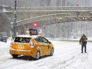
A winter storm is an event in which wind coincides with varieties of precipitation that only occur at freezing temperatures, such as snow, mixed snow and rain, or freezing rain. In temperate continental and subarctic climates, these storms are not necessarily restricted to the winter season, but may occur in the late autumn and early spring as well. A snowstorm with strong winds and other conditions meeting certain criteria is called a blizzard.
A winter storm warning is a hazardous weather statement issued by Weather Forecast Offices (WFO) of the National Weather Service (NWS) in the United States to alert the public that a winter storm is occurring or is about to occur in the area, usually within 36 hours of the storm's onset.
A winter weather advisory is a hazardous weather statement issued by local Weather Forecast Offices (WFO) of the National Weather Service in the United States when one or more types of winter precipitation—snow, rain and snow mixed, freezing rain, sleet, graupel, etc.—presenting a hazard, but not expected to produce accumulations meeting storm warning criteria, are forecast within 36 hours of the expected onset of precipitation or are occurring in the advisory's coverage area.

A snow squall, or snowsquall, is a sudden moderately heavy snowfall with blowing snow and strong, gusty surface winds. It is often referred to as a whiteout and is similar to a blizzard but is localized in time or in location and snow accumulations may or may not be significant.
Ice pellets or "sleet" is a form of precipitation consisting of small, hard, translucent balls of ice. Ice pellets are different from graupel, which is made of frosty white opaque rime, and from a mixture of rain and snow, which is a slushy liquid or semisolid. Ice pellets often bounce when they hit the ground or other solid objects, and make a higher-pitched "tap" when striking objects like jackets, windshields, and dried leaves, compared to the dull splat of liquid raindrops. Pellets generally do not freeze into other solid masses unless mixed with freezing rain. The METAR code for ice pellets is PL.
The city of Vancouver, located in British Columbia, Canada, has a temperate oceanic climate that borders on a warm-summer Mediterranean climate (Csb). Its summer months are typically dry, often resulting in moderate drought conditions, usually in July and August. In contrast, the rest of the year is rainy, especially between October and March.
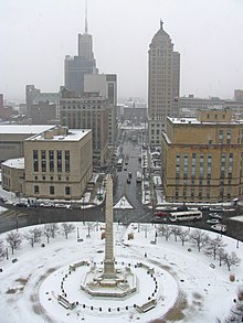
A lake effect snow warning is a bulletin issued by the National Weather Service in the United States to warn of heavy snowfall accumulations that are imminent from convective snow generated by very cold airmass passing over unfrozen lakes. The criteria for amounts may vary significantly over different county warning areas. On October 2, 2017, some National Weather Service Forecast Offices discontinued issuing the Lake Effect Snow Warning, and consolidated it with the Winter Storm Warning. On October 15, 2018, the National Weather Service discontinued issuing Lake Effect Snow Warnings nationwide all together, and all offices consolidated it with the Winter Storm Warning. Lake effect snow warnings were reinstated for the 2019–20 winter season.
The climate of Houston is classified as a humid subtropical climate, with tropical influences. August normally ranks as the warmest month at an average temperature of 84.6 °F (29.2 °C) and January the coldest month at an average temperature of 53.1 °F (11.7 °C).

It is very rare for snow to fall in the U.S. state of Florida, especially in the central and southern portions of the state. With the exception of the far northern areas of the state, most of the major cities in Florida have never recorded measurable snowfall, though trace amounts have been recorded, or flurries in the air observed few times each century. According to the National Weather Service, in the Florida Keys and Key West there is no known occurrence of snow flurries since the European colonization of the region more than 300 years ago. In Miami, Fort Lauderdale, and Palm Beach there has been only one known report of snow flurries observed in the air in more than 200 years; this occurred in January 1977. In any event, Miami, Fort Lauderdale, and Palm Beach have not seen snow flurries before or since this 1977 event.

A blizzard warning is a hazardous weather statement issued by Weather Forecast Offices (WFO) of the National Weather Service (NWS) in the United States, which indicates heavy snowfall accompanied by sustained winds or frequent gusts of 35 mph (56 km/h) or greater are forecast to occur for a minimum of three hours. A blizzard tends to reduce visibilities to 1⁄4 mile (400 m) or less.

Classifications of snow describe and categorize the attributes of snow-generating weather events, including the individual crystals both in the air and on the ground, and the deposited snow pack as it changes over time. Snow can be classified by describing the weather event that is producing it, the shape of its ice crystals or flakes, how it collects on the ground, and thereafter how it changes form and composition. Depending on the status of the snow in the air or on the ground, a different classification applies.

The winter of 2009–10 in the United Kingdom was a meteorological event that started on 16 December 2009, as part of the severe winter weather in Europe. January 2010 was provisionally the coldest January since 1987 in the UK. A persistent pattern of cold northerly and easterly winds brought cold, moist air to the United Kingdom with many snow showers, fronts and polar lows bringing snowy weather with it.

A snowboard (US) or weaverboard (Canada) is a meteorological tool used to aid in the obtaining of accurate measurement of snow accumulation.
The cold wave of January 1977 produced the only known trace of snow in the greater Miami area of Florida ever reported. It occurred following the passage of a strong cold front, in combination with a high-pressure area situated over the Mississippi River Valley. As a result, cold air moved far to the south across Florida, causing both snow flurries and record low temperatures. Most notably, the weather system brought snow flurries as far south as Homestead on January 19. No snow had ever been reported in southeastern Florida before or since. Damage was most significant to agriculture, as major losses occurred to citrus fruits and tender vegetables. Statewide, agricultural damage from the cold wave totaled to $350 million (1977 USD), and losses overall totaled to $2 billion (1977 USD). One fatality occurred due to an automobile accident in Central Florida, which was related to the cold wave.

The 2009–10 North American winter saw several major blizzards affect the Northeastern United States. It refers to winter as it occurred across the North American continent from late 2009 to early 2010. While there is no well-agreed-upon date used to indicate the start of winter in the Northern Hemisphere, there are two definitions of winter which may be used. Based on the astronomical definition, winter begins at the winter solstice, which in 2009 occurred on December 21, and ends at the March equinox, which in 2010 occurred on March 20. Based on the meteorological definition, the first day of winter is December 1 and the last day February 28. Both definitions involve a period of approximately three months, with some variability.

In meteorology, a trace denotes an amount of precipitation, such as rain or snow, that is greater than zero, but is too small to be measured by standard units or methods of measurement. The designation of a trace rather than zero is used to indicate that precipitation did fall, but not enough to be measured reliably. This is important for both weather forecasting and climatological purposes, because even precipitation amounts too small to be measured can have significant societal impacts.

The 2020–21 North American winter was the most significant winter season to affect North America in several years, and the costliest on record, with a damage total of at least $33.35 billion. The season featured 6 storms ranking on the Regional Snowfall Index scale, with 4 storms ranking as at least a Category 3. Most of the winter's damage and fatalities occurred due to a historic and major cold wave in mid-February. Several other significant events occurred, including a crippling early-season ice storm in the Southern Plains, a powerful nor'easter in mid-December, another major nor'easter in early February, two major and widespread winter storms in mid-February, and a major blizzard in the Rocky Mountains in mid-March. The winter-related events were responsible for at least 358 fatalities, making it the deadliest season since 1992–93. A La Niña pattern influenced much of the winter in North America.

The January 14–17, 2022 North American winter storm brought widespread impacts and wintry precipitation across large sections of eastern North America and parts of Canada. Forming out of a shortwave trough on January 13, it first produced a swath of snowfall extending from the High Plains to the Midwestern United States. The storm eventually pivoted east and impacted much of the Southern United States from January 15–16 before shifting north into Central Canada, the Mid-Atlantic states, and the Northeastern United States. The system, named Winter Storm Izzy by The Weather Channel, was described as a "Saskatchewan Screamer".