This glossary of meteorology is a list of terms and concepts relevant to meteorology and atmospheric science, their sub-disciplines, and related fields.
Describing a collection of low-lying, radially structured clouds with distinct shapes (resembling leaves or wheels in satellite imagery), and typically organized in extensive mesoscale fields over marine environments. They are closely related to and sometimes considered a variant of stratocumulus clouds.
The rate at which a parcel of air changes temperatureadiabatically as it moves vertically through the atmosphere. The parcel's moisture content affects this rate: as it rises, a parcel saturated with moisture cools more slowly than a dry parcel because the release of latent heat at the phase change between gas and liquid acts to buffer the temperature decrease caused by the adiabatic expansion.[2] When not otherwise qualified, the term most often refers to the dry adiabatic lapse rate.
Any idealized hypothetical process by which energy is transferred between a thermodynamic system and its surroundings only as work, without a corresponding transfer of heat or mass. Most compressible fluids, including gases in the atmosphere, behave approximately adiabatically, such that meteorologists often use the assumption of adiabatic isolation when describing atmospheric systems. In such systems the temperature of a dryparcel of air changes without any exchange of energy with its surroundings: as the parcel rises, the decrease in the surrounding atmospheric pressure enables the air in the parcel to expand in volume, which decreases its internal energy and therefore its temperature (expansional cooling); as the parcel sinks and is compressed, its temperature increases (compressional warming).[2]
The branch of biology that studies airborne organic particles, such as bacteria, viruses, fungal spores, pollen grains, and very small insects, which are passively transported by the air.
The branch of meteorology that studies the upper regions of the Earth's or other planetary atmospheres, specifically their atmospheric motions, chemical compositions and properties, and interactions with the other parts of the atmosphere and with space.
Any concentrated area of winds that develops because of differences in pressure and/or temperature between adjacent air parcels. They are generally divided into horizontal and vertical currents and exist at a variety of scales and in various layers of the atmosphere.
Any thunderstorm that is generally weak and usually not severe. Such storms move relatively slowly, are short-lived, and often exist only as single cells (rather than in long continuous lines or complexes), but may still produce lightning and heavy rainfall. They derive their energy from solar radiation and commonly develop in temperate zones during summer afternoons.
Located in the atmosphere at some height (often significantly high) above the Earth's surface. The term is typically used to distinguish an upper-air observation from a surface weather observation, as in "winds aloft".[3]
A middle-altitude cloud genus characterized by small globular masses, laminae, or rolls, white or gray in color, arranged in patches or extensive sheets at altitudes between 2 and 7 kilometres (6,600 and 23,000ft), with the individual elements being larger and more distinct than in cirrocumulus but smaller than in stratocumulus. Like other stratocumuliform clouds, altocumulus usually signifies convection aloft. It is one of several classic "warning clouds" recorded by the aviation industry as a signal of developing thunderstorms.
A scientific and professional organization in the United States whose mission is to promote and disseminate information about the atmospheric, oceanic, and hydrologic sciences, and advance technologies, applications, and services related to them.
A wind that blows upslope from the low elevations of a valley to the higher elevations of surrounding hills or mountains as the result of daytime surface heating in the valley, usually at speeds of 12 knots (22km/h; 14mph) or less but occasionally at much higher speeds.[3] Contrast katabatic wind.
Any large-scale air mass characterized by outward spiraling winds which circulate around a strong center of highatmospheric pressure. Surface-based anticyclones generally bring about cool, dry air and clear skies and are often implicated in weather phenomena such as fog and haze. Contrast cyclone.
Any storm system involving an anticyclone, in which winds circulate around a region of high pressure in the direction opposite to that expected around a region of low pressure. Anticyclonic storms rotate clockwise in the Northern Hemisphere and counterclockwise in the Southern Hemisphere.
The top of a cumulonimbus (Cb) is often flat and spreading, shaped like an anvil. Thunderstorm anvils are capable of spreading great distances away from the thunderstorm itself.[4]
The various layers of gases surrounding the Earth and held in place by gravity. The Earth's atmosphere is the origin of the weather phenomena studied in meteorology. Atmospheric composition, temperature, and pressure vary across a series of distinct sublayers including the troposphere and stratosphere.
The properties of Earth's atmosphere vary by altitude across a series of distinct layers.
The global-scale movement of air masses within the Earth's atmosphere. All meteorological phenomena are consequences of the atmospheric circulation, which manifests as a network of both latitudinal and longitudinal "cells" of convective activity; together with ocean circulation, these cells are the primary means by which thermal energy from the Sun is redistributed across the Earth's surface.
The pressure exerted by the Earth's atmosphere. In most circumstances atmospheric pressure is closely approximated by the hydrostatic pressure caused by the weight of the air above the measurement point, and therefore decreases proportionally as altitude increases. The average atmospheric pressure at sea level on Earth is equal to approximately 1 standard atmosphere (atm), which is defined as exactly 101,325 pascals (760mmHg).
The collective of scientific disciplines that studies the Earth's atmosphere and its processes, including the effects other systems have on the atmosphere and those the atmosphere has on other systems. Meteorology and climatology are sub-disciplines.
A measure of temperature at one or more locations within the Earth's atmosphere. Temperatures recorded in the atmosphere can vary widely with altitude, humidity, and solar irradiance, among other factors.
A global-scale periodic oscillation of the Earth's atmosphere caused by gravitational and thermal influences from the Sun and the Moon, analogous to oceanic tides.[5]
atmospheric window
Any of the ranges of small bandwidths in the electromagnetic spectrum at which the Earth's atmosphere is nearly transparent, i.e. where absorption by atmospheric gases is nearly zero and transmittance approaches unity both for incoming and outgoing radiation. Examples include the optical window from ~0.3 to 0.9 μm, the infrared window from ~8 to 13 μm, and the microwave window at wavelengths longer than ~1 mm.[5] The existence of these windows is vital for the Earth–atmosphere system to be maintained near thermal equilibrium.[2]
A former message product of the U.S. National Weather Service issued to provide information to pilots and aviation routes about weather conditions across a large regional area within the United States. FAs were issued three times daily, valid for 18 hours, and covered an area the size of several states. They were replaced by Graphic Area Forecasts (GFAs) in 2017.
B
backing
A change of wind direction in a counterclockwise fashion (e.g. northerly to northwesterly to westerly). Contrast veering.[3]
The diffuse reflection of waves, particles, or signals back to the same direction from which they originated. Backscattering is the principle underlying all weather radar systems, which can distinguish radar returns backscattered from target aerosols such as raindrops and snowflakes because the strength of the returns depends largely on the size and reflectivity of the targets.
Any segment of a larger geographic region that typically experiences warmer temperatures than the region as a whole, especially during the local winter season, which may prove favorable for agriculture.
A measure of the misalignment between a pressure gradient and a density gradient in a stratified fluid such as the atmosphere. In the context of meteorology, a baroclinic atmosphere is one in which atmospheric density depends on both temperature and pressure, in contrast to a barotropic atmosphere, in which density depends only on pressure. Areas of high atmospheric baroclinity are generally found in the temperate and polar latitudes and are characterized by the frequent formation of cyclones.
The close alignment between a pressure gradient and a density gradient in a stratified fluid such as the atmosphere. In the context of meteorology, a barotropic atmosphere is one in which atmospheric density depends only on pressure and is more or less independent of temperature, in contrast to a baroclinic atmosphere. Unlike liquids, gaseous fluids such as the air in the atmosphere are generally not barotropic, but the assumption of barotropity can nonetheless be useful in modeling fluid behavior. Tropical latitudes are more nearly barotropic than the mid-latitudes because air temperature is more nearly horizontally uniform in the tropics.
A low-level core of high wind speeds that sometimes occurs at altitudes of 1,000–1,500 metres (3,300–4,900ft) in the vicinity of a mountain range, as a consequence of the deceleration of an airflow as it crosses a major topographic barrier and releases latent heat which changes the local thermodynamics of the flow.[2]
A principle of fluid dynamics which states that an increase in the speed of a moving fluid occurs simultaneously with a decrease in the pressure exerted by the fluid or in the fluid's potential energy.
A thin, nearly transparent coating of glaze ice on a solid surface, especially a road or walkway, which because of its transparency is often practically invisible and therefore presents a significant hazard to drivers and pedestrians.
A severe snowstorm characterized by strong sustained winds of at least 35mph (56km/h) and blowing snow, typically lasting three hours or more. They can have an immense size, covering hundreds or thousands of square miles, and occur most often in temperate, polar, or mountainous regions during the winter.
A nearly stationary pattern in the atmospheric pressure field overlying a large geographic area, which effectively "blocks" or diverts the movements of cyclones and other convective systems. These blocks can remain in place for days or weeks, causing the areas affected by them to experience the same kind of weather for extended periods of time.
A lithometeor phenomenon that occurs when particles of dust are lifted from the Earth's surface by wind and blown about in clouds or sheets. It is classified as an obstruction to vision in METAR aviation weather observations and is commonly reported if the amount of suspended dust reduces horizontal visibility to 10 kilometres (6mi) or less.[3] Extreme cases may be called dust storms.[5]
A lithometeor phenomenon that occurs when grains of sand are lifted from the Earth's surface by wind and blown about in clouds or sheets. It is classified as an obstruction to vision in METAR aviation weather observations and is commonly reported if the amount of suspended sand reduces horizontal visibility to 10 kilometres (6mi) or less.[3] Extreme cases may be called sandstorms.[5]
Snow blown about by wind, either from falling snow or snow lifted from the surface, to a height of at least 2 metres (6.6ft), reducing visibility. It is a defining characteristic of blizzards.
A characteristic radar return from a mesoscale convective system that is shaped like an archer's bow and usually associated with squall lines or lines of convective thunderstorms. The distinct bow shape is a result of the focusing of a strong flow at the rear of the system. Especially strong bow echoes may develop into derechos.
A radar image showing a distinct bow echo in a line of thunderstorms over Kansas City, Missouri
3.On the Beaufort scale, a wind speed of force numbers 2 to 6, ranging from 4–27 knots (7–50km/h; 5–31mph), and categorized as follows: light breeze, 4–6 knots; gentle breeze, 7–10 knots; moderate breeze, 11–16 knots; fresh breeze, 17–21 knots; and strong breeze, 22–27 knots.[3]
A dimensionless ratio related to the consumption of turbulence divided by the shear production of turbulence (the generation of kinetic energy caused by wind shear). It is an approximation of the Gradient Richardson Number.
A state of the atmosphere in which there is virtually no horizontal motion of the air. It corresponds to force number 0 on the Beaufort scale, with a wind speed less than 1kn (1.9km/h). Calm conditions are common in the subtropical high-pressure belts and in the doldrums.[2]
The national society of individuals and organizations dedicated to advancing atmospheric and oceanic sciences and related environmental disciplines in Canada, officially constituted in 1967.
An approximately stationary cloud on or hovering above an isolated mountain peak. See also pileus and lenticular cloud.[3]
capacity
The ability of a wind current to transport material, as measured by the maximum amount of detritus (e.g. silt, sand, and/or gravel) carried past a specific point per unit time. Capacity increases with wind speed and decreases as the particle size of the detrital debris increases.[2]
A measure of the height above the Earth's surface of the base of the lowest layer of clouds or obscuring phenomena that covers more than half of the sky (more than four oktas). An "unlimited" ceiling means either that the sky is mostly free of cloud cover or that the clouds are sufficiently high so as not to impede aircraft operation by visual flight rules.
A type of weather balloon used by meteorologists to determine the height of the cloud baseabove ground level during daylight hours by measuring the time it takes for the balloon, released from the ground and rising at a known rate of ascent, to begin to disappear into the clouds.
An instrument that uses a laser transmitter or other light source and a collocated receiver to determine the height of a cloud ceiling or cloud base overhead, or to measure the concentration of aerosols within the atmosphere.
2.In weather radar, a local maximum in radar reflectivity that undergoes a life cycle of growth and decay, and which often displays an identifiable structure in radar returns. Cells in ordinary convective thunderstorms typically last 20 to 30 minutes, but may form longer-lasting multicell storms or supercells.[5]
cellular cloud
A mesoscale organization of convective activity in the form of a quasi-regular pattern of clouds behaving as individual convective cells, often stretching horizontally for tens of kilometers. Such patterns may be composed of open or closed cells or both: the open cells consisting of a ring of cumulus with a clear center, and the closed cells filled with stratocumulus surrounded by a clear rim.[3]
Develops techniques for computer-based prediction of high-impact local weather, such as individual spring and winter storms, using Doppler weather radar and other sources. Based in Oklahoma, United States.
The large, centralized, contiguous area of thunderstorms surrounding the rotational center of a strong tropical or subtropical cyclone. When a cyclone reaches sufficient intensity, a distinguishable eye may develop within the CDO. The strongest winds and heaviest rainfall are usually found beneath the coldest cloud tops in the CDO.
central pressure
The atmospheric pressure at the center of a recognizable high or low-pressure area at any given instant, i.e. the highest pressure in a high or the lowest pressure in a low.[3]
ceraunometer
An instrument used for counting the number of lightning discharges within a specific radius.[3]
A warm, dry föhn wind formed by a rainstorm dropping its precipitation onto the windward side of a mountain, thus drying the air mass before it blows across the leeward side, drops in elevation, and warms by adiabatic heating. Common in the northwestern United States and southwestern Canada, a chinook can cause temperatures to rise from −48°C (−54.4°F) to 9°C (48.2°F) in 24 hours, an increase of 57°C (103°F).
A genus of cloud with both stratiform and cumuliform characteristics, signifying atmospheric convection, and appearing as white, patchy, transient sheets of ripples or tufts organized in undulating rows, usually between 5 and 12km (16,000 and 39,000ft) above sea level. Though composed mainly of ice crystals, cirrocumulus is distinguished from cirrus and cirrostratus by the presence of small amounts of supercooled liquid water droplets.
A genus of cloud characterized by thin, wispy, feather-like strands that appear white or light grey in color and form at very high altitudes, usually between 5 and 13.7km (16,000 and 45,000ft) above sea level. Cirrus clouds often develop from the outflow of cumulonimbus clouds in advance of fronts or thunderstorms, and therefore may indicate the imminent arrival of precipitation.
A type of solid precipitation which forms when relatively large drops of water are supercooled into a dense, transparent coating of ice without air or other impurities. It is similar to glaze and hard rime and, when formed on the ground, is often called black ice.
A branch of the atmospheric sciences that studies climate, defined as weather conditions averaged over an extended to indefinite period of time. Climatology incorporates aspects of oceanography, geology, biogeochemistry, and the related field of meteorology to understand the long-term dynamics of climate-influencing phenomena and to produce climate models which can be used to estimate past climates and predict future climates.
An aerosol consisting of a visible mass of minute liquid droplets, frozen crystals or other particles suspended in the atmosphere. Water or various other chemicals may compose the droplets and crystals. On Earth, clouds are formed as a result of the saturation of an air mass when it is cooled to its dew point or when it gains sufficient moisture (usually in the form of water vapor) from an adjacent source to raise the dew point to the ambient temperature. There are many different types of clouds, which are classified and named according to their shape and altitude.
The obscuration of all or part of the sky by clouds as observed from a particular location, or the specific fraction of the sky obscured by clouds as measured in oktas.
A type of photometeor consisting of colorful iridescent patterns appearing most commonly near the semi-transparent edges of thin clouds such as cirrus and altocumulus that are in the general proximity of the Sun or Moon. They are caused by the diffraction of sunlight or moonlight by thin, uniform layers of very small water droplets or ice crystals.
Any of a set of 14 Latin terms used to describe the shape and internal structure of troposphericclouds. Cloud species are subdivisions of cloud genera and are themselves further subdivided into cloud varieties.
Any of a set of Latin names used to classify and identify clouds occurring in the troposphere, typically by characteristics such as their altitude, shape, and convective activity. A set of 10 or 12 traditional cloud types defined by the World Meteorological Organization and further subdivided into cloud species and cloud varieties is widely used in meteorology. Other classification systems have proposed many additional types.
A colloquial term used to describe an excessive precipitation event, characterized by brief, sudden, exceptionally heavy rain and/or hail falling from a cloud, typically as part of a thunderstorm associated with violent upward and downward convective currents.[2]
The point of intersection of a trough and a ridge in the pressure pattern of a weather map. It generally takes the shape of a saddle in which the air pressure is slightly higher than that within the low-pressure regions but still lower than that within the anticyclonic zones.
A type of front located at the leading edge of a cooler air mass as it replaces a warmer air mass. Cold fronts lie within a sharp surface trough of low pressure and the temperature difference between the air masses they separate can exceed 30°C (86°F). When enough moisture or instability is present, lines of rain or thunderstorms may accompany the boundary as it moves. In surface weather analysis, cold fronts are symbolized by a blue line with triangles pointing in the direction of travel.
A period of weather characterized by excessively low temperatures, which may or may not also be accompanied by changes in humidity. Very cold weather is often only referred to as a cold wave if the temperature, or the rate at which the temperature decreases within a given time period, is abnormal relative to the typical climate for a given location during a given season. Contrast heat wave.
The inability of an air mass to resist vertical motion. In a stable atmosphere vertical movement of air is generally difficult, whereas in an unstable atmosphere vertical disturbances can be quite exaggerated, resulting in turbulent airflow and convective activity that may lead to extensive vertical clouds, storms, and severe weather.
A pattern of fluid flow that brings about a net inflow of fluid elements into a region, in either the atmosphere or the ocean, accompanied by compensating vertical motion. When convergence occurs in the lower atmosphere, generally below about 550 hectopascals (0.54atm), the compensatory air motion is upward, with inflow gradually changing to outflow at higher altitudes; when it occurs in the upper atmosphere, the air motion is downward, with divergence near the surface.[2]
An optical phenomenon consisting of apparent concentric, pastel-colored rings around a bright celestial object (such as the Sun or the Moon), which are produced by the diffraction of light by individual water droplets or sometimes small ice crystals in a cloud or on a foggy glass surface. Coronae differ from halos in that the latter are formed by refraction from comparatively large particles.
An inviscid line-vortex instability most commonly observed in the skies behind large aircraft such as the Boeing 747. It occurs when the wingtip vortices interact with contrails from the engines, producing characteristic visual distortions in the shapes of the contrails.
A genus of cloud characterized by low-level "puffy" or "cotton-like" forms with flat bases (generally opaque white in color but sometimes with grey undersides), which occur individually or multiply in a variety of distinct subforms, usually at altitudes less than 2km (6,600ft) above sea level. Cumulus clouds normally produce little or no precipitation, but can develop into precipitation-bearing clouds such as cumulonimbus when influenced by atmospheric instability, moisture, and temperature gradients.
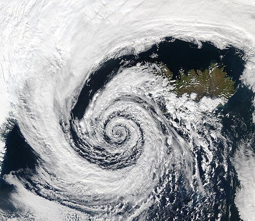
Very large air masses (and the clouds within them) spiral counterclockwise around a strong center of low atmospheric pressure in this extratropicalcyclone over Iceland
The development or strengthening of a cyclonic circulation in the atmosphere. Cyclogenesis may refer to a number of different processes that occur under a variety of conditions and at a variety of scales, all of which result in the formation of some sort of cyclone; for instance, tornadoes are a type of mesocyclone whose development may be variously described as cyclogenesis or, more specifically, tornadogenesis. Contrast anticyclogenesis.
A type of specialized eyewear used by meteorologists and astronomers for adapting the eyes to the dark prior to an observation made at night, or for aiding with identification of clouds during bright sunshine or when there is a glare from snow.
The period of the day between sunrise and sunset, during which any given point on the Earth experiences natural illumination from especially direct sunlight, known as daylight.
A decrease in the central and surrounding sea-level pressure within the circulation of a pressure system (usually a low-pressure system) over a short period of time, with the result that mass is exported from the total air column overlying the system faster than it is supplied. Deepening of a low is commonly accompanied by the intensification of its cyclonic circulation and hence its winds, and the term is frequently used to imply cyclogenesis.[2] Contrast filling.
The rate of change of shape of a fluid body such as an air mass. This quantity is very important in the formation of atmospheric fronts, in the explanation of cloud shapes, and in the diffusion of materials and properties through the atmosphere.
A measure of the difference between the mean daily temperature and a specified reference temperature for a given day. For a specified period, e.g. a month or a year, the number of degree-days is the sum of all degree-days within that period.[2]
An advisory issued by the U.S. National Weather Service to caution the public about the possibility that horizontal visibility may be reduced by dense fog to 0.25 miles (0.40km) or less.[3]
Any area of low atmospheric pressure at a given level in the atmosphere; i.e. a "low" or trough. The term is used especially frequently to refer to an early stage in the development of a tropical cyclone during which the disturbance is only weakly developed or poorly organized; see tropical depression.
Liquid water droplets that commonly appear on thin, exposed surfaces in the morning or evening due to the condensation of atmospheric moisture on radiatively cooled surfaces. When temperatures are low enough, the water droplets freeze into ice particles known as frost.
The temperature to which an air parcel must be cooled, at constant pressure and moisture content, in order for saturation to occur. Continued cooling below the dew point will cause condensation of water droplets if atmospheric conditions are favorable. Dew point is often used as a proxy by which to indicate the moisture content of the air.[2]
Any thermodynamic process in which the temperature of an air parcel changes as a result of the transfer of energy (e.g. heat) between the parcel and its surroundings, as opposed to an adiabatic process, in which the temperature changes without any such exchange. Most thermodynamic processes near the Earth's surface are diabatic, owing to the continual mixing of air and turbulence.[2]
A ground-level cloud composed of tiny ice crystals. Because it generally forms in sub-freezing temperatures beneath otherwise clear or nearly clear skies, diamond dust is sometimes referred to as clear-sky precipitation.
The component of incoming solar radiation that is scattered from the direct solar beam by molecules of air, aerosols, clouds, or particulate matter in the atmosphere and subsequently reaches the Earth's surface in nearly equal amounts from nearly all parts of the sky during daylight.[2]
direct circulation
A closed, vertically distributed thermal circulation in the atmosphere, in which warm, lighter air rises and cold, denser air sinks (or, equivalently, a system in which the rising motion occurs at a higher potential temperature than the sinking motion). Such a cell converts heat energy to potential energy and then to kinetic energy.[3] Contrast indirect circulation.
discontinuity
A horizontal zone across which temperature, humidity, wind speed, or any other meteorological variable changes abruptly, such as a front.[2]
The range between the maximum and minimum values of a meteorological quantity (e.g. temperature, pressure, relative humidity) observed during the course of a solar day.[2]
A unit of measurement used to describe the quantity of a trace gas (primarily atmospheric ozone concentrations) present in a vertical column of the atmosphere. It is defined as the thickness (in units equivalent to 10 μm) of the layer of pure gas which would be formed if all of the gas molecules in the column could be collected on the surface at standard temperature and pressure.
A surface-level wind system that emanates from an elevated point source and blows radially in all directions upon making contact with the ground. Downbursts are created when rain-cooled air descends rapidly, and can produce very strong damaging winds. They are often confused with tornadoes, although a tornado causes air to move inward and upward whereas a downburst directs it downward and outward. Microbursts, macrobursts, and heat bursts are all types of downburst.
Particles of snow lifted by the wind to a modest height, generally less than 1.8 metres (6ft) above the ground. Drifting snow does not significantly reduce visibility at eye level below 10 kilometres (6.2mi), in contrast to blowing snow.[3]
A type of light precipitation consisting of liquid water droplets which are smaller than ordinary raindrops, generally less than 0.05 millimetres (0.002in) in diameter and falling at a rate of less than 1 millimetre (0.04in) per day.
Any prolonged period of below-average precipitation in a given region that results in shortages in the local water supply, whether of atmospheric, surface water, or ground water. Droughts can last for months or even years, and may be declared after as few as 15 days; annual or seasonal decreases in precipitation, such as dry seasons in the tropics, are sometimes called droughts, though a true drought is by definition abnormal or irregular. Drought conditions result from the confluence of a wide variety of climatic factors and may be exacerbated by hot temperatures; in turn, droughts may increase the likelihood of wildfires.
Meteorological slang for a synoptic-scale or mesoscale weather process. A dry punch that occurs near the Earth's surface may result in a dry line bulge, whereas a dry punch aloft may increase the potential for severe thunderstorms.
An annual period of relatively low or infrequent precipitation, during which weather patterns are typically dominated by lengthy periods of high atmospheric pressure, high temperatures, and low humidity. The term is primarily used in the tropics, in contrast to the wet season.
A thunderstorm that produces thunder and lightning but in which most or all of its precipitation evaporates before reaching the ground. Dry thunderstorms occur necessarily in dry conditions, and their lightning strikes, sometimes referred to as dry lightning, are a major cause of wildfires.
A meteorological phenomenon characterized by very strong winds that blow dust-filled air over an extensive area. Dust storms arise when a gust front or other strong wind blows loose dirt, sand, and/or small rocks from a dry surface into the atmosphere, drastically reducing visibility. Though the term is sometimes restricted to storms occurring over normally arable land suffering from drought, it is also used interchangeably with sandstorm and haboob.
On a radar display, the appearance of the radio signal that is scattered or reflected back from a target. The distinct characteristics of a radar echo can be used to identify the distance and velocity of the target with respect to the signal source as well as the target's size, shape, and composition.
The swirling motion of a fluid and the reverse current created when the flow regime experiences turbulence, such as when an obstacle blocks part of the path of flow.
The warm phase of the El Niño–Southern Oscillation (ENSO), associated with the annual development of a band of warm ocean water in the eastern equatorial Pacific, which brings low pressure and heavy rainfall to the coasts of Central and South America. The El Niño phase of the cycle may last between two and seven years, with local weather patterns recurring every year. The cool phase of the ENSO is called La Niña.
An irregular long-term periodic variation in winds and sea surface temperatures over the tropical eastern Pacific Ocean which affects the climate of most of the world but especially the tropics and subtropics in a cycle lasting years or decades. The phenomenon, a consequence of the Walker circulation, is marked by two phases: a warming phase, El Niño, during which sea temperatures are above average over a large part of the eastern Pacific Ocean, driving high pressure and dry weather in Asia and low pressure and heavy precipitation in the Americas; and a cooling phase, La Niña, during which sea temperatures are below average in the eastern Pacific and the reverse weather pattern occurs. Each phase can last for several years, with local seasonal weather patterns recurring predictably, though there are also long intervals of "neutral" or average conditions when neither El Niño nor La Niña is active.
electrometeor
Any visible or audible indicator of atmospheric electricity, including all types of lightning discharges, thunder, and aurorae.[3]
A weather forecasting technique in which a numerical weather model generates a set of multiple (often several dozen) forecasts, each based on a slightly different set of initial atmospheric conditions, intended to provide an indication of the range of possible future states of the atmosphere. If the forecasts are consistent, they are usually considered reliable; if they diverge, meteorologists may feel less confident in making specific predictions for the forecast area.[3]
The process by which the air surrounding a developing cloud is mixed into an ascending convection current within the cloud, which has the effect of reducing the current's buoyancy. If very dry air is introduced, evaporation of the cloud droplets may cause the cloud system to dissipate completely.[2]
The actual rate at which atmospheric temperature changes with altitude, as measured by a radiosonde; this is in contrast to the rate predicted by the theoretical process lapse rate. On average, the temperature of the troposphere decreases with height at a rate of 6.5°C (11.7°F) per kilometre, but this rate is influenced by many factors. In general, the ELR is lower nearer to the ground surface, during the local winter, and over continental landmasses.[2]
An instrument used to measure the rate of evaporation of water into the atmosphere. The most basic design consists of an open, ground-level evaporation pan from which water is allowed to evaporate freely.[2]
A typically circular region at the center of a strong tropical cyclone that is the location of the storm's lowest barometric pressure. The eye is usually characterized by light winds, clear skies, and mostly calm weather, in stark contrast to the severe weather that occurs in the surrounding eyewall and the rest of the storm.
eye of the wind
A nautical term used to describe the direction from which the wind is blowing.[2]
The length of water over which a given wind blows. Fetch length and wind speed together determine the size of the waves that form on the surface of a body of water; the longer the fetch and the stronger the wind, the more wind energy is imparted to the water surface and the larger the resulting sea state.
A whirlwind induced by a fire and often at least partially composed of flame or ash. They are usually associated with very large wildfires. Fire whirls are seldom classified as true tornadoes, as their vorticity usually derives from turbulent surface winds and heat-induced lifting rather than from a tornadic mesocyclone aloft.
A very large wildfire or other conflagration which because of its intensity is able to create and sustain its own storm-force winds. Firestorms develop when a convective updraft of hot air rising from the burning area draws in strong wind gusts from all directions, which supply the fire with additional oxygen and thereby induce further combustion. They are often associated with flammagenitus clouds and fire whirls.
Any flood which very rapidly inundates low-lying areas such as washes, rivers, dry lakes, and basins, especially one which recedes again in less than six hours. Flash flooding can be caused by heavy rain associated with severe weather, large amounts of meltwater from melting ice or snow, or the sudden collapse of a natural ice or debris dam.
The process by which objects such as liquid hydrometeors are cooled below their freezing point very quickly, typically upon being subjected to extremely cold atmospheric temperatures or by making contact with a frozen surface.
An overflow of water which submerges land that is usually dry. Flooding may occur when water bodies such as rivers, lakes, or oceans escape their boundaries by overtopping or puncturing levees, or it may occur when precipitation accumulates on saturated ground more rapidly than it can either infiltrate or run off.
A visible aerosol of minute water droplets or ice crystals that is suspended in the air at or near the Earth's surface. Fog is often considered a type of low-lying cloud and is heavily influenced by local topography, nearby bodies of water, and wind conditions.
An optical phenomenon in which a whitish or faintly colored primary rainbow, often with red and blue edges, is visible on a background of fog or mist at the observer's anti-solar point. It is caused by the refraction, reflection, and diffraction of light from the Sun or Moon by small water droplets with diameters less than 100 micrometres (0.004in).[2]
A condition in which supercooled water droplets comprising fog freeze either while suspended in the air, filling the air with visible ice crystals similar to very light snow, or upon contact with sub-freezing surfaces, forming a coating of rime and/or glaze ice.[3]
Liquid droplets of rain that become supercooled while falling through a sub-freezing air mass and then freeze upon impact with any surface they encounter; the resulting glaze ice can accumulate to a thickness of several centimeters. Unlike mixed rain and snow, ice pellets, and hail, freezing rain exists entirely as a liquid until it hits a surface.
1.A springtime thaw of snow and ice that produces a significant local inundation of rivers, streams, small watercourses, and floodplains as the snowpack melts within a watershed.
2.Any temporarily inundated or rapidly flowing watercourse or newly created (and often ephemeral) drainage channel resulting from snowmelt.
The meteorological process by which a weather front is created, usually as a result of the narrowing of one or more horizontal temperature gradients across the boundary between two adjacent air masses. Contrast frontolysis.
A very thin layer of ice crystals on a solid surface, typically restricted to that which forms when water vapor in an atmosphere whose temperature is above freezing comes into contact with a surface whose temperature is below freezing. Frost may exhibit a great variety of forms.
A funnel-shaped cloud associated with a rotating column of air and protruding from the base of a parent cloud but not reaching the ground or a water surface. Funnel clouds form most frequently in association with supercell thunderstorms and often develop into tornadoes.
1.A strong surface wind, typically used as a descriptor in nautical contexts and variously defined based on speed. In the modern Beaufort scale, a gale is any sustained wind of Beaufort number 7 or greater, corresponding to near gale at 28–33kn (52–61km/h; 32–38mph); gale at 34–40kn (63–74km/h); strong gale at 41–47kn (76–87km/h); and storm at 48–55kn (89–102km/h).[2]
The theoretical wind that would result from an exact balance between the Coriolis force and the pressure gradient force (known as geostrophic balance). The true wind almost always differs from the geostrophic wind due to the influence of other forces such as friction from the ground.
A coating of smooth, clear ice, sometimes of considerable thickness, that forms when supercooled water, usually precipitated as freezing rain or freezing drizzle, freezes upon contact with the ground or other exposed surfaces where the temperature (and that of the lower atmosphere) is at or below 0°C (32°F).[2] Glaze is denser, harder, and more transparent than rime and hoarfrost.[3]
A type of observational meteorology that interprets the effects of atmospheric properties such as total precipitable water vapor on the propagation of Global Positioning System (GPS) radio signals to derive information about the state of the local atmosphere.
A type of precipitation that forms when supercooled water droplets are collected and freeze on falling snowflakes, forming balls of rime 2–5mm (0.079–0.197in) in diameter. Graupel is distinct from hail, small hail, and ice pellets.
An optical phenomenon consisting of a momentary glimmer of green light occasionally observed near the upper limb of the Sun's apparent disk just as it disappears from view at sunset or just as it appears at sunrise. It is most likely to be seen where there is a low, clear, distant horizon, such as over the ocean.[2]
A weather condition that occurs when loose snow or ice on the ground is lifted and blown into the air by strong winds. This can create low-visibility conditions even in the absence of precipitation.
Information, such as local weather conditions, provided by direct observation (i.e. empirical evidence) as opposed to information provided by inference.
A brief, sudden increase in the speed of the wind, usually lasting less than 20 seconds. Gusts are more transient than squalls and are followed by a lull or slowing of the wind speed. They are generally only reported by weather stations when the maximum wind speed exceeds the average wind speed by at least 10–15 knots (12–17mph).
A type of solid precipitation that consists of balls or irregular lumps of ice, usually 5–150mm (0.20–5.91in) in diameter, each of which is called a hailstone. Hail formation requires environments with strong, upward motion of air and low altitudes at which water freezes, which makes it possible within most thunderstorms. It is distinct from graupel and sleet or ice pellets.
Numerous hailstones accumulated on the ground following a hailstorm
A weather index that measures the potential for dry, unstable air to contribute to the development of large or erratic wildland fires. The index derives from data on the stability and moisture content of the lower atmosphere and is calculated over three ranges of atmospheric pressure.
A type of rime consisting of opaque, granular masses of ice deposited primarily on vertical surfaces by freezing fog. Hard rime is more compact and amorphous than soft rime and usually develops on windward surfaces exposed to high wind speeds and air temperatures between −2 and −8°C (28 and 18°F).
Any suspension in the atmosphere of very small, dry particulate matter, including natural aerosols (e.g. dust, salt, or smoke) as well as man-made pollutants (e.g. smog), the individual particles of which are invisible to the naked eye but collectively produce a milky, often opalescent sky with reduced visibility at long distances. Haze usually indicates sub-saturated air, whereas fog or mist indicates full saturation.[3]
Also apparent temperature, felt air temperature, and humiture.
A meteorological index that posits the apparent temperature perceived by the average human being who is exposed to a given combination of air temperature and relative humidity in a shaded area. For example, when the air temperature is 32°C (90°F) with 70% relative humidity, the heat index is 41°C (106°F).
A period of weather characterized by excessively high temperatures, which may or may not be accompanied by high humidity or by drought. Very hot weather is often only referred to as a heat wave if the temperature is abnormal relative to the typical climate for a given location during a given season. Contrast cold wave.
A type of weather warning formerly issued by the U.S. National Weather Service to alert areas in which a high rate of snowfall (generally 6in (15cm) or more in 12 hours) was occurring or was forecast. The warning was replaced by the Winter Storm Warning for Heavy Snow beginning with the 2008–09 winter storm season.
A vectorial visual representation of the movement of a body or a fluid, with the position of any data plotted on it proportional to the velocity of the moving particle. In the context of meteorology, hodographs are used to plot winds from atmospheric soundings: for a given vector, wind direction is indicated by the angle from the center axis and wind speed by the distance from the center.
A measure of the amount of water vapor present in a parcel of air. By quantifying the saturation of the air with moisture, humidity indicates the likelihood of precipitation, dew, or fog occurring. The amount of water vapor needed to achieve full saturation increases as the air temperature increases. Three primary measurements of humidity are widely employed in meteorology: absolute, relative, and specific.
The local name for a tropical cyclone that occurs in the Atlantic Ocean or northeastern Pacific Ocean and achieves one-minute maximum sustained winds exceeding 74mph (119km/h; 64kn).
A mudslide or flash flood caused by torrential rainfall occurring high in the Andes mountains of South America, especially during the weather phenomenon known as El Niño.
Any particulate of liquid or solid water within the atmosphere, encompassing all types of precipitation, formations due to condensation such as clouds and haze, and particles blown from the Earth's surface by wind such as blowing snow and sea spray.
The combined mass of all solid, liquid, and gaseous forms of water found on, beneath, or above the surface of the Earth, including all oceans, lakes, streams, groundwater, atmospheric water vapor, snow, ice caps, and glaciers.
A scientific instrument used to measure height or elevation, either by trigonometry or by the principle that atmospheric pressure influences the boiling point of liquids.
Water frozen into a solid state. Ice is abundant on Earth's surface and in the atmosphere and plays a major role in Earth's water cycle and climate. Its natural occurrence in weather phenomena takes many forms, including snowflakes, hail, frost, icicles, and ice spikes.
1.A minute spicule of ice that forms from water in the atmosphere at temperatures below the freezing point of 0°C (32°F). Ice crystals may take on any of a number of macroscopic, crystalline forms depending on the temperature at their formation, including needles, hexagonal prisms, and stars. Their growth occurs by the diffusion of water vapor onto them, and they may collide with other ice crystals to form snowflakes.[2]
2.A type of precipitation composed of very small, unbranched crystals of ice which fall slowly and often seem to float in the air.[3]
A type of fog consisting of a sufficient concentration of tiny ice crystals suspended in the atmosphere to reduce visibility to less than 1 kilometre (0.62mi). Ice fog forms at very low ambient air temperatures, typically −30°C (−22°F) or below, usually in calm conditions at high latitudes but sometimes also as the result of mild maritime air blowing across ice- or snow-covered surfaces.[3][2]
A rare ice formation that consists of a long, slender projection of ice extending upward from the surface of a frozen body of water, often in the shape of an inverted icicle.
A type of winter storm characterized by freezing rain which results in the accumulation of at least 6.4 millimetres (0.25in) of ice on exposed surfaces.
The influx of heat and moisture into a storm system from the surrounding environment. The inflow of parcels of warm, moist air drives and sustains most types of storms, including thunderstorms and tropical cyclones. Contrast outflow.
A narrow, fast-flowing, meandering air current primarily occurring in the upper part of the troposphere, at altitudes above 9km (30,000ft), and usually flowing from west to east. The Northern and Southern Hemispheres each have a predictable though discontinuous polar jet and subtropical jet; low-level jets and other types of jet streams can form under certain conditions.
jet streak
Also jet stream core or jet maximum.
The region of maximum wind speed that runs along the elongated axis of a jet stream. In the local winter, the maximum speed in the polar-front jet stream can reach upwards of 200 knots (370km/h; 230mph).[2]
An operational atmospheric stability index indicating the potential for thunderstorms, based on temperature lapse rate, moisture content of the lower troposphere, and the vertical extent of the moist layer.[5] K-index values of 36 and above suggest a high likelihood of thunderstorm development.[3]
kata-front
A warm front or cold front that is overrun by drier air, or in which the warm air subsides, so that any clouds and precipitation tend to be suppressed, making them generally inactive fronts. Contrast ana-front.[2]
A local wind that carries cold, high-density air from a higher elevation downslope under the force of gravity as a result of the radiative cooling of the upland ground surface at night, usually at speeds on the order of 10kn (19km/h) or less but occasionally at much higher speeds. Contrast anabatic wind.
A phenomenon of instability that occurs occasionally in an atmospheric layer within which wind speed increases rapidly with altitude. Kelvin–Helmholtz waves form in this layer of strong vertical wind shear, and are often marked by a distinct train of clouds that resemble breaking ocean waves.[2]
The local name for a dry, hot, seasonal wind, often carrying large quantities of dust or sand, that occurs in the deserts of Egypt, Israel, Palestine, and Jordan. Compare haboob, harmattan, sirocco, and simoom.
A branch of classical mechanics that describes the motion of points, bodies, and systems of bodies without considering the forces that caused the motion.
A unit of speed commonly used in maritime and aviation disciplines, equivalent to one nautical mile per hour (1.1508 miles per hour or 0.5145 metres per second). It is often used in meteorology for measuring wind speed.
A weather phenomenon produced when a cold air mass moves across long expanses of warmer lake water, which causes the lowest layers of air to pick up warm water vapor from the lake, rise through the upper layers, freeze and then precipitate on the lake's leeward shores. In combination with orographic lift, the effect produces narrow but very intense bands of precipitation, especially snow, which can deposit at very high rates and result in very large amounts of snowfall over a region. The same effect can also occur over bodies of salt water, when it is termed ocean-effect or bay-effect snow.
An offshore local wind that blows from land to sea, usually at night, a result of the more rapid cooling of the land surface relative to the sea after sunset. It blows in the opposite direction of a sea breeze, its daytime counterpart in a diurnal cycle of coastal winds caused by lateral differences in surface temperature between land and sea.[3]
A type of tornado emerging from a parent cloud that does not contain a pre-existing mid-level mesocyclone or other rotation. Landspouts share a development process and resemblance with waterspouts. They are generally smaller and weaker than supercell tornadoes and are rarely detected by Doppler weather radar.
The amount of heat absorbed or released per unit mass during a change of phase of a substance at constant temperature and pressure. In meteorology, the term usually refers to the amount absorbed or released in the various transformations between the three physical states of water: ice, liquid water, and water vapor. For instance, the latent heat of vaporization requires about 2.4 million Joules per kilogram at 0 °C.[2] Contrast sensible heat.
The movement of water vapor (a major transporter of latent heat) from one location to another, e.g. from the tropics toward the poles, where there is a persistent energy deficit relative to lower latitudes. Poleward latent heat flux reaches its global maximum of 1.5 × 10¹⁵watts at latitudes 38 °N and 40 °S.[2]
law of storms
A general statement of the manner in which the winds of a cyclone rotate about the cyclone's center, and the way in which the entire disturbance moves across the Earth's surface. The development by meteorologists of a "law" describing the general behavior of storms proved important in historical times to sailors navigating during storms at sea.[3]
Also lee depression, orographic depression, and dynamic trough.
A trough of low atmospheric pressure that forms preferentially to the lee or downwind side of a mountain barrier when air currents flow in directions perpendicular to the barrier and become vertically "squashed" as they cross it. As the column resumes its original depth on the other side of the barrier, it tends to develop a strong spin about its vertical axis, which manifests as a low-pressure center.[2]
A method used by meteorologists which focuses on updrafts and uses weather radar to determine the relative strength of thunderstorm cells in a vertically sheared environment.
length of record
The time interval during which a particular observation or observations in general have been maintained without interruption at a meteorological station, and which therefore serves as the frame of reference for climatic data at that station.[3]
A type of stationary cloud with a distinct lens or saucer shape which typically forms in an arrangement perpendicular to the wind direction and at altitudes less than 12 kilometres (39,000ft) above sea level, most commonly above or near very large natural obstructions in the atmosphere, such as mountains and hills.
The altitude in the atmosphere at which the temperature of the environment decreases faster than the moist adiabatic lapse rate of a saturated air parcel at the same level. Air masses with one or many LFCs are potentially unstable and may develop convective clouds such as cumulonimbus.
A surveying method that measures the distance to a target by illuminating the target with pulsed laser light and measuring the reflected pulses with a sensor; differences in laser return times and wavelengths can then be used to create digital three-dimensional representations of the target. The name is now used as an acronym of light detection and ranging.
The difference in temperature between the ambient environment and an air parcel that is lifted adiabatically at a given pressure height within the troposphere, typically 500 hectopascals (0.49atm). When the value of the lifted index is positive, the atmosphere at the given height is stable; when it is negative, the atmosphere is unstable.
A naturally occurring electrostatic discharge during which two electrically charged regions of the atmosphere or ground temporarily equalize themselves, instantaneously releasing about a billion joules of energy across a wide range of the electromagnetic spectrum, from very hot plasma to brilliant flashes of light visible in the atmosphere. Lightning is often followed by its audible consequence, thunder, and is one of the distinguishing features of thunderstorms. Lightning phenomena are generally separated into three classes based on where they occur – either inside a single cloud, between two different clouds, or between a cloud and the ground – but many other observational variants have been recognized.
Any lightning discharge that occurs between the atmosphere and an object (rather than between different parts of the atmosphere). Most lightning strikes are cloud-to-ground, meaning they terminate on the Earth's surface or on an object attached to it, but lightning can also strike airborne objects or travel from ground-to-cloud. The primary electron-conducting channel in such discharges, visible for a fraction of a second as a very bright, "zigzagging" path of light, is sometimes called a lightning bolt.
An illustration of how a cloud-to-ground lightning strike occurs when a negatively charged "leader" projecting downward from a cloud meets a positively charged leader projecting upward from the ground
An instrument used to measure the total amount of evapotranspiration that occurs within a certain area of the Earth's surface, usually by recording the amount of precipitation received by the area and the amount of moisture subsequently lost through the soil.
A sky that is partially or fully covered by high altocumulus or cirrocumulus clouds with a regular pattern of ripples and patches separated by small areas of blue sky, resembling the scales on a mackerel.[2]
A strong downburst that affects a path longer than 4 kilometres (2.5mi) and persists for up to 30 minutes, with surface winds reaching as high as 210 kilometres per hour (130mph).[3]
A North American system used in the transmission of marine weather forecasts to compress large amounts of information about meteorological and marine conditions, including visibility, expected future wind speed and direction, the "state of sea", and the period of validity of the forecast, into shorter code for convenience during radio broadcasting. MAFOR is an abbreviation of MArine FORecast.
The component of the large-scale atmospheric general circulation that is oriented parallel to a meridian or line of longitude, and thus shows large north–south movement.[2]
The third major layer of the Earth's atmosphere, above the stratosphere and below the thermosphere. The lower boundary of the mesosphere varies between 50 and 65km (31 and 40mi) above the Earth's surface, depending on latitude and time of year.
A distinct kind of supercell that is smaller than a typical supercell.
mini-tornado
A fallacious term often used in news media to refer to damaging winds accompanying a thunderstorm, indifferently caused by tornadoes or microbursts, on a small area.
misocyclone
A vortex with a width between 40 metres (130ft) and 4 kilometres (2.5mi),[8] which in the strictest sense includes waterspouts and landspouts.
A measure of atmospheric moisture content, usually expressed as the dimensionless ratio of the mass of water vapor in a given parcel of air to the unit mass of dry air (i.e. grams of water vapor per kilogram of dry air).[2]
The presence of liquid, especially water, within a body or substance, often in trace amounts. Moisture in the air in the form of water vapor underlies the concept of humidity.
1.An abrupt seasonal wind reversal accompanied by corresponding changes in precipitation.
2.Any seasonal change in atmospheric circulation and precipitation associated with the asymmetric heating of land and sea. In this context, the term is often used to refer specifically to the rainy phase of such a pattern, and in some places colloquially (and less correctly) to any locally very heavy but short-term rainfall.
A rare type of polar stratospheric cloud that forms at altitudes of 24–30 kilometres (79,000–98,000ft), usually in high-latitude regions. These clouds are normally lenticular in form but may resemble cirrus, and often exhibit brilliant iridescence similar to mother-of-pearl shortly after sunset or before sunrise.[2]
The national meteorological agency of the United States, tasked with providing weather forecasts, warnings of severe weather, and other weather-related services to organizations and the public for the purposes of protection, safety, and general information.
The angular displacement of a trough line such that the axis of the trough is rotated clockwise from a north–south meridian (as opposed to the counterclockwise rotation of a positively tilted trough); in the Northern Hemisphere, negative tilt corresponds to a northwest-to-southeast orientation. Most troughs begin with a positive tilt and gradually become neutral (north–south) and then negatively tilted as the flow of cold air distorts their shape. Positive tilt thus indicates the building phase of the trough, when clouds and precipitation develop, and negative tilt indicates the dissipation of its energy, when the most severe weather occurs.
A scientific instrument used to measure the altitude, direction, and velocity of atmospheric clouds relative to a point on the ground directly below them.
A genus of cloud occurring at low or middle altitudes, typically between 0.5 and 5.5 kilometres (1,600 and 18,000ft), and often appearing as a dull, dark gray, ragged, nearly uniform sheet or layer that obscures the Sun and produces more or less continuously falling light to moderate precipitation but no lightning or thunder. Low, ragged fractus clouds frequently occur below nimbostratus and may or may not merge with it.[2][3]
A macro-scale extratropical cyclone, especially one which impacts the middle and north Atlantic coasts of North America. The name derives from the direction of the winds that most strongly affect the eastern seaboard between the months of October and March. Such storms are often accompanied by very heavy rain or snow, which can cause severe coastal flooding, and hurricane-force winds.
A conspicuous high-altitude arch-shaped cloud formation that appears regularly in otherwise clear blue skies above the east coast of New Zealand's South Island, when a strong, hot, northwesterly föhn wind (known as "The Nor'wester") pushes cooling moist air over the Southern Alps.
normal
The average value of a meteorological element (e.g. temperature, precipitation, humidity) over a given period of time, most commonly three consecutive 10-year intervals totaling 30 years.[3]
A type of front formed during the process of cyclogenesis when a cold front overtakes a warm front. Occluded fronts usually form around mature low-pressure areas when a warm air mass is physically separated (or "occluded") from the cyclonic center at the Earth's surface by the intervention of a cooler air mass; the warmer air is lifted into a trough of warm air aloft. In surface weather analysis, occluded fronts are symbolized by various combinations of the symbols for cold and warm fronts.
Any regular, permanent or semi-permanent movement or flow of ocean water, either in a cyclic pattern or as a continuous stream along a defined path. Ocean currents are generally driven by wind or by geostrophic forces related to seawater density gradients. They are major transporters of the heat introduced by solar radiation, usually moving warm water from the tropics to higher latitudes and returning cold water in the opposite direction, by which they exert an important influence on climate and weather phenomena across the world.[2][3]
A unit of measurement used to describe the amount of cloud cover at a given location in terms of how many eighths of the sky are covered in clouds, ranging from 0 oktas (completely clear) to 8 (completely overcast) or sometimes 9 oktas (indicating that the sky is obstructed from view).
Any cloud whose form and extent is determined by the effects of high-elevation terrain upon the passing flow of air, especially the forced uplift of moist air as it passes over hills or mountains. As the rising air mass encounters reduced atmospheric pressures, adiabatic cooling commonly results in condensation and precipitation. Orographic clouds are usually very slow-moving or stationary; examples include lenticular clouds and cap clouds.
The forced ascent of an air mass as it passes over a topographic barrier such as a range of hills or mountains. If the air is moist, the uplift may result in adiabatic cooling, leading to saturation, condensation, and the formation of orographic clouds and often precipitation.[2]
The condition of cloud clover wherein clouds obscure at least 95% of the sky. The type of cloud cover that qualifies as overcast is distinguished from obscuring surface-level phenomena such as fog.
overrunning
The action of an air mass aloft, often relatively warm, moving over another air mass of greater density at the surface, as occurs in a warm front.[2]
A distinct, bulging protuberance produced by a vigorous updraft that rises above the top of the anvil of a cumulonimbus cloud. Overshooting tops are generally short-lived, but those that persist may indicate the potential for strong thunderstorms and severe weather.[2]
Air that flows outwards (away from) a storm system. Outflow typically radiates from thunderstorms in the form of a wedge of rain-cooled air, which is often delineated by a low, thick cloud preceded by a gust front, apparent both from the ground and in weather radar imagery. The altitude at which the outflow occurs is strongly correlated with the intensity and persistence of large storm systems such as tropical cyclones.
The boundary between the cooled outflow air from a thunderstorm and the air of the surrounding environment, similar to a cold front. New thunderstorms often develop along outflow boundaries.[2]
A region of the Earth's atmosphere containing relatively high concentrations of the gaseous chemical ozone (O3) and which is responsible for absorbing more than 97 percent of the Sun's incoming medium-frequency ultraviolet (UV) radiation. The ozone layer is found mainly in the lower portion of the stratosphere, between approximately 15 and 35 kilometres (9.3 and 21.7mi) in altitude, although its thickness varies seasonally and geographically.
A form of ice that consists of round, flat pieces of ice with elevated rims, with diameters ranging from 30cm (12in) to 3m (9.8ft), and thicknesses of up to 10cm (3.9in).
An optical phenomenon in which a patch of bright light is visible along the main 22° halo around the Sun, commonly occurring as a pair of such patches with one on either side of the solar disk; the halo itself is not always visible. More rarely, parhelia may occur at other points on the parhelic circle. They are caused by the refraction of sunlight by airborne ice crystals with diameters less than 30μm (0.0012in), e.g. those present in cirrus or cirrostratus clouds.[2]
A hydrostatic principle which states that pressure applied to a confined incompressible fluid (e.g. air) is transmitted equally and undiminished to every portion of the fluid and to the walls of the containing vessel.[3]
Pearson scale
Also Fujita-Pearson scale or F-P-P scale.
A tornado rating scale developed by Allen Pearson differentiating path length (P) and path width (P) to accompany NOAA Fujita scale (F) ratings.
A period of five consecutive days sometimes used in preference to the seven-day week in the analysis of meteorological data because it divides conveniently into the number of days (365) in a standard year.[2]
period of record
The length of time during which a specific meteorological element (e.g. temperature, humidity, precipitation, etc.) has been officially observed and recorded at a particular place.[3]
perlucidus
A cloud variety characterized by a widespread sheet or patch of cloud with distinct gaps between the cloud elements such that the Sun, Moon, clear sky, or overlying clouds are visible from the ground. It is most often applied to stratocumulus and altocumulus.[2]
A branch of meteorology concerned with the structure and composition of the atmosphere and the various optical, electrical, acoustical, and thermodynamic phenomena that characterize it, including aerosols and clouds, precipitation, and electromagnetic radiation.[2]
A small accessory cloud, appearing as a smooth, shallow, lenticular "cap", that forms above or attached to the top of a cumulus or cumulonimbus cloud. Pileus clouds are formed when moist air above the parent cloud is cooled to its dew point by a strong updraft, and are good predictors of thunderstorms; a pileus atop a cumulus cloud often foreshadows its transformation into a cumulonimbus cloud.[9]
An inflight report by an aircraft pilot or crew member of the weather experienced by the aircraft. A complete coded report typically includes information about the location and/or extent of reported weather phenomena; the time of observation; a description of the phenomena; the altitude of the phenomena; and the type or status of the aircraft.[3]
An extensive high-pressure area across the polar latitudes of either the Northern or Southern Hemisphere which acts as a source of very cold and generally dry air. The anticyclone over the Arctic, known as the Arctic high, is generally seasonal, while that over Antarctica, known as the Antarctic high, is semi-permanent.[2]
A relatively small-scale, non-frontal, migratory low-pressuresystem that occurs in the polar latitudes of either the Northern or Southern Hemisphere. Such systems are secondary depressions that form over oceans poleward of the polar front, most commonly during the local winter, and can produce blustery, snowy conditions.[2]
Either of the two semi-permanent, semi-continuous boundaries separating warm, moist tropical air from cold, dry polar air in the middle latitudes of the Northern and Southern Hemispheres. The northern polar front can often be traced as a continuous line of several thousand kilometers over the North Atlantic and North Pacific Oceans.[2] It is the most significant front in terms of air mass contrast and susceptibility to cyclonic disturbance.[3]
Either of the two very large, persistent, rotating, upper-level low-pressure areas suspended in the Earth's atmosphere near the geographic poles. The polar vortices predictably strengthen during their local winter and weaken during their local summer as the temperature contrast between the poles and the Equator changes. When either vortex is weak, high-pressure zones of lower latitudes may push poleward, driving the vortex, jet stream, and masses of cold, dry polar air into the mid-latitudes, which can cause sudden, dramatic drops in temperature known as cold waves.
Any product of the condensation of atmospheric water vapor that falls by gravity, the main forms of which include rain, sleet, snow, hail, and graupel. Precipitation occurs when a portion of the atmosphere becomes locally saturated with water vapor such that the water condenses into liquid or solid droplets and thus "precipitates" out of the atmosphere.
The horizontal or vertical rate of change of barometricpressure in the atmosphere, usually expressed in hectopascals (hPa) per metre; the term is also sometimes used more loosely to denote simply the magnitude of the gradient within a pressure field. The three-dimensional pressure gradient vector is usually resolved into its vertical and horizontal components.[3]
The force experienced by a unit mass of air in response to differences in atmospheric pressure in either the horizontal or vertical plane, i.e. a pressure gradient, such that air parcels are accelerated away from regions of high pressure and toward regions of low pressure. A strong pressure gradient force leads to intense atmospheric flows and strong winds.[2][3]
The predominant winds encountered at a particular point or region of the Earth's surface, identified by their source and direction. Though wind speed and direction can vary widely for a given location at a given time, the prevailing winds represent the primary trend in the characteristics of local winds averaged over a long period of time. They are influenced both by global patterns of atmospheric air movements and by local topography.
The field of engineering concerned with the physical and thermodynamic properties of gas-vapor mixtures, especially the mixture of air and water vapor.
A thunderstorm that produces brief but strong updrafts, common in humid areas of the continental United States during the summer. These storms are often associated with severe weather, particularly sudden and intense wind gusts, very large hailstones which grow continuously as they are repeatedly moved up and down within the storm, and flash flooding.[2]
A method of estimating the approximate amount or rate of precipitation that has fallen at a location or across a region based on radar measurements or satellite data.
A marked oscillation in the zonalwinds in the lower part of the equatorial stratosphere, in which the direction changes gradually from westerly to easterly and back to westerly with a period that fluctuates between approximately 24 and 30 months.[5][2]
The flow of a fluid in which an approximate geostrophic balance between the Coriolis force and the pressure gradient force holds, but for which other terms such as the inertial terms involving temporal change or advective acceleration still play a key dynamic role despite their relatively small magnitude.[5]
A front that is stationary or nearly so; conventionally, a front that is moving at a speed less than about 5 knots (5.8mph).[3]
R
radar echo
The portion of the pulsed beam of microwave energy emitted by a radar transmitter that is reflected back to the receiver after the signal encounters a specific target or obstruction in the atmosphere, such as individual particles of precipitation. The term may also refer to the backscatter produced by these objects.[3][2]
Any method that uses radar technology to map the location and characteristics of selected environmental phenomena by emitting a pulse of microwave radiation at a target and analyzing the portion that is partially returned by backscattering. Radar imaging is widely used in the atmospheric sciences to create images indicating large-scale spatial patterns of meteorological data, e.g. the intensity and distribution of precipitation, or the height and orientation of wind-driven ocean waves.[2]
A branch of meteorology concerned with the use of primarily ground-based radar technologies for the analysis and prediction of atmospheric phenomena across a wide variety of spatial scales.[2]
Fog formed over land, generally at night in moist, calm air under clear skies. The most common type of fog, it is caused by the radiative cooling of the Earth's surface and the lowest layers of the atmosphere when the temperature of the air near the ground decreases below its dew point. Radiation fog occurs most often in the autumn and winter, and is often deepest around sunrise but usually disperses after dawn when heated by solar radiation.[2]
A battery-powered scientific instrument released into the atmosphere, usually by a weather balloon, which measures various atmospheric variables and transmits them by radio telemetry to a ground receiver. Radiosondes are essential sources of meteorological data.
A type of precipitation that occurs when liquid water in the form of droplets condenses from atmospheric water vapor, becoming heavy enough to fall under gravity. Rain is a major component of the water cycle and is responsible for depositing most of the fresh water on the Earth.
An optical phenomenon that takes the form of a circular arc of light separated into concentric colored bands consisting of all of the individual colors of the visible spectrum, which occurs when sunlight is refracted as it passes through water droplets in the atmosphere and is then reflected from the rear of the droplets. In a primary bow, usually appearing with an angular distance of 42° centered on the anti-solar point, the color separation produces a spectrum with red on the outer edge of the arc and violet on the inner edge; a secondary bow, with an angular distance of 51°, is also sometimes visible, but the colors are typically much dimmer and appear in the reverse order.[2]
An annually recurring period of one or more months during which precipitation, particularly rainfall, is at or near its average annual maximum for a certain region. The term is used especially in tropical climates, where the rainy season contrasts with the dry season.[3]
A class of precipitation composed of both rain and snow, the latter usually partially melted, that is reported in some weather observation formats. It usually occurs only briefly at any one location as a transition phase from rain to snow or vice versa.
A relatively and consistently dry area on the leeward side of a significant geographic uplift such as a mountain range. Rain shadows exist because the uplift acts as a barrier to the passage of precipitation-producing weather systems: moist air masses crossing high elevations are forced upward by orographic lift, which causes the moisture to condense and precipitate on the windward side, leaving the air depleted of moisture by the time it reaches the leeward side.
A local wind generated as a result of a pressure gradient between two ends of a narrow valley, blowing from higher to lower pressure (usually in the downstream direction), with its velocity increased by the funneling effect of the ravine itself.[2]
The acquisition of information about an object or phenomenon without making physical contact with the object and thus in contrast to on-site observation. In meteorology, satellite- or aircraft-based sensor technologies are widely used to detect and classify objects on the surface or within the atmosphere or oceans based on propagated electromagnetic signals.
reshabar
1.A strong northwesterly wind that blows across the Caucasus Mountains from the Black Sea in the west to the Caspian Sea in the east.[2]
2.A local wind, cold in winter and hot in summer, that affects northern Syria, northern Iraq, western Iran, and southeastern Turkey.[2]
retrogression
Also retrograde motion.
Any motion of an atmospheric wave or pressure system that opposes, or occurs in a direction opposite to, the normal or typical flow in which it is embedded, e.g. a situation in which Rossby waves move westward, contrary to the generally westerly winds flowing through the pattern.[2]
An elongated region of relatively high atmospheric pressure, almost always associated with an area of maximum anticyclonic curvature of wind flow. Ridges may exist at the surface or aloft or both; they may contain the closed circulation of a distinct high-pressure area, and a high may have one or more distinct ridges. Under certain conditions, ridges may alternate with troughs in a high-amplitude pattern.
A type of radiosonde that is transported into the upper atmosphere, e.g. the thermosphere, by rocket propulsion before being ejected and descending to the Earth's surface by parachute. Rocketsondes are used to make soundings at altitudes much higher than can usually be obtained by balloon or aircraft. They can provide instantaneous vertical profiles for a number of meteorological variables (temperature, pressure, ozone concentration, wind speed and direction, etc.) as they descend through the layers of the atmosphere.[2]
An elongated, low-level accessory cloud in the shape of a horizontal tube that appears to rotate slowly about its horizontal axis, and is associated with but completely detached from the base of a cumulonimbus cloud above it. Though rare, roll clouds typically occur behind the gust front along the leading edge of a thunderstorm or squall line; they are also sometimes associated with cold fronts.[2]
A very large-scale atmospheric wave appearing on an upper-air isobaric analysis of the middle and upper troposphere. Rossby waves consist of a series of ridges and troughs with very long wavelengths (typically a few thousand kilometres) stretching around the Earth, principally in the middle latitudes. They are strongly linked to surface weather patterns.[2]
A rating system used to classify hurricanes (tropical cyclones in the Western Hemisphere) into one of five categories according to the intensity of their sustained winds, measured as the maximum sustained wind speed averaged over a one-minute interval at an altitude of 10 meters above the surface. Category 1, the lowest rating on the scale, indicates average sustained wind speeds of 33–42 metres per second (64–82kn; 74–94mph), where the lower limit is also used to define the distinction between a tropical storm and a hurricane; Category 5, the highest rating, indicates wind speeds of 70 metres per second (136kn; 157mph) or more.
Sharp, irregular grooves or ridges formed on a snow surface by wind erosion, saltation of snow particles, and deposition, usually parallel to the prevailing winds. They are often found in the polar regions and in large, open areas such as frozen lakes in cold temperate regions.
satellite sounding
An atmospheric sounding obtained from instruments on a meteorological satellite in orbit around the Earth.[2]
An independent tornado that revolves around a larger, primary tornado (typically a very large and intense one) and interacts with the same mesocyclone. Satellite tornadoes are distinct from the subvortices of a multiple-vortex tornado, though they may still merge into their companion tornado.
The maximum possible partial pressure exerted by a quantity of water vapor in the atmosphere at a given temperature. Saturation vapor pressure increases non-linearly with air temperature according to the Clausius–Clapeyron relation, such that the vapor pressure in millibars at 32°C (90°F) is approximately double the value at 21°C (70°F).[2]
An onshore local wind that blows from sea to land, a result of the more rapid warming of the land surface relative to the sea during the day. It blows in the opposite direction of a land breeze, its nighttime counterpart in a diurnal cycle of coastal winds caused by lateral differences in surface temperature between land and sea.[3]
The water temperature of the surface layer of a sea or ocean, usually measured at a depth between 1 millimetre (0.04in) and 20 metres (70ft) beneath the surface. Air masses in the atmosphere are strongly influenced by sea surface temperatures within a short distance of the shore.[2]
Any division of the year marked by changes in weather, ecology, and the duration of daylight. Seasons result from the Earth's orbit around the Sun and its axial tilt relative to the ecliptic plane. In temperate and polar regions, four calendar-based seasons – spring, summer, autumn, and winter – are generally marked by significant changes in the intensity of sunlight that reaches the Earth's surface; these changes become less dramatic as one approaches the Equator, and so many tropical regions have only two or three seasons, such as a wet season and a dry season. In certain parts of the world, the term is also used to describe the timing of important ecological events, such as hurricane seasons, flood seasons, and wildfire seasons.
The slow change (either an increase or a decrease) in the values of one or more climatic elements (e.g. temperature) that takes place over a long period of time, after fluctuations that occur over comparatively short periods have been eliminated.[2]
A stationary or standing wave (i.e. a wave that oscillates in time without moving through space) that occurs in an enclosed or semi-enclosed body of water, such as a lake or bay, or in the atmosphere, continuing to oscillate for some time after the force initiating its formation has ceased (occasionally as long as several days). Seiches may be caused by a variety of forces, including strong winds, earthquakes, landslides, and sudden changes in atmospheric pressure.[2]
The heat absorbed or transmitted by a substance during a change in temperature that is not accompanied by a change of phase (i.e. enthalpy) and which can be measured or "sensed", e.g. with a thermometer. Contrast latent heat.[3]
The temperature of the air or an object as it is felt or experienced by an individual. This may differ from the actual measured temperature for any of a number of reasons, e.g. as a result of humidity (as with a heat index) or wind speed (as with wind chill).[2] Compare apparent temperature.
A type of severe weather consisting of an especially strong or intense thunderstorm accompanied by locally damaging downdraft winds exceeding 50 knots (58mph), heavy rain, frequent lightning, and/or large hailstones with a diameter of at least 20 millimetres (0.79in). Severe thunderstorms are often capable of producing tornadoes as well.[3]
Any dangerous meteorological phenomena with the potential to cause damage on the ground surface, serious social disruption, or loss of human life. There are many types of severe weather, including strong winds, excessive precipitation, thunderstorms, tornadoes, tropical cyclones, blizzards, and wildfires. Some severe weather may be more or less typical of a given region during a given season; other phenomena may be atypical or unpredictable.
The air temperature as measured by a thermometer housed inside an instrument shelter, which allows air to circulate freely around the thermometer while sheltering it from the potentially confounding effects of direct solar radiation, precipitation, and thermal energy emitted from the ground and surrounding objects. Shade temperature is a standard meteorological method for measuring air temperature.[2]
A diffuse illumination of the sky caused by a lightning discharge in which the bolt form of the discharge is not visible to an observer because of the presence of an obfuscating cloud.[2]
Any relatively small, short-wavelength ripple (i.e. a trough or a ridge) superimposed upon a longer wave pattern in the planetary-scale movement of air currents within the middle and upper troposphere. Short-wave troughs in particular are frequently associated with major cyclonic developments.[3]
A brief downpour of precipitation (especially rain, but also snow or hail) that starts and ends abruptly and typically lasts less than 10 minutes. Showers are characterized by rapid changes in intensity and are usually associated with convective clouds (e.g. cumulonimbus) which do not completely cover the sky, such that brightness is frequently evident during showers.[2]
In a radiosonde observation, an altitude or elevation (other than a mandatory level) for which temperature, pressure, and humidity are reported because temperature and/or moisture content data at that level are sufficiently important or unusual to warrant the attention of the forecaster, or because they are required for the accurate portrayal of the observation.[3]
A type of solid precipitation in the form of ice crystals which precipitate from the atmosphere and subsequently undergo changes on the Earth's surface. Snow occurs when particles in the atmosphere attract supercooled water droplets, which nucleate and freeze into hexagonal crystals known as snowflakes; upon reaching the ground it may then accumulate into snowpack or snowdrifts and, over time, metamorphose by sintering, sublimation, and freeze-thaw mechanisms. Unless the local climate is cold enough to maintain persistent snow cover on the ground, snow typically melts seasonally.
A phenomenon in which large snowballs form naturally as clumps of snow are blown along the ground by strong winds, growing larger as they accumulate material along the way.
A sudden, moderately heavy snowfall characterized by strong surface wind gusts and blowing snow. It is similar to a blizzard but is more local in scale, and snow accumulations may or may not be significant.
A type of winter storm accompanied particularly by heavy precipitation in the form of snow. Very large snowstorms with strong winds and meeting certain other criteria are called blizzards.
Also rocketsonde, research rocket, and suborbital rocket.
A sub-orbital rocket carrying scientific instruments designed to record measurements and perform experiments in the upper atmosphere while in flight, usually reaching altitudes ranging from 48 to 145 kilometres (30 to 90mi) above the surface of the Earth, i.e. higher than weather balloons but lower than weather satellites.[10]
Sea spray blown from cresting waves during a gale. This spray "drifts" in the direction of the gale and is distinct enough that it is sometimes used to judge wind speed at sea.
A weather phenomenon in which luminous plasma is created by a corona discharge at the tips of long, sharply pointed objects in a strong atmospheric electrical field, such as that generated by a thunderstorm.
Any disturbed state of an environment or atmosphere especially affecting the ground surface and strongly implying severe weather. Storms are characterized by significant disruptions to normal atmospheric conditions, which can result in strong wind, heavy precipitation, and/or thunder and lightning (as with a thunderstorm), among other phenomena. They are created when a center of low pressure develops within a system of high pressure surrounding it.
An air mass which contains up and down drafts in convective loops and which moves and reacts as a single entity. It functions as the smallest unit of a storm-producing weather system.
A National Climatic Data Center (NCDC) publication beginning in 1959 which details quality-controlled tornado and other severe weather summaries as the official NOAA record of such events.
A type of weather spotting in which observers watch for the approach of storms and severe weather and actively relay their findings to local meteorological authorities.
Also plough wind, thundergust, and hurricane of the prairie.
Any very strong and potentially damaging wind that lacks the rotational damage pattern associated with the winds of a tornado and hence is said to blow in a "straight line". Straight-line winds commonly accompany the gust front of a thunderstorm or originate with a downburst and may gust as high as 130mph (210km/h).
The second major layer of the Earth's atmosphere, above the troposphere and below the mesosphere. The lower boundary of the stratosphere varies between 7 and 20km (4.3 and 12.4mi) above the Earth's surface, depending on latitude.
A physical quantity expressing the thermal motion of a substance, such as a mass of air in the atmosphere, and proportional to the average kinetic energy of the random microscopic motions of the substance's constituent particles. Temperature is measured with a thermometer calibrated in one or more temperature scales: the Kelvin scale is the standard used in scientific contexts, but the Celsius and Fahrenheit scales are more commonly used in everyday contexts and for weather forecasting.
A physical quantity that describes in which direction and at what rate the temperature changes within or across a particular system or location. It is typically expressed in units of degrees (on a particular temperature scale) per unit length; the SI unit is kelvin per meter (K/m).
A format for reporting current and forecast weather conditions, particularly as such information relates to aviation. Standard TAFs are issued by major civil airfields at least four times a day (every six hours) and generally apply to a 24- or 30-hour period and an area within approximately 8 kilometres (5.0mi) from the center of an airport runway complex. TAFs complement and use similar encoding to METAR reports, but also take into account local geographic influences on weather.
A column of rising air in the lower altitudes of the Earth's atmosphere. It is a form of atmospheric updraft created by the uneven heating of the Earth's surface by solar radiation, and an example of atmospheric convection.
The sound produced as a result of the sudden thermal expansion of air within and surrounding the channel of a lightning discharge. This expansion creates an audible supersonic shock wave that, depending on the listener's distance from the source, can range from a sharp, loud crack (sometimes called a thunderclap or peal of thunder) to a deep, sustained rumble. Thunder is a defining feature of thunderstorms.
A storm characterized by the presence of lightning and its acoustic effect on the Earth's atmosphere, known as thunder. Thunderstorms result from the rapid upward movement of warm, moist air, often along a front. They can develop in any geographic location but are most common in the mid-latitudes. They are usually accompanied by strong winds and heavy rain; especially strong or severe thunderstorms can produce some of the most dangerous weather phenomena, including large hail, downbursts, and tornadoes.
A rapidly rotating column of air that is in contact with both a parent cloud and the surface of the Earth. Tornadoes come in many shapes and sizes, and they are often visible in the form of a condensed funnel originating from the base of a cumulonimbus cloud, usually during a thunderstorm, with a cloud of rotating dust and debris beneath it. The most extreme tornadoes can achieve wind speeds of more than 480km/h (300mph), span more than 3.2km (2.0mi) in diameter, and stay on the ground for more than 100 km (dozens of miles) before dissipating.
An area of high reflectivity detected by weather radar that is caused by large amounts of debris being lofted into the air, which is often indicative of a tornado.
The occurrence of multiple tornadoes (typically at least six to ten) spawned by the same synoptic scale weather system, usually within the same day and in the same region.
A period of continuous or nearly continuous tornado activity consisting of a series of tornado outbreaks spanning multiple days, with very few or no days lacking outbreaks.
A rotation algorithm detected by weather radar that indicates the likely presence of a strong mesocyclone such as a tornado. Such signatures can be used to track the location and development of a tornadic rotation within a larger storm.
A very large, rapidly rotatingstorm system characterized by a low-pressurecenter surrounded by a closed low-level atmospheric circulation, strong winds, and continuous spiral bands of thunderstorms that produce heavy rain. Tropical cyclones develop almost exclusively over and derive their strength from warm tropical seas. The strongest systems can last for more than a week, span more than 1,600km (1,000mi) in diameter, and cause significant damage to coastal regions with powerful winds, storm surges, and concentrated precipitation that leads to flooding. Depending on its location and strength, a tropical cyclone may be referred to by different names and categorized within a variety of classes.
The process by which a tropical cyclone develops and strengthens within the atmosphere. The mechanisms governing cyclone formation in the tropics are distinct from those that govern the development of subtropical and extratropical cyclones.
The region of the Earth surrounding the Equator, generally delimited in latitude between the Tropic of Cancer (23°26' N) in the Northern Hemisphere and the Tropic of Capricorn (23°26' S) in the Southern Hemisphere.
The boundary in the Earth's atmosphere between the troposphere and the stratosphere, on average situated approximately 17km (11mi) above equatorial regions and 9km (5.6mi) above the polar regions.
The lowest layer of the Earth's atmosphere, within which nearly all weather phenomena occur. The troposphere contains approximately 75% of the atmosphere's total mass and 99% of its water vapor and aerosols. The average height of the troposphere above the Earth's surface varies between 6 and 18km (3.7 and 11.2mi) depending on latitude.
An elongated region of relatively low atmospheric pressure, often associated with a front. Troughs may exist at the surface or aloft or both; the lifting of moist air by convergent winds usually causes clouds and precipitation to follow immediately behind a trough. Under certain conditions, troughs may alternate with ridges in a high-amplitude pattern.
1.The indirect illumination of the lower atmosphere caused by the scattering of sunlight when the Sun itself is not directly visible because it is below the horizon.
2.The time period during which such illumination occurs, either between astronomical dawn and sunrise or between sunset and astronomical dusk.
An urban or metropolitan area within which air temperatures are significantly warmer than in surrounding rural or uninhabited areas as a result of human activities, especially the artificial modification of land surfaces and the generation of waste heat by energy usage. Urban heat islands can greatly influence precipitation, air quality, and the likelihood of certain weather phenomena in the vicinity of large cities, though not all cities have a distinct urban heat island.
The temperature of a moist air parcel at which a theoretical dry air parcel would have a total pressure and density equal to those of the moist parcel.
A set of regulations under which a pilot operates an aircraft in weather conditions generally clear enough to allow the pilot to see where the aircraft is going, as opposed to instrument flight rules, under which operation of the aircraft primarily occurs through referencing the onboard instruments rather than through visual reference to the ground and environs.
A region within a fluid in which the flow revolves around an axis line, which may be straight or curved. Vortices are a major component of turbulence and may be observed in many types of meteorological phenomena, including the winds surrounding a tropical cyclone, tornado, or dust devil.
A large, localized, persistent, and often abrupt lowering of cloud that develops beneath the surrounding base of a cumulonimbus cloud and from which tornadoes sometimes form.
warm advection
The movement, by horizontal winds, of warm air into an area. Sometimes, low-level warm advection is erroneously referred as "overruning".[12]
A type of front located at the leading edge of a warmer air mass as it overtakes a cooler air mass that is moving more slowly in the same direction. Warm fronts lie within broader troughs of low pressure than cold fronts, which sometimes follow them, and the temperature difference between the air masses they separate is often greater. Stratiform clouds, fog, and steady rain with occasional thunderstorms often precede the boundary as it moves. In surface weather analysis, warm fronts are symbolized by a red line with semicircles pointing in the direction of travel.
Water in its gaseous state. Water vapor is ubiquitous in the atmosphere, being continuously generated by evaporation and removed by condensation, and plays a major role in numerous meteorological processes.
The state of the atmosphere at a given time and location. Weather is driven by a diverse set of naturally occurring phenomena, especially air pressure, temperature, and moisture differences between one place and another, most of which occur in the troposphere.
A high-altitude balloon used to carry scientific instruments into the atmosphere, which then measure, record, and transmit information about meteorological variables such as atmospheric pressure, temperature, humidity, and wind speed by means of a radiosonde or other measurement device, often one which is expendable. Weather balloons are only feasible in the lower atmosphere and typically do not exceed 40 kilometres (25mi) in altitude; higher parts of the atmosphere are generally studied with sounding rockets or satellites.
The application of science and technology to predict the conditions of the atmosphere at a given time and location. Weather forecasts are made by collecting quantitative data about the current state of the atmosphere at a given place and then using meteorology to project how the atmosphere will change. Forecasting is important to a wide variety of human activities, including business, agriculture, transportation, recreation and general health and safety, because it can be used to protect life and property.
A map which displays various meteorological features across a particular area for a particular point or range of time. Weather maps often use symbols such as station models to conveniently present complicated meteorological data. They are used for both research and weather forecasting purposes.
The act of observing weather, often on the ground, for the purpose of reporting to a larger group or organization, such as the U.S. National Weather Service.
Any facility, either on land or at sea, with instruments and equipment for measuring atmospheric conditions in order to provide information for weather forecasts and to study the weather and/or climate.
The bulk movement of air within the Earth's atmosphere. Wind occurs on a wide range of scales, from very strong thunderstorm flows lasting tens of minutes to milder local breezes lasting a few hours to global atmospheric circulations caused by the differential heating of the Equator and the poles and the Earth's rotation. Winds are often referred to by their strength and direction; the many types of wind are classified according to their spatial scale, their speed, the types of forces that cause them, the regions in which they occur, and their effects.
A meteorological index that estimates the effect of wind speed on the apparent temperature perceived by humans, particularly the decrease in human body temperature attributable to the movement of cold air. There is no universally agreed-upon formula for measuring or calculating wind chill, though it is commonly reported as a temperature. It is usually defined only for air temperatures at or below 10°C (50°F) and wind speeds above 4.8km/h (3.0mph).
The direction from which a wind originates; e.g. a northerly wind blows from the north to the south. Wind direction is usually reported using cardinal directions or in azimuth degrees measured clockwise from due north. Instruments such as windsocks, weather vanes, and anemometers are commonly used to indicate wind direction.
A brief increase in the speed of the wind, usually lasting less than 20 seconds. Gusts are more transient than squalls. They are usually only reported by weather stations when the maximum or peak wind speed exceeds the average wind speed by 10–15 knots (12–17mph).
2.Any meteorological event in which varieties of precipitation which can only occur at low temperatures are formed, such as snow, sleet, or freezing rain. Such events are not necessarily restricted to the winter season but may occur in late autumn or early spring, or very rarely in the summer, as well.
This page is based on this Wikipedia article Text is available under the CC BY-SA 4.0 license; additional terms may apply. Images, videos and audio are available under their respective licenses.