
Hang gliding is an air sport or recreational activity in which a pilot flies a light, non-motorised, heavier-than-air aircraft called a hang glider. Most modern hang gliders are made of an aluminium alloy or composite frame covered with synthetic sailcloth to form a wing. Typically the pilot is in a harness suspended from the airframe, and controls the aircraft by shifting body weight in opposition to a control frame.

In meteorology, a cloud is an aerosol consisting of a visible mass of miniature liquid droplets, frozen crystals, or other particles suspended in the atmosphere of a planetary body or similar space. Water or various other chemicals may compose the droplets and crystals. On Earth, clouds are formed as a result of saturation of the air when it is cooled to its dew point, or when it gains sufficient moisture from an adjacent source to raise the dew point to the ambient temperature.

Paragliding is the recreational and competitive adventure sport of flying paragliders: lightweight, free-flying, foot-launched glider aircraft with no rigid primary structure. The pilot sits in a harness or in a cocoon-like 'pod' suspended below a fabric wing. Wing shape is maintained by the suspension lines, the pressure of air entering vents in the front of the wing, and the aerodynamic forces of the air flowing over the outside.

Altocumulus is a middle-altitude cloud genus that belongs mainly to the stratocumuliform physical category characterized by globular masses or rolls in layers or patches, the individual elements being larger and darker than those of cirrocumulus and smaller than those of stratocumulus. However, if the layers become tufted in appearance due to increased airmass instability, then the altocumulus clouds become more purely cumuliform in structure. Like other cumuliform and stratocumuliform clouds, altocumulus signifies convection. A sheet of partially conjoined altocumulus perlucidus is sometimes found preceding a weakening warm front, where the altostratus is starting to fragment, resulting in patches of altocumulus perlucidus between the areas of altostratus. Altocumulus is also commonly found between the warm and cold fronts in a depression, although this is often hidden by lower clouds.

A stratocumulus cloud, occasionally called a cumulostratus, belongs to a genus-type of clouds characterized by large dark, rounded masses, usually in groups, lines, or waves, the individual elements being larger than those in altocumulus, and the whole being at a lower height, usually below 2,000 metres (6,600 ft). Weak convective currents create shallow cloud layers because of drier, stable air above preventing continued vertical development. Historically, in English, this type of cloud has been referred to as a twain cloud for being a combination of two types of clouds.

Orographic lift occurs when an air mass is forced from a low elevation to a higher elevation as it moves over rising terrain. As the air mass gains altitude it quickly cools down adiabatically, which can raise the relative humidity to 100% and create clouds and, under the right conditions, precipitation.
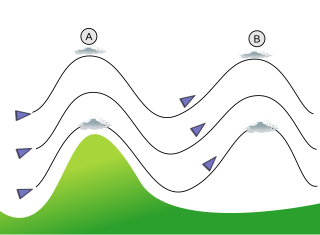
In meteorology, lee waves are atmospheric stationary waves. The most common form is mountain waves, which are atmospheric internal gravity waves. These were discovered in 1933 by two German glider pilots, Hans Deutschmann and Wolf Hirth, above the Giant Mountains. They are periodic changes of atmospheric pressure, temperature and orthometric height in a current of air caused by vertical displacement, for example orographic lift when the wind blows over a mountain or mountain range. They can also be caused by the surface wind blowing over an escarpment or plateau, or even by upper winds deflected over a thermal updraft or cloud street.

Perlan Project Inc. is a 501(c)(3) not-for-profit aeronautical exploration and atmospheric science research organization that utilizes sailplanes (gliders) designed to fly at extremely high altitudes.
A wave cloud is a cloud form created by atmospheric internal waves.
Identifying unidentified flying objects (UFOs) is a difficult task due to the normally poor quality of the evidence provided by those who report sighting the unknown object. Observations and subsequent reporting are often made by those untrained in astronomy, atmospheric phenomena, aeronautics, physics, and perception. Nevertheless, most officially investigated UFO sightings, such as from the U.S. Air Force's Project Blue Book, have been identified as being due to honest misidentifications of natural phenomena, aircraft, or other prosaic explanations. In early U.S. Air Force attempts to explain UFO sightings, unexplained sightings routinely numbered over one in five reports. However, in early 1953, right after the CIA's Robertson Panel, percentages of unexplained sightings dropped precipitously, usually being only a few percent in any given year. When Project Blue Book closed down in 1970, only 6% of all cases were classified as being truly unidentified.

A flying saucer is a descriptive term for a type of flying craft having a disc or saucer-shaped body, commonly used generically to refer to an anomalous flying object. The term was coined in 1947 but has generally been supplanted since 1952 by the United States Air Force term unidentified flying objects. Early reported sightings of unknown "flying saucers" usually described them as silver or metallic, sometimes reported as covered with navigation lights or surrounded with a glowing light, hovering or moving rapidly, either alone or in tight formations with other similar craft, and exhibiting high maneuverability.

The Sierra Wave is a type of air current created by winds that lift off the Sierra Nevada mountain range of California. Known as lee waves, Sierra Waves form as winds hit the Sierra Nevada and are forced to rise, causing water vapor to condense as it cools and forming lenticular clouds on the leeward side of the mountain range. These clouds can remain stationary for many hours. The formation of a Sierra Wave is dependent upon many factors, including wind speed and direction, leeward wind patterns, and water vapor. Given that Sierra Waves are dependent upon many variables their formation is unpredictable. First discovered and studied around 1950, they are used by glider pilots to gain altitude and extend their flights.
Lift is a meteorological phenomenon used as an energy source by soaring aircraft and soaring birds. The most common human application of lift is in sport and recreation. The three air sports that use soaring flight are: gliding, hang gliding and paragliding.

Gliding is a recreational activity and competitive air sport in which pilots fly unpowered aircraft known as gliders or sailplanes using naturally occurring currents of rising air in the atmosphere to remain airborne. The word soaring is also used for the sport.

A glider or sailplane is a type of glider aircraft used in the leisure activity and sport of gliding. This unpowered aircraft can use naturally occurring currents of rising air in the atmosphere to gain altitude. Sailplanes are aerodynamically streamlined and so can fly a significant distance forward for a small decrease in altitude.

The Kenneth Arnold UFO sighting occurred on June 24, 1947, when private pilot Kenneth Arnold claimed that he saw a string of nine, shiny unidentified flying objects flying past Mount Rainier at speeds that Arnold estimated at a minimum of 1,200 miles an hour (1,932 km/h). This was the first post-World War II sighting in the United States that garnered nationwide news coverage and is credited with being the first of the modern era of UFO sightings, including numerous reported sightings over the next two to three weeks. Arnold's description of the objects also led to the press quickly coining the terms flying saucer and flying disc as popular descriptive terms for UFOs.

Cirrocumulus lenticularis is a type of cirrocumulus cloud. The name cirrocumulus lenticularis is derived from Latin, meaning "like a lentil". Cirrocumulus lenticularis are smooth clouds that have the appearance of a lens or an almond. They usually form at the crests of atmospheric waves, which would otherwise be invisible. This species of cirrocumulus can often be quite elongated and normally has very distinguished boundaries. Cirrocumulus lenticularis forms when stable air is forced upward; this is usually due to orographic features, but can occur away from mountains as well. Irisation can occasionally occur with these clouds.

A castellanus is a cloud that displays at least in its upper part cumuliform protuberances having the shape of turrets that give a crenellated aspect. Some of these turrets are higher than they are wide; they have a common base and seem to be arranged in a line. The castellanus characteristic is particularly obvious when the clouds are observed from the side.

Stratocumulus lenticularis is an uncommon cloud type that belongs to the stratocumulus cloud type, its appearance is that of a flat lens or almond. It forms as a result of atmospheric waves caused by wind passing over obstacles; for example, a mountain or a building. They are more common in locations that are hilly, or places where foehn winds are common They tend to look more well-defined when a foehn wind is causing their formation. They also sometimes show iridescence. It is a type of lenticular cloud.

