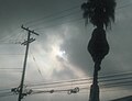
Translucidus (cloud variety)

Last updated

Translucidus is a cloud variety, it appears in altocumulus, altostratus, stratus, and stratocumulus clouds, this cloud variety is very recognizable, with its only feature being that it is translucent, and gives away the location of the Sun and Moon, and sometimes, it lets stars in the night sky be visible, [1] it is the opposite of the cloud variety opacus, which isn't translucent, but opaque. [2] [3] [4]

Contents

This cloud variety manifests in clouds with thin water particles or ice crystals

Translucidus
Altostratus translucidus (18122021).jpg
Altostratus translucidus
Abbreviationtr
Genus Altostratus, altocumulus, stratocumulus, stratus
Variety translucidus
Altitude0-7,000 m
(0-23,000 ft)
Appearancetransparent cloud that gives away the location of the Sun and Moon
Precipitation Depends on the cloud type this variety is appearing in

Examples

See also

Related Research Articles

<span class="mw-page-title-main">Cloud</span> Visible mass of liquid droplets or frozen crystals suspended in the atmosphere

In meteorology, a cloud is an aerosol consisting of a visible mass of miniature liquid droplets, frozen crystals, or other particles suspended in the atmosphere of a planetary body or similar space. Water or various other chemicals may compose the droplets and crystals. On Earth, clouds are formed as a result of saturation of the air when it is cooled to its dew point, or when it gains sufficient moisture from an adjacent source to raise the dew point to the ambient temperature.

<span class="mw-page-title-main">Cumulus cloud</span> Genus of clouds, low-level cloud

Cumulus clouds are clouds that have flat bases and are often described as puffy, cotton-like, or fluffy in appearance. Their name derives from the Latin cumulus, meaning "heap" or "pile". Cumulus clouds are low-level clouds, generally less than 2,000 m (6,600 ft) in altitude unless they are the more vertical cumulus congestus form. Cumulus clouds may appear by themselves, in lines, or in clusters.

<span class="mw-page-title-main">Altocumulus cloud</span> Genus of mid-level cloud

Altocumulus is a middle-altitude cloud genus that belongs mainly to the stratocumuliform physical category characterized by globular masses or rolls in layers or patches, the individual elements being larger and darker than those of cirrocumulus and smaller than those of stratocumulus. However, if the layers become tufted in appearance due to increased airmass instability, then the altocumulus clouds become more purely cumuliform in structure. Like other cumuliform and stratocumuliform clouds, altocumulus signifies convection. A sheet of partially conjoined altocumulus perlucidus is sometimes found preceding a weakening warm front, where the altostratus is starting to fragment, resulting in patches of altocumulus perlucidus between the areas of altostratus. Altocumulus is also commonly found between the warm and cold fronts in a depression, although this is often hidden by lower clouds.

<span class="mw-page-title-main">Altostratus cloud</span> A type of middle-altitude cloud

Altostratus is a middle-altitude cloud genus made up of water droplets, ice crystals, or a mixture of the two. Altostratus clouds are formed when large masses of warm, moist air rise, causing water vapor to condense. Altostratus clouds are usually gray or blueish featureless sheets, although some variants have wavy or banded bases. The sun can be seen through thinner altostratus clouds, but thicker layers can be quite opaque.

<span class="mw-page-title-main">Stratocumulus cloud</span> Family class 3 cloud type

A stratocumulus cloud, occasionally called a cumulostratus, belongs to a genus-type of clouds characterized by large dark, rounded masses, usually in groups, lines, or waves, the individual elements being larger than those in altocumulus, and the whole being at a lower height, usually below 2,000 metres (6,600 ft). Weak convective currents create shallow cloud layers because of drier, stable air above preventing continued vertical development. Historically, in English, this type of cloud has been referred to as a twain cloud for being a combination of two types of clouds.

<span class="mw-page-title-main">Nimbostratus cloud</span> Common type of rain cloud

A nimbostratus cloud is a multilevel, amorphous, nearly uniform, and often dark-grey cloud that usually produces continuous rain, snow, or sleet, but no lightning or thunder.

<span class="mw-page-title-main">Cirrostratus cloud</span> High-altitude, very thin, generally uniform cloud

Cirrostratus is a high-altitude, very thin, generally uniform stratiform genus-type of cloud. It is made out of ice-crystals, which are pieces of frozen water. It is difficult to detect and it can make halos. These are made when the cloud takes the form of thin cirrostratus nebulosus. The cloud has a fibrous texture with no halos if it is thicker cirrostratus fibratus. On the approach of a frontal system, the cirrostratus often begins as nebulous and turns to fibratus. If the cirrostratus begins as fragmented of clouds in the sky it often means the front is weak. Cirrostratus is usually located above 5.5 km (18,000 ft). Its presence indicates a large amount of moisture in the upper troposphere. Clouds resembling cirrostratus occasionally form in polar regions of the lower stratosphere. Polar stratospheric clouds can take on this appearance when composed of tiny supercooled droplets of water or nitric acid.

<span class="mw-page-title-main">Stratus cloud</span> Type of cloud

Stratus clouds are low-level clouds characterized by horizontal layering with a uniform base, as opposed to convective or cumuliform clouds formed by rising thermals. The term stratus describe a flat, hazy, featureless clouds at low altitudes varying in color from dark gray to nearly white. The word stratus comes from the Latin prefix strato-, meaning "layer". Stratus clouds may produce a light drizzle or a small amount of snow. These clouds are essentially above-ground fog formed either through the lifting of morning fog or through cold air moving at low altitudes. Some call these clouds "high fog" for their fog-like form.

Stratus may refer to:

<span class="mw-page-title-main">Warm front</span> Boundary of advancing mass of warm air

A warm front is a density discontinuity located at the leading edge of a homogeneous warm air mass, and is typically located on the equator-facing edge of an isotherm gradient. Warm fronts lie within broader troughs of low pressure than cold fronts, and move more slowly than the cold fronts which usually follow because cold air is denser and less easy to remove from the Earth's surface. This also forces temperature differences across warm fronts to be broader in scale. Clouds ahead of the warm front are mostly stratiform, and rainfall defiantly increases as the front approaches. Fog can also occur preceding a warm frontal passage. Clearing and warming is usually rapid after frontal passage. If the warm air mass is unstable, thunderstorms may be embedded among the stratiform clouds ahead of the front, and after frontal passage thundershowers may continue. On weather maps, the surface location of a warm front is marked with a red line of semicircles pointing in the direction of travel.

<span class="mw-page-title-main">Cumulus mediocris cloud</span>

Cumulus mediocris is a low to middle level cloud with some vertical extent of the genus cumulus, larger in vertical development than Cumulus humilis. It also may exhibit small protuberances from the top and may show the cauliflower form characteristic of cumulus clouds. Cumulus mediocris clouds do not generally produce precipitation of more than very light intensity, but can further advance into clouds such as Cumulus congestus or Cumulonimbus, which do produce precipitation and severe storms.

<span class="mw-page-title-main">Cumulus congestus cloud</span> Form of cumulus clouds

Cumulus congestus clouds, also known as towering cumulus, are a form of cumulus that can be based in the low or middle height ranges. They achieve considerable vertical development in areas of deep, moist convection. They are an intermediate stage between cumulus mediocris and cumulonimbus, sometimes producing showers of snow, rain, or ice pellets. Precipitation that evaporates before reaching the surface is virga.

<span class="mw-page-title-main">Altocumulus undulatus cloud</span>

The altocumulus undulatus is a mid-level cloud, usually white or grey with layers or patches containing undulations that resemble "waves" or "ripples" in water. Elements within the cloud are generally darker than those in cirrocumulus and smaller than those in stratocumulus. These clouds may appear both as patches or as covering the sky. The width of these clouds is generally less than 300 feet thick. The presence of altocumulus undulatus may indicate precipitation within the next 20 hours or simply an overcast day.

<span class="mw-page-title-main">Cirrocumulus lacunosus</span> Cloud type

Cirrocumulus lacunosus also known as Cirrocumulus lacunar or Cirrocumulus lacunaris is a type of cirrocumulus cloud. The term lacunosus is from Latin, meaning "full of hollows". Cirrocumulus lacunosus is a relatively rare cloud form that occurs as a layer of cloud with circular holes in it. Formation is commonly attributed to a cool layer mixing with a warmer, higher layer of the atmosphere. These holes normally have frayed edges, and they are often arranged in a manner that resembles a net or a honeycomb.

A cloud étage is a meteorological term used to delimit any one of three main altitude levels in the troposphere where certain cloud types usually form. The term is derived from the French word which means floor or storey, as in the floor of a multi-storey building. With the exception of the low étage, the altitude range of each level varies according to latitude from Earth's equator to the arctic and antarctic regions at the poles.

<span class="mw-page-title-main">Castellanus</span>

A castellanus is a cloud that displays at least in its upper part cumuliform protuberances having the shape of turrets that give a crenellated aspect. Some of these turrets are higher than they are wide; they have a common base and seem to be arranged in a line. The castellanus characteristic is particularly obvious when the clouds are observed from the side.

<span class="mw-page-title-main">Stratus nebulosus</span>

Stratus nebulosus is a species of low-level stratus cloud. It is one of only two species that is associated with stratus clouds, other being fractus. Translated from Latin meaning nebulous, their cloud abbreviations can be respectively written as ‘St neb’. For a cloud to be classified as nebulosus, there has to be zero sign of detail in the cloud.

<span class="mw-page-title-main">Opacus (cloud variety)</span> Cloud variety that does not let light through

Opacus is a cloud variety commonly found in stratocumulus, altocumulus, altostratus, and stratus cloud types, this cloud variety has an opaque appearance, which hides the location of the Sun and Moon, it is the opposite of translucidus, which is translucent and gives away the location of the Sun and Moon

<span class="mw-page-title-main">Perlucidus (cloud variety)</span>

Perlucidus is a cloud variety that generally appears in only two cloud types, with those cloud types being altocumulus and stratocumulus, this cloud variety is easily recognizable, with its appearance being small gaps showing up in one of the cloud types that it shows up in, which let higher clouds be seen This cloud variety forms when shallow convection starts in a cloud layer that did not previously have perlucidus variety characteristics, the gaps that make the sky visible in these clouds indicate regions where air is sinking, this cloud variety may appear either as a translucent cloud or an opaque cloud

References

  1. "Translucidus".
  2. "Translucidus".
  3. "Translucidus".
  4. "Translucidus - Glossary of Meteorology". Glossary.ametsoc.org. 2012-04-25. Retrieved 2022-08-12.