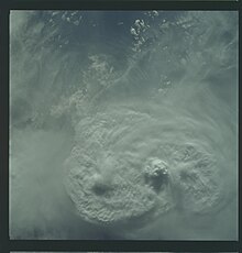
Overshooting top

Last updated
An overshooting top protruding above the anvil at the top of a thunderstorm Cumulonimbus13 - NOAA.jpg
An overshooting top protruding above the anvil at the top of a thunderstorm

An overshooting top (or penetrating top) is a dome-like protrusion shooting out of the top of the anvil of a thunderstorm and into the lower stratosphere. [1] [2] When an overshooting top is present for 10 minutes or longer, it is a strong indication that the storm is severe. [3]

Contents

Formation

Overshooting top of a cumulonimbus viewed from a plane crossing the Democratic Republic of Congo. Airliners typically fly at an altitude ranging from 10 km to 13 km, at the tropopause. Top of cumulo nimbus viwed from an airplane above DRC.jpg
Overshooting top of a cumulonimbus viewed from a plane crossing the Democratic Republic of Congo. Airliners typically fly at an altitude ranging from 10 km to 13 km, at the tropopause.

When a thunderstorm forms, clouds build vertically into the atmosphere until the storm's updraft (warm rising air) has reached an equilibrium level (EL); the point where the surrounding air is about the same temperature or even warmer. [4] This point of equilibrium is often marked by the tropopause. Rather than continuing to rise into the stratosphere, the vertical cloud growth abruptly stops, and instead clouds spread horizontally, forming an "anvil" shape on top of the thunderstorm. [3]

An overshooting top forms when a thunderstorm's updraft, due to momentum from rapid ascent and strength of lifting through the free convective layer (FCL), protrudes its equilibrium level, forming a dome-like structure above the anvil. [5] This can occur with any cumulonimbus cloud when instability is high. Whereas anvils form at the equilibrium level, overshooting tops continue to the maximum parcel level (MPL).

Above-anvil cirrus plume

Cirrus plumes in the wake of overshooting tops may be indicators of severe weather AS09-22-3375 (21413692423).jpg
Cirrus plumes in the wake of overshooting tops may be indicators of severe weather

The strong updrafts delineated by overshooting tops can act as a barrier against the surrounding flow of air. Fast stratospheric winds may rise slightly upon encountering overshooting tops, cooling and producing a turbulent wake of cooler temperatures downstream of the updraft. This interaction also sheds ice and water vapor from the anvil cloud, forming a plume of cirrus emanating from the updraft region, [6] [7] though this is most evident in mid-latitude environments where the tropopause is typically lower and the associated inversion wider. [8] These cirrus plumes may be warmer than the underlying anvil cloud due to the mixing of air from the warmer stratosphere. Termed above-anvil cirrus plumes (AACP), the emergence of such features on satellite imagery have been associated with severe weather events. [6] [7] A 2018 study published in Weather and Forecasting found that 73 percent of significant severe weather reports in the United States were associated with storms producing AACPs and that AACPs emerged an average of 31 minutes before the issuance of severe weather warnings. [9] Simulations suggest that overshooting tops behave like hydraulic jumps in the presence of strong winds aloft, allowing the transport of over 7 t (7.7 tons) of water vapor into the lower stratosphere per second. [10]

Severe weather

Diagram of a supercell thunderstorm, which shows the overshooting top rising above the anvil cloud. Tornadic supercell.jpg
Diagram of a supercell thunderstorm, which shows the overshooting top rising above the anvil cloud.

Many thunderstorms exhibit an overshooting top at some point in their life cycle. [4] In weaker thunderstorms, the overshooting top is short-lived, and often takes on a wispy appearance. [5] If the overshooting top is rising and falling in a cyclical fashion with each protrusion persisting only a few minutes, then it could indicate the storm is pulsing and not as strong as a storm with a continuous overshooting top. [11]

An overshooting top lasting for more than 10 minutes is a sign of a strong updraft in a thunderstorm, indicating a strong likelihood the storm is producing severe weather. [4] If the overshooting top is continuous, it's an indication of enhanced probability that the storm is a supercell, i.e. a rotating storm. [5] During a strong tornado, the overshooting top may roll or fold over as new activity climbs up the back while the front of the overshooting top collapses into the storm. During a long-track tornado, the entire top of the storm, including the overshooting top, may drop by thousands of feet.[ citation needed ]

Storm features

A storm powerful enough to produce a lasting overshooting top typically produces the following[ citation needed ]:

See also

Related Research Articles

<span class="mw-page-title-main">Cloud</span> Visible mass of liquid droplets or frozen crystals suspended in the atmosphere

In meteorology, a cloud is an aerosol consisting of a visible mass of miniature liquid droplets, frozen crystals, or other particles suspended in the atmosphere of a planetary body or similar space. Water or various other chemicals may compose the droplets and crystals. On Earth, clouds are formed as a result of saturation of the air when it is cooled to its dew point, or when it gains sufficient moisture from an adjacent source to raise the dew point to the ambient temperature.

<span class="mw-page-title-main">Cumulonimbus cloud</span> Genus of dense, towering vertical clouds

Cumulonimbus is a dense, towering vertical cloud, typically forming from water vapor condensing in the lower troposphere that builds upward carried by powerful buoyant air currents. Above the lower portions of the cumulonimbus the water vapor becomes ice crystals, such as snow and graupel, the interaction of which can lead to hail and to lightning formation, respectively. When occurring as a thunderstorm these clouds may be referred to as thunderheads. Cumulonimbus can form alone, in clusters, or along squall lines. These clouds are capable of producing lightning and other dangerous severe weather, such as tornadoes, hazardous winds, and large hailstones. Cumulonimbus progress from overdeveloped cumulus congestus clouds and may further develop as part of a supercell. Cumulonimbus is abbreviated Cb.

<span class="mw-page-title-main">Thunderstorm</span> Storm characterized by lightning and thunder

A thunderstorm, also known as an electrical storm or a lightning storm, is a storm characterized by the presence of lightning and its acoustic effect on the Earth's atmosphere, known as thunder. Relatively weak thunderstorms are sometimes called thundershowers. Thunderstorms occur in a type of cloud known as a cumulonimbus. They are usually accompanied by strong winds and often produce heavy rain and sometimes snow, sleet, or hail, but some thunderstorms produce little precipitation or no precipitation at all. Thunderstorms may line up in a series or become a rainband, known as a squall line. Strong or severe thunderstorms include some of the most dangerous weather phenomena, including large hail, strong winds, and tornadoes. Some of the most persistent severe thunderstorms, known as supercells, rotate as do cyclones. While most thunderstorms move with the mean wind flow through the layer of the troposphere that they occupy, vertical wind shear sometimes causes a deviation in their course at a right angle to the wind shear direction.

<span class="mw-page-title-main">Supercell</span> Thunderstorm that is characterized by the presence of a mesocyclone

A supercell is a thunderstorm characterized by the presence of a mesocyclone, a deep, persistently rotating updraft. Due to this, these storms are sometimes referred to as rotating thunderstorms. Of the four classifications of thunderstorms, supercells are the overall least common and have the potential to be the most severe. Supercells are often isolated from other thunderstorms, and can dominate the local weather up to 32 kilometres (20 mi) away. They tend to last 2–4 hours.

<span class="mw-page-title-main">Squall</span> Short, sharp increase in wind speed

A squall is a sudden, sharp increase in wind speed lasting minutes, as opposed to a wind gust, which lasts for only seconds. They are usually associated with active weather, such as rain showers, thunderstorms, or heavy snow. Squalls refer to the increase of the sustained winds over that time interval, as there may be higher gusts during a squall event. They usually occur in a region of strong sinking air or cooling in the mid-atmosphere. These force strong localized upward motions at the leading edge of the region of cooling, which then enhances local downward motions just in its wake.

<span class="mw-page-title-main">Mammatus cloud</span> Distinct pattern of pouches on the underside of some clouds

Mammatus is a cellular pattern of pouches hanging underneath the base of a cloud, typically a cumulonimbus raincloud, although they may be attached to other classes of parent clouds. The name mammatus is derived from the Latin mamma.

<span class="mw-page-title-main">Squall line</span> Line of thunderstorms along or ahead of a cold front

A squall line, or more accurately a quasi-linear convective system (QLCS), is a line of thunderstorms, often forming along or ahead of a cold front. In the early 20th century, the term was used as a synonym for cold front. Linear thunderstorm structures often contain heavy precipitation, hail, frequent lightning, strong straight-line winds, and occasionally tornadoes or waterspouts. Particularly strong straight-line winds can occur where the linear structure forms into the shape of a bow echo. Tornadoes can occur along waves within a line echo wave pattern (LEWP), where mesoscale low-pressure areas are present. Some bow echoes can grow to become derechos as they move swiftly across a large area. On the back edge of the rainband associated with mature squall lines, a wake low can be present, on very rare occasions associated with a heat burst.

<span class="mw-page-title-main">Wall cloud</span> Cloud formation occurring at the base of a thunderstorm

A wall cloud is a large, localized, persistent, and often abrupt lowering of cloud that develops beneath the surrounding base of a cumulonimbus cloud and from which tornadoes sometimes form. It is typically beneath the rain-free base (RFB) portion of a thunderstorm, and indicates the area of the strongest updraft within a storm. Rotating wall clouds are an indication of a mesocyclone in a thunderstorm; most strong tornadoes form from these. Many wall clouds do rotate; however, some do not.

<span class="mw-page-title-main">Convective available potential energy</span> Measure of instability in the air as a buoyancy force

In meteorology, convective available potential energy, is the integrated amount of work that the upward (positive) buoyancy force would perform on a given mass of air if it rose vertically through the entire atmosphere. Positive CAPE will cause the air parcel to rise, while negative CAPE will cause the air parcel to sink. Nonzero CAPE is an indicator of atmospheric instability in any given atmospheric sounding, a necessary condition for the development of cumulus and cumulonimbus clouds with attendant severe weather hazards.

<span class="mw-page-title-main">Cumulonimbus calvus</span> Large cloud

Cumulonimbus calvus is a moderately tall cumulonimbus cloud that is capable of precipitation but has not yet reached the tropopause, which is the height of stratospheric stability at which cumulonimbus forms into cumulonimbus capillatus (fibrous-top) or cumulonimbus incus (anvil-top). Cumulonimbus calvus develops from cumulus congestus, and its further development, under auspicious conditions, will result in cumulonimbus incus.

<span class="mw-page-title-main">Cumulonimbus incus</span> Cumulonimbus with an incus (anvil) cloud as a supplementary feature

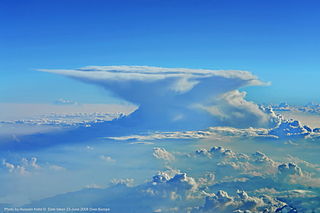
A cumulonimbus incus, also called an anvil cloud, is a cumulonimbus cloud that has reached the level of stratospheric stability and has formed the characteristic flat, anvil-shaped top. It signifies a thunderstorm in its mature stage, succeeding the cumulonimbus calvus stage. Cumulonimbus incus is a subtype of cumulonimbus capillatus. These clouds are commonly associated with severe weather, including heavy rain, downbursts, and occasionally a tornado.

<span class="mw-page-title-main">Equilibrium level</span>

In meteorology, the equilibrium level (EL), or level of neutral buoyancy (LNB), or limit of convection (LOC), is the height at which a rising parcel of air is at the same temperature as its environment.

<span class="mw-page-title-main">Air-mass thunderstorm</span> Thunderstorm that is generally weak and usually not severe

An air-mass thunderstorm, also called an "ordinary", "single cell", "isolated" or "garden variety" thunderstorm, is a thunderstorm that is generally weak and usually not severe. These storms form in environments where at least some amount of Convective Available Potential Energy (CAPE) is present, but with very low levels of wind shear and helicity. The lifting source, which is a crucial factor in thunderstorm development, is usually the result of uneven heating of the surface, though they can be induced by weather fronts and other low-level boundaries associated with wind convergence. The energy needed for these storms to form comes in the form of insolation, or solar radiation. Air-mass thunderstorms do not move quickly, last no longer than an hour, and have the threats of lightning, as well as showery light, moderate, or heavy rainfall. Heavy rainfall can interfere with microwave transmissions within the atmosphere.

<span class="mw-page-title-main">Atmospheric convection</span> Atmospheric phenomenon

Atmospheric convection is the result of a parcel-environment instability in the atmosphere. Different lapse rates within dry and moist air masses lead to instability. Mixing of air during the day expands the height of the planetary boundary layer, leading to increased winds, cumulus cloud development, and decreased surface dew points. Convection involving moist air masses leads to thunderstorm development, which is often responsible for severe weather throughout the world. Special threats from thunderstorms include hail, downbursts, and tornadoes.

Convective storm detection is the meteorological observation, and short-term prediction, of deep moist convection (DMC). DMC describes atmospheric conditions producing single or clusters of large vertical extension clouds ranging from cumulus congestus to cumulonimbus, the latter producing thunderstorms associated with lightning and thunder. Those two types of clouds can produce severe weather at the surface and aloft.

The maximum parcel level (MPL) is the highest level in the atmosphere that a moist convectively rising air parcel will reach after ascending from the level of free convection (LFC) through the free convective layer (FCL) and reaching the equilibrium level (EL), near the tropopause. As the parcel rises through the FCL it expands adiabatically causing its temperature to drop, often below the temperature of its surroundings, and eventually lose buoyancy. Because of this, the EL is approximately the region where the distinct flat tops, often observed around the upper portions of cumulonimbus clouds. If the air parcel ascended quickly enough then it retains momentum after it has cooled and continues rising past the EL, ceasing at the MPL.

The following is a glossary of tornado terms. It includes scientific as well as selected informal terminology.

Numerous accidents have occurred in the vicinity of thunderstorms due to the density of clouds. It is often said that the turbulence can be extreme enough inside a cumulonimbus to tear an aircraft into pieces, and even strong enough to hold a skydiver. However, this kind of accident is relatively rare. Moreover, the turbulence under a thunderstorm can be non-existent and is usually no more than moderate. Most thunderstorm-related crashes occur due to a stall close to the ground when the pilot gets caught by surprise by a thunderstorm-induced wind shift. Moreover, aircraft damage caused by thunderstorms is rarely in the form of structural failure due to turbulence but is typically less severe and the consequence of secondary effects of thunderstorms.

<span class="mw-page-title-main">Glossary of meteorology</span> List of definitions of terms and concepts commonly used in meteorology

This glossary of meteorology is a list of terms and concepts relevant to meteorology and atmospheric science, their sub-disciplines, and related fields.

References

  1. Shenk, W. E. (1974). "Cloud top height variability of strong convective cells". Journal of Applied Meteorology . 13 (8): 918–922. Bibcode:1974JApMe..13..917S. doi: 10.1175/1520-0450(1974)013<0917:cthvos>2.0.co;2 .
  2. "Overshooting Tops – Satellite-Based Detection Methods". EUMETSAT. 9 June 2011. Archived from the original on 10 May 2019. Retrieved 10 May 2019.
  3. 1 2 Chance Hayes, National Weather Service Wichita, Kansas. "Storm Fury on the Plains." Storm Spotter Training. 4H Building, Salina, Kansas. 22 Feb. 2010. Lecture.
  4. 1 2 3 "Thunderstorm Detection". National Severe Storms Lab (NSSL). Archived from the original on 2009-03-27. Retrieved 2009-02-28.
  5. 1 2 3 "Overshooting Top definition". NSSL. Archived from the original on 2011-09-27. Retrieved 2009-02-28.
  6. 1 2 "Severe Storms Show off their "Plume-age"". NASA. August 15, 2018. Retrieved September 14, 2023.
  7. 1 2 Phillips, Jean (September 9, 2021). "Scientists gain better understanding of icy plumes associated with violent tornadoes". Madison, Wisconsin: University of WisconsinMadison. Retrieved September 14, 2023.
  8. Murillo, Elisa M.; Homeyer, Cameron R. (December 2022). "What Determines Above-Anvil Cirrus Plume Infrared Temperature?". Journal of the Atmospheric Sciences. 79 (12): 3181–3194. Bibcode:2022JAtS...79.3181M. doi: 10.1175/JAS-D-22-0080.1 .
  9. Bedka, Kristopher; Murillo, Elisa M.; Homeyer, Cameron R.; Scarino, Benjamin; Mersiovsky, Haiden (October 2018). "The Above-Anvil Cirrus Plume: An Important Severe Weather Indicator in Visible and Infrared Satellite Imagery". Weather and Forecasting. 33 (5): 1159–1181. Bibcode:2018WtFor..33.1159B. doi: 10.1175/WAF-D-18-0040.1 .
  10. O’Neill, Morgan E; Orf, Leigh; Heymsfield, Gerald M.; Halbert, Kelton (September 10, 2021). "Hydraulic jump dynamics above supercell thunderstorms". Science. 373 (6560): 1248–1251. Bibcode:2021Sci...373.1248O. doi:10.1126/science.abh3857. PMID   34516791. S2CID   237473018.
  11. "JetStream - Glossary". National Weather Service. August 29, 2007. Retrieved 2008-02-28.