| Altocumulus stratiformis | |
|---|---|
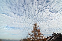 Altocumulus stratiformis over Germany in 2011 | |
| Abbreviation | Ac str |
| Genus | Altocumulus (high, heaped) |
| Species | stratiformis |
| Variety |
|
| Altitude | 2,000 - 6,000 m (6,500 - 20,000 ft) |
| Classification | Family B (Medium-level) |
| Appearance | Patchy and shallow; often semi-transparent. |
| Precipitation | Uncommon |
Altocumulus stratiformis is the most common species of the Altocumulus genus of clouds. [1] They tend to form broad layers of individual, cell-like clumps, often separated from each other, though they sometimes can coagulate into a larger individual cloud. They often have a vertical extent of less than 500 m. [2] Due to their formation dynamics, they are commonly associated with the imminent arrival of precipitation.