
In meteorology, a cloud is an aerosol consisting of a visible mass of miniature liquid droplets, frozen crystals, or other particles suspended in the atmosphere of a planetary body or similar space. Water or various other chemicals may compose the droplets and crystals. On Earth, clouds are formed as a result of saturation of the air when it is cooled to its dew point, or when it gains sufficient moisture from an adjacent source to raise the dew point to the ambient temperature.

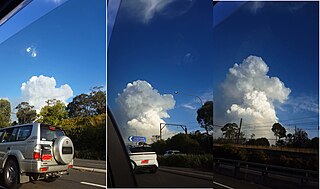
Cumulonimbus is a dense, towering, vertical cloud, typically forming from water vapor condensing in the lower troposphere that builds upward carried by powerful buoyant air currents. Above the lower portions of the cumulonimbus the water vapor becomes ice crystals, such as snow and graupel, the interaction of which can lead to hail and to lightning formation, respectively.

Cumulus clouds are clouds that have flat bases and are often described as puffy, cotton-like, or fluffy in appearance. Their name derives from the Latin cumulus, meaning "heap" or "pile". Cumulus clouds are low-level clouds, generally less than 2,000 m (6,600 ft) in altitude unless they are the more vertical cumulus congestus form. Cumulus clouds may appear by themselves, in lines, or in clusters.

Altocumulus is a middle-altitude cloud genus that belongs mainly to the stratocumuliform physical category, characterized by globular masses or rolls in layers or patches – the individual elements being larger and darker than those of cirrocumulus and smaller than those of stratocumulus. However, if the layers become tufted in appearance due to increased airmass instability, then the altocumulus clouds become more purely cumuliform in structure. Like other cumuliform and stratocumuliform clouds, altocumulus signifies convection. A sheet of partially conjoined altocumulus perlucidus is sometimes found preceding a weakening warm front, where the altostratus is starting to fragment, resulting in patches of altocumulus perlucidus between the areas of altostratus. Altocumulus is also commonly found between the warm and cold fronts in a depression, although this is often hidden by lower clouds.

A nimbostratus cloud is a multilevel, amorphous, nearly uniform, and often dark-grey cloud that usually produces continuous rain, snow, or sleet, but no lightning or thunder.
Stratus clouds are low-level clouds characterized by horizontal layering with a uniform base, as opposed to convective or cumuliform clouds formed by rising thermals. The term stratus describes flat, hazy, featureless clouds at low altitudes varying in color from dark gray to nearly white. The word stratus comes from the Latin prefix strato-, meaning "layer". Stratus clouds may produce a light drizzle or a small amount of snow. These clouds are essentially above-ground fog formed either through the lifting of morning fog or through cold air moving at low altitudes. Some call these clouds "high fog" for their fog-like form.

A flammagenitus cloud, also known as a flammagenitus, pyrocumulus cloud, or fire cloud, is a dense cumuliform cloud associated with fire or volcanic eruptions. A flammagenitus is similar dynamically in some ways to a firestorm, and the two phenomena may occur in conjunction with each other. However, either may occur without the other.

An accessory cloud is a cloud which is dependent on a larger cloud system for its development and continuance. It is often an appendage but also can be adjacent to the parent cloud system.

Cumulus mediocris is a low to middle level cloud with some vertical extent of the genus cumulus, larger in vertical development than Cumulus humilis. It also may exhibit small protuberances from the top and may show the cauliflower form characteristic of cumulus clouds. Cumulus mediocris clouds do not generally produce precipitation of more than very light intensity, but can further advance into clouds such as Cumulus congestus or Cumulonimbus, which do produce precipitation and severe storms.

A pileus, also called scarf cloud or cap cloud, is a small, horizontal, lenticular cloud appearing above a cumulus or cumulonimbus cloud. Pileus clouds are often short-lived, appearing for typically only a few minutes, with the main cloud beneath them rising through convection to absorb them. Furthermore, the clouds are typically formed by drier air with a higher lifting condensation level, which often prevents vertical growth and leads to the smooth horizontal cap shape that the cloud is named for.

Cumulus congestus or towering cumulus clouds are a species of cumulus that can be based in the low- to middle-height ranges. They achieve considerable vertical development in areas of deep, moist convection. They are an intermediate stage between cumulus mediocris and cumulonimbus, sometimes producing rainshowers, snow, or ice pellets. Precipitation that evaporates before reaching the surface is virga.
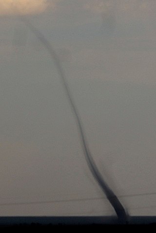
Landspout is a term created by atmospheric scientist Howard B. Bluestein in 1985 for a tornado not associated with a mesocyclone. The Glossary of Meteorology defines a landspout:

Fractus clouds, also called fractostratus or fractocumulus, are small, ragged cloud fragments that are usually found under an ambient cloud base. They form or have broken off from a larger cloud, and are generally sheared by strong winds, giving them a jagged, shredded appearance. Fractus have irregular patterns, appearing much like torn pieces of cotton candy. They change constantly, often forming and dissipating rapidly. They do not have clearly defined bases. Sometimes they are persistent and form very near the surface. Common kinds include scud and cloud tags.

An arcus cloud is a low, horizontal cloud formation, usually appearing as an accessory cloud to a cumulonimbus. Roll clouds and shelf clouds are the two main types of arcus clouds. They most frequently form along the leading edge or gust fronts of thunderstorms; some of the most dramatic arcus formations mark the gust fronts of derecho-producing convective systems. Roll clouds may also arise in the absence of thunderstorms, forming along the shallow cold air currents of some sea breeze boundaries and cold fronts.
The cumulonimbus flammagenitus cloud (CbFg), also known as the pyrocumulonimbus cloud, is a type of cumulonimbus cloud that forms above a source of heat, such as a wildfire, nuclear explosion, or volcanic eruption, and may sometimes even extinguish the fire that formed it. It is the most extreme manifestation of a flammagenitus cloud. According to the American Meteorological Society’s Glossary of Meteorology, a flammagenitus is "a cumulus cloud formed by a rising thermal from a fire, or enhanced by buoyant plume emissions from an industrial combustion process."

Pannus, or scud clouds, is a type of fractus cloud at low height above ground, detached, and of irregular form, found beneath nimbostratus, cumulonimbus, altostratus and cumulus clouds. These clouds are often ragged or wispy in appearance. When caught in the outflow (downdraft) beneath a thunderstorm, scud clouds will often move faster than the storm clouds themselves. If the parent cloud that scud clouds pair with were to suddenly dissipate, the pannus cloud accessory would not be able to be told apart from a fractus cloud formation.

A flanking line is an area of cumulus congestus or small cumulonimbus that mark an area of widespread updrafts on the edge of strong thunderstorms. These flanking lines generally occur in the vicinity of supercell thunderstorms or large multicell thunderstorms.
Numerous accidents have occurred in the vicinity of thunderstorms due to the density of clouds. It is often said that the turbulence can be extreme enough inside a cumulonimbus to tear an aircraft into pieces, and even strong enough to hold a skydiver. However, this kind of accident is relatively rare. Moreover, the turbulence under a thunderstorm can be non-existent and is usually no more than moderate. Most thunderstorm-related crashes occur due to a stall close to the ground when the pilot gets caught by surprise by a thunderstorm-induced wind shift. Moreover, aircraft damage caused by thunderstorms is rarely in the form of structural failure due to turbulence but is typically less severe and the consequence of secondary effects of thunderstorms.
