| Cirrus uncinus | |
|---|---|
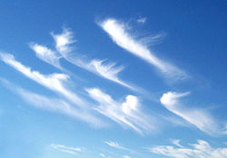 Cirrus uncinus cloud | |
| Abbreviation | Ci unc |
| Genus | Cirrus ("curl") |
| Species | uncinus ("hook") |
| Altitude | above 7,000 m (23,000 ft) |
| Classification | Family A (High-level) |
| Appearance | curly, hooked |
| Precipitation | No, but may indicate precipitation approach. |
Cirrus uncinus is a species of cirrus cloud. The name cirrus uncinus is Latin for "curly hooks". Commonly called "mare's tail", this cloud species is very thin and generally sparse in the sky. [1]
Contents
The clouds occur at high altitudes, at a temperature of about −50 to −40 °C (−58 to −40 °F). They are generally seen when a warm or occluded front is approaching. They are very high in the troposphere and generally mean that precipitation, usually rain, is approaching. [2]
 Cirrus uncinus clouds over Salinas Victoria, Nuevo León, Mexico
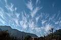 Cirrus uncinus clouds in the morning sky over Nandli, Himachal Pradesh, India

