
A tornado is a violently rotating column of air that is in contact with both the surface of the Earth and a cumulonimbus cloud or, in rare cases, the base of a cumulus cloud. It is often referred to as a twister, whirlwind or cyclone, although the word cyclone is used in meteorology to name a weather system with a low-pressure area in the center around which, from an observer looking down toward the surface of the Earth, winds blow counterclockwise in the Northern Hemisphere and clockwise in the Southern. Tornadoes come in many shapes and sizes, and they are often visible in the form of a condensation funnel originating from the base of a cumulonimbus cloud, with a cloud of rotating debris and dust beneath it. Most tornadoes have wind speeds less than 180 kilometers per hour, are about 80 meters across, and travel several kilometers before dissipating. The most extreme tornadoes can attain wind speeds of more than 480 kilometers per hour (300 mph), can be more than 3 kilometers (2 mi) in diameter, and can stay on the ground for more than 100 km (62 mi).

Cumulus clouds are clouds that have flat bases and are often described as puffy, cotton-like, or fluffy in appearance. Their name derives from the Latin cumulus, meaning "heap" or "pile". Cumulus clouds are low-level clouds, generally less than 2,000 m (6,600 ft) in altitude unless they are the more vertical cumulus congestus form. Cumulus clouds may appear by themselves, in lines, or in clusters.

A thunderstorm, also known as an electrical storm or a lightning storm, is a storm characterized by the presence of lightning and its acoustic effect on the Earth's atmosphere, known as thunder. Relatively weak thunderstorms are sometimes called thundershowers. Thunderstorms occur in a type of cloud known as a cumulonimbus. They are usually accompanied by strong winds and often produce heavy rain and sometimes snow, sleet, or hail, but some thunderstorms produce little precipitation or no precipitation at all. Thunderstorms may line up in a series or become a rainband, known as a squall line. Strong or severe thunderstorms include some of the most dangerous weather phenomena, including large hail, strong winds, and tornadoes. Some of the most persistent severe thunderstorms, known as supercells, rotate as do cyclones. While most thunderstorms move with the mean wind flow through the layer of the troposphere that they occupy, vertical wind shear sometimes causes a deviation in their course at a right angle to the wind shear direction.

A mesocyclone is a meso-gamma mesoscale region of rotation (vortex), typically around 2 to 6 mi in diameter, most often noticed on radar within thunderstorms. In the northern hemisphere it is usually located in the right rear flank of a supercell, or often on the eastern, or leading, flank of a high-precipitation variety of supercell. The area overlaid by a mesocyclone’s circulation may be several miles (km) wide, but substantially larger than any tornado that may develop within it, and it is within mesocyclones that intense tornadoes form.

A squall is a sudden, sharp increase in wind speed lasting minutes, as opposed to a wind gust, which lasts for only seconds. They are usually associated with active weather, such as rain showers, thunderstorms, or heavy snow. Squalls refer to the increase of the sustained winds over that time interval, as there may be higher gusts during a squall event. They usually occur in a region of strong sinking air or cooling in the mid-atmosphere. These force strong localized upward motions at the leading edge of the region of cooling, which then enhances local downward motions just in its wake.

A squall line, or quasi-linear convective system (QLCS), is a line of thunderstorms, often forming along or ahead of a cold front. In the early 20th century, the term was used as a synonym for cold front. Linear thunderstorm structures often contain heavy precipitation, hail, frequent lightning, strong straight-line winds, and occasionally tornadoes or waterspouts. Particularly strong straight-line winds can occur where the linear structure forms into the shape of a bow echo. Tornadoes can occur along waves within a line echo wave pattern (LEWP), where mesoscale low-pressure areas are present. Some bow echoes can grow to become derechos as they move swiftly across a large area. On the back edge of the rainband associated with mature squall lines, a wake low can be present, on very rare occasions associated with a heat burst.
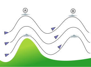
In meteorology, lee waves are atmospheric stationary waves. The most common form is mountain waves, which are atmospheric internal gravity waves. These were discovered in 1933 by two German glider pilots, Hans Deutschmann and Wolf Hirth, above the Giant Mountains. They are periodic changes of atmospheric pressure, temperature and orthometric height in a current of air caused by vertical displacement, for example orographic lift when the wind blows over a mountain or mountain range. They can also be caused by the surface wind blowing over an escarpment or plateau, or even by upper winds deflected over a thermal updraft or cloud street.

A waterspout is a rotating column of air that occurs over a body of water, usually appearing as a funnel-shaped cloud in contact with the water and a cumuliform cloud. There are two types of waterspout, each formed by distinct mechanisms. The most common type is a weak vortex known as a "fair weather" or "non-tornadic" waterspout. The other less common type is simply a classic tornado occurring over water rather than land, known as a "tornadic", "supercellular", or "mesocyclonic" waterspout, and accurately a "tornado over water". A fair weather waterspout has a five-part life cycle: formation of a dark spot on the water surface; spiral pattern on the water surface; formation of a spray ring; development of a visible condensation funnel; and ultimately, decay. Most waterspouts do not suck up water.

Cyclogenesis is the development or strengthening of cyclonic circulation in the atmosphere. Cyclogenesis is an umbrella term for at least three different processes, all of which result in the development of some sort of cyclone, and at any size from the microscale to the synoptic scale.

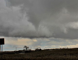
A funnel cloud is a funnel-shaped cloud of condensed water droplets, associated with a rotating column of wind and extending from the base of a cloud but not reaching the ground or a water surface. A funnel cloud is usually visible as a cone-shaped or needle like protuberance from the main cloud base. Funnel clouds form most frequently in association with supercell thunderstorms, and are often, but not always, a visual precursor to tornadoes. Funnel clouds are visual phenomena, but these are not the vortex of wind itself.

A gustnado is a brief, shallow surface-based vortex which forms within the downburst emanating from a thunderstorm. The name is a portmanteau by elision of "gust front tornado", as gustnadoes form due to non-tornadic straight-line wind features in the downdraft (outflow), specifically within the gust front of strong thunderstorms. Gustnadoes tend to be noticed when the vortices loft sufficient debris or form condensation cloud to be visible although it is the wind that makes the gustnado, similarly to tornadoes. As these eddies very rarely connect from the surface to the cloud base, they are very rarely considered as tornadoes. The gustnado has little in common with tornadoes structurally or dynamically in regard to vertical development, intensity, longevity, or formative process—as classic tornadoes are associated with mesocyclones within the inflow (updraft) of the storm, not the outflow.

Landspout is a term created by atmospheric scientist Howard B. Bluestein in 1985 for a tornado not associated with a mesocyclone. The Glossary of Meteorology defines a landspout:

An arcus cloud is a low, horizontal cloud formation, usually appearing as an accessory cloud to a cumulonimbus. Roll clouds and shelf clouds are the two main types of arcus clouds. They most frequently form along the leading edge or gust fronts of thunderstorms; some of the most dramatic arcus formations mark the gust fronts of derecho-producing convective systems. Roll clouds may also arise in the absence of thunderstorms, forming along the shallow cold air currents of some sea breeze boundaries and cold fronts.
Tornadogenesis is the process by which a tornado forms. There are many types of tornadoes, varying in methods of formation. Despite ongoing scientific study and high-profile research projects such as VORTEX, tornadogenesis is a volatile process and the intricacies of many of the mechanisms of tornado formation are still poorly understood.
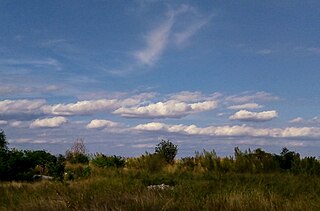
Horizontal convective rolls, also known as horizontal roll vortices or cloud streets, are long rolls of counter-rotating air that are oriented approximately parallel to the ground in the planetary boundary layer. Although horizontal convective rolls, also known as cloud streets, have been clearly seen in satellite photographs for the last 30 years, their development is poorly understood, due to a lack of observational data. From the ground, they appear as rows of cumulus or cumulus-type clouds aligned parallel to the low-level wind. Research has shown these eddies to be significant to the vertical transport of momentum, heat, moisture, and air pollutants within the boundary layer. Cloud streets are usually more or less straight; rarely, cloud streets assume paisley patterns when the wind driving the clouds encounters an obstacle. Those cloud formations are known as von Kármán vortex streets.

Atmospheric convection is the result of a parcel-environment instability in the atmosphere. Different lapse rates within dry and moist air masses lead to instability. Mixing of air during the day expands the height of the planetary boundary layer, leading to increased winds, cumulus cloud development, and decreased surface dew points. Convection involving moist air masses leads to thunderstorm development, which is often responsible for severe weather throughout the world. Special threats from thunderstorms include hail, downbursts, and tornadoes.

Pannus, or scud clouds, is a type of fractus cloud at low height above ground, detached, and of irregular form, found beneath nimbostratus, cumulonimbus, altostratus and cumulus clouds. These clouds are often ragged or wispy in appearance. When caught in the outflow (downdraft) beneath a thunderstorm, scud clouds will often move faster than the storm clouds themselves. If the parent cloud that scud clouds pair with were to suddenly dissipate, the pannus cloud accessory would not be able to be told apart from a fractus cloud formation.
The following is a glossary of tornado terms. It includes scientific as well as selected informal terminology.
Numerous aviation accidents have occurred in the vicinity of thunderstorms due to the density of clouds. It is often said that the turbulence can be extreme enough inside a cumulonimbus to tear an aircraft into pieces, and even strong enough to hold a skydiver. However, this kind of accident is relatively rare. Moreover, the turbulence under a thunderstorm can be non-existent and is usually no more than moderate. Most thunderstorm-related crashes occur due to a stall close to the ground when the pilot gets caught by surprise by a thunderstorm-induced wind shift. Moreover, aircraft damage caused by thunderstorms is rarely in the form of structural failure due to turbulence but is typically less severe and the consequence of secondary effects of thunderstorms.

This glossary of meteorology is a list of terms and concepts relevant to meteorology and atmospheric science, their sub-disciplines, and related fields.
