This article needs additional citations for verification .(March 2022) |
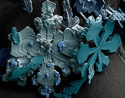
Ice crystals are solid ice in symmetrical shapes including hexagonal columns, hexagonal plates, and dendritic crystals. [1] Ice crystals are responsible for various atmospheric optic displays and cloud formations. [1] [2]
At ambient temperature and pressure, water molecules have a V shape. The two hydrogen atoms bond to the oxygen atom at a 105° angle. [3] Ice crystals have a hexagonal crystal lattice, meaning the water molecules arrange themselves into layered hexagons upon freezing. [1]
Slower crystal growth from colder and drier atmospheres produces more hexagonal symmetry. [2] Depending on environmental temperature and humidity, ice crystals can develop from the initial hexagonal prism into many symmetric shapes. [4] Possible shapes for ice crystals are columns, needles, plates and dendrites. Mixed patterns are also possible. [1] The symmetric shapes are due to depositional growth, which is when ice forms directly from water vapor in the atmosphere. [5] Small spaces in atmospheric particles can also collect water, freeze, and form ice crystals. [6] [7] This is known as nucleation. [8] Snowflakes form when additional vapor freezes onto an existing ice crystal. [9] [10]
Supercooled water refers to water below its freezing point that is still liquid. [11] Ice crystals formed from supercooled water have stacking defects in their layered hexagons. This causes ice crystals to display trigonal or cubic symmetry depending on the temperature. Trigonal or cubic crystals form in the upper atmosphere where supercooling occurs. [12] [13]
Water can pass through laminated sheets of graphene oxide unlike smaller molecules such as helium. When squeezed between two layers of graphene, water forms square ice crystals at room temperature. Researchers believe high pressure and the van der Waals force, an attractive force present between all molecules, drives the formation. The material is a new crystalline phase of ice. [3] [14]
Ice crystals create optical phenomena like diamond dust and halos in the sky due to light reflecting off of the crystals in a process called scattering. [1] [2] [15]
Cirrus clouds and ice fog are made of ice crystals. [1] [16] Cirrus clouds are often the sign of an approaching warm front, where warm and moist air rises and freezes into ice crystals. [17] [18] Ice crystals rubbing against each other also produces lightning. [19] [20] The crystals normally fall horizontally, [21] but electric fields can cause them to clump together and fall in other directions. [22] [23]
The aerospace industry is working to design a radar that can detect ice crystal environments to discern hazardous flight conditions. Ice crystals can melt when they touch the surface of warm aircraft, and refreeze due to environmental conditions. The accumulation of ice around the engine damages the aircraft. [24] [25] Weather forecasting uses differential reflectivity weather radars to identify types of precipitation by comparing a droplet's horizontal and vertical lengths. [26] Ice crystals are larger in the horizontal direction [15] and are thus detectable.
Snow comprises individual ice crystals that grow while suspended in the atmosphere—usually within clouds—and then fall, accumulating on the ground where they undergo further changes. It consists of frozen crystalline water throughout its life cycle, starting when, under suitable conditions, the ice crystals form in the atmosphere, increase to millimeter size, precipitate and accumulate on surfaces, then metamorphose in place, and ultimately melt, slide or sublimate away.
Cirrus is a genus of high cloud made of ice crystals. Cirrus clouds typically appear delicate and wispy with white strands. Cirrus are usually formed when warm, dry air rises, causing water vapor deposition onto rocky or metallic dust particles at high altitudes. Globally, they form anywhere between 4,000 and 20,000 meters above sea level, with the higher elevations usually in the tropics and the lower elevations in more polar regions.
In meteorology, a cloud is an aerosol consisting of a visible mass of miniature liquid droplets, frozen crystals, or other particles suspended in the atmosphere of a planetary body or similar space. Water or various other chemicals may compose the droplets and crystals. On Earth, clouds are formed as a result of saturation of the air when it is cooled to its dew point, or when it gains sufficient moisture from an adjacent source to raise the dew point to the ambient temperature.
Cumulus clouds are clouds that have flat bases and are often described as puffy, cotton-like, or fluffy in appearance. Their name derives from the Latin cumulus, meaning "heap" or "pile". Cumulus clouds are low-level clouds, generally less than 2,000 m (6,600 ft) in altitude unless they are the more vertical cumulus congestus form. Cumulus clouds may appear by themselves, in lines, or in clusters.
Diamond dust is a ground-level cloud composed of tiny ice crystals. This meteorological phenomenon is also referred to simply as ice crystals and is reported in the METAR code as IC. Diamond dust generally forms under otherwise clear or nearly clear skies, so it is sometimes referred to as clear-sky precipitation. Diamond dust is most commonly observed in Antarctica and the Arctic, but can occur anywhere with a temperature well below freezing. In the polar regions of Earth, diamond dust may persist for several days without interruption.
Altostratus is a middle-altitude cloud genus made up of water droplets, ice crystals, or a mixture of the two. Altostratus clouds are formed when large masses of warm, moist air rise, causing water vapor to condense. Altostratus clouds are usually gray or blueish featureless sheets, although some variants have wavy or banded bases. The sun can be seen through thinner altostratus clouds, but thicker layers can be quite opaque.
Stratus clouds are low-level clouds characterized by horizontal layering with a uniform base, as opposed to convective or cumuliform clouds formed by rising thermals. The term stratus describes flat, hazy, featureless clouds at low altitudes varying in color from dark gray to nearly white. The word stratus comes from the Latin prefix strato-, meaning "layer". Stratus clouds may produce a light drizzle or a small amount of snow. These clouds are essentially above-ground fog formed either through the lifting of morning fog or through cold air moving at low altitudes. Some call these clouds "high fog" for their fog-like form.
In meteorology, precipitation is any product of the condensation of atmospheric water vapor that falls from clouds due to gravitational pull. The main forms of precipitation include drizzle, rain, sleet, snow, ice pellets, graupel and hail. Precipitation occurs when a portion of the atmosphere becomes saturated with water vapor, so that the water condenses and "precipitates" or falls. Thus, fog and mist are not precipitation; their water vapor does not condense sufficiently to precipitate, so fog and mist do not fall. Two processes, possibly acting together, can lead to air becoming saturated with water vapor: cooling the air or adding water vapor to the air. Precipitation forms as smaller droplets coalesce via collision with other rain drops or ice crystals within a cloud. Short, intense periods of rain in scattered locations are called showers.
Cloud physics is the study of the physical processes that lead to the formation, growth and precipitation of atmospheric clouds. These aerosols are found in the troposphere, stratosphere, and mesosphere, which collectively make up the greatest part of the homosphere. Clouds consist of microscopic droplets of liquid water, tiny crystals of ice, or both, along with microscopic particles of dust, smoke, or other matter, known as condensation nuclei. Cloud droplets initially form by the condensation of water vapor onto condensation nuclei when the supersaturation of air exceeds a critical value according to Köhler theory. Cloud condensation nuclei are necessary for cloud droplets formation because of the Kelvin effect, which describes the change in saturation vapor pressure due to a curved surface. At small radii, the amount of supersaturation needed for condensation to occur is so large, that it does not happen naturally. Raoult's law describes how the vapor pressure is dependent on the amount of solute in a solution. At high concentrations, when the cloud droplets are small, the supersaturation required is smaller than without the presence of a nucleus.
Noctilucent clouds (NLCs), or night shining clouds, are tenuous cloud-like phenomena in the upper atmosphere of Earth. When viewed from space, they are called polar mesospheric clouds (PMCs), detectable as a diffuse scattering layer of water ice crystals near the summer polar mesopause. They consist of ice crystals and from the ground are only visible during astronomical twilight. Noctilucent roughly means "night shining" in Latin. They are most often observed during the summer months from latitudes between ±50° and ±70°. Too faint to be seen in daylight, they are visible only when the observer and the lower layers of the atmosphere are in Earth's shadow, but while these very high clouds are still in sunlight. Recent studies suggest that increased atmospheric methane emissions produce additional water vapor through chemical reactions once the methane molecules reach the mesosphere – creating, or reinforcing existing, noctilucent clouds.
Rime ice forms when supercooled water droplets freeze onto surfaces. In the atmosphere, there are three basic types of rime ice:
The Wegener–Bergeron–Findeisen process, is a process of ice crystal growth that occurs in mixed phase clouds in regions where the ambient vapor pressure falls between the saturation vapor pressure over water and the lower saturation vapor pressure over ice. This is a subsaturated environment for liquid water but a supersaturated environment for ice resulting in rapid evaporation of liquid water and rapid ice crystal growth through vapor deposition. If the number density of ice is small compared to liquid water, the ice crystals can grow large enough to fall out of the cloud, melting into rain drops if lower level temperatures are warm enough.
A wave cloud is a cloud form created by atmospheric internal waves.
Graupel, also called soft hail or snow pellets, is precipitation that forms when supercooled water droplets in air are collected and freeze on falling snowflakes, forming 2–5 mm (0.08–0.20 in) balls of crisp, opaque rime.
The following outline is provided as an overview of and topical guide to the field of Meteorology.
A snowflake is a single ice crystal that has achieved a sufficient size, and may have amalgamated with others, which falls through the Earth's atmosphere as snow. Each flake nucleates around a tiny particle in supersaturated air masses by attracting supercooled cloud water droplets, which freeze and accrete in crystal form. Complex shapes emerge as the flake moves through differing temperature and humidity zones in the atmosphere, such that individual snowflakes differ in detail from one another, but may be categorized in eight broad classifications and at least 80 individual variants. The main constituent shapes for ice crystals, from which combinations may occur, are needle, column, plate, and rime. Snow appears white in color despite being made of clear ice. This is due to diffuse reflection of the whole spectrum of light by the small crystal facets of the snowflakes.
Atmospheric optics is "the study of the optical characteristics of the atmosphere or products of atmospheric processes .... [including] temporal and spatial resolutions beyond those discernible with the naked eye". Meteorological optics is "that part of atmospheric optics concerned with the study of patterns observable with the naked eye". Nevertheless, the two terms are sometimes used interchangeably.
Accretion is defined as the gradual collection of something over time. In meteorology or atmospheric science it is the process of accumulation of frozen water as precipitation over time as it descends through the atmosphere, in particular when an ice crystal or snowflake hits a supercooled liquid droplet, which then freeze together, increasing the size of the water particle. The collection of these particles eventually forms snow or hail in clouds and depending on lower atmosphere temperatures may become rain, sleet, or graupel. Accretion is the basis for cloud formation and can also be seen as water accumulates on the particulate matter and form jet contrails. This is because water vapor in the air requires condensation nuclei to form large droplets of solid or liquid water.
This glossary of meteorology is a list of terms and concepts relevant to meteorology and atmospheric science, their sub-disciplines, and related fields.