International Standard Atmosphere

Last updated
Comparison of a graph of International Standard Atmosphere temperature and pressure and approximate altitudes of various objects and successful stratospheric jumps Comparison International Standard Atmosphere space diving.svg
Comparison of a graph of International Standard Atmosphere temperature and pressure and approximate altitudes of various objects and successful stratospheric jumps

The International Standard Atmosphere (ISA) is a static atmospheric model of how the pressure, temperature, density, and viscosity of the Earth's atmosphere change over a wide range of altitudes or elevations. It has been established to provide a common reference for temperature and pressure and consists of tables of values at various altitudes, plus some formulas by which those values were derived. The International Organization for Standardization (ISO) publishes the ISA as an international standard, ISO 2533:1975. [1] Other standards organizations, such as the International Civil Aviation Organization (ICAO) and the United States Government, publish extensions or subsets of the same atmospheric model under their own standards-making authority.

Contents

Description

The ISA mathematical model divides the atmosphere into layers with an assumed linear distribution of absolute temperature T against geopotential altitude h. [2] The other two values (pressure P and density ρ) are computed by simultaneously solving the equations resulting from:

, and

at each geopotential altitude, where g is the standard acceleration of gravity, and Rspecific is the specific gas constant for dry air (287.0528J⋅kg−1⋅K−1). The solution is given by the barometric formula.

Air density must be calculated in order to solve for the pressure, and is used in calculating dynamic pressure for moving vehicles. Dynamic viscosity is an empirical function of temperature, and kinematic viscosity is calculated by dividing dynamic viscosity by the density.

Thus the standard consists of a tabulation of values at various altitudes, plus some formulas by which those values were derived. To accommodate the lowest points on Earth, the model starts at a base geopotential altitude of 610 meters (2,000 ft)below sea level, with standard temperature set at 19 °C. With a temperature lapse rate of −6.5 °C (-11.7 °F) per km (roughly −2 °C (-3.6 °F) per 1,000 ft), the table interpolates to the standard mean sea level values of 15 °C (59 °F) temperature, 101,325 pascals (14.6959 psi) (1 atm) pressure, and a density of 1.2250 kilograms per cubic meter (0.07647 lb/cu ft). The tropospheric tabulation continues to 11,000 meters (36,089 ft), where the temperature has fallen to −56.5 °C (−69.7 °F), the pressure to 22,632 pascals (3.2825 psi), and the density to 0.3639 kilograms per cubic meter (0.02272 lb/cu ft). Between 11 km and 20 km, the temperature remains constant. [3] [4]

Layers in the ISA Standard Atmosphere 1976
LayerLevel
name
Base
geopotential
altitude above MSL [5]
h (m)
Base
geometric
altitude above MSL [5]
z (m)

Lapse
rate
( °C/km) [a]

Base
temperature
T (°C[K])
Base
atmospheric
pressure
p (Pa)
Base
atmospheric
density
ρ (kg/m3)
0 Troposphere 00-6.5+15.0 (288.15)101,3251.225
1 Tropopause 11,00011,0190.0−56.5 (216.65)226320.3639
2 Stratosphere 20,00020,063+1.0−56.5 (216.65)5474.90.0880
3 Stratosphere 32,00032,162+2.8−44.5 (228.65)868.020.0132
4 Stratopause 47,00047,3500.0−2.5 (270.65)110.910.0014
5 Mesosphere 51,00051,412-2.8−2.5 (270.65)66.9390.0009
6 Mesosphere 71,00071,802-2.0−58.5 (214.65)3.95640.0001
7 Mesopause 84,85286,000-86.204 (186.946)00
a lapse rate given per kilometer of geopotential altitude (A positive lapse rate (λ > 0) means temperature increases with height)

In the above table, geopotential altitude is calculated from a mathematical model that adjusts the altitude to include the variation of gravity with height, while geometric altitude is the standard direct vertical distance above mean sea level (MSL). [2]

Note that the Lapse Rates cited in the table are given as °C per kilometer of geopotential altitude, not geometric altitude.

The ISA model is based on average conditions at mid latitudes, as determined by the ISO's TC 20/SC 6 technical committee. It has been revised from time to time since the middle of the 20th century.

Use at non-standard day conditions

The ISA models a hypothetical standard day to allow a reproducible engineering reference for calculation and testing of engine and vehicle performance at various altitudes. It does not provide a rigorous meteorological model of actual atmospheric conditions (for example, changes in barometric pressure due to wind conditions). Neither does it account for humidity effects; air is assumed to be dry and clean and of constant composition. Humidity effects are accounted for in vehicle or engine analysis by adding water vapor to the thermodynamic state of the air after obtaining the pressure and density from the standard atmosphere model.

Non-standard (hot or cold) days are modeled by adding a specified temperature delta to the standard temperature at altitude, but pressure is taken as the standard day value. Density and viscosity are recalculated at the resultant temperature and pressure using the ideal gas equation of state. Hot day, Cold day, Tropical, and Polar temperature profiles with altitude have been defined for use as performance references, such as United States Department of Defense MIL-STD-210C, and its successor MIL-HDBK-310. [6]

ICAO Standard Atmosphere

The International Civil Aviation Organization (ICAO) published their "ICAO Standard Atmosphere" as Doc 7488-CD in 1993. It has the same model as the ISA, but extends the altitude coverage to 80 kilometers (262,500 feet). [7]

The ICAO Standard Atmosphere, like the ISA, does not contain water vapor.

Some of the values defined by ICAO are:

ICAO Standard Atmosphere
Height km & ftTemperature °CPressure hPaLapse rate °C/1000 ftLapse rate C/1000 m
0 km MSL15.01013.25+1.98 (tropospheric)+6.5 (tropospheric)
11 km 36 000 ft56.5226.000.00 (stratospheric)0.00 (stratospheric)
20 km 65 000 ft56.554.70-0.3 (stratospheric)-0.1 (stratospheric)
32 km 105 000 ft44.58.68

Aviation standards and flying rules are based on the International Standard Atmosphere. Airspeed indicators are calibrated on the assumption that they are operating at sea level in the International Standard Atmosphere where the air density is 1.225 kg/m3.

Physical properties of the ICAO Standard Atmosphere are: [8]

Physical properties of the ICAP Standard Atmosphere
ParameterValue
Density1.225 kg m-3
Kinematic viscosity1.4607 × 10-5 m2 s-1
Dynamic viscosity1.7894 × 10-5 kg m-1 s-1
Molar volume2.3645 × 10-2 m3 mol-1
Molecular weight28.966
Thermal conductivity2.5339 × 10-2 W m-1 K-1
Mean free path6.6317 × 10-8 m
Collision frequency6.9204 × 109 s-1
Particle speed4.5894 × 102 m s-1
Number density2.5475 × 1025 m-3

Other standard atmospheres

The U.S. Standard Atmosphere is a set of models that define values for atmospheric temperature, density, pressure and other properties over a wide range of altitudes. The first model, based on an existing international standard, was published in 1958 by the U.S. Committee on Extension to the Standard Atmosphere, [9] and was updated in 1962, [5] 1966, [10] and 1976. [11] The U.S. Standard Atmosphere, International Standard Atmosphere and WMO (World Meteorological Organization) standard atmospheres are the same as the ISO International Standard Atmosphere for altitudes up to 32 km. [12] [13]

NRLMSISE-00 is a newer model of the Earth's atmosphere from ground to space, developed by the US Naval Research Laboratory taking actual satellite drag data into account. A primary use of this model is to aid predictions of satellite orbital decay due to atmospheric drag. The COSPAR International Reference Atmosphere (CIRA) 2012 and the ISO 14222 Earth Atmosphere Density standard both recommend NRLMSISE-00 for composition uses.

JB2008 is a newer model of the Earth’s atmosphere from 120 km to 2000 km, developed by the US Air Force Space Command and Space Environment Technologies taking into account realistic solar irradiances and time evolution of geomagnetic storms. [14] It is most useful for calculating satellite orbital decay due to atmospheric drag. Both CIRA 2012 and ISO 14222 recommend JB2008 for mass density in drag uses.[ citation needed ]

See also

Related Research Articles

Standard temperature and pressure (STP) are various standard sets of conditions for experimental measurements used to allow comparisons to be made between different sets of data. The most used standards are those of the International Union of Pure and Applied Chemistry (IUPAC) and the National Institute of Standards and Technology (NIST), although these are not universally accepted. Other organizations have established a variety of other definitions.

<span class="mw-page-title-main">Troposphere</span> Lowest layer of Earths atmosphere

The troposphere is the lowest layer of the atmosphere of Earth. It contains 75% of the total mass of the planetary atmosphere and 99% of the total mass of water vapor and aerosols, and is where most weather phenomena occur. From the planetary surface of the Earth, the average height of the troposphere is 18 km in the tropics; 17 km in the middle latitudes; and 6 km in the high latitudes of the polar regions in winter; thus the average height of the troposphere is 13 km.

Atmospheric pressure, also known as air pressure or barometric pressure, is the pressure within the atmosphere of Earth. The standard atmosphere is a unit of pressure defined as 101,325 Pa (1,013.25 hPa), which is equivalent to 1,013.25 millibars, 760 mm Hg, 29.9212 inches Hg, or 14.696 psi. The atm unit is roughly equivalent to the mean sea-level atmospheric pressure on Earth; that is, the Earth's atmospheric pressure at sea level is approximately 1 atm.

Altitude is a distance measurement, usually in the vertical or "up" direction, between a reference datum and a point or object. The exact definition and reference datum varies according to the context. Although the term altitude is commonly used to mean the height above sea level of a location, in geography the term elevation is often preferred for this usage.

Geopotential height or geopotential altitude is a vertical coordinate referenced to Earth's mean sea level that represents the work involved in lifting one unit of mass over one unit of length through a hypothetical space in which the acceleration of gravity is assumed constant. In SI units, a geopotential height difference of one meter implies the vertical transport of a parcel of one kilogram; adopting the standard gravity value, it corresponds to a constant work or potential energy difference of 9.80665 joules.

Standard atmosphere may refer to:

<span class="mw-page-title-main">Atmosphere of Earth</span> Gas layer surrounding Earth

The atmosphere of Earth is the layer of gases, known collectively as air, retained by Earth's gravity that surrounds the planet and forms its planetary atmosphere. The atmosphere of Earth creates pressure, absorbs most meteoroids and ultraviolet solar radiation, warms the surface through heat retention, and reduces temperature extremes between day and night, maintaining conditions allowing life and liquid water to exist on the Earth's surface.

<span class="mw-page-title-main">Lapse rate</span> Vertical rate of change of temperature in atmosphere

The lapse rate is the rate at which an atmospheric variable, normally temperature in Earth's atmosphere, falls with altitude. Lapse rate arises from the word lapse, in the sense of a gradual fall. In dry air, the adiabatic lapse rate is 9.8 °C/km. The saturated adiabatic lapse rate (SALR), or moist adiabatic lapse rate (MALR), is the decrease in temperature of a parcel of water-saturated air that rises in the atmosphere. It varies with the temperature and pressure of the parcel and is often in the range 3.6 to 9.2 °C/km, as obtained from the International Civil Aviation Organization (ICAO). The environmental lapse rate is the decrease in temperature of air with altitude for a specific time and place. It can be highly variable between circumstances.

The density of air or atmospheric density, denoted ρ, is the mass per unit volume of Earth's atmosphere. Air density, like air pressure, decreases with increasing altitude. It also changes with variations in atmospheric pressure, temperature and humidity. At 101.325 kPa (abs) and 20 °C, air has a density of approximately 1.204 kg/m3 (0.0752 lb/cu ft), according to the International Standard Atmosphere (ISA). At 101.325 kPa (abs) and 15 °C (59 °F), air has a density of approximately 1.225 kg/m3 (0.0765 lb/cu ft), which is about 1800 that of water, according to the International Standard Atmosphere (ISA). Pure liquid water is 1,000 kg/m3 (62 lb/cu ft).

<span class="mw-page-title-main">Airspeed</span> Speed of an aircraft relative to the surrounding air

In aviation, airspeed is the speed of an aircraft relative to the air it is flying through. It is difficult to measure the exact airspeed of the aircraft, but other measures of airspeed, such as indicated airspeed and Mach number give useful information about the capabilities and limitations of airplane performance. The common measures of airspeed are:

<span class="mw-page-title-main">True airspeed</span> Speed of an aircraft relative to the air mass through which it is flying

The true airspeed of an aircraft is the speed of the aircraft relative to the air mass through which it is flying. The true airspeed is important information for accurate navigation of an aircraft. Traditionally it is measured using an analogue TAS indicator, but as the Global Positioning System has become available for civilian use, the importance of such air-measuring instruments has decreased. Since indicated, as opposed to true, airspeed is a better indicator of margin above the stall, true airspeed is not used for controlling the aircraft; for these purposes the indicated airspeed – IAS or KIAS – is used. However, since indicated airspeed only shows true speed through the air at standard sea level pressure and temperature, a TAS meter is necessary for navigation purposes at cruising altitude in less dense air. The IAS meter reads very nearly the TAS at lower altitude and at lower speed. On jet airliners the TAS meter is usually hidden at speeds below 200 knots (370 km/h). Neither provides for accurate speed over the ground, since surface winds or winds aloft are not taken into account.
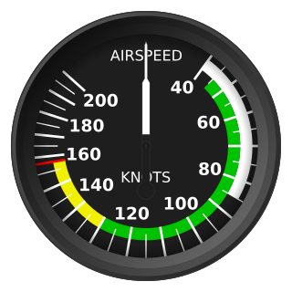
The barometric formula is a formula used to model how the pressure of the air changes with altitude.

In aviation, calibrated airspeed (CAS) is indicated airspeed corrected for instrument and position error.

<span class="mw-page-title-main">Density altitude</span> Altitude relative to standard atmospheric conditions

The density altitude is the altitude relative to standard atmospheric conditions at which the air density would be equal to the indicated air density at the place of observation. In other words, the density altitude is the air density given as a height above mean sea level. The density altitude can also be considered to be the pressure altitude adjusted for a non-standard temperature.

<span class="mw-page-title-main">U.S. Standard Atmosphere</span> Static atmospheric model

The U.S. Standard Atmosphere is a static atmospheric model of how the pressure, temperature, density, and viscosity of the Earth's atmosphere change over a wide range of altitudes or elevations. The model, based on an existing international standard, was first published in 1958 by the U.S. Committee on Extension to the Standard Atmosphere, and was updated in 1962, 1966, and 1976. It is largely consistent in methodology with the International Standard Atmosphere, differing mainly in the assumed temperature distribution at higher altitudes.

A reference atmospheric model describes how the ideal gas properties of an atmosphere change, primarily as a function of altitude, and sometimes also as a function of latitude, day of year, etc. A static atmospheric model has a more limited domain, excluding time. A standard atmosphere is defined by the World Meteorological Organization as "a hypothetical vertical distribution of atmospheric temperature, pressure and density which, by international agreement, is roughly representative of year-round, midlatitude conditions."

QFF is an aeronautical code Q code. It is the MSL pressure derived from local meteorological station conditions in accordance with meteorological practice. This is the altimeter setting that is intended to produce correct altitude indication on an altimeter at the actual sea level elevation, while QNH is intended to have no error at the station elevation.

<span class="mw-page-title-main">Surface weather observation</span> Fundamental data used for weather forecasts

Surface weather observations are the fundamental data used for safety as well as climatological reasons to forecast weather and issue warnings worldwide. They can be taken manually, by a weather observer, by computer through the use of automated weather stations, or in a hybrid scheme using weather observers to augment the otherwise automated weather station. The ICAO defines the International Standard Atmosphere (ISA), which is the model of the standard variation of pressure, temperature, density, and viscosity with altitude in the Earth's atmosphere, and is used to reduce a station pressure to sea level pressure. Airport observations can be transmitted worldwide through the use of the METAR observing code. Personal weather stations taking automated observations can transmit their data to the United States mesonet through the Citizen Weather Observer Program (CWOP), the UK Met Office through their Weather Observations Website (WOW), or internationally through the Weather Underground Internet site. A thirty-year average of a location's weather observations is traditionally used to determine the station's climate. In the US a network of Cooperative Observers make a daily record of summary weather and sometimes water level information.

<span class="mw-page-title-main">Atmospheric temperature</span> Physical quantity that expresses hot and cold in the atmosphere

Atmospheric temperature is a measure of temperature at different levels of the Earth's atmosphere. It is governed by many factors, including incoming solar radiation, humidity, and altitude. The abbreviation MAAT is often used for Mean Annual Air Temperature of a geographical location.

Vertical position or vertical location is a position along a vertical direction above or below a given vertical datum . Vertical distance or vertical separation is the distance between two vertical positions. Many vertical coordinates exist for expressing vertical position: depth, height, altitude, elevation, etc. Points lying on an equigeopotential surface are said to be on the same vertical level, as in a water level.

References

  1. International Organization for Standardization, Standard Atmosphere , ISO 2533:1975, 1975.
  2. 1 2 Gyatt, Graham (2006-01-14): "The Standard Atmosphere" Archived 2007-03-10 at the Wayback Machine . A mathematical model of the 1976 U.S. Standard Atmosphere.
  3. Auld, D.J.; Srinivas, K. (2008). "Properties of the Atmosphere". Archived from the original on 2013-06-09. Retrieved 2008-03-13.
  4. Batchelor, G. K., An Introduction to Fluid Dynamics, Cambridge Univ. Press, 1967.
  5. 1 2 3 U.S. Standard Atmosphere, 1962, U.S. Government Printing Office, Washington, D.C., 1962
  6. Mathworks atmosnonstd
  7. Manual of the ICAO Standard Atmosphere (extended to 80 kilometres (262 500 feet)) (Third ed.). International Civil Aviation Organization. 1993. ISBN   92-9194-004-6. Doc 7488-CD.
  8. Tennent, R. M. (1971). Science Data Book. Harlow: Oliver & Boyd. p. 79. ISBN   0050024876.
  9. U.S. Extension to the ICAO Standard Atmosphere, U.S. Government Printing Office, Washington, D.C., 1958
  10. U.S. Standard Atmosphere Supplements, 1966, U.S. Government Printing Office, Washington, D.C., 1966
  11. U.S. Standard Atmosphere, 1976, U.S. Government Printing Office, Washington, D.C., 1976 (Linked file is 17 MB)
  12. NASA, "U.S. Standard Atmosphere 1976" Archived 2006-05-13 at the Wayback Machine
  13. Tomasi, C.; Vitake, V.; De Santis, L.V. (1998). "Relative optical mass functions for air, water vapour, ozone and nitrogen dioxide in atmospheric models presenting different latitudinal and seasonal conditions". Meteorology and Atmospheric Physics. 65 (1): 11–30. Bibcode:1998MAP....65...11T. doi:10.1007/BF01030266. S2CID   123129752. …the ISO (International Organisation for Standardisation) Standard Atmosphere, 1972. This model is identical to the present Standard Atmospheres of ICAO (International Civil Aviation Organization) and WMO (World Meteorological Organization) up to a height of 32 km
  14. JB2008