List of places on land with elevations below sea level

Last updated

.mw-parser-output .legend{page-break-inside:avoid;break-inside:avoid-column}.mw-parser-output .legend-color{display:inline-block;min-width:1.25em;height:1.25em;line-height:1.25;margin:1px 0;text-align:center;border:1px solid black;background-color:transparent;color:black}.mw-parser-output .legend-text{}
Dead Sea depression that is below sea level Dead Sea depression.webp
   Dead Sea depression that is below sea level

This is a list of places on land below mean sea level.

Contents

Places artificially created such as tunnels, mines, basements, and dug holes, or places under water, or existing temporarily as a result of ebbing of sea tide etc., are not included. Places where seawater and rainwater is pumped away are included. Fully natural places below sea level require a dry climate; otherwise, rain would exceed evaporation and fill the area.

All figures are in meters below mean sea level (as locally defined), arranged by depth, lowest first:

Africa

#NameCountryDepthNotes / references
1 Lake Assal Djibouti −153 m (−502 ft)in Afar Depression: lowest land in Africa
2 Qattara Depression Egypt −133 m (−436 ft)
3 Danakil Depression Ethiopia −125 m (−410 ft)in Afar Depression
4 Sebkha Tah Morocco −55 m (−180 ft)in the Laâyoune-Boujdour-Sakia El Hamra region
5 Sabkhat Ghuzayyil Libya −47 m (−154 ft)
6 Lake Moeris Egypt −43 m (−141 ft)
7 Chott Melrhir Algeria −40 m (−131 ft)
8 Shatt al Gharsah Tunisia −17 m (−56 ft)
9 Sebkha de Ndrhamcha Mauritania −5 m (−16 ft)

Antarctica

#NameCountryDepthNotes / references
1canyon under Denman Glacier bedrock is at −3,500 m (−11,500 ft)This is the lowest natural point on land. [1] [2]
2 Byrd Glacier −2,780 m (−9,121 ft) [3]
3Deep Lake, Vestfold Hills −50 m (−164 ft)

Asia

#NameCountryDepthNotes / references
1 Dead Sea JordanWest BankIsrael −430 m (−1,411 ft)lowest land in Asia and the world 31°30′N35°30′E / 31.500°N 35.500°E / 31.500; 35.500 in Jordan valley, IsraelWest BankJordan
2 Allenby Bridge JordanWest Bank −381 m (−1,250 ft)lowest fixed water crossing in the world 31°52′27″N35°32′27″E / 31.87417°N 35.54083°E / 31.87417; 35.54083 in Jordan valley, IsraelWest BankJordan
3 Neot HaKikar Israel −345 m (−1,132 ft)Israeli town just south of the Dead Sea. 30°55′59.15″N35°22′36.11″E / 30.9330972°N 35.3766972°E / 30.9330972; 35.3766972 in Jordan valley, IsraelWest BankJordan
4 Jericho West Bank −258 m (−846 ft)lowest city in the world 31°51′N35°28′E / 31.85°N 35.46°E / 31.85; 35.46 in Jordan valley, IsraelWest BankJordan
5 Sea of Galilee Israel −214 m (−702 ft) 32°48′N35°36′E / 32.80°N 35.60°E / 32.80; 35.60 Jordan valley, IsraelWest BankJordan
6 Tiberias Israel −207 m (−679 ft) 32°47′48″N35°32′09″E / 32.7966°N 35.535717°E / 32.7966; 35.535717 Jordan valley, IsraelWest BankJordan
7 Turfan Depression China −154 m (−505 ft) [4]
8 Caspian Depression, Karagiye Kazakhstan −138 m (−453 ft)Caspian Basin
9 Bet She'an Israel −122 m (−400 ft) 32°30′N35°30′E / 32.50°N 35.50°E / 32.50; 35.50 (between Tiberias and Jericho) in Jordan valley, IsraelWest BankJordan
10 Caspian Sea and its shores RussiaKazakhstanAzerbaijanIranTurkmenistan −28 m (−92 ft)Caspian Basin
11 Hachirōgata Japan −4 m (−13 ft)
12 Kuttanad India −2 m (−7 ft)

Europe

2012-NL-prov-relief-3000.jpg
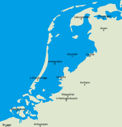
The Netherlands compared to sealevel.png
Areas of the Netherlands located above sea level (right) compared to dry land (left).
#NameCountryDepthNotes / references
1= Caspian Sea and its shores Azerbaijan, Russia, and Kazakhstan −28 m (−92 ft) Caspian Depression
1= Baku Azerbaijan −28 m (−92 ft)lowest lying national capital in the world, Caspian Depression
3 Atyrau Airport Kazakhstan −22 m (−72 ft)lowest international airport, Caspian Depression
4= Lammefjord Denmark −7 m (−23 ft)
4= Zuidplaspolder Netherlands −7 m (−23 ft)Netherlands coastal provinces (−1 to −7 m) (−3 to −23 ft)
6= Haarlemmermeer Netherlands −5 m (−16 ft)Netherlands coastal provinces (−1 to −7 m) (−3 to −23 ft)
6= Kuialnyk Estuary Ukraine −5 m (−16 ft) Odesa oblast
8= Amsterdam Schiphol Airport Netherlands −4 m (−13 ft)Netherlands coastal provinces (−1 to −7 m) (−3 to −23 ft)
8= Wieringermeer Netherlands −4 m (−13 ft)Netherlands coastal provinces (−1 to −7 m) (−3 to −23 ft)
8= Flevoland Netherlands −4 m (−13 ft)Netherlands coastal provinces (−1 to −7 m) (−3 to −23 ft)
8= Neuendorf-Sachsenbande Germany −4 m (−13 ft)
12 Le Contane, Jolanda di Savoia Italy −3.44 m (−11.3 ft)
13=parts of West Flanders Belgium −3 m (−10 ft)
13= North Slob, County Wexford Ireland −3 m (−10 ft)
15 The Fens United Kingdom −2.75 m (−9 ft)
16= Étang de Lavalduc France −2 m (−7 ft)
16= Amsterdam Netherlands −2 m (−7 ft)Netherlands coastal provinces (−1 to −7 m) (−3 to −23 ft)
16= Kristianstad Sweden −2 m (−7 ft)
16= Żuławy Wiślane Poland −2 m (−7 ft) Baltic delta of the Vistula River

North America

Sea level sign (2/3 of the way up the cliff face) above Badwater Basin, Death Valley National Park, USA BadwaterSL.JPG
Sea level sign (2/3 of the way up the cliff face) above Badwater Basin, Death Valley National Park, USA
#NameCountryDepthNotes / references
1 Badwater Basin, Death Valley, California United States−86 m (−282 ft) [5] lowest point in North America
2 Bombay Beach, California United States−69 m (−226 ft) Salton Sink −66 m (−217 ft)
3 Salton Sea Beach, California United States−67 m (−220 ft) Salton Sink −66 m (−217 ft)
4 Desert Shores, California United States−61 m (−200 ft) Salton Sink −66 m (−217 ft)
5 Calipatria, California United States−56 m (−184 ft) Salton Sink −66 m (−217 ft)
6 Westmorland, California United States−48 m (−157 ft) Salton Sink −66 m (−217 ft)
7 Lake Enriquillo Dominican Republic −46 m (−151 ft)lowest place on an island country.
8 Niland, California United States−43 m (−141 ft) Salton Sink −66 m (−217 ft)
9 Salton City, California United States−38 m (−125 ft) Salton Sink, −66 m (−217 ft)
10= Brawley, California United States−37 m (−121 ft) Salton Sink, −66 m (−217 ft)
10= Thermal, California United States−37 m (−121 ft) Salton Sink, −66 m (−217 ft)
12 Coachella, California United States−22 m (−72 ft) Salton Sink, −66 m (−217 ft)
13 Imperial, California United States−18 m (−59 ft) Salton Sink, −66 m (−217 ft)
14 Seeley, California United States−13 m (−43 ft) Salton Sink, −66 m (−217 ft)
15 El Centro, California United States−12 m (−39 ft) Salton Sink, −66 m (−217 ft)
16 Laguna Salada, Baja California Mexico −10 m (−33 ft)
17 Indio, California United States−6 m (−20 ft) Salton Sink, −66 m (−217 ft)
18 Heber, California United States−5 m (−16 ft) Salton Sink, −66 m (−217 ft)
19 Holtville, California United States−3 m (−10 ft) Salton Sink, −66 m (−217 ft)
20 New Orleans, Louisiana United States−2 m (−7 ft)

Oceania

#NameCountryDepthNotes / references
1 Lake Eyre Australia −16 m (−52 ft)lowest land in Australia
2 Lake Frome Australia −6 m (−20 ft)
3 Taieri Plain New Zealand −2 m (−7 ft)lowest land in New Zealand

South America

#NameCountryDepthNotes / references
1 Laguna del Carbón Argentina −105 m (−344 ft)lowest land in the Americas
2 Laguna del Puesto, Santa Cruz province, Argentina Argentina −75 m (−246 ft) [6]
3 Bajo del Gualicho, Río Negro province Argentina −72 m (−236 ft)
4 Salina Grande and Salina Chica, Valdés Peninsula, Chubut Province Argentina −42 m (−138 ft)
5 Sechura Depression, Sechura Desert, Piura Region Peru −34 m (−112 ft)
6 Georgetown, Guyana Guyana −2 m (−7 ft)[ citation needed ]

Historic and ice-covered areas

Deeper and larger than any of the trenches in the list above is the Bentley Subglacial Trench in Antarctica, at a depth of 2,540 m (8,330 ft). It is subglacial, covered permanently by the largest glacier in the world. Therefore, it is not included in any list on the page. If the ice melted it would be covered by sea.

The biggest dry land area below sea level that has been known to exist during the geological past, as measured by continuous volume of atmospheric air below sea level, was the dry bed of the Mediterranean Sea of the late Miocene period during the Messinian salinity crisis.

See also

Related Research Articles

<span class="mw-page-title-main">Geography of Antarctica</span>

The geography of Antarctica is dominated by its south polar location and, thus, by ice. The Antarctic continent, located in the Earth's southern hemisphere, is centered asymmetrically around the South Pole and largely south of the Antarctic Circle. It is washed by the Southern Ocean or, depending on definition, the southern Pacific, Atlantic, and Indian Oceans. It has an area of more than 14.2 million km2. Antarctica is the largest ice desert in the world.

<span class="mw-page-title-main">Climate of Antarctica</span> Overview of climactic conditions in Antarctica

The climate of Antarctica is the coldest on Earth. The continent is also extremely dry, averaging 166 mm (6.5 in) of precipitation per year. Snow rarely melts on most parts of the continent, and, after being compressed, becomes the glacier ice that makes up the ice sheet. Weather fronts rarely penetrate far into the continent, because of the katabatic winds. Most of Antarctica has an ice-cap climate with extremely cold and dry weather.

<span class="mw-page-title-main">Vostok Station</span> Russian research station in Antarctica

Vostok Station is a Russian research station in inland Princess Elizabeth Land, Antarctica. Founded by the Soviet Union in 1957, the station lies at the southern Pole of Cold, with the lowest reliably measured natural temperature on Earth of −89.2 °C. Research includes ice core drilling and magnetometry. Vostok was named after Vostok, the lead ship of the First Russian Antarctic Expedition captained by Fabian von Bellingshausen. The Bellingshausen Station was named after this captain.

This article lists extreme locations on Earth that hold geographical records or are otherwise known for their geophysical or meteorological superlatives. All of these locations are Earth-wide extremes; extremes of individual continents or countries are not listed.

<span class="mw-page-title-main">Topographic prominence</span> Vertical measurement of the independence of a summit

In topography, prominence or relative height measures the height of a mountain or hill's summit relative to the lowest contour line encircling it but containing no higher summit within it. It is a measure of the independence of a summit. The key col ("saddle") around the peak is a unique point on this contour line and the parent peak is some higher mountain, selected according to various criteria.

<span class="mw-page-title-main">Marie Byrd Land</span> Unclaimed West Antarctic region

Marie Byrd Land (MBL) is an unclaimed region of Antarctica. With an area of 1,610,000 km2 (620,000 sq mi), it is the largest unclaimed territory on Earth. It was named after the wife of American naval officer Richard E. Byrd, who explored the region in the early 20th century.

<span class="mw-page-title-main">Antarctic ice sheet</span> Earths southern polar ice cap

The Antarctic ice sheet is a continental glacier covering 98% of the Antarctic continent, with an area of 14 million square kilometres and an average thickness of over 2 kilometres (1.2 mi). It is the largest of Earth's two current ice sheets, containing 26.5 million cubic kilometres of ice, which is equivalent to 61% of all fresh water on Earth. Its surface is nearly continuous, and the only ice-free areas on the continent are the dry valleys, nunataks of the Antarctic mountain ranges, and sparse coastal bedrock. However, it is often subdivided into East Antarctic ice sheet (EAIS), West Antarctic ice sheet (WAIS), and Antarctic Peninsula (AP), due to the large differences in topography, ice flow, and glacier mass balance between the three regions.

This is a list of extreme points in Antarctica.

<span class="mw-page-title-main">Denman Glacier</span> Glacier in Queen Mary Land, Antarctica

Denman Glacier is a glacier 11 to 16 km wide, descending north some 110 km (70 mi), which debouches into the Shackleton Ice Shelf east of David Island, Queen Mary Land. It was discovered in November 1912 by the Western Base party of the Australasian Antarctic Expedition under Sir Douglas Mawson. Mawson named the glacier for Lord Denman, Governor-General of Australia in 1911, a patron of the expedition.

<span class="mw-page-title-main">Thwaites Glacier</span> Antarctic glacier

Thwaites Glacier is an unusually broad and vast Antarctic glacier located east of Mount Murphy, on the Walgreen Coast of Marie Byrd Land. It was initially sighted by polar researchers in 1940, mapped in 1959–1966 and officially named in 1967, after the late American glaciologist Fredrik T. Thwaites. The glacier flows into Pine Island Bay, part of the Amundsen Sea, at surface speeds which exceed 2 kilometres (1.2 mi) per year near its grounding line. Its fastest-flowing grounded ice is centered between 50 and 100 kilometres east of Mount Murphy. Like many other parts of the cryosphere, it has been adversely affected by climate change, and provides one of the more notable examples of the retreat of glaciers since 1850.

<span class="mw-page-title-main">Tunnel valley</span> Glacial-formed geographic feature

A tunnel valley is a U-shaped valley originally cut under the glacial ice near the margin of continental ice sheets such as that now covering Antarctica and formerly covering portions of all continents during past glacial ages. They can be as long as 100 km (62 mi), 4 km (2.5 mi) wide, and 400 m (1,300 ft) deep.

<span class="mw-page-title-main">Totten Glacier</span> Glacier in Antarctica

Totten Glacier is a large glacier draining a major portion of the East Antarctic Ice Sheet, through the Budd Coast of Wilkes Land in the Australian Antarctic Territory. The catchment drained by the glacier is estimated at 538,000 km2 (208,000 sq mi), extending approximately 1,100 km (680 mi) into the interior and holds the potential to raise sea level by at least 3.5 m (11 ft). Totten drains northeastward from the continental ice but turns northwestward at the coast where it terminates in a prominent tongue close east of Cape Waldron. It was first delineated from aerial photographs taken by USN Operation Highjump (1946–47), and named by Advisory Committee on Antarctic Names (US-ACAN) for George M. Totten, midshipman on USS Vincennes of the United States Exploring Expedition (1838–42), who assisted Lieutenant Charles Wilkes with correction of the survey data obtained by the expedition.

<span class="mw-page-title-main">East Antarctic Ice Sheet</span> Segment of the continental ice sheet that covers East Antarctica

The East Antarctic Ice Sheet (EAIS) lies between 45° west and 168° east longitudinally. It was first formed around 34 million years ago, and it is the largest ice sheet on the entire planet, with far greater volume than the Greenland ice sheet or the West Antarctic Ice Sheet (WAIS), from which it is separated by the Transantarctic Mountains. The ice sheet is around 2.2 km (1.4 mi) thick on average and is 4,897 m (16,066 ft) at its thickest point. It is also home to the geographic South Pole, South Magnetic Pole and the Amundsen–Scott South Pole Station.

<span class="mw-page-title-main">Blood Falls</span> Red-colored seep of saltwater flowing from Taylor Glacier in Antarctica

Blood Falls is an outflow of an iron oxide–tainted plume of saltwater, flowing from the tongue of Taylor Glacier onto the ice-covered surface of West Lake Bonney in the Taylor Valley of the McMurdo Dry Valleys in Victoria Land, East Antarctica.

Byrd Subglacial Basin is a major subglacial basin of West Antarctica, extending east–west between the Crary Mountains and the Ellsworth Mountains. It is bounded to the south by a low subglacial ridge which separates this feature from Bentley Subglacial Trench. A crude delineation of this subglacial basin was determined by several U.S. seismic parties operating from Byrd Station, Little America V, and Ellsworth Station during the 1950s and 1960s. It was named by the Advisory Committee on Antarctic Names (1961) for its locus relative to Marie Byrd Land and Byrd Station.

<span class="mw-page-title-main">Overdeepening</span> Characteristic of basins and valleys eroded by glaciers

Overdeepening is a characteristic of basins and valleys eroded by glaciers. An overdeepened valley profile is often eroded to depths which are hundreds of metres below the lowest continuous surface line along a valley or watercourse. This phenomenon is observed under modern day glaciers, in salt-water fjords and fresh-water lakes remaining after glaciers melt, as well as in tunnel valleys which are partially or totally filled with sediment. When the channel produced by a glacier is filled with debris, the subsurface geomorphic structure is found to be erosionally cut into bedrock and subsequently filled by sediments. These overdeepened cuts into bedrock structures can reach a depth of several hundred metres below the valley floor.

<span class="mw-page-title-main">Ice cap climate</span> Polar climate where no mean monthly temperature exceeds 0 °C (32 °F)

An ice cap climate is a polar climate where no mean monthly temperature exceeds 0 °C (32 °F). The climate generally covers areas at high altitudes and polar regions, such as Antarctica and some of the northernmost islands of Canada and Russia. Most of Greenland is under the influence of an ice cap climate, although the coasts are prone to more influence from the sea, providing more tundra climates. Some regions on the islands of Norway's Svalbard Archipelago facilitate an ice cap climate. Areas with ice cap climates are normally covered by a permanent layer of ice and have no vegetation. There is limited animal life in most ice cap climates, which are usually found near the oceanic margins. Although ice cap climates are inhospitable to human life and no civilian communities lie in such climates, there are some research stations scattered in Antarctica and interior Greenland.

<span class="mw-page-title-main">Macheret Trench</span>

Macheret Trench is the narrow, elongated subglacial valley reaching a maximum depth of 120 m below sea level beneath upper Perunika Glacier on Livingston Island in the South Shetland Islands, Antarctica. From its deepest section at 62°36'38.0"S by 60°15'55.0"W, situated north of Rezen Knoll, the feature extends below sea level 3.8 km in southeast direction to near Wörner Gap.

<span class="mw-page-title-main">Global relief model</span> Model of Earths relief including elevation and depth underwater

A global relief model, sometimes also denoted as global topography model or composite model, combines digital elevation model (DEM) data over land with digital bathymetry model (DBM) data over water-covered areas to describe Earth's relief. A relief model thus shows how Earth's surface would look like in the absence of water or ice masses.

References

  1. Jonathan Amos (December 12, 2019). "Denman Glacier: Deepest point on land found in Antarctica". BBC . Retrieved December 13, 2019.
  2. Mathieu Morlighem; Eric Rignot; Tobias Binder; Donald Blankenship; Reinhard Drews; Graeme Eagles; Olaf Eisen; Fausto Ferraccioli; René Forsberg; Peter Fretwell; Vikram Goel; Jamin S. Greenbaum; Hilmar Gudmundsson; Jingxue Guo; Veit Helm; Coen Hofstede; Ian Howat; Angelika Humbert; Wilfried Jokat; Nanna B. Karlsson; Won Sang Lee; Kenichi Matsuoka; Romain Millan; Jeremie Mouginot; John Paden; Frank Pattyn; Jason Roberts; Sebastian Rosier; Antonia Ruppel; Helene Seroussi; Emma C. Smith; Daniel Steinhage; Bo Sun; Michiel R. van den Broeke; Tas D. van Ommen; Melchior van Wessem; Duncan A. Young (2019-12-12). "Deep glacial troughs and stabilizing ridges unveiled beneath the margins of the Antarctic ice sheet". Nature Geoscience . 13 (2): 132–137. Bibcode:2019NatGe..13..132M. doi:10.1038/s41561-019-0510-8. S2CID   209331991 . Retrieved 2019-12-13.
  3. "News Story – Bedmap2 gives scientists a more detailed view of Antarctica's landmass". News Story – Bedmap2 gives scientists a more detailed view of Antarctica’s landmass. NERC BASS. 8 March 2013. Archived from the original on 21 July 2015. Retrieved 1 May 2015.
  4. Scheffel, Richard L.; Wernet, Susan J., eds. (1980). Natural Wonders of the World. United States of America: Reader's Digest Association, Inc. p. 378. ISBN   0-89577-087-3.
  5. "Highest and Lowest Elevations". United States Geological Survey . Retrieved April 29, 2021.
  6. "LAGUNA DEL PUESTO Geography Population Map cities coordinates location - Tageo.com". www.tageo.com.