The Afar Triangle is a geological depression caused by the Afar triple junction, which is part of the Great Rift Valley in East Africa. The region has disclosed fossil specimens of the very earliest hominins; that is, the earliest of the human clade, and it is thought by some paleontologists to be the cradle of the evolution of humans. The Depression overlaps the borders of Eritrea, Djibouti and the entire Afar Region of Ethiopia; and it contains the lowest point in Africa, Lake Assal, Djibouti, at 155 m (509 ft) below sea level.

The Danakil Desert is a desert in northeast Ethiopia, southern Eritrea, and northwestern Djibouti. Situated in the Afar Triangle, it stretches across 136,956 square kilometres (52,879 sq mi) of arid terrain. It is inhabited by a few Afar, who engage in salt mining. The area is known for its volcanoes and extreme heat, with daytime temperatures surpassing 50 °C (122 °F). Less than 25 mm (1 in) of rainfall occurs each year. The Danakil Desert is one of the lowest and hottest places on Earth.

Lake Abbe, also known as Lake Abhe Bad, is a salt lake, lying on the Ethiopia-Djibouti border. It is one of a chain of six connected lakes, which also includes lakes Gargori, Laitali, Gummare, Bario and Afambo. The lake is the ultimate destination of the Awash River, which is at the center of the Afar Triangle. Lake Abbe is considered one of the most inaccessible areas of the earth. The water itself is known for its flamingos.

The Afar Region, formerly known as Region 2, is a regional state in northeastern Ethiopia and the homeland of the Afar people. Its capital is the planned city of Semera, which lies on the paved Awash–Assab highway. It is bordered by Eritrea to the north and Djibouti to the northeast; it also shares regional borders with the Tigray, Amhara, Oromo and Somali regions.

Lake Assal is a crater lake in central-western Djibouti. It is located at the western end of Gulf of Tadjoura between Arta Region, and Tadjoura Region, touching Dikhil Region, at the top of the Great Rift Valley, some 120 km (75 mi) west of Djibouti city. Lake Assal is a saline lake that lies 155 m (509 ft) below sea level in the Afar Triangle, making it the lowest point on land in Africa and the third-lowest point on Earth after the Sea of Galilee and the Dead Sea. No outflow occurs from the lake, and due to high evaporation, the salinity level of its waters is 10 times that of the sea, making it the fifth most saline body of water in the world, behind Garabogazköl, Lake Retba, and Gaet'ale Pond. The salt in the lake is exploited under four concessions awarded in 2002 at the southeast end of the lake; the major share of production is held by Société d’Exploitation du Lac and Société d’Exploitation du Salt Investment S.A de Djibouti.

Dallol is a locality in the Dallol woreda of northern Ethiopia. Located in Kilbet Rasu, Afar Region in the Afar Depression, it has a latitude and longitude of 14°14′19″N40°17′38″E with an elevation of about 130 metres (430 ft) below sea level. The Central Statistical Agency has not published an estimate for the 2005 population of the village, which has been described as a ghost town.

Lake Afrera is a hypersaline lake in northern Ethiopia. Located in Kilbet Rasu, Afar Region, it is one of the lakes of the Danakil Depression. According to its entry in Lakenet, it has a surface area of 100 km2 (39 sq mi), although another source states the area is 125 km2 (48 sq mi). An unconfirmed report gives its depth as 160 m (525 ft); the lake is fed by underground streams.

Erta Ale is a continuously active basaltic shield volcano in the Afar Region of northeastern Ethiopia, which is itself part of the wider Afar Triangle. The volcano is located in the Danakil Depression, an area on the border between Ethiopia and Eritrea that is below sea level. It is the most active of the volcanoes in Ethiopia.
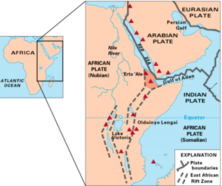
The Afar triple junction is located along a divergent plate boundary dividing the Nubian, Somali, and Arabian plates. This area is considered a present-day example of continental rifting leading to seafloor spreading and producing an oceanic basin. Here, the Red Sea Rift meets the Aden Ridge and the East African Rift. The latter extends a total of 6,500 kilometers (4,000 mi) from the Afar Triangle to Mozambique.

A hypersaline lake is a landlocked body of water that contains significant concentrations of sodium chloride, brines, and other salts, with saline levels surpassing those of ocean water.

The Djibouti xeric shrublands is an ecoregion defined by One Earth, consisting of a semi-desert strip on or near the Red Sea and the Gulf of Aden coasts in Eritrea, Ethiopia, Djibouti and Somalia. This ecoregion lies mainly between sea level and 800 meters (m) elevation. There are, however, many hills and massifs, which range up to 1300 m as well as outstanding fault-induced depressions, such as the Danakil, lying as low as 155 m below sea level. This region is extremely active tectonically, experiencing many earthquakes and intermittently active volcanoes. Rainfall is very low and yearly averages range from 100 to 200 millimeters (mm), with less rain falling closer to the coast. There are many species of interest, including the endemic Archer's lark, a species of dragon tree, and a large suite of desert ungulates, including the last viable population of African wild ass.

A soda lake or alkaline lake is a lake on the strongly alkaline side of neutrality, typically with a pH value between 9 and 12. They are characterized by high concentrations of carbonate salts, typically sodium carbonate, giving rise to their alkalinity. In addition, many soda lakes also contain high concentrations of sodium chloride and other dissolved salts, making them saline or hypersaline lakes as well. High pH and salinity often coincide, because of how soda lakes develop. The resulting hypersaline and highly alkalic soda lakes are considered some of the most extreme aquatic environments on Earth.

Jon Kalb August 17, 1941 - October 27, 2017 was a research geologist with the Vertebrate Paleontology Laboratory, University of Texas at Austin. He received a pre-doctoral fellowship from the Carnegie Geophysical Laboratory in 1968, a graduate fellowship from Johns Hopkins University in 1969, and a BSc from American University in 1970.
Nanohaloarchaea is a clade of diminutive archaea with small genomes and limited metabolic capabilities, belonging to the DPANN archaea. They are ubiquitous in hypersaline habitats, which they share with the extremely halophilic haloarchaea.
The geology of Eritrea in east Africa broadly consists of Precambrian rocks in the west, Paleozoic glacial sedimentary rocks in the South and Cenozoic sediments and volcanics along the coastal zone adjoining the Red Sea. The Precambrian rocks been involved with the orogeny process, which is when a section of the Earth's crust is deformed to form a mountain range. Mesozoic sediments in the Danakil and Aysha horsts, which are raised blocks of the Earth's crust that have been lifted, were deformed. The older rocks include meta-sediments and older gneissic basement belonging to different Proterozoic terranes. Mesozoic sediments of marine origin occur in the coastal area along the Red Sea. A number of thin Miocene age basalt flows occur within the sediments of this zone whilst the basalts of the Aden Series date from Pliocene to Holocene times, some being extruded at the time of a major phase of uplift and rifting during the Pleistocene.
The Danakil Alps are a highland region in Ethiopia and Eritrea with peaks over 1000 metres in height and a width varying between 40 and 70 kilometres. The area is known in the Afar language as Arrata. The alps lie along the southern Red Sea to the east of the Danakil Depression and separate it from the sea. The alps are asymmetric in cross-section with a comparatively gentle rift escarpment facing the Red Sea and intense normal faulting on the inland side.

Gaet'ale Pond is a small hypersaline lake located near the Dallol crater in the Danakil Depression. It is located over a hot spring of tectonic origin and has no apparent inlet or outlet streams. The water of Gaet'ale Pond has a salinity of 43%, making it the saltiest water body on Earth.
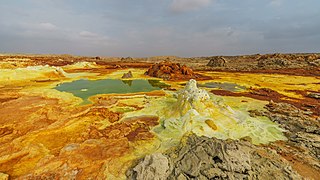
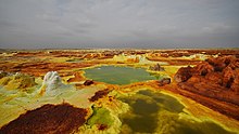
Dallol is a unique, terrestrial hydrothermal system around a cinder cone volcano in the Danakil Depression, northeast of the Erta Ale Range in Ethiopia. It is known for its unearthly colors and mineral patterns, and the very acidic fluids that discharge from its hydrothermal springs.