The ionosphere is the ionized part of the upper atmosphere of Earth, from about 48 km (30 mi) to 965 km (600 mi) above sea level, a region that includes the thermosphere and parts of the mesosphere and exosphere. The ionosphere is ionized by solar radiation. It plays an important role in atmospheric electricity and forms the inner edge of the magnetosphere. It has practical importance because, among other functions, it influences radio propagation to distant places on Earth. It also affects GPS signals that travel through this layer.

The mesosphere is the third layer of the atmosphere, directly above the stratosphere and directly below the thermosphere. In the mesosphere, temperature decreases as altitude increases. This characteristic is used to define limits: it begins at the top of the stratosphere, and ends at the mesopause, which is the coldest part of Earth's atmosphere, with temperatures below −143 °C. The exact upper and lower boundaries of the mesosphere vary with latitude and with season, but the lower boundary is usually located at altitudes from 50 to 65 km above sea level, and the upper boundary is usually from 85 to 100 km.

The thermosphere is the layer in the Earth's atmosphere directly above the mesosphere and below the exosphere. Within this layer of the atmosphere, ultraviolet radiation causes photoionization/photodissociation of molecules, creating ions; the thermosphere thus constitutes the larger part of the ionosphere. Taking its name from the Greek θερμός meaning heat, the thermosphere begins at about 80 km (50 mi) above sea level. At these high altitudes, the residual atmospheric gases sort into strata according to molecular mass. Thermospheric temperatures increase with altitude due to absorption of highly energetic solar radiation. Temperatures are highly dependent on solar activity, and can rise to 2,000 °C (3,630 °F) or more. Radiation causes the atmospheric particles in this layer to become electrically charged, enabling radio waves to be refracted and thus be received beyond the horizon. In the exosphere, beginning at about 600 km (375 mi) above sea level, the atmosphere turns into space, although, by the judging criteria set for the definition of the Kármán line (100 km), most of the thermosphere is part of space. The border between the thermosphere and exosphere is known as the thermopause.
The mesopause is the point of minimum temperature at the boundary between the mesosphere and the thermosphere atmospheric regions. Due to the lack of solar heating and very strong radiative cooling from carbon dioxide, the mesosphere is the coldest region on Earth with temperatures as low as -100 °C. The altitude of the mesopause for many years was assumed to be at around 85 km (53 mi), but observations to higher altitudes and modeling studies in the last 10 years have shown that in fact there are two mesopauses - one at about 85 km and a stronger one at about 100 km (62 mi), with a layer of slightly warmer air between them.

Space weather is a branch of space physics and aeronomy, or heliophysics, concerned with the time varying conditions within the Solar System, including the solar wind, emphasizing the space surrounding the Earth, including conditions in the magnetosphere, ionosphere, thermosphere, and exosphere. Space weather is distinct from, but conceptually related to, the terrestrial weather of the atmosphere of Earth. The term "space weather" was first used in the 1950s and came into common usage in the 1990s. Later, it was generalized to a "space climate" research discipline, which focuses on general behaviors of longer and larger-scale variabilities and effects.

The atmosphere of Earth is the layer of gases, known collectively as air, retained by Earth's gravity that surrounds the planet and forms its planetary atmosphere. The atmosphere of Earth creates pressure, absorbs most meteoroids and ultraviolet solar radiation, warms the surface through heat retention, allowing life and liquid water to exist on the Earth's surface, and reduces temperature extremes between day and night.

The International Standard Atmosphere (ISA) is a static atmospheric model of how the pressure, temperature, density, and viscosity of the Earth's atmosphere change over a wide range of altitudes or elevations. It has been established to provide a common reference for temperature and pressure and consists of tables of values at various altitudes, plus some formulas by which those values were derived. The International Organization for Standardization (ISO) publishes the ISA as an international standard, ISO 2533:1975. Other standards organizations, such as the International Civil Aviation Organization (ICAO) and the United States Government, publish extensions or subsets of the same atmospheric model under their own standards-making authority.

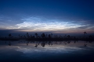
Noctilucent clouds, or night shining clouds, are tenuous cloud-like phenomena in the upper atmosphere of Earth. When viewed from space, they are called polar mesospheric clouds (PMCs), detectable as a diffuse scattering layer of water ice crystals near the summer polar mesopause. They consist of ice crystals and from the ground are only visible during astronomical twilight. Noctilucent roughly means "night shining" in Latin. They are most often observed during the summer months from latitudes between ±50° and ±70°. Too faint to be seen in daylight, they are visible only when the observer and the lower layers of the atmosphere are in Earth's shadow, but while these very high clouds are still in sunlight. Recent studies suggest that increased atmospheric methane emissions produce additional water vapor once the methane molecules reach the mesosphere – creating, or reinforcing existing noctilucent clouds.

The TIMED mission is dedicated to study the influences energetics and dynamics of the Sun and humans on the least explored and understood region of Earth's atmosphere – the Mesosphere and Lower Thermosphere / Ionosphere (MLTI). The mission was launched from Vandenberg Air Force Base in California on 7 December 2001 aboard a Delta II rocket launch vehicle. The project is sponsored and managed by NASA, while the spacecraft was designed and assembled by the Applied Physics Laboratory at Johns Hopkins University. The mission has been extended several times, and has now collected data over an entire solar cycle, which helps in its goal to differentiate the Sun's effects on the atmosphere from other effects. TIMED Was Launched Alongside Jason-1.
The Committee on Space Research (COSPAR) was established on October 3, 1958 by the International Council for Scientific Unions (ICSU). Among COSPAR's objectives are the promotion of scientific research in space on an international level, with emphasis on the free exchange of results, information, and opinions, and providing a forum, open to all scientists, for the discussion of problems that may affect space research. These objectives are achieved through the organization of symposia, publication, and other means. COSPAR has created a number of research programmes on different topics, a few in cooperation with other scientific Unions. The long-term project COSPAR international reference atmosphere started in 1960; since then it has produced several editions of the high-atmosphere code CIRA. The code "IRI" of the URSI-COSPAR working group on the International Reference Ionosphere was first edited in 1978 and is yearly updated.

Aeronomy is the scientific study of the upper atmosphere of the Earth and corresponding regions of the atmospheres of other planets. It is a branch of both atmospheric chemistry and atmospheric physics. Scientists specializing in aeronomy, known as aeronomers, study the motions and chemical composition and properties of the Earth's upper atmosphere and regions of the atmospheres of other planets that correspond to it, as well as the interaction between upper atmospheres and the space environment. In atmospheric regions aeronomers study, chemical dissociation and ionization are important phenomena.

The atmosphere of Mars is the layer of gases surrounding Mars. It is primarily composed of carbon dioxide (95%), molecular nitrogen (2.8%), and argon (2%). It also contains trace levels of water vapor, oxygen, carbon monoxide, hydrogen, and noble gases. The atmosphere of Mars is much thinner than Earth's. The average surface pressure is only about 610 pascals (0.088 psi) which is less than 1% of the Earth's value. The currently thin Martian atmosphere prohibits the existence of liquid water on the surface of Mars, but many studies suggest that the Martian atmosphere was much thicker in the past. The higher density during spring and fall is reduced by 25% during the winter when carbon dioxide partly freezes at the pole caps. The highest atmospheric density on Mars is equal to the density found 35 km (22 mi) above the Earth's surface and is ≈0.020 kg/m3. The atmosphere of Mars has been losing mass to space since the planet's core slowed down, and the leakage of gases still continues today.
A reference atmospheric model describes how the ideal gas properties of an atmosphere change, primarily as a function of altitude, and sometimes also as a function of latitude, day of year, etc. A static atmospheric model has a more limited domain, excluding time. A standard atmosphere is defined by the World Meteorological Organization as "a hypothetical vertical distribution of atmospheric temperature, pressure and density which, by international agreement, is roughly representative of year-round, midlatitude conditions."

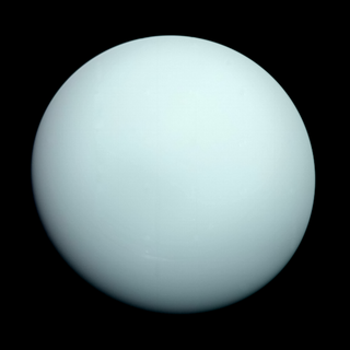
The atmosphere of Uranus is composed primarily of hydrogen and helium. At depth it is significantly enriched in volatiles such as water, ammonia and methane. The opposite is true for the upper atmosphere, which contains very few gases heavier than hydrogen and helium due to its low temperature. Uranus's atmosphere is the coldest of all the planets, with its temperature reaching as low as 49 K.

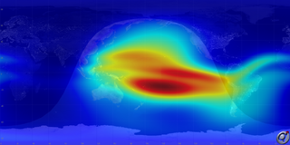
International Reference Ionosphere (IRI) is a common permanent scientific project of the Committee on Space Research (COSPAR) and the International Union of Radio Science (URSI) started 1968/69. It is the international standard empirical model for the terrestrial ionosphere since 1999. For a specified geographic location, time, and date, IRI provides average monthly values for electron density, electron temperature and ion temperature, and the molecular composition of the ions in the range of altitudes from 50 km to 2000 km. The latest standard is IRI-2012. A new version, IRI-2016, has since been released. The IRI has been extended to plasmasphere in the IRI-Plas model.

Explorer 9, known as S-56A before launch, was a NASA satellite which was launched in February 1961 to study the density and composition of the upper thermosphere and lower exosphere. It was a reflight of the failed Explorer S-56 mission, and consisted of a 7 kg (15 lb), 3.66 m (12.0 ft) balloon which was deployed into a medium Earth orbit. The mission was conducted by NASA's Langley Research Center.

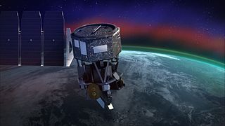
Ionospheric Connection Explorer (ICON) is a satellite designed to investigate changes in the ionosphere of Earth, the dynamic region high in our atmosphere where terrestrial weather from below meets space weather from above. ICON studies the interaction between Earth's weather systems and space weather driven by the Sun, and how this interaction drives turbulence in the upper atmosphere. It is hoped that a better understanding of this dynamic will mitigate its effects on communications, GPS signals, and technology in general. It is part of NASA's Explorer program and is operated by University of California, Berkeley's Space Sciences Laboratory.

Global-scale Observations of the Limb and Disk (GOLD) is a heliophysics Mission of Opportunity (MOU) for NASA's Explorers program. Led by Richard Eastes at the Laboratory for Atmospheric and Space Physics, which is located at the University of Colorado Boulder, GOLD's mission is to image the boundary between Earth and space in order to answer questions about the effects of solar and atmospheric variability of Earth's space weather. GOLD was one of 11 proposals selected, of the 42 submitted, for further study in September 2011. On 12 April 2013, NASA announced that GOLD, along with the Ionospheric Connection Explorer (ICON), had been selected for flight in 2017. GOLD, along with its commercial host satellite SES-14, launched on 25 January 2018.

Student Nitric Oxide Explorer, was a NASA small scientific satellite which studied the concentration of nitric oxide in the thermosphere. It was launched in 1998 as part of NASA's Explorer program. The satellite was the first of three missions developed within the Student Explorer Demonstration Initiative (STEDI) program funded by the NASA and managed by the Universities Space Research Association (USRA). STEDI was a pilot program to demonstrate that high-quality space science can be carried out with small, low-cost free-flying satellites on a time scale of two years from go-ahead to launch. The satellite was developed by the University of Colorado Boulder's Laboratory for Atmospheric and Space Physics (LASP) and had met its goals by the time its mission ended with reentry in December 2003.


