Quasi-biennial oscillation

Last updated

The quasi-biennial oscillation (QBO) is a quasiperiodic oscillation of the equatorial zonal wind between easterlies and westerlies in the tropical stratosphere with a mean period of 28 to 29 months. The alternating wind regimes develop at the top of the lower stratosphere and propagate downwards at about 1 km (0.6 mi) per month until they are dissipated at the tropical tropopause. Downward motion of the easterlies is usually more irregular than that of the westerlies. The amplitude of the easterly phase is about twice as strong as that of the westerly phase. At the top of the vertical QBO domain, easterlies dominate, while at the bottom, westerlies are more likely to be found. At the 30mb level, with regards to monthly mean zonal winds, the strongest recorded easterly was 29.55 m/s in November 2005, while the strongest recorded westerly was only 15.62 m/s in June 1995.

Contents

Theory

In 1883, the eruption of Krakatoa led to visual tracking of subsequent volcanic ash in the stratosphere. This visual tracking led to the discovery of easterly winds between 25 and 30 km above the surface. The winds were then called the Krakatau easterlies. In 1908, data balloons launched above Lake Victoria in Africa recorded westerly winds in the stratospheric levels of the atmosphere. These findings, at the time, were thought to contradict the 1883 findings. [1] However, the winds that would become known as the QBO were discovered to oscillate between westerly and easterly in the 1950s by researchers at the UK Meteorological Office. [2] The cause of these QBO winds remained unclear for some time. Radiosonde soundings showed that its phase was not related to the annual cycle, as is the case for many other stratospheric circulation patterns. In the 1970s it was recognized by Richard Lindzen and James Holton that the periodic wind reversal was driven by atmospheric waves emanating from the tropical troposphere that travel upwards and are dissipated in the stratosphere by radiative cooling. The precise nature of the waves responsible for this effect was heavily debated; in recent years, however, gravity waves have come to be seen as a major contributor and the QBO is now simulated in a growing number of climate models. [3] [4] [5]

Effects

Effects of the QBO include mixing of stratospheric ozone by the secondary circulation caused by the QBO, modification of monsoon precipitation, and an influence on stratospheric circulation in northern hemisphere winter (mediated partly by a change in the frequency of sudden stratospheric warmings). Easterly phases of the QBO often coincide with more sudden stratospheric warmings, a weaker Atlantic jet stream and cold winters in Northern Europe and eastern USA whereas westerly phases of the QBO often coincide with mild winters in eastern USA and a strong Atlantic jet stream with mild, wet stormy winters in northern Europe. [6] In addition, the QBO has been shown to affect hurricane frequency during hurricane seasons in the Atlantic. [7] Research has also been conducted investigating a possible relationship between ENSO (El Niño–Southern Oscillation) and the QBO. [8]

Observation of the QBO with weather balloons

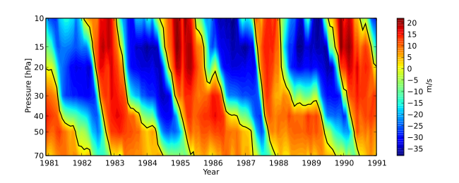
The Free University of Berlin supplies a QBO data set that comprises radiosonde observations from Canton Island, Gan, and Singapore. The plot below shows the QBO during the 1980s.

Time-height plot of monthly-mean, zonal-mean equatorial zonal wind (u) in m/s between about 20 and 35 km (22 mi) altitude above sea level over a ten-year period. Positive values denote westerly winds and the contour line is at 0 m/s. QBO Cycle observed.svg
Timeheight plot of monthly-mean, zonal-mean equatorial zonal wind (u) in m/s between about 20 and 35 km (22 mi) altitude above sea level over a ten-year period. Positive values denote westerly winds and the contour line is at 0 m/s.

Recent observations

The first significant observed deviation from the normal QBO since its discovery in early 1950s was noted beginning in February 2016 when the transition to easterly winds was disrupted by a new band of westerly winds that formed unexpectedly. The lack of a reliable QBO cycle deprives forecasters of a valuable tool. Since the QBO has a strong influence on the North Atlantic Oscillation and thereby north European weather, scientists speculated that the coming winter could be warmer and stormier in that region. [9] [10] [11] NASA scientists have been researching to test if the extremely strong El Niño event of 2015/16, climate change, or some other factor might be involved. They are trying to determine if this is more of a once in a generation event, or if this is a sign of the changing climate. [12]

See also

Related Research Articles

<span class="mw-page-title-main">El Niño</span> Warm phase of a cyclic climatic phenomenon in the Pacific Ocean

El Niño is the warm phase of the El Niño–Southern Oscillation (ENSO) and is associated with a band of warm ocean water that develops in the central and east-central equatorial Pacific, including the area off the Pacific coast of South America. The ENSO is the cycle of warm and cold sea surface temperature (SST) of the tropical central and eastern Pacific Ocean.

<span class="mw-page-title-main">Jet stream</span> Fast-flowing atmospheric air current

Jet streams are fast flowing, narrow, meandering air currents in the atmospheres of some planets, including Earth. On Earth, the main jet streams are located near the altitude of the tropopause and are westerly winds. Jet streams may start, stop, split into two or more parts, combine into one stream, or flow in various directions including opposite to the direction of the remainder of the jet.

<span class="mw-page-title-main">La Niña</span> Coupled ocean-atmosphere phenomenon that is the counterpart of El Niño

La Niña is an oceanic and atmospheric phenomenon that is the colder counterpart of El Niño, as part of the broader El Niño–Southern Oscillation (ENSO) climate pattern. The name La Niña originates from Spanish for "the girl", by analogy to El Niño, meaning "the boy". In the past, it was also called an anti-El Niño and El Viejo, meaning "the old man."

A sudden stratospheric warming (SSW) is an event in which polar stratospheric temperatures rise by several tens of kelvins over the course of a few days. The warming is preceded by a slowing then reversal of the westerly winds in the stratospheric polar vortex. SSWs occur about six times per decade in the northern hemisphere, and about once every 20-30 years in the southern hemisphere. Only two southern SSWs have been observed.

Richard Siegmund Lindzen is an American atmospheric physicist known for his work in the dynamics of the middle atmosphere, atmospheric tides, and ozone photochemistry. He has published more than 200 scientific papers and books. From 1983 until his retirement in 2013, he was Alfred P. Sloan Professor of Meteorology at the Massachusetts Institute of Technology. He has disputed the scientific consensus on climate change and criticizes what he has called "climate alarmism."

<span class="mw-page-title-main">El Niño–Southern Oscillation</span> Physical oceanography

El Niño–Southern Oscillation (ENSO) is an irregular periodic variation in winds and sea surface temperatures over the tropical eastern Pacific Ocean, affecting the climate of much of the tropics and subtropics. The warming phase of the sea temperature is known as El Niño and the cooling phase as La Niña. The Southern Oscillation is the accompanying atmospheric component, coupled with the sea temperature change: El Niño is accompanied by high air surface pressure in the tropical western Pacific and La Niña with low air surface pressure there. The two periods last several months each and typically occur every few years with varying intensity per period.

The North Atlantic Oscillation (NAO) is a weather phenomenon over the North Atlantic Ocean of fluctuations in the difference of atmospheric pressure at sea level (SLP) between the Icelandic Low and the Azores High. Through fluctuations in the strength of the Icelandic Low and the Azores High, it controls the strength and direction of westerly winds and location of storm tracks across the North Atlantic.

<span class="mw-page-title-main">Antarctic oscillation</span> Climatic cycle over the Southern Ocean

The Antarctic oscillation, also known as the Southern Annular Mode (SAM), is a low-frequency mode of atmospheric variability of the southern hemisphere that is defined as a belt of strong westerly winds or low pressure surrounding Antarctica which moves north or south as its mode of variability.

<span class="mw-page-title-main">Pacific decadal oscillation</span> Recurring pattern of climate variability

The Pacific decadal oscillation (PDO) is a robust, recurring pattern of ocean-atmosphere climate variability centered over the mid-latitude Pacific basin. The PDO is detected as warm or cool surface waters in the Pacific Ocean, north of 20°N. Over the past century, the amplitude of this climate pattern has varied irregularly at interannual-to-interdecadal time scales. There is evidence of reversals in the prevailing polarity of the oscillation occurring around 1925, 1947, and 1977; the last two reversals corresponded with dramatic shifts in salmon production regimes in the North Pacific Ocean. This climate pattern also affects coastal sea and continental surface air temperatures from Alaska to California.

<span class="mw-page-title-main">Polar vortex</span> Persistent cold-core low-pressure area that circles one of the poles

A circumpolar vortex, or simply polar vortex, is a large region of cold, rotating air that encircles both of Earth's polar regions. Polar vortices also exist on other rotating, low-obliquity planetary bodies. The term polar vortex can be used to describe two distinct phenomena; the stratospheric polar vortex, and the tropospheric polar vortex. The stratospheric and tropospheric polar vortices both rotate in the direction of the Earth's spin, but they are distinct phenomena that have different sizes, structures, seasonal cycles, and impacts on weather.

The South Pacific Convergence Zone (SPCZ), a reverse-oriented monsoon trough, is a band of low-level convergence, cloudiness and precipitation extending from the Western Pacific Warm Pool at the maritime continent south-eastwards towards French Polynesia and as far as the Cook Islands. The SPCZ is a portion of the Intertropical Convergence Zone (ITCZ) which lies in a band extending east–west near the Equator but can be more extratropical in nature, especially east of the International Date Line. It is considered the largest and most important piece of the ITCZ, and has the least dependence upon heating from a nearby landmass during the summer than any other portion of the monsoon trough. The SPCZ can affect the precipitation on Polynesian islands in the southwest Pacific Ocean, so it is important to understand how the SPCZ behaves with large-scale, global climate phenomenon, such as the ITCZ, El Niño–Southern Oscillation, and the Interdecadal Pacific oscillation (IPO), a portion of the Pacific decadal oscillation.

<span class="mw-page-title-main">Western Hemisphere Warm Pool</span>

The Western Hemisphere Warm Pool (WHWP) is a region of sea surface temperatures (SST) warmer than 28.5 °C that develops west of Central America in the spring, then expands to the tropical waters to the east.

<span class="mw-page-title-main">Madden–Julian oscillation</span> Tropical atmosphere element of variability

The Madden–Julian oscillation (MJO) is the largest element of the intraseasonal variability in the tropical atmosphere. It was discovered in 1971 by Roland Madden and Paul Julian of the American National Center for Atmospheric Research (NCAR). It is a large-scale coupling between atmospheric circulation and tropical deep atmospheric convection. Unlike a standing pattern like the El Niño–Southern Oscillation (ENSO), the Madden–Julian oscillation is a traveling pattern that propagates eastward, at approximately 4 to 8 m/s, through the atmosphere above the warm parts of the Indian and Pacific oceans. This overall circulation pattern manifests itself most clearly as anomalous rainfall.

<i>Wind</i> (spacecraft) NASA probe to study solar wind, at L1 since 1995

The Global Geospace Science (GGS) Wind satellite is a NASA science spacecraft launched on 1 November 1994, at 09:31:00 UTC, from launch pad LC-17B at Cape Canaveral Air Force Station (CCAFS) in Merritt Island, Florida, aboard a McDonnell Douglas Delta II 7925-10 rocket. Wind was designed and manufactured by Martin Marietta Astro Space Division in East Windsor Township, New Jersey. The satellite is a spin-stabilized cylindrical satellite with a diameter of 2.4 m and a height of 1.8 m.

<span class="mw-page-title-main">Atlantic multidecadal oscillation</span> Climate cycle that affects the surface temperature of the North Atlantic

The Atlantic Multidecadal Oscillation (AMO), also known as Atlantic Multidecadal Variability (AMV), is the theorized variability of the sea surface temperature (SST) of the North Atlantic Ocean on the timescale of several decades.

<span class="mw-page-title-main">Sprite (lightning)</span> Electrical discharges above thunderstorm clouds

Sprites or red sprites are large-scale electric discharges that occur in the mesosphere, high above thunderstorm clouds, or cumulonimbus, giving rise to a varied range of visual shapes flickering in the night sky. They are usually triggered by the discharges of positive lightning between an underlying thundercloud and the ground.

The Arctic dipole anomaly is a pressure pattern characterized by high pressure on the arctic regions of North America and low pressure on those of Eurasia. This pattern sometimes replaces the Arctic oscillation and the North Atlantic oscillation. It was observed for the first time in the first decade of 2000s and is perhaps linked to recent climate change. The Arctic dipole lets more southern winds into the Arctic Ocean resulting in more ice melting. The summer 2007 event played an important role in the record low sea ice extent which was recorded in September. The Arctic dipole has also been linked to changes in arctic circulation patterns that cause drier winters in Northern Europe, but much wetter winters in Southern Europe and colder winters in East Asia, Europe and the eastern half of North America.

The Atlantic Equatorial Mode or Atlantic Niño is a quasiperiodic interannual climate pattern of the equatorial Atlantic Ocean. It is the dominant mode of year-to-year variability that results in alternating warming and cooling episodes of sea surface temperatures accompanied by changes in atmospheric circulation. The term Atlantic Niño comes from its close similarity with the El Niño-Southern Oscillation (ENSO) that dominates the tropical Pacific basin. For this reason, the Atlantic Niño is often called the little brother of El Niño. The Atlantic Niño usually appears in northern summer, and is not the same as the Atlantic Meridional (Interhemispheric) Mode that consists of a north-south dipole across the equator and operates more during northern spring. The equatorial warming and cooling events associated with the Atlantic Niño are known to be strongly related to rainfall variability over the surrounding continents, especially in West African countries bordering the Gulf of Guinea. Therefore, understanding of the Atlantic Niño has important implications for climate prediction in those regions. Although the Atlantic Niño is an intrinsic mode to the equatorial Atlantic, there may be a tenuous causal relationship between ENSO and the Atlantic Niño in some circumstances.

Adam A. Scaife FRMetS FInstP is a British physicist and head of long range prediction at the Met Office. He is also a professor at Exeter University. Scaife carries out research into long range weather forecasting and computer modelling of the climate and has published over 250 peer reviewed studies on atmospheric dynamics, computer modelling and climate as well as popular science and academic books on meteorology.

<span class="mw-page-title-main">Pacific Meridional Mode</span> Climate mode in the North Pacific

Pacific Meridional Mode (PMM) is a climate mode in the North Pacific. In its positive state, it is characterized by the coupling of weaker trade winds in the northeast Pacific Ocean between Hawaii and Baja California with decreased evaporation over the ocean, thus increasing sea surface temperatures (SST); and the reverse during its negative state. This coupling develops during the winter months and spreads southwestward towards the equator and the central and western Pacific during spring, until it reaches the Intertropical Convergence Zone (ITCZ), which tends to shift north in response to a positive PMM.

References

  1. Rohli, Robert V.; Vega, Anthony J. (2012). Climatology. p. 229. ISBN   9781449655914.
  2. Graystone, P. (1959). "Meteorological office discussion on tropical meteorology". Met. Mag. 88: 117.
  3. Takahashi, M. (1996). "Simulation of the stratospheric Quasi-Biennial Oscillation using a general circulation model". Geophys. Res. Lett. 23 (6): 661–4. Bibcode:1996GeoRL..23..661T. doi:10.1029/95GL03413.
  4. Scaife, A.A.; Butchart, N.; Warner, C.D.; Stainforth, D.; Norton, W.; Austin, J. (2000). "Realistic quasi-biennial oscillations in a simulation of the global climate". Geophys. Res. Lett. 27 (21): 3481–4. Bibcode:2000GeoRL..27.3481S. doi:10.1029/2000GL011625. S2CID   129296437.
  5. Giorgetta, M.; Manzini, E.; Roeckner, E. (2002). "Forcing of the quasi-biennial oscillation from a broad spectrum of atmospheric waves". Geophys. Res. Lett. 29 (8): 861–4. Bibcode:2002GeoRL..29.1245G. doi:10.1029/2002GL014756. hdl: 11858/00-001M-0000-0012-027C-1 . S2CID   28289267.
  6. Ebdon, R.A. (1975). "The quasi-biennial oscillation and its association with tropospheric circulation patterns". Met. Mag. 104: 282–297.
  7. Gray, William M. (1984). "Atlantic Seasonal Hurricane Frequency. Part I: El Nino and 30mb Quasi-Biennial Oscillation Influences". Monthly Weather Review. 112 (9): 1649–1668. Bibcode:1984MWRv..112.1649G. doi: 10.1175/1520-0493(1984)112<1649:ashfpi>2.0.co;2 .
  8. Maruyama, T.; Tsuneoka, Y. (1988). "Anomalously short duration of the easterly wind phase of the QBO at 50hPa in 1987 and its relationship to an El Nino event". Journal of the Meteorological Society of Japan. Series II. 66 (4): 629–634. doi: 10.2151/jmsj1965.66.4_629 .
  9. Mason, Betsy (2016-09-07). "Unprecedented disruption to atmosphere's pacemaker foretells wet winter for Europe". Science. doi:10.1126/science.aah7277 . Retrieved 2016-09-09.
  10. Newman, P. A.; Coy, L.; Pawson, S.; Lait, L. R. (28 August 2016). "The anomalous change in the QBO in 2015–2016". Geophys. Res. Lett. 43 (16): 8791–7. Bibcode:2016GeoRL..43.8791N. doi:10.1002/2016GL070373. S2CID   132411820.
  11. Osprey, Scott M.; Butchart, Neal; Knight, Jeff R.; Scaife, Adam A.; Hamilton, Kevin; Anstey, James A.; Schenzinger, Verena; Zhang, Chunxi (23 September 2016). "An unexpected disruption of the atmospheric quasi-biennial oscillation" (PDF). Science. 353 (6306): 1424–7. Bibcode:2016Sci...353.1424O. doi:10.1126/science.aah4156. hdl: 10125/43740 . PMID   27608666. S2CID   44671549.
  12. Lynch, Patrick (2 September 2016), A Strange Thing Happened in the Stratosphere

Further reading