Air-mass thunderstorm

Last updated

An air-mass thunderstorm over Wagga Wagga. Thunderstorm over Wagga Wagga.jpg
An air-mass thunderstorm over Wagga Wagga.

An air-mass thunderstorm, also called an "ordinary", [1] "single cell", "isolated" or "garden variety" thunderstorm, [2] is a thunderstorm that is generally weak and usually not severe. These storms form in environments where at least some amount of Convective Available Potential Energy (CAPE) is present, but with very low levels of wind shear and helicity. The lifting source, which is a crucial factor in thunderstorm development, is usually the result of uneven heating of the surface, though they can be induced by weather fronts and other low-level boundaries associated with wind convergence. The energy needed for these storms to form comes in the form of insolation, or solar radiation. Air-mass thunderstorms do not move quickly, last no longer than an hour, and have the threats of lightning, as well as showery light, moderate, or heavy rainfall. Heavy rainfall can interfere with microwave transmissions within the atmosphere.

Contents

Lightning characteristics are related to characteristics of the parent thunderstorm, and could induce wildfires near thunderstorms with minimal rainfall. On unusual occasions there could be a weak downburst and small hail. They are common in temperate zones during a summer afternoon. Like all thunderstorms, the mean-layered wind field the storms form within determine motion. When the deep-layered wind flow is light, outflow boundary progression will determine storm movement. Since thunderstorms can be a hazard to aviation, pilots are advised to fly above any haze layers within regions of better visibility and to avoid flying under the anvil of these thunderstorms, which can be regions where hail falls from the parent thunderstorm. Vertical wind shear is also a hazard near the base of thunderstorms which have generated outflow boundaries.

Life cycle

Stages of a thunderstorm's life Thunderstorm formation.jpg
Stages of a thunderstorm's life

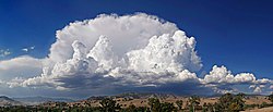
The trigger for the lift of the initial cumulus cloud can be insolation heating the ground producing thermals, areas where two winds converge forcing air upwards, or where winds blow over terrain of increasing elevation. The moisture rapidly cools into liquid drops of water due to the cooler temperatures at high altitude, which appears as cumulus clouds. As the water vapor condenses into liquid, latent heat is released which warms the air, causing it to become less dense than the surrounding dry air. The air tends to rise in an updraft through the process of convection (hence the term convective precipitation). This creates a low-pressure zone beneath the forming thunderstorm, otherwise known as a cumulonimbus cloud. In a typical thunderstorm, approximately 5×10⁸ kg of water vapor is lifted into the Earth's atmosphere. [3] As they form in areas of minimal vertical wind shear, [4] the thunderstorm's rainfall creates a moist and relatively cool outflow boundary which undercuts the storm's low level inflow, and quickly causes dissipation. Waterspouts, small hail, and strong wind gusts can occur in association with these thunderstorms. [5]

Common locations of appearance

Also known as single cell thunderstorms, these are the typical summer thunderstorms in many temperate locales. They also occur in the cool unstable air which often follows the passage of a cold front from the sea during winter. Within a cluster of thunderstorms, the term "cell" refers to each separate principal updraft. Thunderstorm cells occasionally form in isolation, as the occurrence of one thunderstorm can develop an outflow boundary which sets up new thunderstorm development. Such storms are rarely severe and are a result of local atmospheric instability; hence the term "air mass thunderstorm". When such storms have a brief period of severe weather associated with them, it is known as a pulse severe storm. Pulse severe storms are poorly organized due to the minimal vertical wind shear in the storm's environment and occur randomly in time and space, making them difficult to forecast. Between formation and dissipation, single cell thunderstorms normally last 20–30 minutes. [6]

Motion

Anvil shaped thundercloud in the mature stage over Swifts Creek, Victoria Anvil shaped cumulus panorama edit crop.jpg
Anvil shaped thundercloud in the mature stage over Swifts Creek, Victoria

The two major ways thunderstorms move are via advection of the wind and propagation along outflow boundaries towards sources of greater heat and moisture. Many thunderstorms move with the mean wind speed through the Earth's troposphere, or the lowest 8 kilometres (5.0 mi) of the Earth's atmosphere. Younger thunderstorms are steered by winds closer to the Earth's surface than more mature thunderstorms as they tend not to be as tall. If the gust front, or leading edge of the outflow boundary, moves ahead of the thunderstorm, the thunderstorm's motion will move in tandem with the gust front. This is more of a factor with thunderstorms with heavy precipitation (HP), such as air-mass thunderstorms. When thunderstorms merge, which is most likely when numerous thunderstorms exist in proximity to each other, the motion of the stronger thunderstorm normally dictates future motion of the merged cell. The stronger the mean wind, the less likely other processes will be involved in storm motion. On weather radar, storms are tracked by using a prominent feature and tracking it from scan to scan. [7]

Convective precipitation

Calvus type cumulonimbus cloud Wagga-Cumulonimbus.jpg
Calvus type cumulonimbus cloud

Convective rain, or showery precipitation, occurs from cumulonimbus clouds. It falls as showers with rapidly changing intensity. Convective precipitation falls over a certain area for a relatively short time, as convective clouds such as thunderstorms have limited horizontal extent. Most precipitation in the tropics appears to be convective. [8] [9] Graupel and hail are good indicators of convective precipitation and thunderstorms. [10] In mid-latitudes, convective precipitation is intermittent and often associated with baroclinic boundaries such as cold fronts, squall lines, and warm fronts. [11] High rainfall rates are associated with thunderstorms with larger raindrops. Heavy rainfall leads to fading of microwave transmissions starting above the frequency of 10 gigahertz (GHz), but is more severe above frequencies of 15 GHz. [12]

Lightning

Downward motion of cooler air from thunderstorms spreads outward in all directions when the environmental wind flow is light Microburstnasa.JPG
Downward motion of cooler air from thunderstorms spreads outward in all directions when the environmental wind flow is light

Relationships between lightning frequency and the height of precipitation within thunderstorms have been found. Thunderstorms which show radar returns above 14 kilometres (8.7 mi) in height are associated with storms which have more than ten lightning flashes per minute. There is also a correlation between the total lightning rate and the size of the thunderstorm, its updraft velocity, and amount of graupel over land. The same relationships fail over tropical oceans, however. [13] Lightning from low precipitation (LP) thunderstorms is one of the leading causes of wildfires. [14] [15]

Aviation concerns

In areas where these thunderstorms form in isolation and horizontal visibility is good, pilots can evade these storms rather easily. In more moist atmospheres which become hazy, pilots navigate above the haze layer in order to get a better vantage point of these storms. Flying under the anvil of thunderstorms is not advised, as hail is more likely to fall in such areas outside the thunderstorm's main rain shaft. [16] When an outflow boundary forms due to a shallow layer of rain-cooled air spreading out near ground level from the parent thunderstorm, both speed and directional wind shear can result at the leading edge of the three-dimensional boundary. The stronger the outflow boundary is, the stronger the resultant vertical wind shear will become. [17]

See also

Related Research Articles

<span class="mw-page-title-main">Hail</span> Form of solid precipitation

Hail is a form of solid precipitation. It is distinct from ice pellets, though the two are often confused. It consists of balls or irregular lumps of ice, each of which is called a hailstone. Ice pellets generally fall in cold weather, while hail growth is greatly inhibited during low surface temperatures.

<span class="mw-page-title-main">Cumulonimbus cloud</span> Genus of dense, towering vertical clouds

Cumulonimbus is a dense, towering vertical cloud, typically forming from water vapor condensing in the lower troposphere that builds upward carried by powerful buoyant air currents. Above the lower portions of the cumulonimbus the water vapor becomes ice crystals, such as snow and graupel, the interaction of which can lead to hail and to lightning formation, respectively. When occurring as a thunderstorm these clouds may be referred to as thunderheads. Cumulonimbus can form alone, in clusters, or along squall lines. These clouds are capable of producing lightning and other dangerous severe weather, such as tornadoes, hazardous winds, and large hailstones. Cumulonimbus progress from overdeveloped cumulus congestus clouds and may further develop as part of a supercell. Cumulonimbus is abbreviated Cb.

<span class="mw-page-title-main">Thunderstorm</span> Type of weather with lightning and thunder

A thunderstorm, also known as an electrical storm or a lightning storm, is a storm characterized by the presence of lightning and its acoustic effect on the Earth's atmosphere, known as thunder. Relatively weak thunderstorms are sometimes called thundershowers. Thunderstorms occur in a type of cloud known as a cumulonimbus. They are usually accompanied by strong winds and often produce heavy rain and sometimes snow, sleet, or hail, but some thunderstorms produce little precipitation or no precipitation at all. Thunderstorms may line up in a series or become a rainband, known as a squall line. Strong or severe thunderstorms include some of the most dangerous weather phenomena, including large hail, strong winds, and tornadoes. Some of the most persistent severe thunderstorms, known as supercells, rotate as do cyclones. While most thunderstorms move with the mean wind flow through the layer of the troposphere that they occupy, vertical wind shear sometimes causes a deviation in their course at a right angle to the wind shear direction.

<span class="mw-page-title-main">Supercell</span> Thunderstorm that is characterized by the presence of a mesocyclone

A supercell is a thunderstorm characterized by the presence of a mesocyclone, a deep, persistently rotating updraft. Due to this, these storms are sometimes referred to as rotating thunderstorms. Of the four classifications of thunderstorms, supercells are the overall least common and have the potential to be the most severe. Supercells are often isolated from other thunderstorms, and can dominate the local weather up to 32 kilometres (20 mi) away. They tend to last 2–4 hours.

<span class="mw-page-title-main">Mesocyclone</span> Region of rotation within a powerful thunderstorm

A mesocyclone is a meso-gamma mesoscale region of rotation (vortex), typically around 2 to 6 mi in diameter, most often noticed on radar within thunderstorms. In the northern hemisphere it is usually located in the right rear flank of a supercell, or often on the eastern, or leading, flank of a high-precipitation variety of supercell. The area overlaid by a mesocyclone’s circulation may be several miles (km) wide, but substantially larger than any tornado that may develop within it, and it is within mesocyclones that intense tornadoes form.

<span class="mw-page-title-main">Squall</span> Short, sharp increase in wind speed

A squall is a sudden, sharp increase in wind speed lasting minutes, as opposed to a wind gust, which lasts for only seconds. They are usually associated with active weather, such as rain showers, thunderstorms, or heavy snow. Squalls refer to the increase of the sustained winds over that time interval, as there may be higher gusts during a squall event. They usually occur in a region of strong sinking air or cooling in the mid-atmosphere. These force strong localized upward motions at the leading edge of the region of cooling, which then enhances local downward motions just in its wake.

<span class="mw-page-title-main">Precipitation</span> Product of the condensation of atmospheric water vapor that falls under gravity

In meteorology, precipitation is any product of the condensation of atmospheric water vapor that falls from clouds due to gravitational pull. The main forms of precipitation include drizzle, rain, sleet, snow, ice pellets, graupel and hail. Precipitation occurs when a portion of the atmosphere becomes saturated with water vapor, so that the water condenses and "precipitates" or falls. Thus, fog and mist are not precipitation but colloids, because the water vapor does not condense sufficiently to precipitate. Two processes, possibly acting together, can lead to air becoming saturated: cooling the air or adding water vapor to the air. Precipitation forms as smaller droplets coalesce via collision with other rain drops or ice crystals within a cloud. Short, intense periods of rain in scattered locations are called showers.

<span class="mw-page-title-main">Squall line</span> Line of thunderstorms along or ahead of a cold front

A squall line, or more accurately a quasi-linear convective system (QLCS), is a line of thunderstorms, often forming along or ahead of a cold front. In the early 20th century, the term was used as a synonym for cold front. Linear thunderstorm structures often contain heavy precipitation, hail, frequent lightning, strong straight-line winds, and occasionally tornadoes or waterspouts. Particularly strong straight-line winds can occur where the linear structure forms into the shape of a bow echo. Tornadoes can occur along waves within a line echo wave pattern (LEWP), where mesoscale low-pressure areas are present. Some bow echoes can grow to become derechos as they move swiftly across a large area. On the back edge of the rainband associated with mature squall lines, a wake low can be present, on very rare occasions associated with a heat burst.

<span class="mw-page-title-main">Outflow boundary</span> Mesoscale boundary separating outflow from the surrounding air

An outflow boundary, also known as a gust front, is a storm-scale or mesoscale boundary separating thunderstorm-cooled air (outflow) from the surrounding air; similar in effect to a cold front, with passage marked by a wind shift and usually a drop in temperature and a related pressure jump. Outflow boundaries can persist for 24 hours or more after the thunderstorms that generated them dissipate, and can travel hundreds of kilometers from their area of origin. New thunderstorms often develop along outflow boundaries, especially near the point of intersection with another boundary. Outflow boundaries can be seen either as fine lines on weather radar imagery or else as arcs of low clouds on weather satellite imagery. From the ground, outflow boundaries can be co-located with the appearance of roll clouds and shelf clouds.

This is a list of meteorology topics. The terms relate to meteorology, the interdisciplinary scientific study of the atmosphere that focuses on weather processes and forecasting.

<span class="mw-page-title-main">Weather front</span> Boundary separating two masses of air of different densities

A weather front is a boundary separating air masses for which several characteristics differ, such as air density, wind, temperature, and humidity. Disturbed and unstable weather due to these differences often arises along the boundary. For instance, cold fronts can bring bands of thunderstorms and cumulonimbus precipitation or be preceded by squall lines, while warm fronts are usually preceded by stratiform precipitation and fog. In summer, subtler humidity gradients known as dry lines can trigger severe weather. Some fronts produce no precipitation and little cloudiness, although there is invariably a wind shift.

<span class="mw-page-title-main">Mesoscale convective complex</span>

A mesoscale convective complex (MCC) is a unique kind of mesoscale convective system which is defined by characteristics observed in infrared satellite imagery. They are long-lived, often form nocturnally, and commonly contain heavy rainfall, wind, hail, lightning, and possibly tornadoes.

A pulse storm is a single cell thunderstorm of substantial intensity which only produces severe weather for short periods of time. Such a storm weakens and then generates another short burst – hence "pulse".

<span class="mw-page-title-main">Multicellular thunderstorm</span> Thunderstorm composed of multiple storm cells

A multicellular thunderstorm cluster is a thunderstorm that is composed of multiple convective cells, each being at a different stage in the life cycle of a thunderstorm. It appears as several anvils clustered together. A cell is an updraft/downdraft couplet. These different cells will dissipate as new cells form and continue the life of the multicellular thunderstorm cluster with each cell taking a turn as the dominant cell in the group.

<span class="mw-page-title-main">Atmospheric convection</span> Atmospheric phenomenon

Atmospheric convection is the result of a parcel-environment instability in the atmosphere. Different lapse rates within dry and moist air masses lead to instability. Mixing of air during the day expands the height of the planetary boundary layer, leading to increased winds, cumulus cloud development, and decreased surface dew points. Convection involving moist air masses leads to thunderstorm development, which is often responsible for severe weather throughout the world. Special threats from thunderstorms include hail, downbursts, and tornadoes.

Convective storm detection is the meteorological observation, and short-term prediction, of deep moist convection (DMC). DMC describes atmospheric conditions producing single or clusters of large vertical extension clouds ranging from cumulus congestus to cumulonimbus, the latter producing thunderstorms associated with lightning and thunder. Those two types of clouds can produce severe weather at the surface and aloft.

<span class="mw-page-title-main">Storm cell</span> Air mass with up and down drafts in consecutive loops as a single entity

A storm cell is an air mass that contains up and down drafts in convective loops and that moves and reacts as a single entity, functioning as the smallest unit of a storm-producing system. An organized grouping of thunder clouds will thus be considered as a series of storm cells with their up/downdrafts being independent or interfering one with the other.

<span class="mw-page-title-main">Atmospheric instability</span> Condition where the Earths atmosphere is generally considered to be unstable

Atmospheric instability is a condition where the Earth's atmosphere is considered to be unstable and as a result local weather is highly variable through distance and time. Atmospheric stability is a measure of the atmosphere's tendency to discourage vertical motion, and vertical motion is directly correlated to different types of weather systems and their severity. In unstable conditions, a lifted thing, such as a parcel of air will be warmer than the surrounding air. Because it is warmer, it is less dense and is prone to further ascent.

The following is a glossary of tornado terms. It includes scientific as well as selected informal terminology.

<span class="mw-page-title-main">Glossary of meteorology</span> List of definitions of terms and concepts commonly used in meteorology

This glossary of meteorology is a list of terms and concepts relevant to meteorology and atmospheric science, their sub-disciplines, and related fields.

References

  1. Robert M. Rauber; John E. Walsh; Donna J. Charlevoix (2008). "Chapter Eighteen: Thunderstorms". Severe & Hazardous Weather: An Introduction to High Impact Meteorology (3rd ed.). Dubuque, Iowa: Kendall/Hunt Publishing Company. pp. 333–335. ISBN   978-0-7575-5043-0.
  2. Jeff Haby (2008-02-19). "What Is An Air Mass Thunderstorm?". weatherprediction.com. Retrieved 3 December 2009.
  3. Gianfranco Vidali (2009). "Rough Values of Various Processes". Syracuse University. Archived from the original on 2010-03-15. Retrieved 2009-08-31.
  4. Steven Businger (2006-11-17). "Lecture 25 Air Mass Thunderstorms and Lightning" (PDF). University of Hawaiʻi . Retrieved 2010-06-08.
  5. Lee M. Grenci; Jon M. Nese (2001). A world of weather: fundamentals of meteorology: a text/ laboratory manual. Kendall Hunt. p. 213. ISBN   978-0-7872-7716-1.
  6. National Severe Storms Laboratory (2006-10-15). "A Severe Weather Primer: Questions and Answers about THUNDERSTORMS". National Oceanic and Atmospheric Administration. Archived from the original on 25 August 2009. Retrieved 2009-09-01.
  7. Jon W. Zeitler; Matthew J. Bunkers (March 2005). "Operational Forecasting of Supercell Motion: Review and Case Studies Using Multiple Datasets" (PDF). National Weather Service Forecast Office, Riverton, Wyoming . Retrieved 2009-08-30.
  8. B. Geerts (2002). "Convective and stratiform rainfall in the tropics". University of Wyoming. Archived from the original on 19 December 2007. Retrieved 2007-11-27.
  9. Robert Houze (October 1997). "Stratiform Precipitation in Regions of Convection: A Meteorological Paradox?". Bulletin of the American Meteorological Society. 78 (10): 2179–2196. Bibcode:1997BAMS...78.2179H. doi: 10.1175/1520-0477(1997)078<2179:SPIROC>2.0.CO;2 .
  10. Glossary of Meteorology (2009). "Graupel". American Meteorological Society. Archived from the original on 2008-03-08. Retrieved 2009-01-02.
  11. Toby N. Carlson (1991). Mid-latitude Weather Systems. Routledge. p. 216. ISBN   978-0-04-551115-0.
  12. Harvey Lehpamer (2010). Microwave transmission networks: planning, design, and deployment. McGraw Hill Professional. p. 107. ISBN   978-0-07-170122-8.
  13. Vladimir A. Rakov; Martin A. Uman (2007). Lightning: Physics and Effects. Cambridge University Press. pp. 30–31. ISBN   978-0-521-03541-5.
  14. "Wildfire Prevention Strategies" (PDF). National Wildfire Coordinating Group. March 1998. p. 17. Archived from the original (PDF) on 2008-12-09. Retrieved 2008-12-03.
  15. Vladimir A. Rakov (1999). "Lightning Makes Glass". University of Florida, Gainesville. Archived from the original on 11 November 2007. Retrieved November 7, 2007.
  16. Robert N. Buck (1997). Weather Flying. McGraw-Hill Professional. p. 190. ISBN   978-0-07-008761-3.
  17. T. T. Fujita (1985). "The Downburst, microburst and macroburst". SMRP Research Paper 210, 122 pages.