Outflow boundary

Last updated
Outflow boundary on radar with radial velocity and frontal boundary drawn in. Outflow bndry.png
Outflow boundary on radar with radial velocity and frontal boundary drawn in.

An outflow boundary, also known as a gust front, is a storm-scale or mesoscale boundary separating thunderstorm-cooled air (outflow) from the surrounding air; similar in effect to a cold front, with passage marked by a wind shift and usually a drop in temperature and a related pressure jump. Outflow boundaries can persist for 24 hours or more after the thunderstorms that generated them dissipate, and can travel hundreds of kilometers from their area of origin. New thunderstorms often develop along outflow boundaries, especially near the point of intersection with another boundary (cold front, dry line, another outflow boundary, etc.). Outflow boundaries can be seen either as fine lines on weather radar imagery or else as arcs of low clouds on weather satellite imagery. From the ground, outflow boundaries can be co-located with the appearance of roll clouds and shelf clouds. [1]

Contents

Outflow boundaries create low-level wind shear which can be hazardous during aircraft takeoffs and landings. If a thunderstorm runs into an outflow boundary, the low-level wind shear from the boundary can cause thunderstorms to exhibit rotation at the base of the storm, at times causing tornadic activity. Strong versions of these features known as downbursts can be generated in environments of vertical wind shear and mid-level dry air. Microbursts have a diameter of influence less than 4 kilometres (2.5 mi), while macrobursts occur over a diameter greater than 4 kilometres (2.5 mi). Wet microbursts occur in atmospheres where the low levels are saturated, while dry microbursts occur in drier atmospheres from high-based thunderstorms. When an outflow boundary moves into a more stable low level environment, such as into a region of cooler air or over regions of cooler water temperatures out at sea, it can lead to the development of an undular bore. [2]

Definition

Thunderstorm with lead gust front near Brookhaven, New Mexico, United States, North America. The gust front is marked by a shelf cloud. Thunderstorm with lead gust front - NOAA.jpg
Thunderstorm with lead gust front near Brookhaven, New Mexico, United States, North America. The gust front is marked by a shelf cloud.

An outflow boundary, also known as a gust front or arc cloud, is the leading edge of gusty, cooler surface winds from thunderstorm downdrafts; sometimes associated with a shelf cloud or roll cloud. A pressure jump is associated with its passage. [3] Outflow boundaries can persist for over 24 hours and travel hundreds of kilometers (miles) from their area of origin. [1] A wrapping gust front is a front that wraps around the mesocyclone, cutting off the inflow of warm moist air and resulting in occlusion. This is sometimes the case during the event of a collapsing storm, in which the wind literally "rips it apart". [4]

Origin

Illustration of a microburst. The wind regime in a microburst is opposite to that of a tornado. Microburstnasa.JPG
Illustration of a microburst. The wind regime in a microburst is opposite to that of a tornado.

A microburst is a very localized column of sinking air known as a downburst, producing damaging divergent and straight-line winds at the surface that are similar to but distinguishable from tornadoes which generally have convergent damage. [2] The term was defined as affecting an area 4 kilometres (2.5 mi) in diameter or less, [5] distinguishing them as a type of downburst and apart from common wind shear which can encompass greater areas. They are normally associated with individual thunderstorms. Microburst soundings show the presence of mid-level dry air, which enhances evaporative cooling. [6]

Organized areas of thunderstorm activity reinforce pre-existing frontal zones, and can outrun cold fronts. This outrunning occurs within the westerlies in a pattern where the upper-level jet splits into two streams. The resultant mesoscale convective system (MCS) forms at the point of the upper level split in the wind pattern in the area of best low level inflow. The convection then moves east and toward the equator into the warm sector, parallel to low-level thickness lines. When the convection is strong and linear or curved, the MCS is called a squall line, with the feature placed at the leading edge of the significant wind shift and pressure rise which is normally just ahead of its radar signature. [7] This feature is commonly depicted in the warm season across the United States on surface analyses, as they lie within sharp surface troughs.

A macroburst, normally associated with squall lines, is a strong downburst larger than 4 kilometres (2.5 mi). [8] A wet microburst consists of precipitation and an atmosphere saturated in the low-levels. A dry microburst emanates from high-based thunderstorms with virga falling from their base. [6] All types are formed by precipitation-cooled air rushing to the surface. Downbursts can occur over large areas. In the extreme case, a derecho can cover a huge area more than 200 miles (320 km) wide and over 1,000 miles (1,600 km) long, lasting up to 12 hours or more, and is associated with some of the most intense straight-line winds, but the generative process is somewhat different from that of most downbursts. [9]

Appearance

This shelf cloud preceded a derecho in Minnesota DangerousShelfCloud.jpg
This shelf cloud preceded a derecho in Minnesota

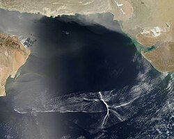
At ground level, shelf clouds and roll clouds can be seen at the leading edge of outflow boundaries. [10] Through satellite imagery, an arc cloud is visible as an arc of low clouds spreading out from a thunderstorm. If the skies are cloudy behind the arc, or if the arc is moving quickly, high wind gusts are likely behind the gust front. [11] Sometimes a gust front can be seen on weather radar, showing as a thin arc or line of weak radar echos pushing out from a collapsing storm. The thin line of weak radar echoes is known as a fine line. [12] Occasionally, winds caused by the gust front are so high in velocity that they also show up on radar. This cool outdraft can then energize other storms which it hits by assisting in updrafts. Gust fronts colliding from two storms can even create new storms. Usually, however, no rain accompanies the shifting winds. An expansion of the rain shaft near ground level, in the general shape of a human foot, is a telltale sign of a downburst. Gustnadoes, short-lived vertical circulations near ground level, can be spawned by outflow boundaries. [6]

Effects

Satellite image of an undular bore Ondes de pression au-dessus de la Mer d'Arabie.jpg
Satellite image of an undular bore

Gust fronts create low-level wind shear which can be hazardous to planes when they takeoff or land. [13] Flying insects are swept along by the prevailing winds. [14] As such, fine line patterns within weather radar imagery, associated with converging winds, are dominated by insect returns. [15] At the surface, clouds of dust can be raised by outflow boundaries. If squall lines form over arid regions, a duststorm known as a haboob can result from the high winds picking up dust in their wake from the desert floor. [16] If outflow boundaries move into areas of the atmosphere which are stable in the low levels, such through the cold sector of extratropical cyclones or a nocturnal boundary layer, they can create a phenomenon known as an undular bore, which shows up on satellite and radar imagery as a series of transverse waves in the cloud field oriented perpendicular to the low-level winds. [17]

See also

Related Research Articles

<span class="mw-page-title-main">Cumulonimbus cloud</span> Genus of dense, towering vertical clouds

Cumulonimbus is a dense, towering vertical cloud, typically forming from water vapor condensing in the lower troposphere that builds upward carried by powerful buoyant air currents. Above the lower portions of the cumulonimbus the water vapor becomes ice crystals, such as snow and graupel, the interaction of which can lead to hail and to lightning formation, respectively. When occurring as a thunderstorm these clouds may be referred to as thunderheads. Cumulonimbus can form alone, in clusters, or along squall lines. These clouds are capable of producing lightning and other dangerous severe weather, such as tornadoes, hazardous winds, and large hailstones. Cumulonimbus progress from overdeveloped cumulus congestus clouds and may further develop as part of a supercell. Cumulonimbus is abbreviated Cb.

<span class="mw-page-title-main">Thunderstorm</span> Type of weather with lightning and thunder

A thunderstorm, also known as an electrical storm or a lightning storm, is a storm characterized by the presence of lightning and its acoustic effect on the Earth's atmosphere, known as thunder. Relatively weak thunderstorms are sometimes called thundershowers. Thunderstorms occur in a type of cloud known as a cumulonimbus. They are usually accompanied by strong winds and often produce heavy rain and sometimes snow, sleet, or hail, but some thunderstorms produce little precipitation or no precipitation at all. Thunderstorms may line up in a series or become a rainband, known as a squall line. Strong or severe thunderstorms include some of the most dangerous weather phenomena, including large hail, strong winds, and tornadoes. Some of the most persistent severe thunderstorms, known as supercells, rotate as do cyclones. While most thunderstorms move with the mean wind flow through the layer of the troposphere that they occupy, vertical wind shear sometimes causes a deviation in their course at a right angle to the wind shear direction.

<span class="mw-page-title-main">Surface weather analysis</span> Type of weather map

Surface weather analysis is a special type of weather map that provides a view of weather elements over a geographical area at a specified time based on information from ground-based weather stations.

<span class="mw-page-title-main">Wind shear</span> Difference in wind speed or direction over a short distance

Wind shear, sometimes referred to as wind gradient, is a difference in wind speed and/or direction over a relatively short distance in the atmosphere. Atmospheric wind shear is normally described as either vertical or horizontal wind shear. Vertical wind shear is a change in wind speed or direction with a change in altitude. Horizontal wind shear is a change in wind speed with a change in lateral position for a given altitude.

<span class="mw-page-title-main">Mesocyclone</span> Region of rotation within a powerful thunderstorm

A mesocyclone is a meso-gamma mesoscale region of rotation (vortex), typically around 2 to 6 mi in diameter, most often noticed on radar within thunderstorms. In the northern hemisphere it is usually located in the right rear flank of a supercell, or often on the eastern, or leading, flank of a high-precipitation variety of supercell. The area overlaid by a mesocyclone’s circulation may be several miles (km) wide, but substantially larger than any tornado that may develop within it, and it is within mesocyclones that intense tornadoes form.

<span class="mw-page-title-main">Squall</span> Short, sharp increase in wind speed

A squall is a sudden, sharp increase in wind speed lasting minutes, as opposed to a wind gust, which lasts for only seconds. They are usually associated with active weather, such as rain showers, thunderstorms, or heavy snow. Squalls refer to the increase of the sustained winds over that time interval, as there may be higher gusts during a squall event. They usually occur in a region of strong sinking air or cooling in the mid-atmosphere. These force strong localized upward motions at the leading edge of the region of cooling, which then enhances local downward motions just in its wake.

<span class="mw-page-title-main">Squall line</span> Line of thunderstorms along or ahead of a cold front

A squall line, or more accurately a quasi-linear convective system (QLCS), is a line of thunderstorms, often forming along or ahead of a cold front. In the early 20th century, the term was used as a synonym for cold front. Linear thunderstorm structures often contain heavy precipitation, hail, frequent lightning, strong straight-line winds, and occasionally tornadoes or waterspouts. Particularly strong straight-line winds can occur where the linear structure forms into the shape of a bow echo. Tornadoes can occur along waves within a line echo wave pattern (LEWP), where mesoscale low-pressure areas are present. Some bow echoes can grow to become derechos as they move swiftly across a large area. On the back edge of the rainband associated with mature squall lines, a wake low can be present, on very rare occasions associated with a heat burst.

<span class="mw-page-title-main">Downburst</span> Strong surface-level winds that radiate from a single point

In meteorology, a downburst is a strong downward and outward gushing wind system that emanates from a point source above and blows radially, that is, in straight lines in all directions from the area of impact at surface level. Capable of producing damaging winds, it may sometimes be confused with a tornado, where high-velocity winds circle a central area, and air moves inward and upward. These usually last for seconds to minutes. Downbursts are particularly strong downdrafts within thunderstorms.

<span class="mw-page-title-main">Derecho</span> Widespread, long-lived, straight-line wind storm

A derecho is a widespread, long-lived, straight-line wind storm that is associated with a fast-moving group of severe thunderstorms known as a mesoscale convective system.

<span class="mw-page-title-main">Gustnado</span> Ground vortex formed from a downburst of a thunderstorm

A gustnado is a brief, shallow surface-based vortex which forms within the downburst emanating from a thunderstorm. The name is a portmanteau by elision of "gust front tornado", as gustnadoes form due to non-tornadic straight-line wind features in the downdraft (outflow), specifically within the gust front of strong thunderstorms. Gustnadoes tend to be noticed when the vortices loft sufficient debris or form condensation cloud to be visible although it is the wind that makes the gustnado, similarly to tornadoes. As these eddies very rarely connect from the surface to the cloud base, they are very rarely considered as tornadoes. The gustnado has little in common with tornadoes structurally or dynamically in regard to vertical development, intensity, longevity, or formative process—as classic tornadoes are associated with mesocyclones within the inflow (updraft) of the storm, not the outflow.

<span class="mw-page-title-main">Vertical draft</span> Small-scale current of rising air

In meteorology, an updraft is a small-scale current of rising air, often within a cloud.

<span class="mw-page-title-main">Arcus cloud</span> Low-altitude horizontal cloud formation

An arcus cloud is a low, horizontal cloud formation, usually appearing as an accessory cloud to a cumulonimbus. Roll clouds and shelf clouds are the two main types of arcus clouds. They most frequently form along the leading edge or gust fronts of thunderstorms; some of the most dramatic arcus formations mark the gust fronts of derecho-producing convective systems. Roll clouds may also arise in the absence of thunderstorms, forming along the shallow cold air currents of some sea breeze boundaries and cold fronts.

A pulse storm is a single cell thunderstorm of substantial intensity which only produces severe weather for short periods of time. Such a storm weakens and then generates another short burst – hence "pulse".

<span class="mw-page-title-main">Air-mass thunderstorm</span> Thunderstorm that is generally weak and usually not severe

An air-mass thunderstorm, also called an "ordinary", "single cell", "isolated" or "garden variety" thunderstorm, is a thunderstorm that is generally weak and usually not severe. These storms form in environments where at least some amount of Convective Available Potential Energy (CAPE) is present, but with very low levels of wind shear and helicity. The lifting source, which is a crucial factor in thunderstorm development, is usually the result of uneven heating of the surface, though they can be induced by weather fronts and other low-level boundaries associated with wind convergence. The energy needed for these storms to form comes in the form of insolation, or solar radiation. Air-mass thunderstorms do not move quickly, last no longer than an hour, and have the threats of lightning, as well as showery light, moderate, or heavy rainfall. Heavy rainfall can interfere with microwave transmissions within the atmosphere.

<span class="mw-page-title-main">Outflow (meteorology)</span> Air that flows outwards from a storm system

Outflow, in meteorology, is air that flows outwards from a storm system. It is associated with ridging, or anticyclonic flow. In the low levels of the troposphere, outflow radiates from thunderstorms in the form of a wedge of rain-cooled air, which is visible as a thin rope-like cloud on weather satellite imagery or a fine line on weather radar imagery. For observers on the ground, a thunderstorm outflow boundary often approaches in otherwise clear skies as a low, thick cloud that brings with it a gust front.

<span class="mw-page-title-main">Atmospheric convection</span> Atmospheric phenomenon

Atmospheric convection is the result of a parcel-environment instability in the atmosphere. Different lapse rates within dry and moist air masses lead to instability. Mixing of air during the day expands the height of the planetary boundary layer, leading to increased winds, cumulus cloud development, and decreased surface dew points. Convection involving moist air masses leads to thunderstorm development, which is often responsible for severe weather throughout the world. Special threats from thunderstorms include hail, downbursts, and tornadoes.

Convective storm detection is the meteorological observation, and short-term prediction, of deep moist convection (DMC). DMC describes atmospheric conditions producing single or clusters of large vertical extension clouds ranging from cumulus congestus to cumulonimbus, the latter producing thunderstorms associated with lightning and thunder. Those two types of clouds can produce severe weather at the surface and aloft.

A mesovortex is a small-scale rotational feature found in a convective storm, such as a quasi-linear convective system, a supercell, or the eyewall of a tropical cyclone. Mesovortices range in diameter from tens of miles to a mile or less and can be immensely intense.

The following is a glossary of tornado terms. It includes scientific as well as selected informal terminology.

<span class="mw-page-title-main">Glossary of meteorology</span> List of definitions of terms and concepts commonly used in meteorology

This glossary of meteorology is a list of terms and concepts relevant to meteorology and atmospheric science, their sub-disciplines, and related fields.

References

  1. 1 2 National Weather Service (2004-11-01). "Outflow Boundary" . Retrieved 2008-07-09.
  2. 1 2 Nolan Atkins (2009). "How to distinguish between tornado and microburst (straight-line) wind damage". Lyndon State College Meteorology. Retrieved 2008-07-09.
  3. Glossary of Meteorology (2009). "Gust Front". American Meteorological Society. Archived from the original on 2011-05-05. Retrieved 2009-07-03.
  4. National Weather Service (2004-11-01). "Wrapping Gust Front" . Retrieved 2009-07-03.
  5. National Weather Association (2003-11-23). "Welcome to Lesson 5". Archived from the original on 2009-01-06. Retrieved 2008-07-09.
  6. 1 2 3 Fernando Caracena; Ronald L. Holle & Charles A. Doswell III (2002-06-26). "Microbursts: A Handbook for Visual Identification". Cooperative Institute for Mesoscale Meteorological Studies. Retrieved 2008-07-09.
  7. National Oceanic and Atmospheric Administration   Office of the Federal Coordinator for Meteorological Services and Supporting Research (May 2001). "National Severe Local Storms Operations Plan  FCM-P11-2001  Chapter 2: Definitions" (PDF). Washington, D.C.: United States Department of Commerce. pp. 2–1. Archived from the original (PDF) on 2009-05-06. Retrieved 2019-07-01.{{cite web}}: CS1 maint: multiple names: authors list (link) CS1 maint: numeric names: authors list (link)
  8. Ali Tokay (2000-04-21). "Chapter #13: Thunderstorms". University of Maryland Baltimore College. Archived from the original on 2008-06-14. Retrieved 2008-07-09.
  9. Peter S. Parke & Norvan J. Larson (2005-11-23). "Boundary Waters Windstorm". Duluth, Minnesota: National Weather Service Forecast Office. Retrieved 2008-07-30.
  10. National Oceanic and Atmospheric Administration   Office of the Federal Coordinator for Meteorological Services and Supporting Research (December 2005). "Federal Meteorological Handbook No. 11  FCM-H11B-2005 Doppler RADAR Meteorological Observations Part B Doppler RADAR Theory and Meteorology" (PDF). Washington, D.C.: United States Department of Commerce . Retrieved 2019-07-01.{{cite web}}: CS1 maint: multiple names: authors list (link) CS1 maint: numeric names: authors list (link)
  11. Pravas Mahapatra; Richard Doviak; Vladislav Mazur; Dušan S. Zrnić (1999). Aviation weather surveillance systems: advanced radar and surface sensors for flight safety and air traffic management, Volume 183. Institution of Electrical Engineers. p. 322. ISBN   978-0-85296-937-3 . Retrieved 2009-09-01.
  12. Glossary of Meteorology (2009). "Fine Line". American Meteorological Society. Archived from the original on 2011-06-06. Retrieved 2009-07-03.
  13. Diana L. Klingle; David R. Smith & Marilyn M. Wolfson (May 1987). "Gust Front Characteristics as Detected by Doppler Radar". Monthly Weather Review. 115 (5): 905–918. Bibcode:1987MWRv..115..905K. doi: 10.1175/1520-0493(1987)115<0905:GFCADB>2.0.CO;2 .
  14. Diana Yates (2008). "Birds migrate together at night in dispersed flocks, new study indicates". University of Illinois at Urbana–Champaign . Retrieved 2009-04-26.
  15. Bart Geerts & Dave Leon (2003). "P5A.6 Fine-Scale Vertical Structure of a Cold Front As Revealed By Airborne 95 GHz Radar" (PDF). University of Wyoming . Retrieved 2009-04-26.
  16. Western Region Climate Center (2002). "H". Desert Research Institute. Retrieved 2006-10-22.
  17. Martin Setvak; Jochen Kerkmann; Alexander Jacob; HansPeter Roesli; Stefano Gallino & Daniel Lindsey (2007-03-19). "Outflow from convective storm, Mauritania and adjacent Atlantic Ocean (13 August 2006)" (PDF). Agenzia Regionale per la Protezione dell'Ambiente Ligure. Archived from the original on 25 July 2011. Retrieved 2009-07-03.{{cite web}}: CS1 maint: bot: original URL status unknown (link)