A thunderstorm, also known as an electrical storm or a lightning storm, is a storm characterized by the presence of lightning and its acoustic effect on the Earth's atmosphere, known as thunder. Relatively weak thunderstorms are sometimes called thundershowers. Thunderstorms occur in a type of cloud known as a cumulonimbus. They are usually accompanied by strong winds and often produce heavy rain and sometimes snow, sleet, or hail, but some thunderstorms produce little precipitation or no precipitation at all. Thunderstorms may line up in a series or become a rainband, known as a squall line. Strong or severe thunderstorms include some of the most dangerous weather phenomena, including large hail, strong winds, and tornadoes. Some of the most persistent severe thunderstorms, known as supercells, rotate as do cyclones. While most thunderstorms move with the mean wind flow through the layer of the troposphere that they occupy, vertical wind shear sometimes causes a deviation in their course at a right angle to the wind shear direction.
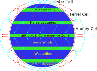
The horse latitudes are the latitudes about 30 degrees north and south of the Equator. They are characterized by sunny skies, calm winds, and very little precipitation. They are also known as subtropical ridges or highs. It is a high-pressure area at the divergence of trade winds and the westerlies.

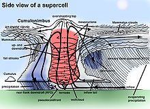
A mesocyclone is a meso-gamma mesoscale region of rotation (vortex), typically around 2 to 6 mi in diameter, most often noticed on radar within thunderstorms. In the northern hemisphere it is usually located in the right rear flank of a supercell, or often on the eastern, or leading, flank of a high-precipitation variety of supercell. The area overlaid by a mesocyclone’s circulation may be several miles (km) wide, but substantially larger than any tornado that may develop within it, and it is within mesocyclones that intense tornadoes form.

A squall is a sudden, sharp increase in wind speed lasting minutes, as opposed to a wind gust, which lasts for only seconds. They are usually associated with active weather, such as rain showers, thunderstorms, or heavy snow. Squalls refer to the increase of the sustained winds over that time interval, as there may be higher gusts during a squall event. They usually occur in a region of strong sinking air or cooling in the mid-atmosphere. These force strong localized upward motions at the leading edge of the region of cooling, which then enhances local downward motions just in its wake.

In meteorology, an air mass is a volume of air defined by its temperature and humidity. Air masses cover many hundreds or thousands of square miles, and adapt to the characteristics of the surface below them. They are classified according to latitude and their continental or maritime source regions. Colder air masses are termed polar or arctic, while warmer air masses are deemed tropical. Continental and superior air masses are dry, while maritime and monsoon air masses are moist. Weather fronts separate air masses with different density characteristics. Once an air mass moves away from its source region, underlying vegetation and water bodies can quickly modify its character. Classification schemes tackle an air mass's characteristics, as well as modification.

A squall line, or more accurately a quasi-linear convective system (QLCS), is a line of thunderstorms, often forming along or ahead of a cold front. In the early 20th century, the term was used as a synonym for cold front. Linear thunderstorm structures often contain heavy precipitation, hail, frequent lightning, strong straight-line winds, and occasionally tornadoes or waterspouts. Particularly strong straight-line winds can occur where the linear structure forms into the shape of a bow echo. Tornadoes can occur along waves within a line echo wave pattern (LEWP), where mesoscale low-pressure areas are present. Some bow echoes can grow to become derechos as they move swiftly across a large area. On the back edge of the rainband associated with mature squall lines, a wake low can be present, on very rare occasions associated with a heat burst.

In meteorology, a low-pressure area, low area or low is a region where the atmospheric pressure is lower than that of surrounding locations. Low-pressure areas are commonly associated with inclement weather, while high-pressure areas are associated with lighter winds and clear skies. Winds circle anti-clockwise around lows in the northern hemisphere, and clockwise in the southern hemisphere, due to opposing Coriolis forces. Low-pressure systems form under areas of wind divergence that occur in the upper levels of the atmosphere (aloft). The formation process of a low-pressure area is known as cyclogenesis. In meteorology, atmospheric divergence aloft occurs in two kinds of places:

A wall cloud is a large, localized, persistent, and often abrupt lowering of cloud that develops beneath the surrounding base of a cumulonimbus cloud and from which tornadoes sometimes form. It is typically beneath the rain-free base (RFB) portion of a thunderstorm, and indicates the area of the strongest updraft within a storm. Rotating wall clouds are an indication of a mesocyclone in a thunderstorm; most strong tornadoes form from these. Many wall clouds do rotate; however, some do not.

Cyclogenesis is the development or strengthening of cyclonic circulation in the atmosphere. Cyclogenesis is an umbrella term for at least three different processes, all of which result in the development of some sort of cyclone, and at any size from the microscale to the synoptic scale.

A weather front is a boundary separating air masses for which several characteristics differ, such as air density, wind, temperature, and humidity. Disturbed and unstable weather due to these differences often arises along the boundary. For instance, cold fronts can bring bands of thunderstorms and cumulonimbus precipitation or be preceded by squall lines, while warm fronts are usually preceded by stratiform precipitation and fog. In summer, subtler humidity gradients known as dry lines can trigger severe weather. Some fronts produce no precipitation and little cloudiness, although there is invariably a wind shift.

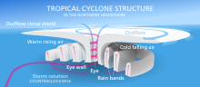
A rainband is a cloud and precipitation structure associated with an area of rainfall which is significantly elongated. Rainbands can be stratiform or convective, and are generated by differences in temperature. When noted on weather radar imagery, this precipitation elongation is referred to as banded structure. Rainbands within tropical cyclones are curved in orientation. Rainbands of tropical cyclones contain showers and thunderstorms that, together with the eyewall and the eye, constitute a hurricane or tropical storm. The extent of rainbands around a tropical cyclone can help determine the cyclone's intensity.

A mesoscale convective system (MCS) is a complex of thunderstorms that becomes organized on a scale larger than the individual thunderstorms but smaller than extratropical cyclones, and normally persists for several hours or more. A mesoscale convective system's overall cloud and precipitation pattern may be round or linear in shape, and include weather systems such as tropical cyclones, squall lines, lake-effect snow events, polar lows, and mesoscale convective complexes (MCCs), and generally forms near weather fronts. The type that forms during the warm season over land has been noted across North and South America, Europe, and Asia, with a maximum in activity noted during the late afternoon and evening hours.

Extratropical cyclones, sometimes called mid-latitude cyclones or wave cyclones, are low-pressure areas which, along with the anticyclones of high-pressure areas, drive the weather over much of the Earth. Extratropical cyclones are capable of producing anything from cloudiness and mild showers to severe gales, thunderstorms, blizzards, and tornadoes. These types of cyclones are defined as large scale (synoptic) low pressure weather systems that occur in the middle latitudes of the Earth. In contrast with tropical cyclones, extratropical cyclones produce rapid changes in temperature and dew point along broad lines, called weather fronts, about the center of the cyclone.
The older of the models of extratropical cyclone development is known as the Norwegian cyclone model, developed during and shortly after World War I within the Bergen School of Meteorology. In this theory, cyclones develop as they move up and along a frontal boundary, eventually occluding and reaching a barotropically cold environment. It was developed completely from surface-based weather observations, including descriptions of clouds found near frontal boundaries. Developed from this model was the concept of the warm conveyor belt, which transports warm and moist air just ahead of the cold front above the surface warm front.
Outflow, in meteorology, is air that flows outwards from a storm system. It is associated with ridging, or anticyclonic flow. In the low levels of the troposphere, outflow radiates from thunderstorms in the form of a wedge of rain-cooled air, which is visible as a thin rope-like cloud on weather satellite imagery or a fine line on weather radar imagery. For observers on the ground, a thunderstorm outflow boundary often approaches in otherwise clear skies as a low, thick cloud that brings with it a gust front.
Convective storm detection is the meteorological observation, and short-term prediction, of deep moist convection (DMC). DMC describes atmospheric conditions producing single or clusters of large vertical extension clouds ranging from cumulus congestus to cumulonimbus, the latter producing thunderstorms associated with lightning and thunder. Those two types of clouds can produce severe weather at the surface and aloft.

A cold front is the leading edge of a cooler mass of air at ground level that replaces a warmer mass of air and lies within a pronounced surface trough of low pressure. It often forms behind an extratropical cyclone, at the leading edge of its cold air advection pattern—known as the cyclone's dry "conveyor belt" flow. Temperature differences across the boundary can exceed 30 °C (54 °F) from one side to the other. When enough moisture is present, rain can occur along the boundary. If there is significant instability along the boundary, a narrow line of thunderstorms can form along the frontal zone. If instability is weak, a broad shield of rain can move in behind the front, and evaporative cooling of the rain can increase the temperature difference across the front. Cold fronts are stronger in the fall and spring transition seasons and are weakest during the summer.
The following is a glossary of tornado terms. It includes scientific as well as selected informal terminology.

This glossary of meteorology is a list of terms and concepts relevant to meteorology and atmospheric science, their sub-disciplines, and related fields.