Atmospheric physics

Last updated

Within the atmospheric sciences, atmospheric physics is the application of physics to the study of the atmosphere. Atmospheric physicists attempt to model Earth's atmosphere and the atmospheres of the other planets using fluid flow equations, radiation budget, and energy transfer processes in the atmosphere (as well as how these tie into boundary systems such as the oceans). In order to model weather systems, atmospheric physicists employ elements of scattering theory, wave propagation models, cloud physics, statistical mechanics and spatial statistics which are highly mathematical and related to physics. It has close links to meteorology and climatology and also covers the design and construction of instruments for studying the atmosphere and the interpretation of the data they provide, including remote sensing instruments. At the dawn of the space age and the introduction of sounding rockets, aeronomy became a subdiscipline concerning the upper layers of the atmosphere, where dissociation and ionization are important.

Contents

Remote sensing

Brightness can indicate reflectivity as in this 1960 weather radar image (of Hurricane Abby). The radar's frequency, pulse form, and antenna largely determine what it can observe. Weather radar.jpg
Brightness can indicate reflectivity as in this 1960 weather radar image (of Hurricane Abby). The radar's frequency, pulse form, and antenna largely determine what it can observe.

Remote sensing is the small or large-scale acquisition of information of an object or phenomenon, by the use of either recording or real-time sensing device(s) that is not in physical or intimate contact with the object (such as by way of aircraft, spacecraft, satellite, buoy, or ship). In practice, remote sensing is the stand-off collection through the use of a variety of devices for gathering information on a given object or area which gives more information than sensors at individual sites might convey. [1] Thus, Earth observation or weather satellite collection platforms, ocean and atmospheric observing weather buoy platforms, monitoring of a pregnancy via ultrasound, magnetic resonance imaging (MRI), positron-emission tomography (PET), and space probes are all examples of remote sensing. In modern usage, the term generally refers to the use of imaging sensor technologies including but not limited to the use of instruments aboard aircraft and spacecraft, and is distinct from other imaging-related fields such as medical imaging.

There are two kinds of remote sensing. Passive sensors detect natural radiation that is emitted or reflected by the object or surrounding area being observed. Reflected sunlight is the most common source of radiation measured by passive sensors. Examples of passive remote sensors include film photography, infrared, charge-coupled devices, and radiometers. Active collection, on the other hand, emits energy in order to scan objects and areas whereupon a sensor then detects and measures the radiation that is reflected or backscattered from the target. radar, lidar, and SODAR are examples of active remote sensing techniques used in atmospheric physics where the time delay between emission and return is measured, establishing the location, height, speed and direction of an object. [2]

Remote sensing makes it possible to collect data on dangerous or inaccessible areas. Remote sensing applications include monitoring deforestation in areas such as the Amazon Basin, the effects of climate change on glaciers and Arctic and Antarctic regions, and depth sounding of coastal and ocean depths. Military collection during the Cold War made use of stand-off collection of data about dangerous border areas. Remote sensing also replaces costly and slow data collection on the ground, ensuring in the process that areas or objects are not disturbed.

Orbital platforms collect and transmit data from different parts of the electromagnetic spectrum, which in conjunction with larger scale aerial or ground-based sensing and analysis, provides researchers with enough information to monitor trends such as El Niño and other natural long and short term phenomena. Other uses include different areas of the earth sciences such as natural resource management, agricultural fields such as land usage and conservation, and national security and overhead, ground-based and stand-off collection on border areas. [3]

Radiation

This is a diagram of the seasons. In addition to the density of incident light, the dissipation of light in the atmosphere is greater when it falls at a shallow angle. Seasons.svg
This is a diagram of the seasons. In addition to the density of incident light, the dissipation of light in the atmosphere is greater when it falls at a shallow angle.

Atmospheric physicists typically divide radiation into solar radiation (emitted by the sun) and terrestrial radiation (emitted by Earth's surface and atmosphere).

Solar radiation contains variety of wavelengths. Visible light has wavelengths between 0.4 and 0.7 micrometers. [4] Shorter wavelengths are known as the ultraviolet (UV) part of the spectrum, while longer wavelengths are grouped into the infrared portion of the spectrum. [5] Ozone is most effective in absorbing radiation around 0.25 micrometers, [6] where UV-c rays lie in the spectrum. This increases the temperature of the nearby stratosphere. Snow reflects 88% of UV rays, [6] while sand reflects 12%, and water reflects only 4% of incoming UV radiation. [6] The more glancing the angle is between the atmosphere and the sun's rays, the more likely that energy will be reflected or absorbed by the atmosphere. [7]

Terrestrial radiation is emitted at much longer wavelengths than solar radiation. This is because Earth is much colder than the sun. Radiation is emitted by Earth across a range of wavelengths, as formalized in Planck's law. The wavelength of maximum energy is around 10 micrometers.

Cloud physics

Cloud physics is the study of the physical processes that lead to the formation, growth and precipitation of clouds. Clouds are composed of microscopic droplets of water (warm clouds), tiny crystals of ice, or both (mixed phase clouds). Under suitable conditions, the droplets combine to form precipitation, where they may fall to the earth. [8] The precise mechanics of how a cloud forms and grows is not completely understood, but scientists have developed theories explaining the structure of clouds by studying the microphysics of individual droplets. Advances in radar and satellite technology have also allowed the precise study of clouds on a large scale.

Atmospheric electricity

Cloud-to-ground lightning in the global atmospheric electrical circuit Lightning over Oradea Romania 3.jpg
Cloud-to-ground lightning in the global atmospheric electrical circuit

Atmospheric electricity is the term given to the electrostatics and electrodynamics of the atmosphere (or, more broadly, the atmosphere of any planet). The Earth's surface, the ionosphere, and the atmosphere is known as the global atmospheric electrical circuit. [9] Lightning discharges 30,000 amperes, at up to 100 million volts, and emits light, radio waves, X-rays and even gamma rays. [10] Plasma temperatures in lightning can approach 28,000 kelvins and electron densities may exceed 1024/m3. [11]

Atmospheric tide

The largest-amplitude atmospheric tides are mostly generated in the troposphere and stratosphere when the atmosphere is periodically heated as water vapour and ozone absorb solar radiation during the day. The tides generated are then able to propagate away from these source regions and ascend into the mesosphere and thermosphere. Atmospheric tides can be measured as regular fluctuations in wind, temperature, density and pressure. Although atmospheric tides share much in common with ocean tides they have two key distinguishing features:

i) Atmospheric tides are primarily excited by the Sun's heating of the atmosphere whereas ocean tides are primarily excited by the Moon's gravitational field. This means that most atmospheric tides have periods of oscillation related to the 24-hour length of the solar day whereas ocean tides have longer periods of oscillation related to the lunar day (time between successive lunar transits) of about 24 hours 51 minutes. [12]

ii) Atmospheric tides propagate in an atmosphere where density varies significantly with height. A consequence of this is that their amplitudes naturally increase exponentially as the tide ascends into progressively more rarefied regions of the atmosphere (for an explanation of this phenomenon, see below). In contrast, the density of the oceans varies only slightly with depth and so there the tides do not necessarily vary in amplitude with depth.

Note that although solar heating is responsible for the largest-amplitude atmospheric tides, the gravitational fields of the Sun and Moon also raise tides in the atmosphere, with the lunar gravitational atmospheric tidal effect being significantly greater than its solar counterpart. [13]

At ground level, atmospheric tides can be detected as regular but small oscillations in surface pressure with periods of 24 and 12 hours. Daily pressure maxima occur at 10 a.m. and 10 p.m. local time, while minima occur at 4 a.m. and 4 p.m. local time. The absolute maximum occurs at 10 a.m. while the absolute minimum occurs at 4 p.m. [14] However, at greater heights the amplitudes of the tides can become very large. In the mesosphere (heights of ~ 50 – 100 km) atmospheric tides can reach amplitudes of more than 50 m/s and are often the most significant part of the motion of the atmosphere.

Aeronomy

Representation of upper-atmospheric lightning and electrical-discharge phenomena Upperatmoslight1.jpg
Representation of upper-atmospheric lightning and electrical-discharge phenomena

Aeronomy is the science of the upper region of the atmosphere, where dissociation and ionization are important. The term aeronomy was introduced by Sydney Chapman in 1960. [15] Today, the term also includes the science of the corresponding regions of the atmospheres of other planets. Research in aeronomy requires access to balloons, satellites, and sounding rockets which provide valuable data about this region of the atmosphere. Atmospheric tides play an important role in interacting with both the lower and upper atmosphere. Amongst the phenomena studied are upper-atmospheric lightning discharges, such as luminous events called red sprites, sprite halos, blue jets, and elves.

Centers of research

In the UK, atmospheric studies are underpinned by the Met Office, the Natural Environment Research Council and the Science and Technology Facilities Council. Divisions of the U.S. National Oceanic and Atmospheric Administration (NOAA) oversee research projects and weather modeling involving atmospheric physics. The US National Astronomy and Ionosphere Center also carries out studies of the high atmosphere. In Belgium, the Belgian Institute for Space Aeronomy studies the atmosphere and outer space. In France, there are several public or private entities researching the atmosphere, as an example météo-France (Météo-France), several laboratories in the national scientific research center (such as the laboratories in the IPSL group).

See also

Related Research Articles

<span class="mw-page-title-main">Electromagnetic spectrum</span> Entire range of frequencies of electromagnetic radiation

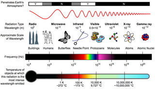
The electromagnetic spectrum is the range of frequencies of electromagnetic radiation and their respective wavelengths and photon energies.

<span class="mw-page-title-main">Greenhouse effect</span> Atmospheric phenomenon causing planetary warming

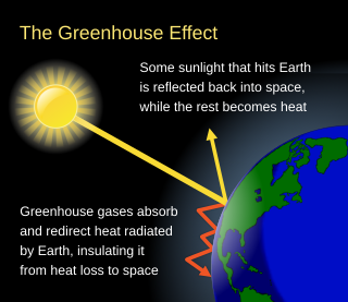
The greenhouse effect occurs when greenhouse gases in a planet's atmosphere cause some of the heat radiated from the planet's surface to build up at the planet's surface. This process happens because stars emit shortwave radiation that passes through greenhouse gases, but planets emit longwave radiation that is partly absorbed by greenhouse gases. That difference reduces the rate at which a planet can cool off in response to being warmed by its host star. Adding to greenhouse gases further reduces the rate a planet emits radiation to space, raising its average surface temperature.

<span class="mw-page-title-main">Infrared</span> Form of electromagnetic radiation

Infrared is electromagnetic radiation (EMR) with wavelengths longer than those of visible light and shorter than radio waves. It is therefore invisible to the human eye. IR is generally understood to encompass wavelengths from around 1 millimeter (300 GHz) to the nominal red edge of the visible spectrum, around 700 nanometers (430 THz). IR is commonly divided between longer-wavelength thermal infrared that is emitted from terrestrial sources and shorter-wavelength near-infrared that is part of the solar spectrum. Longer IR wavelengths (30–100 μm) are sometimes included as part of the terahertz radiation range. Almost all black-body radiation from objects near room temperature is at infrared wavelengths. As a form of electromagnetic radiation, IR propagates energy and momentum, exerts radiation pressure, and has properties corresponding to both those of a wave and of a particle, the photon.

<span class="mw-page-title-main">Sunlight</span> Light emitted by the Sun

Sunlight is a portion of the electromagnetic radiation given off by the Sun, in particular infrared, visible, and ultraviolet light. On Earth, sunlight is scattered and filtered through Earth's atmosphere, and is obvious as daylight when the Sun is above the horizon. When direct solar radiation is not blocked by clouds, it is experienced as sunshine, a combination of bright light and radiant heat. When blocked by clouds or reflected off other objects, sunlight is diffused. Sources estimate a global average of between 164 watts to 340 watts per square meter over a 24-hour day; this figure is estimated by NASA to be about a quarter of Earth's average total solar irradiance.

<span class="mw-page-title-main">Mesosphere</span> Layer of the atmosphere directly above the stratosphere and below the thermosphere

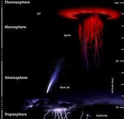
The mesosphere is the third layer of the atmosphere, directly above the stratosphere and directly below the thermosphere. In the mesosphere, temperature decreases as altitude increases. This characteristic is used to define limits: it begins at the top of the stratosphere, and ends at the mesopause, which is the coldest part of Earth's atmosphere, with temperatures below −143 °C. The exact upper and lower boundaries of the mesosphere vary with latitude and with season, but the lower boundary is usually located at altitudes from 47 to 51 km above sea level, and the upper boundary is usually from 85 to 100 km.

<span class="mw-page-title-main">Thermosphere</span> Layer of the Earths atmosphere above the mesosphere and below the exosphere

The thermosphere is the layer in the Earth's atmosphere directly above the mesosphere and below the exosphere. Within this layer of the atmosphere, ultraviolet radiation causes photoionization/photodissociation of molecules, creating ions; the thermosphere thus constitutes the larger part of the ionosphere. Taking its name from the Greek θερμός meaning heat, the thermosphere begins at about 80 km (50 mi) above sea level. At these high altitudes, the residual atmospheric gases sort into strata according to molecular mass. Thermospheric temperatures increase with altitude due to absorption of highly energetic solar radiation. Temperatures are highly dependent on solar activity, and can rise to 2,000 °C (3,630 °F) or more. Radiation causes the atmospheric particles in this layer to become electrically charged, enabling radio waves to be refracted and thus be received beyond the horizon. In the exosphere, beginning at about 600 km (375 mi) above sea level, the atmosphere turns into space, although, by the judging criteria set for the definition of the Kármán line (100 km), most of the thermosphere is part of space. The border between the thermosphere and exosphere is known as the thermopause.

<span class="mw-page-title-main">Atmospheric science</span> Study of the atmosphere, its processes, and its interactions with other systems

Atmospheric science is the study of the Earth's atmosphere and its various inner-working physical processes. Meteorology includes atmospheric chemistry and atmospheric physics with a major focus on weather forecasting. Climatology is the study of atmospheric changes that define average climates and their change over time, due to both natural and anthropogenic climate variability. Aeronomy is the study of the upper layers of the atmosphere, where dissociation and ionization are important. Atmospheric science has been extended to the field of planetary science and the study of the atmospheres of the planets and natural satellites of the Solar System.

<span class="mw-page-title-main">Thermal radiation</span> Electromagnetic radiation generated by the thermal motion of particles

Thermal radiation is electromagnetic radiation generated by the thermal motion of particles in matter. Thermal radiation is generated when heat from the movement of charges in the material is converted to electromagnetic radiation. All matter with a temperature greater than absolute zero emits thermal radiation. At room temperature, most of the emission is in the infrared (IR) spectrum. Particle motion results in charge-acceleration or dipole oscillation which produces electromagnetic radiation.

<span class="mw-page-title-main">Atmosphere of Earth</span> Gas layer surrounding Earth

The atmosphere of Earth is the layer of gases, known collectively as air, retained by Earth's gravity that surrounds the planet and forms its planetary atmosphere. The atmosphere of Earth creates pressure, absorbs most meteoroids and ultraviolet solar radiation, warms the surface through heat retention, allowing life and liquid water to exist on the Earth's surface, and reduces temperature extremes between day and night.

<span class="mw-page-title-main">Microwave radiometer</span>

A microwave radiometer (MWR) is a radiometer that measures energy emitted at one millimeter-to-metre wavelengths (frequencies of 0.3–300 GHz) known as microwaves. Microwave radiometers are very sensitive receivers designed to measure thermally-emitted electromagnetic radiation. They are usually equipped with multiple receiving channels to derive the characteristic emission spectrum of planetary atmospheres, surfaces or extraterrestrial objects. Microwave radiometers are utilized in a variety of environmental and engineering applications, including remote sensing, weather forecasting, climate monitoring, radio astronomy and radio propagation studies.

<span class="mw-page-title-main">Remote sensing</span> Acquisition of information at a significant distance from the subject

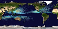
Remote sensing is the acquisition of information about an object or phenomenon without making physical contact with the object, in contrast to in situ or on-site observation. The term is applied especially to acquiring information about Earth and other planets. Remote sensing is used in numerous fields, including geophysics, geography, land surveying and most Earth science disciplines ; it also has military, intelligence, commercial, economic, planning, and humanitarian applications, among others.

<span class="mw-page-title-main">Clouds and the Earth's Radiant Energy System</span> NASA satellite climate data instruments

Clouds and the Earth's Radiant Energy System (CERES) is on-going NASA climatological experiment from Earth orbit. The CERES are scientific satellite instruments, part of the NASA's Earth Observing System (EOS), designed to measure both solar-reflected and Earth-emitted radiation from the top of the atmosphere (TOA) to the Earth's surface. Cloud properties are determined using simultaneous measurements by other EOS instruments such as the Moderate Resolution Imaging Spectroradiometer (MODIS). Results from the CERES and other NASA missions, such as the Earth Radiation Budget Experiment (ERBE), could enable nearer to real-time tracking of Earth's energy imbalance and better understanding of the role of clouds in global climate change.

<span class="mw-page-title-main">Emissivity</span> Capacity of an object to radiate electromagnetic energy

The emissivity of the surface of a material is its effectiveness in emitting energy as thermal radiation. Thermal radiation is electromagnetic radiation that most commonly includes both visible radiation (light) and infrared radiation, which is not visible to human eyes. A portion of the thermal radiation from very hot objects is easily visible to the eye.

<span class="mw-page-title-main">Aeronomy</span> Science of the upper region of the Earths or other planetary atmospheres

Aeronomy is the scientific study of the upper atmosphere of the Earth and corresponding regions of the atmospheres of other planets. It is a branch of both atmospheric chemistry and atmospheric physics. Scientists specializing in aeronomy, known as aeronomers, study the motions and chemical composition and properties of the Earth's upper atmosphere and regions of the atmospheres of other planets that correspond to it, as well as the interaction between upper atmospheres and the space environment. In atmospheric regions aeronomers study, chemical dissociation and ionization are important phenomena.

<span class="mw-page-title-main">Normalized difference vegetation index</span> Graphical indicator of remotely sensed live green vegetation

The normalized difference vegetation index (NDVI) is a widely-used metric for quantifying the health and density of vegetation using sensor data. It is calculated from spectrometric data at two specific bands: red and near-infrared. The spectrometric data is usually sourced from remote sensors, such as satellites.

<span class="mw-page-title-main">Advanced very-high-resolution radiometer</span>

The Advanced Very-High-Resolution Radiometer (AVHRR) instrument is a space-borne sensor that measures the reflectance of the Earth in five spectral bands that are relatively wide by today's standards. AVHRR instruments are or have been carried by the National Oceanic and Atmospheric Administration (NOAA) family of polar orbiting platforms (POES) and European MetOp satellites. The instrument scans several channels; two are centered on the red (0.6 micrometres) and near-infrared (0.9 micrometres) regions, a third one is located around 3.5 micrometres, and another two the thermal radiation emitted by the planet, around 11 and 12 micrometres.

<span class="mw-page-title-main">Outgoing longwave radiation</span> Energy transfer mechanism which enables planetary cooling

Longwave (LW) radiation, in the context of climate science, is electromagnetic thermal radiation emitted by Earth's surface, atmosphere, and clouds. Longwave radiation may also be referred to as terrestrial radiation, thermal infrared radiation, or thermal radiation. This radiation is in the infrared portion of the spectrum, but is distinct from the shortwave (SW) near-infrared radiation found in sunlight.

<span class="mw-page-title-main">Atmospheric window</span>

An atmospheric window is a range of wavelengths of the electromagnetic spectrum that can pass through the atmosphere of Earth. The optical, infrared and radio windows comprise the three main atmospheric windows. The windows provide direct channels for Earth's surface to receive electromagnetic energy from the Sun, and for thermal radiation from the surface to leave to space. Atmospheric windows are useful for astronomy, remote sensing, telecommunications and other science & technology applications.

<span class="mw-page-title-main">NOAA-9</span> American weather satellite

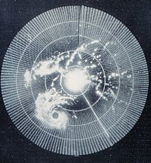
NOAA-9, known as NOAA-F before launch, was an American weather satellite operated by the National Oceanic and Atmospheric Administration (NOAA) for use in the National Environmental Satellite Data and Information Service (NESDIS). It was the second of the Advanced TIROS-N series of satellites. The satellite design provided an economical and stable Sun-synchronous platform for advanced operational instruments to measure the atmosphere of Earth, its surface and cloud cover, and the near-space environment.

NOAA-10, known as NOAA-G before launch, was an American weather satellite operated by the National Oceanic and Atmospheric Administration (NOAA) for use in the National Environmental Satellite Data and Information Service (NESDIS). It was the third of the Advanced TIROS-N series of satellites. The satellite design provided an economical and stable Sun-synchronous platform for advanced operational instruments to measure the atmosphere of Earth, its surface and cloud cover, and the near-space environment.

References

  1. COMET program (1999). Remote Sensing. Archived 2013-05-07 at the Wayback Machine University Corporation for Atmospheric Research. Retrieved on 2009-04-23.
  2. Glossary of Meteorology (2009). Radar. American Meteorological Society. Retrieved on 2009-24-23.
  3. NASA (2009). Earth. Archived 2006-09-29 at the Wayback Machine Retrieved on 2009-02-18.
  4. Atmospheric Science Data Center. What Wavelength Goes With a Color? Archived 2011-07-20 at the Wayback Machine Retrieved on 2008-04-15.
  5. Windows to the Universe. Solar Energy in Earth's Atmosphere. Archived 2010-01-31 at the Wayback Machine Retrieved on 2008-04-15.
  6. 1 2 3 University of Delaware. Geog 474: Energy Interactions with the Atmosphere and at the Surface. Retrieved on 2008-04-15.
  7. Wheeling Jesuit University. Exploring the Environment: UV Menace. Archived August 30, 2007, at the Wayback Machine Retrieved on 2007-06-01.
  8. Oklahoma Weather Modification Demonstration Program. CLOUD PHYSICS. Archived 2008-07-23 at the Wayback Machine Retrieved on 2008-04-15.
  9. Dr. Hugh J. Christian and Melanie A. McCook. Lightning Detection From Space: A Lightning Primer. Archived April 30, 2008, at the Wayback Machine Retrieved on 2008-04-17.
  10. NASA. Flashes in the Sky: Earth's Gamma-Ray Bursts Triggered by Lightning. Retrieved on 2007-06-01.
  11. Fusion Energy Education.Lightning! Sound and Fury. Archived 2016-11-23 at the Wayback Machine Retrieved on 2008-04-17.
  12. Glossary of Meteorology. Atmospheric Tide. Retrieved on 2008-04-15.
  13. Scientific American. Does the Moon have a tidal effect on the atmosphere as well as the oceans?. Retrieved on 2008-07-08.
  14. Dr James B. Calvert. Tidal Observations. Retrieved on 2008-04-15.
  15. Andrew F. Nagy, p. 1-2 in Comparative Aeronomy, ed. by Andrew F. Nagy et al. (Springer 2008, ISBN   978-0-387-87824-9)

Further reading