Castellanus

Last updated
Stratocumulus castellanus Cumulus castellanus 01.jpg
Stratocumulus castellanus

A castellanus (or castellatus) (from Latin castellanus, castle) is a cloud that displays at least in its upper part cumuliform protuberances having the shape of turrets that give a crenellated aspect. Some of these turrets are higher than they are wide; they have a common base and seem to be arranged in a line. [1] The castellanus characteristic is particularly obvious when the clouds are observed from the side (i.e., from a vantage point on a line perpendicular to the line of orientation).

Contents

It is a cloud species attached to the cloud genera cirrus, cirrocumulus, altocumulus and stratocumulus. [1] [2] [3] Species of the clouds include cirrus castellanus, cirrocumulus castellanus, altocumulus castellanus and stratocumulus castellanus. [1] Sometimes cumulus castellanus are referred to, but the type is not recognised by France's national meteorological service Météo-France, or by the American Meteorological Society and World Meteorological Organisation. [4] Those clouds some would classify as cumulus castellanus typically do not have a common base and are not arranged in a line, thus differing to some extent from the more universally-recognised castellanus types. Some scientists also think that the castellanus should be a full cloud genus, and not just a cloud species. The Federal Aviation Administration implicitly considers a castellanus as a full cloud genus. [5]

Physics

Figure 1: Single cell cumulonimbus that originating from a castellanus Cumulonimbus unicellulaire.jpg
Figure 1: Single cell cumulonimbus that originating from a castellanus

All castellanus clouds show that there exists an unstable (or conditionally unstable [6] ) layer at their altitude but not necessarily under the cloud. Some scientists (Scorer, [7] Corfidi [4] ) define a castellanus as a cloud generated by the release of latent heat during the ascension of a saturated thermal column in an unstable (or conditionally unstable) layer at altitude. [4] The cloud will have the appearance of a ''turkey tower''. [8] This unstable (or conditionally unstable) layer can be generated in different ways: (1) a large scale lifting (synoptic scale) that under some circumstances makes the air unstable since the temperature at the base of the layer decreases more slowly than the temperature at the top of cloud due to adiabatic decompression, (2) a cooling of the cloud top that generates the same differential, and (3) an unstable (or conditionally unstable) air mass advection over a stable air mass, etc.

Castellanus can arise from clouds formed by either surface-based convection (e.g., cumulus) or elevated convection (e.g., altocumulus). [4] Most of the convection in the towers, however, is due to instability (or conditional instability) at cloud height – not to convection below the cloud. The air surrounding the cloud is rapidly entrained into the towers. Cloud physics show that if a cloud does not contain enough humidity, [Note 1] the water vapour contained inside the cloud will only condense at a higher level, where the temperature of the ascending parcel reaches its saturation point. This will consequently dry out the cloud from the base and eventually result in its disappearance if this dry air does not condense below the cloud top. [4] [10] Conversely, if the air surrounding the cloud is nearly saturated and a thick, unstable (or conditionally unstable) layer exists above the initial cloud, convection will be able to continue. Then a tower, that will become wider and wider, will build up that will in some cases become a cumulonimbus.

The evolution of a castellanus thus depends on the amount of humidity and the characteristics of the unstable (or conditionally unstable) layer. Scattered clouds in the sky are generally found in relatively dry air with a more humid ''pocket''. If they show such a tall and narrow growth, the dry air surrounding them will not perpetuate the convection which will result in the cloud dissipation. However, a more extended cloud layer shows a higher relative humidity in the layer; a scenario more likely to be associated with over-development of the towers.

Nomenclature

The species castellanus is defined in the International Cloud Atlas, which had its last official release in 1975. [11] It is based on ground visual observation of cloud shape. In practice, the shape of a castellanus is related to the physical process producing it: local instability (or conditional instability) at the top of the cloud that breaks the temperature inversion and is the cause of the formation of towers, this being confirmed by vertical soundings.

However, although the species castellanus applies to different genera of convective clouds at different levels, the most current cloud type is the altocumulus castellanus, the base of which is in the medium level. This is reinforced by the fact that pilot's manuals interchangeably talk about either castellanus or altocumulus castellanus, restricting the meaning of the word catellanus. [5]

To alleviate this confusion, scientists Richard S. Scorer [7] and Corfidi [12] propose a cloud classification based only on physical criteria obtained from vertical soundings and observations from meteorological satellites to reclassify the castellanus as a cloud genus at the same level as a cumulus or a cirrus. Corfidi has long criticized the resistance from official bodies to this change. However, the 2016 version of the International Cloud Atlas will not change the status of the castellanus. [12] [13] The same scientists have a similar opinion about lenticular clouds that can exist at different levels that are not recognized as a full cloud genus but only as a species.

Criticism specifics

Figure 2: Convective clouds above a cloud layer generated by an expanding outflow of a downburst. View to the south. Altocumulus castellanus (Corfidi).jpg
Figure 2: Convective clouds above a cloud layer generated by an expanding outflow of a downburst. View to the south.

Scientists note a common confusion between convective clouds generated solely (or at least primarily) by diurnal heating of the ground and the castellanus, which is primarily a product of instability (or conditional instability) at the top of a cloud such as a cumulus, stratocumulus, or an altocumulus, the latter two genera being easily confused.

Moreover, the International Cloud Atlas (ICA) is not entirely precise regarding how to determine the genus of a convective cloud. Per the ICA (1975, p. 15–16), the base of a cumulus cloud is usually between the surface and 2 kilometres (6,600 ft). This height limit originates from observations in temperate climates where the surface temperature and humidity are about average. It does not take into account how the cloud is formed. In the American West, the base of cumulus clouds can reach 4,000 metres (13,000 ft), since the combination of a low dew point (10 °C (50 °F)) and high temperature (up to 45 °C (113 °F)) will yield a very high convective condensation level. [14] While the ICA allows that a cumulus cloud can have a base higher than 2 kilometres (6,600 ft) (by saying that cumulus clouds usually have their bases at or below this height), guidance given on page 16 of the ICA could lead to misclassification of a high cumulus cloud. This guidance says that a cloud's genus can be determined "by making a choice from among the genera normally encountered in the etage (height range) corresponding to its height." This could lead the observer to rule out cumulus as a possible genus for a cloud that has all the ICA-described characteristics of a cumulus except that its base is above the "Low" etage (surface to 2 kilometres (6,600 ft)). The observer, conscientiously trying to comply with ICA classification guidance, might then misidentify this cloud as an altocumulus (perhaps altocumulus floccus), although the instability creating it is at a different level compared to an altocumulus. [11]

To complicate matters even further, convective clouds of type castellanus can be generated by updrafts originating at intermediate altitudes with respect to the levels defined in the Atlas; it makes a continuum of possible altitudes. [12] These intermediate-altitude convective clouds will have flat bases except when generating precipitation. Moreover, the altitude of their bases can be higher than the level of condensation by convection or even higher than the level of free convection; it depends on the altitude where the forcing occurs. This phenomenon may occur when a cumulonimbus is in the vicinity. The latter will produce an outflow downstream of the cumulonimbus. The outflow boundary behaves like a pseudo cold front that generates a mechanical forcing where the outflow meets the surrounding air. The lifting enables the formation of convective towers at the level of the top of the outflow in preexisting clouds if the air is conditionally unstable.

An example of this phenomenon is shown in the adjacent figure and corresponds to Figure 2 of a paper written by Corfidi; [15] the thunderstorm is located to the east of the picture. The picture's caption in Corfidi's paper refers to the cloud as a castellanus [15] and not as a cumulus mediocris altocumulogenitus as the draft International Cloud Atlas would suggest. [16]

Soaring

Figure 3: Cumulus castellanus.Thes clouds can sometimes be used by glider pilots Cumulus castellanus 1.JPG
Figure 3: Cumulus castellanus.Thes clouds can sometimes be used by glider pilots

Castellanus (clouds made of very narrow columns) are notorious [17] as being unusable by glider pilots. In order for a cloud to have a usable thermal, the updraft column needs to exist under the cloud, in which case the cloud will have a flat base. An altocumulus castellanus, however, can be identified by the lack of a well-defined base. As said above, a hybrid cloud between cumulus and castellanus can be used by a glider pilot.

Castellanus that are unfavorable to soaring can be easily identified and are nicknamed ''rocket clouds.'' [18] The visual difference between a cumulus and a castellanus is that the former has a flat base while the latter generally has no clearly defined base. However, a visual observation of the cloud may not be sufficient, since in some cases the hybrid castellanus (pseudo cumulus) may have a flat base. The only sure way to distinguish between these two types of clouds is through an atmospheric sounding preceding the flight. If the base of these false cumulus is higher than the convective condensation level, the pilot is probably close to unwanted cumulonimbus. Moreover, when a cumulus breaks down, there may still exist an updraft column under the cloud base that did not originate from the ground. In particular, at the end of the day, the air-mass can be stable up to 2000 feet and unstable above this stable layer. The cumulus turn into stratocumulus or altocumulus depending on their height. Before the 1956 version of the International Cloud Atlas, these clouds were called stratocumulus or altocumulus "vesperalis". Directly under these clouds, updrafts are still present. The meteorologist Corfidi [19] explains that these seemingly innocuous clouds that break down rapidly can be a harbinger of nocturnal thunderstorms.

To identify non-ground-based convection, it is possible to compare the height of the base of the "cumulus" c with the convective condensation level h. This height h is given by the following formula: [20]

where a = 0.125 km / °C;

T is the surface temperature and D is the dew point. The variables c, T and D can be easily accessed from a neighbouring METAR.

The computation of this height h is based on first principles and therefore is rather accurate. Consequently, if , the observed cumulus are almost certainly castellanus under Corfidi's meaning. Then, it will be wise to be wary of the presence of a flanking line or of downbursts in the vicinity. Figure 2 shows such a pattern.

Notes and references

Notes

  1. The relative humidity inside a cloud is not strictly equal to 100%. It can in fact vary between 70% (on the side) and 107% (at the centre) inside convective clouds. [9]

Related Research Articles

<span class="mw-page-title-main">Cloud</span> Visible mass of liquid droplets or frozen crystals suspended in the atmosphere

In meteorology, a cloud is an aerosol consisting of a visible mass of miniature liquid droplets, frozen crystals, or other particles suspended in the atmosphere of a planetary body or similar space. Water or various other chemicals may compose the droplets and crystals. On Earth, clouds are formed as a result of saturation of the air when it is cooled to its dew point, or when it gains sufficient moisture from an adjacent source to raise the dew point to the ambient temperature.

<span class="mw-page-title-main">Cumulonimbus cloud</span> Genus of dense, towering vertical clouds

Cumulonimbus is a dense, towering vertical cloud, typically forming from water vapor condensing in the lower troposphere that builds upward carried by powerful buoyant air currents. Above the lower portions of the cumulonimbus the water vapor becomes ice crystals, such as snow and graupel, the interaction of which can lead to hail and to lightning formation, respectively. When occurring as a thunderstorm these clouds may be referred to as thunderheads. Cumulonimbus can form alone, in clusters, or along squall lines. These clouds are capable of producing lightning and other dangerous severe weather, such as tornadoes, hazardous winds, and large hailstones. Cumulonimbus progress from overdeveloped cumulus congestus clouds and may further develop as part of a supercell. Cumulonimbus is abbreviated Cb.

<span class="mw-page-title-main">Cumulus cloud</span> Genus of clouds, low-level cloud

Cumulus clouds are clouds that have flat bases and are often described as puffy, cotton-like, or fluffy in appearance. Their name derives from the Latin cumulus, meaning "heap" or "pile". Cumulus clouds are low-level clouds, generally less than 2,000 m (6,600 ft) in altitude unless they are the more vertical cumulus congestus form. Cumulus clouds may appear by themselves, in lines, or in clusters.

<span class="mw-page-title-main">Altocumulus cloud</span> Genus of mid-level cloud

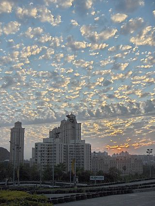
Altocumulus is a middle-altitude cloud genus that belongs mainly to the stratocumuliform physical category characterized by globular masses or rolls in layers or patches, the individual elements being larger and darker than those of cirrocumulus and smaller than those of stratocumulus. However, if the layers become tufted in appearance due to increased airmass instability, then the altocumulus clouds become more purely cumuliform in structure. Like other cumuliform and stratocumuliform clouds, altocumulus signifies convection. A sheet of partially conjoined altocumulus perlucidus is sometimes found preceding a weakening warm front, where the altostratus is starting to fragment, resulting in patches of altocumulus perlucidus between the areas of altostratus. Altocumulus is also commonly found between the warm and cold fronts in a depression, although this is often hidden by lower clouds.

<span class="mw-page-title-main">Stratocumulus cloud</span> Family class 3 cloud type

A stratocumulus cloud, occasionally called a cumulostratus, belongs to a genus-type of clouds characterized by large dark, rounded masses, usually in groups, lines, or waves, the individual elements being larger than those in altocumulus, and the whole being at a lower height, usually below 2,000 metres (6,600 ft). Weak convective currents create shallow cloud layers because of drier, stable air above preventing continued vertical development. Historically, in English, this type of cloud has been referred to as a twain cloud for being a combination of two types of clouds.

<span class="mw-page-title-main">Nimbostratus cloud</span> Common type of rain cloud

A nimbostratus cloud is a multilevel, amorphous, nearly uniform, and often dark-grey cloud that usually produces continuous rain, snow, or sleet, but no lightning or thunder.

<span class="mw-page-title-main">Stratus cloud</span> Type of cloud

Stratus clouds are low-level clouds characterized by horizontal layering with a uniform base, as opposed to convective or cumuliform clouds formed by rising thermals. The term stratus describes flat, hazy, featureless clouds at low altitudes varying in color from dark gray to nearly white. The word stratus comes from the Latin prefix strato-, meaning "layer". Stratus clouds may produce a light drizzle or a small amount of snow. These clouds are essentially above-ground fog formed either through the lifting of morning fog or through cold air moving at low altitudes. Some call these clouds "high fog" for their fog-like form.

<span class="mw-page-title-main">Warm front</span> Boundary of advancing mass of warm air

A warm front is a density discontinuity located at the leading edge of a homogeneous warm air mass, and is typically located on the equator-facing edge of an isotherm gradient. Warm fronts lie within broader troughs of low pressure than cold fronts, and move more slowly than the cold fronts which usually follow because cold air is denser and less easy to remove from the Earth's surface. This also forces temperature differences across warm fronts to be broader in scale. Clouds ahead of the warm front are mostly stratiform, and rainfall generally increases as the front approaches. Fog can also occur preceding a warm frontal passage. Clearing and warming is usually rapid after frontal passage. If the warm air mass is unstable, thunderstorms may be embedded among the stratiform clouds ahead of the front, and after frontal passage thundershowers may continue. On weather maps, the surface location of a warm front is marked with a red line of semicircles pointing in the direction of travel.

<span class="mw-page-title-main">Cloud physics</span> Study of the physical processes in atmospheric clouds

Cloud physics is the study of the physical processes that lead to the formation, growth and precipitation of atmospheric clouds. These aerosols are found in the troposphere, stratosphere, and mesosphere, which collectively make up the greatest part of the homosphere. Clouds consist of microscopic droplets of liquid water, tiny crystals of ice, or both, along with microscopic particles of dust, smoke, or other matter, known as condensation nuclei. Cloud droplets initially form by the condensation of water vapor onto condensation nuclei when the supersaturation of air exceeds a critical value according to Köhler theory. Cloud condensation nuclei are necessary for cloud droplets formation because of the Kelvin effect, which describes the change in saturation vapor pressure due to a curved surface. At small radii, the amount of supersaturation needed for condensation to occur is so large, that it does not happen naturally. Raoult's law describes how the vapor pressure is dependent on the amount of solute in a solution. At high concentrations, when the cloud droplets are small, the supersaturation required is smaller than without the presence of a nucleus.

<span class="mw-page-title-main">Convective available potential energy</span> Measure of instability in the air as a buoyancy force

In meteorology, convective available potential energy, is the integrated amount of work that the upward (positive) buoyancy force would perform on a given mass of air if it rose vertically through the entire atmosphere. Positive CAPE will cause the air parcel to rise, while negative CAPE will cause the air parcel to sink. Nonzero CAPE is an indicator of atmospheric instability in any given atmospheric sounding, a necessary condition for the development of cumulus and cumulonimbus clouds with attendant severe weather hazards.

<span class="mw-page-title-main">Altocumulus castellanus cloud</span>

In meteorology, Altocumulus castellanus or Altocumulus castellatus (ACCAS) is a cloud type named for its tower-like projections that billow upwards from the base of the cloud. The base of the cloud can form as low as 2,000 metres, or as high as 6,000 metres. They are very similar to cumulus congestus clouds, but at a higher level and with the cloud heaps joined at the base.

<span class="mw-page-title-main">Cumulus mediocris cloud</span>

Cumulus mediocris is a low to middle level cloud with some vertical extent of the genus cumulus, larger in vertical development than Cumulus humilis. It also may exhibit small protuberances from the top and may show the cauliflower form characteristic of cumulus clouds. Cumulus mediocris clouds do not generally produce precipitation of more than very light intensity, but can further advance into clouds such as Cumulus congestus or Cumulonimbus, which do produce precipitation and severe storms.

<span class="mw-page-title-main">Cumulus congestus cloud</span> Form of cumulus clouds

Cumulus congestus clouds, also known as towering cumulus, are a form of cumulus that can be based in the low or middle height ranges. They achieve considerable vertical development in areas of deep, moist convection. They are an intermediate stage between cumulus mediocris and cumulonimbus, sometimes producing showers of snow, rain, or ice pellets. Precipitation that evaporates before reaching the surface is virga.

<span class="mw-page-title-main">Free convective layer</span>

In atmospheric sciences, the free convective layer (FCL) is the layer of conditional or potential instability in the troposphere. It is a layer in which rising air can experience positive buoyancy (PBE) so that deep, moist convection (DMC) can occur. On an atmospheric sounding, it is the layer between the level of free convection (LFC) and the equilibrium level (EL). The FCL is important to a variety of convective processes and to severe thunderstorm forecasting.

<span class="mw-page-title-main">Atmospheric convection</span> Atmospheric phenomenon

Atmospheric convection is the result of a parcel-environment instability in the atmosphere. Different lapse rates within dry and moist air masses lead to instability. Mixing of air during the day expands the height of the planetary boundary layer, leading to increased winds, cumulus cloud development, and decreased surface dew points. Convection involving moist air masses leads to thunderstorm development, which is often responsible for severe weather throughout the world. Special threats from thunderstorms include hail, downbursts, and tornadoes.

Numerous accidents have occurred in the vicinity of thunderstorms due to the density of clouds. It is often said that the turbulence can be extreme enough inside a cumulonimbus to tear an aircraft into pieces, and even strong enough to hold a skydiver. However, this kind of accident is relatively rare. Moreover, the turbulence under a thunderstorm can be non-existent and is usually no more than moderate. Most thunderstorm-related crashes occur due to a stall close to the ground when the pilot gets caught by surprise by a thunderstorm-induced wind shift. Moreover, aircraft damage caused by thunderstorms is rarely in the form of structural failure due to turbulence but is typically less severe and the consequence of secondary effects of thunderstorms.

<span class="mw-page-title-main">Glossary of meteorology</span> List of definitions of terms and concepts commonly used in meteorology

This glossary of meteorology is a list of terms and concepts relevant to meteorology and atmospheric science, their sub-disciplines, and related fields.

<span class="mw-page-title-main">Shower (precipitation)</span> Sudden and brief rain or snowfall

A shower is a mode of precipitation characterized by an abrupt start and end and by rapid variations in intensity. Often strong and short-lived, it comes from convective clouds, like cumulus congestus. A shower will produce rain if the temperature is above the freezing point in the cloud, or snow / ice pellets / snow pellets / hail if the temperature is below it at some point. In a meteorological observation, such as the METAR, they are noted SH giving respectively SHRA, SHSN, SHPL, SHGS and SHGR.

<span class="mw-page-title-main">Stratocumulus castellanus cloud</span> Mid-level cloud that indicates unstable air

Stratocumulus castellanus or Stratocumulus castellatus is a type of stratocumulus cloud, castellanus is derived from Latin, meaning 'of a castle' This type of cloud appears as cumuliform turrets vertically rising from a common horizontal cloud base, these turrets are taller than they are wide

References

  1. 1 2 3 "Castellanus". Glossary. Eumetcal. Archived from the original on 5 February 2008. Retrieved 31 July 2016.
  2. "Espèces (nuage)". Comprendre la météorologie (in French). Météo-France. 2010. Archived from the original on 2019-12-08. Retrieved 2010-06-20.
  3. "Castellanus". Glossary of Meteorology. American Meteorological Society . Retrieved 2010-06-20.
  4. 1 2 3 4 5 Corfidi 2008
  5. 1 2 Pilot's Handbook of Aeronautical Knowledge (PDF), Federal Aviation Administration, 2016, pp. 12–17, archived from the original (PDF) on 2016-08-20, retrieved 2016-08-08
  6. "Conditional instability - AMS Glossary". glossary.ametsoc.org. American Meteorological Society . Retrieved 2016-08-16.
  7. 1 2 Richard S. Scorer (1972). Clouds of the world;a complete color encyclopedia. Stackpole books. 31–33. ISBN   978-0-8117-1961-2.
  8. Doswell, C. A., III, (2001). Severe convective storms—An overview. (Chap. 1 de Severe Convective Storms). American Meteorological Society, 1–26. Retrieved 2010-06-26.{{cite book}}: CS1 maint: multiple names: authors list (link) CS1 maint: numeric names: authors list (link)
  9. Pruppacher, Hans; Klett, James D (1997). Microphysics of clouds and precipitation. Atmospheric and oceanographic sciences library. Vol. 18. Kluwer. p. 10. ISBN   978-0-7923-4211-3.
  10. Malkus, Johann Starr; Scorer, Richard Segal (1955). "The erosion of cumulus towers". Journal of Meteorology . 12 (1): 43–57. Bibcode:1955JAtS...12...43S. doi: 10.1175/1520-0469(1955)012<0000:TEOCT>2.0.CO;2 .
  11. 1 2 Atlas I 1975 , p. 17
  12. 1 2 3 Corfidi 2008 , p. 1283
  13. "Draft text for the new edition of the International Cloud Atlas (available in English only)". World Meteorological Organisation . Retrieved 2016-07-09.
  14. Markowski, Paul; Richardson, Yvette (2010). Mesoscale Meteorology in Midlatitudes . John Wiley & Sons. p.  198. ISBN   978-0-470-74213-6.
  15. 1 2 Stefen F. Corfidi; et al. "Toward a better understanding of elevated convection" (PDF). NOAA . Retrieved 2011-07-27.
  16. "International Cloud Atlas (Draft)" (PDF). World Meteorological Organisation. 2016. p. 57. Retrieved 2016-08-02.
  17. Bradbury (2007). Meteorology and Flight: Pilot's Guide to Weather (Flying and Gliding) (3 ed.). London: A & C Black Publishers Limited. p. 64. ISBN   978-0-7136-6831-5.[ permanent dead link ]
  18. Tom Bradbury (1993). "Look for lift". p. 5.[ permanent dead link ]
  19. Corfidi 2008 , p. 1288
  20. Roland B. Stull (2000). Meteorology for Scientists and Engineers Second Edition. Brooks/Cole. p. 101. ISBN   978-0-534-37214-9.

See also

Bibliography