Related Research Articles

The Rhine–Main–Danube Canal, in Bavaria, Germany, connects the Main and the Danube rivers across the European Watershed, running from Bamberg via Nuremberg to Kelheim. The canal connects the North Sea and Atlantic Ocean to the Black Sea, providing a navigable artery between the Rhine delta, and the Danube Delta in south-eastern Romania and south-western Ukraine. The present canal was completed in 1992 and is 171 kilometres (106 mi) long.

The Celebes Sea of the western Pacific Ocean is bordered on the north by the Sulu Archipelago and Sulu Sea and Mindanao Island of the Philippines, on the east by the Sangihe Islands chain, on the south by Sulawesi's Minahasa Peninsula, and on the west by northern Kalimantan in Indonesia. It extends 420 miles (675 km) north-south by 520 mi (840 km) east-west and has a total surface area of 110,000 square miles (280,000 km2), to a maximum depth of 20,300 feet (6,200 m). South of the Mangkalihat Peninsula, the sea opens southwest through the Makassar Strait into the Java Sea.

Bihać is a city and the administrative center of Una-Sana Canton of the Federation of Bosnia and Herzegovina, an entity of Bosnia and Herzegovina. It is situated on the banks of river Una in northwestern Bosnia and Herzegovina, in the Bosanska Krajina region. As of 2013, it has a population of 56,261 inhabitants.
The district of Visp is a district in the Canton of Valais in southern Switzerland. It has a population of 28,454.
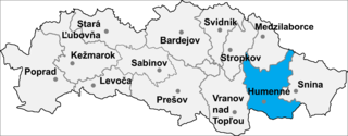
Sopkovce is a village and municipality in Humenné District in the Prešov Region of north-east Slovakia.

Trnovo is a village and municipality in Martin District in the Žilina Region of northern Slovakia.

Strullendorf is a community in the Upper Franconian district of Bamberg.

Zeegendorf is a small village located in Bavaria, Germany. It is in Oberfranken, in the Bamberg district. Zeegendorf is a constituent community of Strullendorf.
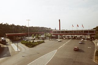
Checkpoint Bravo was the name given by the Western Allies to the main Autobahn border crossing point between West Berlin and the German Democratic Republic. It was known in German as Grenzübergangsstelle Drewitz-Dreilinden. Drewitz is a community nearby, and Dreilinden is the name of the wooded area in Berlin through which the highway passes.
Geisfeld is a small village located in Bavaria, Germany. It is in Upper Franconia, in the Bamberg district. Geisfeld is a constituent community of Strullendorf.

Amlingstadt is a small village located in Bavaria, Germany. It is in Upper Franconia, in the Bamberg district. Amlingstadt is a constituent community of Strullendorf.
Roßdorf am Forst is a small village located in Bavaria, Germany. It is in Upper Franconia, in the Bamberg district. Roßdorf am Forst is a constituent community of Strullendorf.
Mistendorf is a small village located in Bavaria, Germany. It is in Upper Franconia, in the Bamberg district. Mistendorf is a constituent community of Strullendorf.
The Zeegenbach is a stream in Franconia, Germany, in the Franconian Jura region, and is about 13 kilometres (8 mi) long. The Zeegenbach lies about 15 kilometres (9 mi) south-west from Bamberg by the town of Strullendorf.
Wernsdorf is a small village located in Bavaria, Germany. It is in Oberfranken, in the Bamberg district. Wernsdorf is a constituent community of Strullendorf and is located on the state roads 2188 and 2210, adjoining the neighbouring village of Amlingstadt. The population was recorded as 444 in 2009. There is a castle in the town, named the Schloss Wernsdorf.
Tiefenhöchstadt is a small village located in Bavaria, Germany. It is in Upper Franconia, in the Bamberg district. Tiefenhöchstadt is a constituent community of Buttenheim.

Erlach is a small village located in Bavaria, Germany. It is in Upper Franconia, in the Bamberg district. Erlach is a constituent community of Hirschaid.

Pasewalk (GS05) was a Kondor I-class minesweeper built in East Germany. After the Volksmarine was disbanded just before the reunification of Germany, she was sold to Malta in 1992 and renamed P31 and was used as a patrol boat. After being decommissioned, she was scuttled as a dive site in 2009 off Comino.
German submarine U-3523 was a Type XXI U-boat of Nazi Germany's Kriegsmarine, built for service in World War II. She was ordered on 6 November 1943, and was laid down on 7 October 1944 at F Schichau GmbH, Danzig, as yard number 1668. She was launched on 14 December 1944, and commissioned under the command of Oberleutnant zur See Willi Müller, on 23 January 1945.
References
- ↑ "Gemeinde Strullendorf - Demographie" Archived 2011-07-19 at the Wayback Machine , December 31, 2009. (in German)
- 1 2 "Google Maps - Search Result", Accessed September 20, 2010.