Related Research Articles

The Great Barrier Reef is the world's largest coral reef system, composed of over 2,900 individual reefs and 900 islands stretching for over 2,300 kilometres (1,400 mi) over an area of approximately 344,400 square kilometres (133,000 sq mi). The reef is located in the Coral Sea, off the coast of Queensland, Australia, separated from the coast by a channel 160 kilometres (100 mi) wide in places and over 61 metres (200 ft) deep. The Great Barrier Reef can be seen from outer space and is the world's biggest single structure made by living organisms. This reef structure is composed of and built by billions of tiny organisms, known as coral polyps. It supports a wide diversity of life and was selected as a World Heritage Site in 1981. CNN labelled it one of the Seven Natural Wonders of the World in 1997. Australian World Heritage places included it in its list in 2007. The Queensland National Trust named it a state icon of Queensland in 2006.

The Great Barrier Reef Marine Park protects a large part of Australia's Great Barrier Reef from damaging activities. It is a vast multiple-use Marine Park which supports a wide range of uses, including commercial marine tourism, fishing, ports and shipping, recreation, scientific research and Indigenous traditional use. Fishing and the removal of artefacts or wildlife is strictly regulated, and commercial shipping traffic must stick to certain specific defined shipping routes that avoid the most sensitive areas of the park. The Great Barrier Reef is the largest and best known coral reef ecosystem in the world. Its reefs, almost 3000 in total, represent about 10 per cent of all the coral reef areas in the world. It supports an amazing variety of biodiversity, providing a home to thousands of coral and other invertebrate species, bony fish, sharks, rays, marine mammals, marine turtles, sea snakes, as well as algae and other marine plants.

Capricornia Cays is both a national park and a scientific national park in Queensland (Australia), located 486 km and 472 km north of the state capital Brisbane respectively. Collectively they comprise 241 ha of coral cays.
Marpa is a national park at Yarraden on Cape York Peninsula in Far North Queensland, Australia, 1,757 km northwest of Brisbane. It is part of the Great Barrier Reef Marine Park west of Cape Melville in Princess Charlotte Bay. The park is a restricted access area in order to protect cultural resource of the islands traditional owners, the Lama Lama people.

Green Island National Park is a protected area declared over a small coral cay of Green Island, Cairns Region, Queensland, Australia. It is known to the local Gungganyji Aboriginal peoples as Dabuukji. The Gungganyji people used the island as an initiation ground.
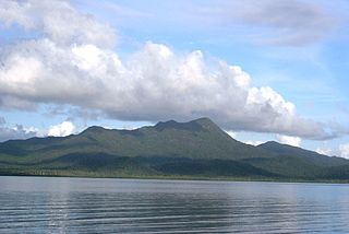
Hinchinbrook Island National Park is Australia's largest island national park. It is situated along the Cassowary Coast Queensland, Australia. The nearest capital city is Brisbane approximately 1,240 km to the south. Lucinda is 135 km or 1.5 hours drive north of Townsville being the closest North Queensland provincial city. Cairns a Far North Queensland provincial city is two and a half to 3 hours drive north from Cardwell. The main geographical features in the park are the rugged Hinchinbrook Island, including Mount Bowen, The Thumb, Mount Diamantina and Mount Straloch.

Lizard Island is an island on the Great Barrier Reef in Queensland (Australia), 1,624-kilometre (1,009 mi) northwest of Brisbane and part of the Lizard Island Group that also includes Palfrey Island. It is part of the Lizard Island National Park. Lizard Island is within the locality of Lizard in the Cook Shire.

The Coral Sea is a marginal sea of the South Pacific off the northeast coast of Australia, and classified as an interim Australian bioregion. The Coral Sea extends 2,000 kilometres (1,200 mi) down the Australian northeast coast. Most of it is protected by the French Natural Park of the Coral Sea and the Australian Coral Sea Marine Park. The sea was the location for the Battle of the Coral Sea, a major confrontation during World War II between the navies of the Empire of Japan, and the United States and Australia.

Buck Island Reef National Monument protects Buck Island, a small, uninhabited 176-acre island about 1.5 miles (2.4 km) north of the northeast coast of Saint Croix, U.S. Virgin Islands, and 18,839 acres of submerged lands, totaling 19,015 acres. It was first established as a protected area by the U.S. Government in 1948, with the intention of preserving “one of the finest marine gardens in the Caribbean Sea.” The U.S. National Monument was created in 1961 by John F. Kennedy and greatly expanded in 2001 by Bill Clinton, over the opposition of local fishermen. Buck Island National Monument is one of few places in the Virgin Islands where brown pelicans and threatened least terns nest.

Heron Island is a coral cay located near the Tropic of Capricorn in the southern Great Barrier Reef, 80 kilometres north-east of Gladstone, Queensland, Australia, and 460 km (290 mi) north-north-west of the state capital Brisbane. The island is situated on the leeward (western) side of Heron Reef, a fringing platform reef of significant biodiversity, supporting around 900 of the 1,500 fish species and 72% of the coral species found on the Great Barrier Reef. During the summer months Heron Island is also home to over 200,000 birds including Noddy Terns and Mutton Birds.
Lady Elliot Island is the southernmost coral cay of the Great Barrier Reef, Australia. The island lies 46 nautical miles north-east of Bundaberg and covers an area of approximately 45 hectares. It is part of the Capricorn and Bunker Group of islands and is owned by the Commonwealth of Australia. The island is home to a small eco resort and an airstrip, which is serviced daily by flights from Bundaberg, Hervey Bay, Brisbane and the Gold Coast.

The Mesoamerican Barrier Reef System (MBRS), also popularly known as the Great Mayan Reef or Great Maya Reef, is a marine region that stretches over 1,126 kilometres (700 mi) along the coasts of four countries – Mexico, Belize, Guatemala, and Honduras – from Isla Contoy at the northern tip of the Yucatán Peninsula south to Belize, Guatemala and the Bay Islands of Honduras. The reef system includes various protected areas and parks including the Belize Barrier Reef, Arrecifes de Cozumel National Park, Hol Chan Marine Reserve (Belize), Sian Ka'an biosphere reserve, and the Cayos Cochinos Marine Park. Belize's coastline, including the Belize Barrier Reef, is home to approximately 30% of the Mesoamerican Barrier Reef System.
There are two Morris Islands within 200 km of each other.
Sinclair Island is part of the Great Barrier Reef Marine Park and one of the southern island in the Cole Islands group and National Park and is about 100 km south-east of Cape Melville, Queensland.
Coquet Island is part of the Great Barrier Reef Marine Park and the easternmost island in the Cole Islands group and National Park and is about 100 km south-east of Cape Melville, Queensland.
Houghton Island is part of the Great Barrier Reef Marine Park and the easternmost island in the Cole Islands group and National Park. It is located approximately 100 km south-east of Cape Melville, Queensland and measures approximately 73 hectares, or 0.73 square km, in size.

Turtle Head Island is an island of the Torres Strait Islands archipelago, located in the Great Barrier Reef Marine Park, east of Cape York Peninsula, in Queensland, Australia.
Turtle Island is an island of the Torres Strait Islands archipelago, located in the Great Barrier Reef Marine Park, east of Cape York Peninsula, in Queensland, Australia.
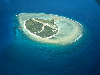
Raine Island is a vegetated coral cay 32 hectares in total area situated on the outer edges of the Great Barrier Reef off north-eastern Australia. It lies approximately 620 km (390 mi) north-northwest of Cairns in Queensland, about 120 kilometres (75 mi) east-north-east of Cape Grenville on the Cape York Peninsula.

Heron Island Research Station is a marine research station located on Heron Island, an island within the Great Barrier Reef Marine Park, 80 km from Gladstone, off the coast of Queensland, Australia. It is located at the leeward end of a coral cay on a 10 x 5 kilometre platform reef. Although the island had been used as a turtle cannery in the 1920s, after this was abandoned, it was taken over as a resort in the 1930s, by Captain Christian Poulsen. A number of researchers travelled to the island from the 1930s using the resort facilities. The island became a National Park in 1943, and following the end of World War II, saw the first groups of university students from the University of Queensland arrive. Today the island is divided into three sections - the resort, research station and National Park.
References
- ↑ "Torres Strait and Great Barrier Reef tide tables - Catalogue | National Library of Australia". catalogue.nla.gov.au. Retrieved 19 September 2023.
| | This Queensland protected areas related article is a stub. You can help Wikipedia by expanding it. |