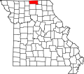
Lemons, Missouri

Last updated

Lemons is a census-designated place in southwestern Wilson Township, [1] Putnam County, Missouri, United States. [2] It is located approximately four miles south of Unionville on Route 5.

History

Lemons was originally spelled "Lemen Station", and under the latter name was platted in 1877 by Abraham Lemen, and named for him. [3] Other variant names were "Xenia", [3] "Leman Station", "Lemen", "Lemenville", "Lemons Station", and "Lemonville". [4] A post office called Lemen was established in 1876, the name was changed to Lemon Station in 1876, and closed in 1878. The post reopened as Xenia in 1879, renamed Lemonville in 1898, again was renamed Lemons in 1915, and the post office closed permanently in 1975. [5]

Related Research Articles

<span class="mw-page-title-main">Mount Forest Township, Michigan</span> Civil township in Michigan, United States

Mount Forest Township is a civil township of Bay County in the U.S. state of Michigan. The township's population was 1,392 as of the 2010 census. It is included in the Bay City Metropolitan Statistical Area.

<span class="mw-page-title-main">Volinia Township, Michigan</span> Civil township in Michigan, United States

Volinia Township is a civil township of Cass County in the U.S. state of Michigan. The population was 1,112 at the 2010 census. When the township was organized in 1833, it was at first named Volhynia, after the province in Poland. It is believed to have been given to honor General Tadeusz Kościuszko, the Polish patriot who helped the United States during the American Revolutionary War. The name was altered first to "Volenia" and then by 1901 or earlier to "Volinia".

<span class="mw-page-title-main">Hendricks Township, Michigan</span> Civil township in Michigan, United States

Hendricks Township is a civil township of Mackinac County in the U.S. state of Michigan. The population was 153 at the 2010 census.

<span class="mw-page-title-main">Rockland Township, Michigan</span> Civil township in Michigan, United States

Rockland Township is a civil township of Ontonagon County in the U.S. state of Michigan. The population was 226 at the 2020 census.

<span class="mw-page-title-main">Shields, Michigan</span> Census-designated place & unincorporated community in Michigan, United States

Shields is an unincorporated community in Thomas Township, Saginaw County in the U.S. state of Michigan. It is also a census-designated place (CDP) for statistical purposes, but with no legal status as an incorporated municipality. The population of the CDP was 7,035 at the 2020 census.

<span class="mw-page-title-main">Pittsford, Michigan</span> Census-designated place & unincorporated community in Michigan, United States

Pittsford is an unincorporated community and census-designated place (CDP) in Hillsdale County in the U.S. state of Michigan. The population of the CDP was 553 at the 2020 census. The community is located along M-34 on the border between Jefferson Township to the west and Pittsford Township to the east.

Xenia is an extinct community in Nodaway County, Missouri, in the United States. The exact location of Xenia is unknown to the GNIS.

Ravanna is a census-designated place in Mercer County, Missouri, United States. It is located approximately seven miles northeast of Princeton on U.S. Route 136. The population was 60 at the 2020 census.

<span class="mw-page-title-main">Chesapeake, Missouri</span> Census-Designated Place in Missouri, United States

Chesapeake is an unincorporated community and census-designated place in Lawrence County, Missouri, United States. It is located on Route 174, approximately five miles east of Mount Vernon.

Lemonville is a ghost town that was the site of the Lemon Lumber Company in northern Orange County, Texas, United States, in the southeastern part of the state. Sometimes referred to as Lemon, it is located north of Orange and just east of Mauriceville. The town plat was filed in 1901 by a man named William Manuel, with the location chosen for its proximity to the tracks of the Kansas City Southern Railroad. In 1902, when the population was about 300, a post office was established, with Cornelius P. Ryan as first postmaster.

<span class="mw-page-title-main">Montmorenci, Indiana</span> Census-designated place in Indiana, United States

Montmorenci is an unincorporated census-designated place in Shelby Township, Tippecanoe County, Indiana. Older maps sometimes spell the name Montmorency or Montmorencie.

<span class="mw-page-title-main">Beesley's Point, New Jersey</span> Populated place in Cape May County, New Jersey, US

Beesley's Point is an unincorporated community and census-designated place (CDP) in Upper Township, in Cape May County, in the U.S. state of New Jersey. Beesley's Point is on Peck Bay across from Ocean City. Beesley's Point is home to the Beesley's Point Generating Station and one end of the now-closed Beesley's Point Bridge.

Home Township is a civil township of Montcalm County in the U.S. state of Michigan. As of the 2000 census, the township population was 2,708.

Palermo is an unincorporated community and census-designated place (CDP) located in Upper Township, in Cape May County, in the U.S. state of New Jersey.

Quinn is an unincorporated community in Putnam County, in the U.S. state of Missouri.

St. John is an unincorporated community in Putnam County, in the U.S. state of Missouri.

Terre Haute is an extinct town in Putnam County, in the U.S. state of Missouri. The GNIS classifies it as a populated place.

West Liberty is an extinct town in section 27 of southern Sherman Township in Putnam County, in the U.S. state of Missouri.

Energy is an unincorporated community in Scotland County, in the U.S. state of Missouri.

Dickens is an unincorporated community in north central Taney County, in the U.S. state of Missouri. The community is located on Missouri Route 76, approximately one mile southwest of Taneyville and 4.5 miles northeast of Forsyth.

References

  1. Google Map: Wilson Township, MO. Accessed 20 August 2021.
  2. U.S. Geological Survey Geographic Names Information System: Lemons Census Designated Place
  3. 1 2 "Putnam County Place Names, 1928–1945". The State Historical Society of Missouri. Archived from the original on June 24, 2016. Retrieved December 11, 2016.
  4. U.S. Geological Survey Geographic Names Information System: Lemons
  5. "Post Offices". Jim Forte Postal History. Retrieved 11 December 2016.

40°24′15″N93°02′51″W / 40.40417°N 93.04750°W / 40.40417; -93.04750