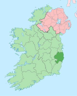
County Wicklow is a county in Ireland. The last of the traditional 32 counties, having been formed as late as 1606, it is part of the Eastern and Midland Region and the province of Leinster. It is bordered by the Irish Sea to the east and the counties of Wexford to the south, Carlow to the southwest, Kildare to the west, and South Dublin and Dún Laoghaire–Rathdown to the north.
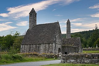
Glendalough is a glacial valley in County Wicklow, Ireland, renowned for an Early Medieval monastic settlement founded in the 6th century by St Kevin. From 1825 to 1957, the head of the Glendalough Valley was the site of a galena lead mine. Glendalough is also a recreational area for picnics, for walking along networks of maintained trails of varying difficulty, and also for rock-climbing.
A motte-and-bailey castle is a European fortification with a wooden or stone keep situated on a raised area of ground called a motte, accompanied by a walled courtyard, or bailey, surrounded by a protective ditch and palisade. Relatively easy to build with unskilled labour, but still militarily formidable, these castles were built across northern Europe from the 10th century onwards, spreading from Normandy and Anjou in France, into the Holy Roman Empire in the 11th century. The Normans introduced the design into England and Wales. Motte-and-bailey castles were adopted in Scotland, Ireland, the Low Countries and Denmark in the 12th and 13th centuries. Windsor Castle, in England, is an example of a motte-and-bailey castle. By the end of the 13th century, the design was largely superseded by alternative forms of fortification, but the earthworks remain a prominent feature in many countries.

Turlough Hill, also known as Tomaneena, is a 681-metre-high (2,234 ft) mountain in County Wicklow in Ireland and site of Ireland's only pumped-storage hydroelectricity plant. The power station is owned and operated by the ESB and can generate up to 292 megawatts (392,000 hp) of electricity at times of peak demand.

Wicklow is the county town of County Wicklow in Ireland. It is located on the east just south of Dublin. According to the 2016 census, it has a population of 10,584. The town is to the east of the M11 route between Dublin and Wexford. It also has railway links to Dublin, Wexford, Arklow, and Rosslare Europort. There is also a commercial port for timber and textile imports. The River Vartry is the main river flowing through the town.

The court cairn or court tomb is a megalithic type of chambered cairn or gallery grave. During the period, 3900–3500 BCE, more than 390 court cairns were built in Ireland and over 100 in southwest Scotland. The Neolithic monuments are identified by an uncovered courtyard connected to one or more roofed and partitioned burial chambers. Many monuments were built in multiple phases in both Ireland and Scotland and later re-used in the Early Bronze Age.
Dunamuggy is a townland of 172 acres in County Antrim, Northern Ireland. It is situated in the civil parish of Donegore and the historic barony of Antrim Upper.
The Dunlavin Green executions was summary execution of 36 suspected United Irishmen rebels in County Wicklow, Ireland by the Irish Yeomanry shortly after the outbreak of the rebellion of 1798. There are several accounts of the events, recorded at differing times and differing in detail.

Dunlavin is a village in County Wicklow, Ireland, situated about 50 kilometres (31 mi) south-west of Dublin. It is centred on the junction of the R412 and R756 regional roads. It was founded around the end of the 17th century and became a prominent town in the area for a time.

The R756 road is a regional road in Ireland running west–east from Dunlavin to Laragh. Its entire 32 km (20 mi) length is within County Wicklow crossing east–west through the Wicklow Gap.

In archaeology, earthworks are artificial changes in land level, typically made from piles of artificially placed or sculpted rocks and soil. Earthworks can themselves be archaeological features, or they can show features beneath the surface.

The R412 road is a regional road in Ireland, which runs north-south from the R448 in County Kildare to the N81 in County Wicklow. En route is passes through the town of Dunlavin where it is joined by the road from Glendalough which crosses over the Wicklow Gap. The route is 20 km (12 mi) long.
Buddugre Castle was a motte and bailey defensive fortification overlooking the River Ithon, located in the community of Llanddewi Ystradenny, in Radnorshire, Wales. It is believed to have been built as a defensive measure in the medieval period, during the 12th century, as a timber castle.

Killiney Hill is the southernmost of the two hills which form the southern boundary of Dublin Bay, the other being Dalkey Hill. These two hills form part of Killiney Hill Park.
Granard Motte is the remains of a motte-and-bailey castle and National Monument in Granard, County Longford, Ireland.
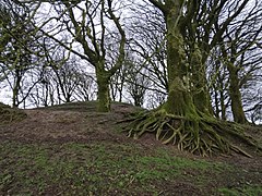
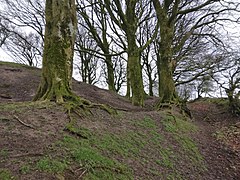
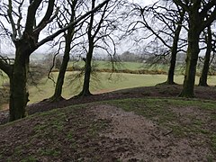
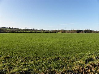
Castleruddery Motte is a motte and National Monument located in County Wicklow, Ireland.
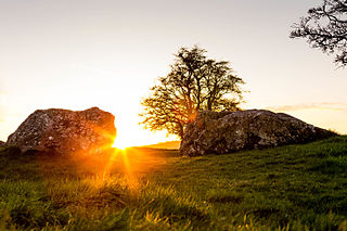
Castleruddery Stone Circle is a recumbent stone circle and National Monument located in County Wicklow, Ireland.
Tornant Moat is an Irish National Monument composed of a ringfort and nearby barrows.
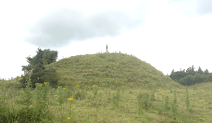
Rathcoran is a passage grave and hillfort and National Monument located atop Baltinglass Hill, County Wicklow, Ireland.
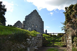
Aghowle Church is a medieval church and National Monument in County Wicklow, Ireland. It was one of the largest rural parish churches of its era. Aghowle is also a civil parish in the ancient barony of Shillelagh.