
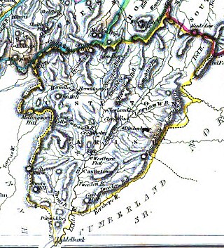
Roxburghshire or the County of Roxburgh is a historic county and registration county in the Southern Uplands of Scotland. It borders Dumfriesshire to the west, Selkirkshire and Midlothian to the northwest, and Berwickshire to the north. To the southwest it borders Cumberland and to the southeast Northumberland, both in England.

Selkirkshire or the County of Selkirk is a historic county and registration county of Scotland. It borders Peeblesshire to the west, Midlothian to the north, Roxburghshire to the east, and Dumfriesshire to the south. It derives its name from its county town, the royal burgh of Selkirk. The county was historically also known as Ettrick Forest.

Cessford Castle is a large ruined mid-15th century L-plan castle near the village of Cessford, midway Jedburgh and Kelso, in the historic county of Roxburghshire, now a division of the Scottish Borders. The Castle is caput of the Barony of Cessford, and the principal stronghold of the Kers/Kerrs, notorious Border Reivers, many of whom served as Wardens of the Middle March.

Ednam is a small village near Kelso in the Scottish Borders area of Scotland.

Lasswade is a village and civil parish in Midlothian, Scotland, on the River North Esk, nine miles south of Edinburgh city centre, contiguous with Bonnyrigg and between Dalkeith to the east and Loanhead to the west. Melville Castle lies to the north east. The Gaelic form is Leas Bhaid, meaning the "clump at the fort."
Cessford Burn is a small stream which eventually runs to meet the Kale Water and then joins the River Teviot, finally entering the River Tweed at Kelso, Scotland.
Holydean Castle was a castle sited near Melrose in Bowden, 1.25 miles SW of the village, in the Scottish Borders region of Scotland, and the former Roxburghshire.
The Battle of Hadden Rig was a battle fought about three miles east of Kelso, in the Scottish Borders, between Scotland and England on 24 August 1542, during the reigns of King James V of Scotland and Henry VIII of England. The English army was led by Robert Bowes, Deputy Warden of the English East March. It was a significant Scottish victory, but it was overshadowed by the disastrous Scottish defeat at the Battle of Solway Moss in November.

Birgham is a village in Berwickshire, parish of Eccles in the Scottish Borders area of Scotland, near Coldstream and the River Tweed, on the A698. Birgham is close to Ednam, Kelso, Lempitlaw, Leitholm and Sprouston as well as Carham and Wark on Tweed, Northumberland.
Minto is a village and parish in the Scottish Borders area of Scotland in Roxburghshire county. It is located 6 miles north-east of Hawick, north of the River Teviot.
Maxton is a hamlet and civil parish in Roxburghshire, Scotland, and part of the Scottish Borders region.

Cavers is a parish in the Scottish Borders area of Scotland, in the former county of Roxburghshire, south and east of Hawick. The largest village in the parish is Denholm.

Liddel Castle is a ruined castle in Liddesdale, by the Liddel Water, near Castleton in the Scottish Borders area of Scotland, in the former county of Roxburghshire. Liddel Castle is a scheduled monument.
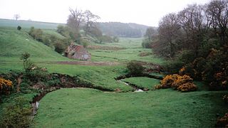
Castleton is a civil parish in the Scottish Borders area of Scotland, in the former Roxburghshire, in the extreme south of the Borders area. It is bounded by Northumberland (England), Dumfries and Galloway, and the parishes of Hobkirk, Southdean and Teviothead. The village of Castleton was commenced in 1793. It was built as a result of the land clearances in the 1790s when people were forced to move from Old Castleton village. While the parish retained the name Castleton, the village later became identified as New Castleton or Newcastleton. The parish is also known by its older name Liddesdale

Sprouston is a village, parish and former feudal barony in the Scottish Borders area of Scotland, as well as the historic county of Roxburghshire, located 2 miles north-east of Kelso.
Makerstoun is a parish in the Scottish Borders area of Scotland, as well as the historic county of Roxburghshire, 4 miles (6 km) south-west of Kelso.

Westgate Hall is located in Westgate in the village of Denholm, Roxburghshire, in the Scottish Borders. It stands at the western and south-western approaches to the village. Dating from the 17th century, it is an example of a building of that period that was once common in Scotland and is now a category A listed building.

Nenthorn is a parish and hamlet in the south of the historic county of Berwickshire in the Scottish Borders area of Scotland. It is included in the Floors, Makerstoun, Nenthorn and Smailholm Community Council area, which also includes the parishes of Makerstoun and Smailholm. It was included in the former Roxburgh District of Borders Region, by the Local Government (Scotland) Act 1973, from 1975 to 1996.
Mertoun is a parish in the south-west of the historic county of Berwickshire in the Scottish Borders area of Scotland. Together with the parish of Maxton, Roxburghshire it forms the Maxton and Mertoun Community Council area. It was included in the former Ettrick and Lauderdale District of Borders Region, by the Local Government (Scotland) Act 1973, from 1975 to 1996.
Hadden is a hamlet in Scotland near Kelso, and is now part of the Scottish Borders district. "Hadden is an inhabited place in the parish of Sprouston."
