
Sedimentary rocks are types of rock that are formed by the accumulation or deposition of mineral or organic particles at Earth's surface, followed by cementation. Sedimentation is the collective name for processes that cause these particles to settle in place. The particles that form a sedimentary rock are called sediment, and may be composed of geological detritus (minerals) or biological detritus. The geological detritus originated from weathering and erosion of existing rocks, or from the solidification of molten lava blobs erupted by volcanoes. The geological detritus is transported to the place of deposition by water, wind, ice or mass movement, which are called agents of denudation. Biological detritus was formed by bodies and parts of dead aquatic organisms, as well as their fecal mass, suspended in water and slowly piling up on the floor of water bodies. Sedimentation may also occur as dissolved minerals precipitate from water solution.

The lithology of a rock unit is a description of its physical characteristics visible at outcrop, in hand or core samples, or with low magnification microscopy. Physical characteristics include colour, texture, grain size, and composition. Lithology may refer to either a detailed description of these characteristics, or a summary of the gross physical character of a rock. Examples of lithologies in the second sense include sandstone, slate, basalt, or limestone.

In geology and related fields, a stratum is a layer of rock or sediment characterized by certain lithologic properties or attributes that distinguish it from adjacent layers from which it is separated by visible surfaces known as either bedding surfaces or bedding planes. Prior to the publication of the International Stratigraphic Guide, older publications have defined a stratum as either being either equivalent to a single bed or composed of a number of beds; as a layer greater than 1 cm in thickness and constituting a part of a bed; or a general term that includes both bed and lamina. Related terms are substrate and substratum (pl.substrata), a stratum underlying another stratum.
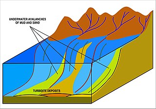
A turbidite is the geologic deposit of a turbidity current, which is a type of amalgamation of fluidal and sediment gravity flow responsible for distributing vast amounts of clastic sediment into the deep ocean.
A way up structure, way up criterion, or geopetal indicator is a characteristic relationship observed in a sedimentary or volcanic rock, or sequence of rocks, that makes it possible to determine whether they are the right way up or have been overturned by subsequent deformation. This technique is particularly important in areas affected by thrusting and where there is a lack of other indications of the relative ages of beds within the sequence, such as in the Precambrian where fossils are rare.
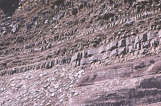
In geology, the term Torridonian is the informal name for the Torridon Group, a series of Mesoproterozoic to Neoproterozoic arenaceous and argillaceous sedimentary rocks, which occur extensively in the Northwest Highlands of Scotland. The strata of the Torridonian Group are particularly well exposed in the district of upper Loch Torridon, a circumstance which suggested the name Torridon Sandstone, first applied to these rocks by James Nicol. Stratigraphically, they lie unconformably on gneisses of the Lewisian complex and their outcrop extent is restricted to the Hebridean Terrane.
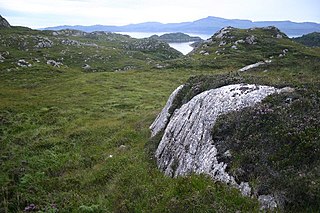
In geology, basement and crystalline basement are crystalline rocks lying above the mantle and beneath all other rocks and sediments. They are sometimes exposed at the surface, but often they are buried under miles of rock and sediment. The basement rocks lie below a sedimentary platform or cover, or more generally any rock below sedimentary rocks or sedimentary basins that are metamorphic or igneous in origin. In the same way, the sediments or sedimentary rocks on top of the basement can be called a "cover" or "sedimentary cover".
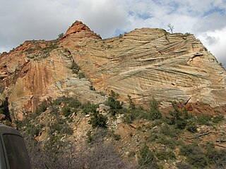
In geology, cross-bedding, also known as cross-stratification, is layering within a stratum and at an angle to the main bedding plane. The sedimentary structures which result are roughly horizontal units composed of inclined layers. The original depositional layering is tilted, such tilting not being the result of post-depositional deformation. Cross-beds or "sets" are the groups of inclined layers, which are known as cross-strata.

In geology, a bed is a layer of sediment, sedimentary rock, or volcanic rock "bounded above and below by more or less well-defined bedding surfaces". Specifically in sedimentology, a bed can be defined in one of two major ways. First, Campbell and Reineck and Singh use the term bed to refer to a thickness-independent layer comprising a coherent layer of sedimentary rock, sediment, or pyroclastic material bounded above and below by surfaces known as bedding planes. By this definition of bed, laminae are small beds that constitute the smallest (visible) layers of a hierarchical succession and often, but not always, internally comprise a bed.

The Clarens Formation is a geological formation found in several localities in Lesotho and in the Free State, KwaZulu-Natal, and Eastern Cape provinces in South Africa. It is the uppermost of the three formations found in the Stormberg Group of the greater Karoo Supergroup rocks and represents the final phase of preserved sedimentation of the Karoo Basin.

Sedimentary structures include all kinds of features in sediments and sedimentary rocks, formed at the time of deposition.

The Bedford Shale is a shale geologic formation in the states of Ohio, Michigan, Pennsylvania, Kentucky, West Virginia, and Virginia in the United States.
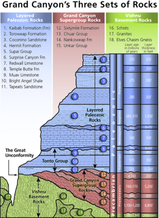
A stratigraphic column is a representation used in geology and its subfield of stratigraphy to describe the vertical location of rock units in a particular area. A typical stratigraphic column shows a sequence of sedimentary rocks, with the oldest rocks on the bottom and the youngest on top.
The Triassic Lockatong Formation is a mapped bedrock unit in Pennsylvania, New Jersey, and New York. It is named after the Lockatong Creek in Hunterdon County, New Jersey.
Turbidite Hill is a low nunatak that lies four nautical miles (7 km) east of Laird Plateau on the north side of Olson Neve in Antarctica. It was mapped by the Holyoake, Cobham and Queen Elizabeth Ranges party of the New Zealand Geological Survey Antarctic Expedition (NZGSAE) (1964–65). It was named after sedimentary features, called turbidites, which were reportedly found in sedimentary rocks of the Beacon Supergroup which forms the summit of this hill.
Heterolithic bedding is a sedimentary structure made up of interbedded deposits of sand and mud. It is formed mainly in tidal flats but can also be formed in glacial environments. Examples from fluvial environments have been documented but are rare. Heterolithic bedding forms in response to alternations in sediment supply and tidal velocity. The fluctuations result in the interbedded layers of sand and mud. The rippled sand layer is formed during high tidal currents, while the mud is deposited during slack tide periods. The three main types of heterolithic bedding are flaser, wavy, and lenticular. Starved ripples and cross bedding with flasers can also be considered forms of heterolithic bedding. Differentiating of these various types of heterolithic bedding is based on the relative volume of mud and sand. This key determining factor is controlled by the timing, and duration of both the high tide, and slack tide depositional periods.

The Bright Angel Shale is one of five geological formations that comprise the Cambrian Tonto Group. It and the other formations of the Tonto Group outcrop in the Grand Canyon, Arizona, and parts of northern Arizona, central Arizona, southeast California, southern Nevada, and southeast Utah. The Bright Angel Shale consists of locally fossiliferous, green and red-brown, micaceous, fissile shale (mudstone) and siltstone with local, thicker beds of brown to tan sandstone and limestone. It ranges in thickness from 57 to 450 feet. Typically, its thin-bedded shales and sandstones are interbedded in cm-scale cycles. They also exhibit abundant sedimentary structures that include current, oscillation, and interference ripples. The Bright Angel Shale also gradually grades downward into the underlying Tapeats Sandstone. It also complexly interfingers with the overlying Muav Limestone. These characters make the upper and lower contacts of the Bright Angel Shale often difficult to define. Typically, its thin-bedded shales and sandstones erode into green and red-brown slopes that rise from the Tonto Platform up to cliffs formed by limestones of the overlying Muav Limestone and dolomites of the Frenchman Mountain Dolostone.
A geological contact is a boundary which separates one rock body from another. A contact can be formed during deposition, by the intrusion of magma, or through faulting or other deformation of rock beds that brings distinct rock bodies into contact.

The Gai-As Formation is an Early to Middle Permian geologic formation correlated with the Ecca Group and designated "Ecca" Group, because it does not belong to the Karoo, in the southwestern Kunene Region and northern Erongo Region of northwestern Namibia. The Gai-As Formation represents the second-oldest sedimentary unit of the Huab Basin, overlying the Huab Formation. The formation was deposited in a fluvial to lacustrine setting.

The Adigrat Sandstone formation in north Ethiopia, in a wide array of reddish colours, comprises sandstones with coarse to fine grains, and locally conglomerates, silt- and claystones. Given the many lateritic palaeosols and locally fossil wood fragments, the formation is interpreted as a deposit in estuarine, lacustrine-deltaic or continental environments. The upper limit of Adigrat Sandstone is of Middle-Late Jurassic age whereas the lower boundary is Triassic. There are numerous rock-hewn churches in this formation.


