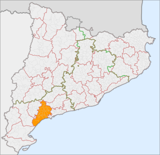
Baix Camp is a comarca of Catalonia. It is one of the three comarques into which Camp de Tarragona was divided in the comarcal division of 1936.

Berguedà is an inland comarca (county) in Catalonia, Spain, lying partly in the Pyrenees and Pre-Pyrenees, and partly in the Catalan Central Depression.

Sant Andreu Arenal is a Rodalies de Catalunya station in the Barcelona district of Sant Andreu. It is served by Barcelona commuter rail lines R3, R4 and R7 as well as regional line R12. Passengers can also commute here to Barcelona Metro line 1 station Fabra i Puig and the Sant Andreu bus terminal. It is located where Avinguda Meridiana and Avinguda de Rio de Janeiro meet, by Rambla de Fabra i Puig.
Tretzevents or Puig de Tres Vents is a mountain of the Canigó Massif, Pyrenees, Catalonia, France. Located between the communes of Cortsaví (Corsavy) and El Tec, Pyrénées-Orientales, it has an elevation of 2,731 metres above sea level. A secondary 2,727 m high summit is located at the limit of the Castell de Vernet (Casteil) commune.

Puig de Fontnegra is a mountain of Catalonia, Spain. Located in the Pyrenees, it has an elevation of 2,727 metres above sea level.
Puig de Pastuira is a mountain of Catalonia, Spain. It can be found to the north-west of the village of Setcases in the eastern Pyrenees.
Puig d'Ombriaga is a mountain of Catalonia, Spain. Located in the Pyrenees, it has an elevation of 2,638 metres above sea level.

Puig de Fontlletera is a mountain of Catalonia, Spain. Located in the Pyrenees, it has an elevation of 2,577 metres above sea level.

Puig de Dòrria is a mountain of Catalonia, Spain. Located in the Pyrenees, it has an elevation of 2,547 metres (8,356 ft) above sea level.

Puig Cerverís is a mountain of Catalonia, Spain. Located in the Pyrenees, it has an elevation of 2,208 metres above sea level.

Puig Cornador is a mountain of Catalonia, Spain. It has an elevation of 1,799 metres above sea level.

Puig de l'Obiol is a mountain of Catalonia, Spain. It has an elevation of 1,543 metres above sea level.

Puig de l'Àliga is a mountain of Catalonia, Spain. It has an elevation of 1,344 metres above sea level.

Puig Neulós is the highest mountain of Albera Range, an eastern prolongation of the Pyrenees in Catalonia, between France and Spain. It has an elevation of 1,256 metres above sea level.
Puig Cornador is a mountain of Catalonia, Spain. It has an elevation of 1,229 metres above sea level.

Puig Castellar (Balenyà) is a mountain of Catalonia, Spain. It has an elevation of 1,017 metres above sea level.
Puig Sesarques is a mountain of Catalonia, Spain. It has an elevation of 880 metres above sea level.
Puig Cornador is a mountain of Catalonia, Spain. It has an elevation of 859 metres above sea level.
Puig-l'agulla is a mountain of Catalonia, Spain. It has an elevation of 810 metres above sea level.
Puig Cornador is a mountain of Catalonia, Spain. It has an elevation of 621 metres above sea level.
