La Place Bellecour is a large square in the centre of Lyon, France, to the north of the Ainay district. Measuring 312 m by 200 m, it is one of the largest open squares in Europe, and the third biggest square in France, behind the Place des Quinconces in Bordeaux (126,000 m²) and the Place de la Concorde in Paris (86,400 m²). It is also the largest pedestrian square in Europe: vehicles are allowed in Places de la Concorde and des Quinconces.

The nine arrondissements of Lyon are the administrative divisions of the City of Lyon. Unlike the spiral pattern of the arrondissements of Paris, or the meandering pattern of those in Marseille, the layout in Lyon is more idiosyncratic. This is for historical reasons: following the annexation of the communes of La Guillotière, La Croix-Rousse and Vaise in 1852, the newly enlarged city was divided into 5 arrondissements, which originally spiralled out anticlockwise from the Hôtel de Ville ; however, as the city's population expanded, it became necessary to split certain arrondissements, giving rise to today's seemingly random pattern.
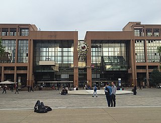
Gare de la Part-Dieu is the primary railway station in Lyon, France. It is situated on the Paris-Lyon-Marseille railway. The train services are mainly operated by SNCF with frequent TGV high-speed and TER regional services with Eurostar and Deutsche Bahn also operating few services through the station. Lyon's secondary station is Gare de Lyon-Perrache south of the city center.

Lyon is the third-largest city and second-largest urban area of France. It is located in the country's east-central part at the confluence of the rivers Rhône and Saône, about 470 km (292 mi) south from Paris, 320 km (199 mi) north from Marseille and 56 km (35 mi) northeast from Saint-Étienne. Inhabitants of the city are called Lyonnais.

Parc de la Tête d'or, in Lyon, is a large urban park in France with an area of approximately 117 hectares. Located in the 6th arrondissement, it features a lake on which boating takes place during the summer months. Due to the relatively small number of other parks in Lyon, it receives a huge number of visitors over summer, and is a frequent destination for joggers and cyclists. In the central part of the park, there is a small zoo, with giraffes, elephants, deer, reptiles, primates, and other animals. There are also sports facilities, such as a velodrome, boules court, mini-golf, horse riding, and a miniature train.

The Presqu’île is the heart of Lyon, France. Extending from the foot of the Croix Rousse hill to the confluence of the Rhône and the Saône rivers, it has a preponderance of cafés, restaurants, luxury shops, department stores, banks, government buildings, and cultural institutions. The 1st and 2nd arrondissements of the city are located here, along with the Hôtel de Ville. The spires of the church of St. Nizier, reconstructed starting in the 14th century, are at the foot of the former Saône river bridge. Though the business centre is located to the east in the 3rd arrondissement, road signs pointing to the centre of the city take drivers to Place Bellecour in the 2nd.

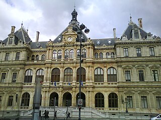
The Palais de la Bourse or Palais du Commerce is a building located in the quarter Les Cordeliers, in 2nd arrondissement of Lyon. It currently houses the headquarters of the Chamber of Commerce and Industry of Lyon. It is served by the metro station Cordeliers, and by bus lines C3, 18, 23, 25, 28, 58, 71, 91 and 99.
Saint-Paul is a quarter located in the 5th arrondissement of Lyon, France. It was named after the parish church. Located in the perimeter saved registered to the UNESCO World Heritage Site, it is one of the three parishes of the Vieux Lyon, the historic center of the city. The quarter is mainly served by the line C3 of the transports en commun lyonnais and the train station named Gare de Lyon-Saint-Paul. In 1880, the statue of Chancellor Gerson, sculpted by the burgomaster of Liège, Charles Bailly, was installed rue Saint-Paul, in front of the church.
Les Cordeliers is one of the central quarters in the 2nd arrondissement of Lyon, France. It is mainly known for the Place des Cordeliers in its centre. Around the square, there are many notable monuments, including the Église Saint-Bonaventure and the Palais de la Bourse.

Rue Mercière is a street of Les Cordeliers quarter in the 2nd arrondissement of Lyon. From north to south, it connects the Place des Jacobins to the Place d'Albon. This street is served by metro stations Bellecour and Cordeliers of the line A and by the bus station Jacobins of the lines 91 and 99. It belongs to the zone classified as World Heritage Site by UNESCO.

The Rue des Marronniers is a street located in the Bellecour quarter, in the 2nd arrondissement of Lyon. It is a small paved pedestrian street famous for its many bouchons. It is served by the metro station Bellecour and many buses. The street belongs to a zone classified as a World Heritage Site by UNESCO.
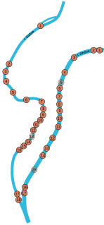
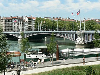
This is a list of bridges in the French city of Lyon on the Rhône and Saône rivers, ordered from upstream to downstream portions of the river.

The Place des Jacobins is a square located in the 2nd arrondissement of Lyon. It was created in 1556 and a fountain was added in 1856. The square belongs to the zone classified as World Heritage Site by UNESCO. According to Jean Pelletier, this square is one of the most famous in Lyon, because of its location in the center of the 2nd arrondissement and its heavy traffic, as 12 streets lead here. The square, particularly its architecture and its features, has changed its appearance many times throughout years.

The Avenue du Maréchal de Saxe is a broad avenue located in the 3rd and the 6th arrondissements of Lyon. It was named after Maurice de Saxe, Marshal of France.

The Rue de Vendôme is a very long street located in Lyon. It begins with the Avenue de Grande Bretagne, along the Rhône, in the 6th arrondissement, and ends with the Cours Gambetta, in the 3rd arrondissement, after crossing the Place Guichard.
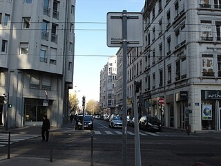
The Rue Duguesclin is a long street in Lyon crossing directly wholly the 6th and the 3rd arrondissement, and ends in the 7th arrondissement. This 2,800-meter street starts at the Boulevard des Belges and ends on the rue Rachais. The Lyon inhabitants and the telephone directory usually write the street name in a sole word (Duguesclin) and the cartographers do it in two words.

The Église Saint-Pothin is a Roman Catholic church located in Lyon, France. The parish church sits on the left bank of the Rhône, in the 6th arrondissement of Lyon, at the Place Edgar Quinet. By order of 2 May 2007, the whole church was included in the supplementary inventory of monuments historiques.
The Berges du Rhône or Quais du Rhône refer to a series of parks, quays, streets and walking paths along the Rhône river in Lyon, France. The construction for the modern Berges du Rhône took place between 2005 and 2007, resulting in the development of 10 hectares of land on the left and right banks of the Rhône from Parc de la Tête d'Or to Parc de Gerland.