Leubingen

Last updated
Leubingen tumulus
Fürstengrab von Leubingen
Grabhuegel Leubingen.jpg
The Leubingen tumulus
Germany adm location map.svg
Archaeological site icon (red).svg
Location in Germany
LocationLeubingen, Sömmerda
Region Thuringia, Germany
Coordinates 51°11′25″N11°10′11″E / 51.19028°N 11.16972°E / 51.19028; 11.16972 Coordinates: 51°11′25″N11°10′11″E / 51.19028°N 11.16972°E / 51.19028; 11.16972
Type tumulus
History
Foundedc. 2000 BC
Periods Early Bronze Age
Cultures Unetice culture
Site notes
Discovered1877
Archaeologists Friedrich Klopfleisch  [ de ]

The Leubingen tumulus (German: Fürstengrab von Leubingen) is an early bronze age "princely" grave of the Leubingen culture, (which, after further finds at Auntjetitz became known as Auntjetitz or Unetice culture), dating to about 1940 BC. It is located near the hills of Kyffhäuser in Leubingen, an Ortsteil of Sömmerda in the eastern German state of Thuringia.

Tumulus Mound of earth and stones raised over graves

A tumulus is a mound of earth and stones raised over a grave or graves. Tumuli are also known as barrows, burial mounds or kurgans, and may be found throughout much of the world. A cairn, which is a mound of stones built for various purposes, may also originally have been a tumulus.

Unetice culture archaeological culture

The Únětice culture is an archaeological culture at the start of the Central European Bronze Age, dated roughly to about 2300–1600 BC. The eponymous site for this culture, the village of Únětice, is located in the central Czech Republic, northwest of Prague. Today, the Únětice culture is known from about 1,400 sites in the Czech Republic and Slovakia, 550 sites in Poland, and, in Germany, about 500 sites and loose finds locations. The Únětice culture is also known from north-eastern Austria, and from western Ukraine.

Kyffhäuser mountain range

The Kyffhäuser, sometimes also referred to as Kyffhäusergebirge, is a hill range in Central Germany, located on the border of the state of Thuringia with Saxony-Anhalt, southeast of the Harz mountains. It reaches its highest point at the Kulpenberg with an elevation of 473.4 metres (1,553 ft). The range is the site of medieval Kyffhausen Castle and the 19th century Kyffhäuser Monument; it has significance in German traditional mythology as the legendary resting place of Emperor Frederick Barbarossa.

Contents

Excavations

The site was first unearthed in 1877 by Jena art professor and archaeologist Friedrich Klopfleisch  [ de ] (1831–1898). He was working at the behest of the Historische Kommission der Provinz Sachsen. Klopfleisch kept a diary during his work and latter submitted an official report on the findings. Unfortunately, there are important differences between his original notes and the final report. Both the location of the burial chamber and of the grave goods within the chamber vary. During the excavations no second body is mentioned (see Description below), only a few bone remains. Today, the diary is deemed the more reliable source. [1] :183

Jena Place in Thuringia, Germany

Jena is a German university city and the second largest city in Thuringia. Together with the nearby cities of Erfurt and Weimar, it forms the central metropolitan area of Thuringia with approximately 500,000 inhabitants, while the city itself has a population of about 110,000. Jena is a centre of education and research; the Friedrich Schiller University was founded in 1558 and had 18,000 students in 2017 and the Ernst-Abbe-Fachhochschule Jena counts another 5,000 students. Furthermore, there are many institutes of the leading German research societies.

After the excavations were finished, the mound was filled in again. In 1912, the local Königlicher Landrat ordered the Leubingen authorities to prevent its agricultural use. [1] :183

During road construction in 2011 excavations on the site nearby have also revealed the remains of one of the largest buildings in prehistoric Germany, a longhouse 44 m x 10.50 m, or 470 square meters (5,057 square feet) of floor space, a trove of bronze objects, and a cemetery of 44 farmers. [2]

Dating and evaluation

Dendrochronologic testing of the oaken beams has placed the grave at circa 1942 BC. [1] :180

Dendrochronology method of dating based on the analysis of patterns of tree rings

Dendrochronology is the scientific method of dating tree rings to the exact year they were formed. As well as dating them this can give data for dendroclimatology, the study of climate and atmospheric conditions during different periods in history from wood.

The tomb is considered one of the most opulent elite grave of the Early Bronze Age in Western Europe. Due to the effort required for its construction and the quality of the grave goods, the buried person must have been of great importance. [1] :180

Description

Illustration 1 from Klopfleisch's hand-drawn/-written report Skizze 1 im Grabungstagebuch.jpg
Illustration 1 from Klopfleisch's hand-drawn/-written report
Illustration 2 from Klopfleisch's hand-drawn/-written report Skizze 2 im Grabungstagebuch.jpg
Illustration 2 from Klopfleisch's hand-drawn/-written report
Golden bracelet Goldener Armring.jpg
Golden bracelet
Golden rings and spiral Zwei goldene Ringe und ein Spiralrollchen.jpg
Golden rings and spiral

Mound and chamber

The earthen mound is 7 metres (23 ft) high and contains a burial chamber of 3.90 by 2.10 metres (12.8 by 6.9 ft) with a maximum height of 1.70 metres (5.6 ft).

The original height of the mound was around 8.5 metres (28 ft) and its diameter was 34 metres (112 ft). Around 210 cubic-meters of stones and 3,600 cubic-meters of earth were moved in its construction. [1] :180

Inside the earthen mound is the burial Chamber, which has roughly the form of a hut/house of the time. It has a saddle-shaped roof made out of heavy oak beams covered with stones. [1] :180

Contents of the grave

In a central position lay the body of a man about 50 years old.

According to Klopfleisch's final report, draped over the man's loins at an angle of ca. 40° was the body of a young man. This was not mentioned in his earlier notes, however. [1] :183

The findings are now part of the permanent exhibition of the Halle State Museum of Prehistory.

Surroundings

Between the 8th and 11th century AD, the local (at the time Slavic) community established a cemetery of about 70 graves in and around this manmade hill.

See also

Related Research Articles

Chambered cairn Burial monument, usually constructed during the Neolithic, consisting of a sizeable (usually stone) chamber around and over which a cairn of stones was constructed

A chambered cairn is a burial monument, usually constructed during the Neolithic, consisting of a sizeable chamber around and over which a cairn of stones was constructed. Some chambered cairns are also passage-graves. They are found throughout Britain and Ireland, with the largest number in Scotland.

Kurgan Tumulus in Eastern Europe

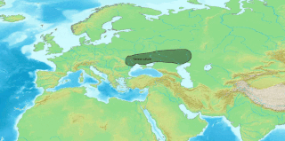
A kurgan is a tumulus, a type of burial mound or barrow, heaped over a burial chamber, often of wood. The Russian noun, already attested in Old East Slavic, borrowed by the Turks, compare Modern Turkish kurğan, which means "fortress". Kurgans are mounds of earth and stones raised over a grave or graves. Popularised by its use in Soviet archaeology, the word is now widely used for tumuli in the context of Eastern European and Central Asian archaeology.

Megalith Large stone used to build a structure or monument

A megalith is a large stone that has been used to construct a structure or monument, either alone or together with other stones. The word megalithic describes structures made of such large stones without the use of mortar or concrete, representing periods of prehistory characterised by such constructions. For later periods, the word monolith, with an overlapping meaning, is more likely to be used.

Gallery grave Form of megalithic tomb

A gallery grave is a form of megalithic tomb built primarily during the Neolithic Age in Europe in which the main gallery of the tomb is entered without first passing through an antechamber or hallway. There are at least four major types of gallery grave, and they may be covered with an earthen mound or rock mound.

Pinson Mounds Archaeological park

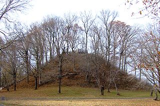
The Pinson Mounds comprise a prehistoric Native American complex located in Madison County, Tennessee in the region that is known as the Eastern Woodlands. The complex, which includes 17 mounds, an earthen geometric enclosure, and numerous habitation areas, was most likely built during the Middle Woodland period. The complex is the largest group of Middle Woodland mounds in the United States. Sauls' Mound, at 72 feet, is the second-highest surviving mound in the United States.

Julliberries Grave Barrow in England

Julliberrie's Grave, also known as The Giant's Grave or The Grave, is an unchambered long barrow located near to the village of Chilham in the south-eastern English county of Kent. Probably constructed in the fourth millennium BCE, during Britain's Early Neolithic period, today it survives only in a state of ruin.

Mound of the Hostages passage tomb in Leinster, Ireland

The Mound of the Hostages is an ancient passage tomb located in the Tara-Skryne Valley in County Meath, Leinster, Ireland.

Knowth passage grave

Knowth is a Neolithic passage grave and an ancient monument of the World Heritage Site of Brú na Bóinne located 8.4 km west of Drogheda in Ireland's valley of the River Boyne. It is the largest passage grave of the Brú na Bóinne complex. It consists of a large mound and 17 smaller satellite tombs. The mound is about 12 metres (40 ft) high and 67 metres (220 ft) in diameter, covering roughly a hectare. It contains two passages placed along an east-west line and is encircled by 127 kerbstones, of which three are missing, and four badly damaged.

The Kings Grave nordic bronze age grave in Kivik, southern Sweden

The King's Grave near Kivik in the southeastern portion of the Swedish province of Skåne is what remains of an unusually grand Nordic Bronze Age double burial c. 1400 BC.

Grave Creek Mound

The Grave Creek Mound in the Ohio River Valley in West Virginia is one of the largest conical-type burial mounds in the United States, now standing 62 feet (19 m) high and 240 feet (73 m) in diameter. The builders of the site, members of the Adena culture, moved more than 60,000 tons of dirt to create it about 250–150 BC.

Mine Howe is a prehistoric subterranean man-made chamber dug 6 meters deep inside a large mound. It is located in the Tankerness area of Orkney, about 5 miles (8 km) southeast of Kirkwall, the capital of Orkney. The origin of the howe is not perfectly understood. Experts believe that it was built roughly 2000 years ago during the Iron Age. There is some similarity to the well inside the Iron Age Broch of Gurness.

Hochdorf Chieftains Grave Burial chamber and museum

The Hochdorf Chieftain's Grave is a richly-furnished Celtic burial chamber near Hochdorf an der Enz in Baden-Württemberg, Germany, dating from 530 BC in the Hallstatt culture period. It was discovered in 1968 by an amateur archaeologist and excavated in 1978/79. By then, the originally 20 ft (6 m) high burial mound covering the grave, which is about 200 ft (60 m) in diameter, had shrunk to about 3 ft (1 m) height and was hardly discernible due to centuries of erosion and agricultural use.

Mound Bottom place in Tennessee listed on National Register of Historic Places

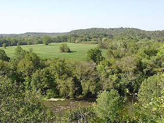
Mound Bottom is a prehistoric Native American complex in Cheatham County, Tennessee, located in the Southeastern United States. The complex, which consists of earthen platform and burial mounds, a 7-acre central plaza, and habitation areas, was occupied between approximately 1000 and 1300 AD, during the Mississippian period.

St Lythans burial chamber Megalithic dolmen in Wales

The St Lythans burial chamber is a single stone megalithic dolmen, built around 6,000 BP as part of a chambered long barrow, during the mid Neolithic period, in what is now known as the Vale of Glamorgan, Wales.

Prehistoric Orkney

Prehistoric Orkney refers to a period in the human occupation of the Orkney archipelago of Scotland that was the latter part of these islands' prehistory. The period of prehistory prior to occupation by the genus Homo is part of the geology of Scotland. Although some written records refer to Orkney during the Roman invasions of Scotland, prehistory in northern Scotland does not end until the commencement of the Early Historic Period around AD 600.

Beaverdam Creek Archaeological Site

The Beaverdam Creek Archaeological Site,, is an archaeological site located on a floodplain of Beaverdam Creek in Elbert County, Georgia approximately 0.8 km from the creek's confluence with the Savannah River, and is currently inundated by the Richard B. Russell Lake. The site consisted of a platform mound and an associated village site. Beaverdam Creek is thought to have been the center of a Mississippian culture simple chiefdom with a small resident population. The primary period of mound construction and village occupation dated to the regional Savannah period of the Middle Mississippian period, specifically 1200–1300 CE, with the site's abandonment occurring sometime after 1300. The mound was 1.5 metres (4.9 ft) high, and its base measured 25 metres (82 ft) by 25 metres (82 ft). The village boundaries were delineated as 15,000 square meters.

Necropolis of Soderstorf

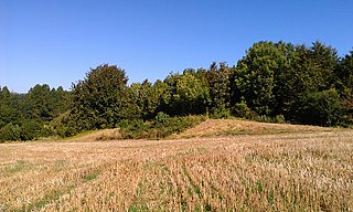
The Necropolis of Soderstorf is a prehistoric cemetery in the valley of the Luhe river valley near Soderstorf in the Lüneburg district of Lower Saxony, Germany. The site was used for more than 2000 years. It includes a megalithic tomb, a tumulus tomb, a stone circle, paving stones, funerary urns and a flat grave.

Shrubs Wood Long Barrow English long barrow

Shrub's Wood Long Barrow is an unchambered long barrow located near to the village of Elmsted in the south-eastern English county of Kent. It was probably constructed in the fourth millennium BCE, during Britain's Early Neolithic period. Built out of earth, the long barrow consists of a sub-trapezoidal tumulus flanked by side ditches.

References

  1. 1 2 3 4 5 6 7 Meller (ed.), Harald (2011). Bronzerausch - Spätneolithikum und Frühbronzezeit, Begleithefte zur Dauerausstellung im Landesmuseum für Vorgeschichte Halle (German). Landesamt für Denkmalpflege und Archäologie Sachsen-Anhalt. ISBN   978-3-939414-58-2.CS1 maint: Extra text: authors list (link)
  2. Schulz, Matthias (1 July 2011). "Archaeologists Puzzle Over Opulent Prehistoric Burial Find". Der Spiegel. Retrieved 5 July 2011.