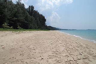
Leupung -- also spelled "Leupueng", is a district in Aceh Besar regency, close to the city of Banda Aceh, the capital of the special territory of Aceh, Indonesia, on the island of Sumatra. Leupung is located at 5'31" North latitude and 95'15" East longitude at an elevation of 33 m. The population in 2004 was approximately 10,000; the district has been obliterated by the tsunami resulting from the 2004 Indian Ocean earthquake, being one of the towns closest to the earthquake's epicenter.
According to early reports nothing vertical and square-edged is left, and the estimated number of survivors is 200–700.
There were six villages in Leupung: Deah, Meunasah Mesjid, Meunasah Bak U, Lamseunia, Pulot, and Layeun. Among these six villages, Pulot and Layeuen have more people that survived the tsunami. These villages were situated on higher land and had easy access to even higher places for them to evacuate to, while people in the other villages did not get close and lacked easy access to a safer place. Higher death toll in these four villages also resulted from the way the people understood and reacted to this natural disaster. Oral tradition after the tsunami has it that after the tremendous earthquake, people had already reached the conclusion that it was to be the end of the world. Therefore, many people decided that there was no longer time to escape, it was time just to beg for the mercy of God. That is why, as many people told, there were many people who did not survive in this area.
Aceh, formerly Nanggroe Aceh Darussalam, is the northernmost and westernmost province-level division of Indonesia. It is located at the tip of Sumatra, with Banda Aceh being its capital and largest city. Granted a special autonomous status, Aceh is a religiously conservative territory and the only Indonesian province practicing Sharia officially. There are ten indigenous ethnic groups in this region, the largest being the Acehnese people, accounting for approximately 80% to 90% of the region's population. Due to strict religious practices including flogging, despite among Indonesia's highest birthrates, population outflow is common, particularly out of Banda Aceh itself.
Banda Aceh is the capital and largest city in the province of Aceh, Indonesia. It is located on the island of Sumatra and has an elevation of 35 meters. The city covers an area of 61.36 square kilometers (23.69 sq mi) and had a population of 223,446 people at the 2010 Census, rising to 252,899 at the 2020 Census.
The 2004 Indian Ocean earthquake and tsunami occurred at 07:58:53 local time (UTC+7) on 26 December, with an epicentre off the west coast of northern Sumatra, Indonesia. It was an undersea megathrust earthquake that registered a magnitude of 9.1–9.3 Mw, reaching a Mercalli intensity up to IX in certain areas. The earthquake was caused by a rupture along the fault between the Burmese Plate and the Indian Plate.
Khao Lak is a series of villages, now tourist-oriented, mainly in the Takua Pa District and partly in the Thai Mueang District of Phang Nga Province, Thailand.
Meulaboh is the capital of West Aceh Regency, Indonesia.
Simeulue Regency is a regency in the Aceh special region of Indonesia. It occupies the whole island of Simeulue, 150 km off the west coast of Sumatra, with an area of 1,838.09 square kilometres. It had a population of 80,674 at the 2010 Census and 92,865 at the 2020 Census.
Calang, the capital of the Aceh Jaya Regency of the special territory of Aceh was on the island of Sumatra, Indonesia. It had a population of about 12,000 though it was reported to have "vanished completely leaving only scattered shards of concrete" as a result of the tsunami produced by the 2004 Indian Ocean earthquake. Only about 30 per cent of the townspeople have survived.
Indonesia was the first country to be seriously affected by the earthquake and tsunami created by the 2004 Indian Ocean earthquake on 26 December 2004, swamping the northern and western coastal areas of Sumatra, and the smaller outlying islands off Sumatra. Nearly all the casualties and damage took place within the province of Aceh. The time of arrival of the tsunami was between 15 and 30 minutes after the deadly earthquake.
A tsunami warning system (TWS) is used to detect tsunamis in advance and issue the warnings to prevent loss of life and damage to property. It is made up of two equally important components: a network of sensors to detect tsunamis and a communications infrastructure to issue timely alarms to permit evacuation of the coastal areas. There are two distinct types of tsunami warning systems: international and regional. When operating, seismic alerts are used to instigate the watches and warnings; then, data from observed sea level height are used to verify the existence of a tsunami. Other systems have been proposed to augment the warning procedures; for example, it has been suggested that the duration and frequency content of t-wave energy is indicative of an earthquake's tsunami potential.
Aceh Jaya Regency is a regency of Aceh Special Region, Indonesia. It is located on the island of Sumatra. The regency covers an area of 3,814 square kilometres and had a population of 76,782 people at the 2010 census and 93,159 at the 2020 Census, of whom 47,264 were male and 45,895 female. The seat of the Regency is Calang, in Krueng Sabee District. The main crops grown in the Regency are rice, rambutan, durian, orange, water melon, rubber, palm and coconut oil.
Gleebruk was a village in the district (Kabupaten/Kota) of Aceh Besar just to the southwest of Banda Aceh, the capital of the special territory of Aceh on the island of Sumatra, Indonesia. It was completely destroyed by the tsunamis resulting from the 2004 Indian Ocean earthquake.
The Indian Ocean Tsunami Warning System was set up to provide warning to inhabitants of nations bordering the Indian Ocean of approaching tsunamis. The tsunami warning system has been in use since the mid-2000s
Palu is a chartered city on the Indonesian island of Sulawesi, at the mouth of the Palu River. It is the capital of the province of Central Sulawesi, situated on a long, narrow bay. Because of its sheltered position between mountain ridges, the climate is unusually dry. At the 2010 census Palu had a population of 336,532. On 28 September 2018, the city suffered severe damage due to a series of earthquakes followed by a tsunami, resulting in major soil liquefaction and mudflows, which caused many of the surrounding buildings to become submerged. At the 2020 census Palu had a population of 373,218, not including those living in neighbouring regencies.
The Banyak Islands are a group of inhabited islands located between Simeulue and Nias off the western coast of Sumatra in Indonesia's Aceh Province. Surveys of the area approximate around 71 islands and additional mangrove stands in shallow off-shore areas, although locals count 99 islands. The largest island in the group is Tuangku, with the principal town of Haloban. Two other major islands located either side of Tuangku are Bangkaru and Ujung Batu. Tuangku is separated from Bangkaru by a fault line.
Library damage resulting from the 2004 Indian Ocean earthquake has been reported in six Asian countries. On December 26, the massive 2004 Indian Ocean earthquake struck off the northwest coast of the Indonesian island of Sumatra. The resulting tsunamis killed more than 180,000 people. In addition to the loss of human lives, cultural institutions were destroyed in several Asian nations. Libraries on the Eastern coast of Sri Lanka and the northern province of Aceh on Sumatra were most severely affected by the disaster.
Simeulue is an island of Indonesia, 150 kilometres (93 mi) off the west coast of Sumatra. It covers an area of 1,838.09 square kilometres, including minor offshore islands. It had a population of 80,674 at the 2010 Census and 92,865 at the 2020 Census. Its capital is Sinabang.
The Aceh river on the island of Sumatra in Indonesia flows from mountains that include the 2780-metre high Mount Peuët Sagoë for some two hundred kilometres northeastward to reach the junction of the Indian Ocean and the Andaman Sea at Banda Aceh, the capital of Aceh Province. The river has a catchment area of some 1775 square kilometres.
Ulèë Lheuë is an area in Meuraxa sub-district, Banda Aceh, Indonesia. It was the former main seaport of Aceh. The town and seaport was heavily damaged and depopulated during the 2004 Indian Ocean earthquake and tsunami.
The 2012 Indian Ocean earthquakes were magnitude 8.6 and 8.2 Mw undersea earthquakes that struck near the Indonesian province of Aceh on 11 April at 15:38 local time. Initially, authorities feared that the initial earthquake would cause a tsunami and warnings were issued across the Indian Ocean; however, these warnings were subsequently cancelled. These were unusually strong intraplate earthquakes and the largest strike-slip earthquake ever recorded.
On April 13, 1923 at 15:31 UTC, an earthquake occurred off the northern coast of the Kamchatka Peninsula in the USSR, present-day Russia. The earthquake had a surface wave magnitude (Ms ) of 6.8 to 7.3 and an estimated moment magnitude (Mw ) of ~8.0. This event came just two months after a slightly larger Mw 8.4 earthquake, with the epicenter south of the April event, struck the area. Both earthquakes were tsunamigenic although the latter generated wave heights far exceeding that of the one in February. After two foreshocks of "moderate force", the main event caused considerable damage. Most of the 36 casualties were the result of the tsunami inundation rather than the earthquake.
This page is based on this Wikipedia article Text is available under the CC BY-SA 4.0 license; additional terms may apply. Images, videos and audio are available under their respective licenses.