
Lever Bank Bleach Works was a Bleach Works at Ladyshore, near Little Lever, Bolton. The works was owned by Thomas Ridgway & Sons. Former British Prime Minister Tony Blair would appear to be a direct descendant of this family. [1]
Lever Bank Bleach Works was a Bleach Works at Ladyshore, near Little Lever, Bolton. The works was owned by Thomas Ridgway & Sons. Former British Prime Minister Tony Blair would appear to be a direct descendant of this family. [1]
The works was located between the Manchester Bolton & Bury Canal to the north, and the River Irwell to the south, in the area known as Ladyshore in the Irwell Valley.
Accessed from Ladyshore Bridge, over the canal, the cobbled pathway is still very much evident. Stanchions across the river still stand although the bridge/pipework they supported no longer exists. A weir was built on the nearby River Irwell and water diverted through a small channel into a reservoir. High quality stone walls are still evident along the banks of the river.
The weir collapsed in June 2012. [2]


The Manchester Bolton & Bury Canal is a disused canal in Greater Manchester, England, built to link Bolton and Bury with Manchester. The canal, when fully opened, was 15 miles 1 furlong (24 km) long. It was accessed via a junction with the River Irwell in Salford. Seventeen locks were required to climb to the summit as it passed through Pendleton, heading northwest to Prestolee before it split northwest to Bolton and northeast to Bury. Between Bolton and Bury the canal was level and required no locks. Six aqueducts were built to allow the canal to cross the rivers Irwell and Tonge and several minor roads.

Castlefield is an inner-city conservation area in Manchester, North West England. The conservation area which bears its name is bounded by the River Irwell, Quay Street, Deansgate and Chester Road. It was the site of the Roman era fort of Mamucium or Mancunium which gave its name to Manchester. It was the terminus of the Bridgewater Canal, the world's first industrial canal, built in 1764; the oldest canal warehouse opened in 1779. The world's first passenger railway terminated here in 1830, at Liverpool Road railway station and the first railway warehouse opened here in 1831.

The River Irwell is a tributary of the River Mersey in north-west England. It rises at Irwell Springs on Deerplay Moor, approximately 1+1⁄2 miles north of Bacup and flows southwards for 39 mi (63 km) to meet the Mersey near Irlam. The Irwell marks the boundary between Manchester and Salford, and its lower reaches have been canalised and now form part of the Manchester Ship Canal.
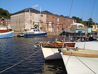
The Exeter Ship Canal, also known as the Exeter Canal is a canal leading from the River Exe to Exeter Quay in the city of Exeter, Devon, England. It was first constructed in the 1560s, predating the "canal mania" period, and is one of the oldest artificial waterways in the UK.

Radcliffe is a market town in the Metropolitan Borough of Bury, Greater Manchester, England. It lies in the Irwell Valley 7 miles (11 km) northwest of Manchester and 3 miles (5 km) southwest of Bury and is contiguous with Whitefield to the south. The disused Manchester Bolton & Bury Canal bisects the town.

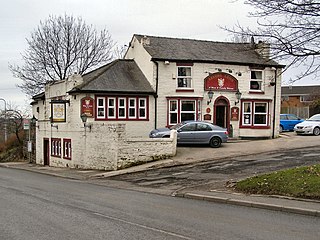
Little Lever is a village in the Metropolitan Borough of Bolton, Greater Manchester, England. Within the Historic County of Lancashire, it is 2 miles (3.2 km) southeast of Bolton, 2 miles (3.2 km) west of Radcliffe and 4 miles (6.4 km) southwest of Bury. In the 19th century, the population was employed in cotton mills, paper mills, bleach works, terracotta works, a rope works and numerous collieries.

The Thames Path is a National Trail following the River Thames from one of its sources near Kemble in Gloucestershire to the Woolwich foot tunnel, south east London. It is about 185 miles (298 km) long. A path was first proposed in 1948 but it only opened in 1996.
Darcy Lever is an area of the Metropolitan Borough of Bolton in Greater Manchester, England. Historically part of Lancashire, the area lies on the B6209, between Bolton and Little Lever. Its history dates to the time of William the Conqueror when it was part of the Salford Hundred given to Roger of Poitou for his participation in the Norman conquest of England.

The River Calder is a major tributary of the River Ribble in Lancashire, England, and is around 20 miles (32 km) in length.

Wet Earth Colliery was a coal mine located on the Manchester Coalfield, in Clifton, Greater Manchester. The colliery site is now the location of Clifton Country Park. The colliery has a unique place in British coal mining history; apart from being one of the earliest pits in the country, it is the place where engineer James Brindley made water run uphill.

The Manchester and Salford Junction Canal was a canal in the city of Manchester. It was originally built to provide a direct waterway between the Mersey and Irwell Navigation and the Rochdale Canal. The canal opened in 1839 and was abandoned in 1922.

The Victoria Arches are a series of bricked-up arches built in an embankment of the River Irwell in Manchester. They served as business premises, landing stages for steam packet riverboats and as Second World War air-raid shelters. They were accessed from wooden staircases that descended from Victoria Street.

Fletcher's Canal was a 1.5-mile (2.4 km) long canal in Greater Manchester, which connected the Wet Earth Colliery to the Manchester, Bolton & Bury Canal at Clifton Aqueduct. The canal is now derelict and no longer used.

Moses Gate Country Park, part of which is also known as Crompton Lodges, is a 750 acre site situated at Moses Gate in the Croal and Irwell Valleys 3 miles (4.8 km) south of Bolton town centre on the A6053 road which connects Farnworth to Little Lever. It is a Local Nature Reserve.

Ladyshore Colliery, originally named Back o' th Barn, was situated on the Irwell Valley fault on the Manchester Coalfield in Little Lever, then in the historic county of Lancashire, England. Founded by Thomas Fletcher Senior, the colliery opened in the 1830s and mined several types of coal. It became infamous as a result of the owners' stand against the use of safety lamps in the mines. Women and children worked in the mines, under poor conditions.

The Irwell Valley in North West England extends from the Forest of Rossendale through the cities of Salford and Manchester. The River Irwell runs through the valley, along with the River Croal.

The Runcorn to Latchford Canal was a man-made canal that ran from Runcorn, to the Latchford area of Warrington. It connected the Mersey and Irwell Navigation to the River Mersey at Runcorn.
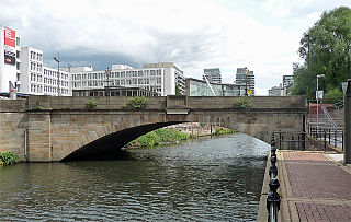
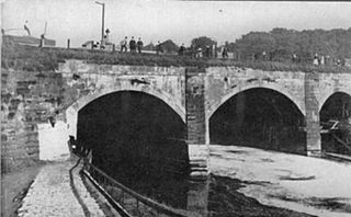
Albert Bridge is a Grade II listed skew arch bridge in Greater Manchester, England. A replacement for an earlier structure, New Bailey Bridge, it was completed in 1844. It crosses the River Irwell, connecting Salford to Manchester.
The Barton Aqueduct, opened on 17 July 1761, carried the Bridgewater Canal over the River Irwell at Barton-upon-Irwell, in the historic county of Lancashire, England. Designed largely by James Brindley under the direction of John Gilbert, it was the first navigable aqueduct to be built in England, "one of the seven wonders of the canal age" according to industrial archaeologist Mike Nevell.

Moston Brook is a stream in Greater Manchester in north-west England and a tributary of the River Irk. The brook is formed at the confluence of Bower Brook and Hole Bottom Brook. This occurs near the Rochdale Canal in Failsworth in the Metropolitan Borough of Oldham. It flows southwest, forming the border between Moston, Manchester and Failsworth before being culverted almost all of the remaining route to its meeting the River Irk. It has a total length of about 3.7 miles.
53°33′13″N2°21′39″W / 53.553651°N 2.360789°W
| | This Greater Manchester location article is a stub. You can help Wikipedia by expanding it. |
| | This industry-related article is a stub. You can help Wikipedia by expanding it. |