Irwell Valley

Last updated

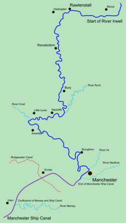
The Irwell Valley in North West England extends from the Forest of Rossendale through the cities of Salford and Manchester. The River Irwell runs through the valley, along with the River Croal.

Contents

Course of the Irwell Map of River irwell.png
Course of the Irwell

Geology

A tributary of the Irwell flowing over the New Red Sandstone at Clifton Red sandstone on the Irwell.jpg
A tributary of the Irwell flowing over the New Red Sandstone at Clifton

Shallow seas covered most of south-east Lancashire in the Upper Carboniferous period when deposits of mud and sand were laid down. These later became beds of shales and sandstones alternating with layers of gritstone. There are also beds of New Red Sandstone and Manchester Marls. [1] The glaciers of the Pleistocene epoch further shaped the landscape and then retreated, leaving behind deposits of sand, pebbles and boulder clay that formed the fluvioglacial ridges of the Irwell Valley. [2] Ashclough, a 5.8 hectare (14.3 acre) site which comprises the steep banks of the river between Prestolee and Little Lever, has been designated a Site of Special Scientific Interest (SSSI) because of its geological interest, primarily because it is the best site in the area displaying Ashcough Marine Band and its associated strata. Ashclough is a site of national importance for interpreting the coal measure paleogeography of Great Britain. [3]

Industrial history

Ladyshore Colliery Ladyshore Waterson.JPG
Ladyshore Colliery

During the Industrial Revolution factories, mills and terraced hovels grew up along the river banks and the region became filled with cotton mills, coal mines, print works, bleach works, dye works, chemical works, paper works, in fact almost every kind of industry. [4] Wet Earth Colliery was located in the valley at Clifton, along with a number of bleach and dye works including Lever Bank Bleach Works. A number of canals were built to transport goods through the valley, the largest of which is the Manchester Ship Canal. Although many of the smaller canals were abandoned with the coming of the railways, isolated sections of the Manchester Bolton & Bury Canal still remain, and there are plans to restore it for leisure purposes.

The waste from the industries along the Irwell polluted the river so heavily that by the 1850 it was virtually devoid of wildlife, however, since the late 19th century many attempts have made to improve the quality of the water. In 1891 the Mersey and Irwell Joint Committee was formed. This body ordered local authorities to provide sewage treatment facilities, and industrial concerns were told to use the best practical means of preventing pollution. In 1939 this body was superseded by the Lancashire Rivers Board, but wartime conditions brought about further deterioration of the river. In 1951 the Rivers (Prevention of Pollution) Act was passed and this board disappeared to be replaced by the Mersey River Board, which was replaced in turn by the Mersey and Weaver River Authority in 1965. In 1974 all the river authorities were merged into the Regional Water Authorities. [5] Since then there has been a gradual improvement in water quality, [6] and today wildlife is returning to the Irwell.

Local wildlife

Some industrial waste products, such as spoil from mining, or alkaloids from other industrial processes were disposed of locally. Caustic waste from the Leblanc process was dumped on at least two sites - Nob End, to the south of Bolton and Lower Hinds in Bury. The waste on both sites has since weathered-down to calcium carbonate and has provided an ideal environment for a number of nationally rare calcicolous plants, unique in what is predominately an area of acidic soil. These plants, along with non-indigenous garden escapees such as giant hogweed and Himalayan balsam, have added much variety to the flora of the valley. Nob End was designated as a Site of Special Scientific Interest in 1988 and a Local Nature Reserve in 2000. [7] [8]

The M60 passes through the valley and the bridge at junction 16 (A666) in Clifton is used as a summer roost for over 100 Daubenton's bats. [9]

Irwell Sculpture Trail

The Irwell Sculpture Trail is one of the largest public art initiatives and the longest sculpture trail in the UK. [10] The trail consists of a scenically varied, 30-mile (48 km) walking route based on the well-established Irwell Valley Trail stretching from Salford Quays to the moors above Bacup. Since 1987 over 30 pieces of public art have been commissioned from regional, national and international artists. [11]

Related Research Articles

Manchester Bolton & Bury Canal Canal in Greater Manchester, England

The Manchester Bolton & Bury Canal is a disused canal in Greater Manchester, England, built to link Bolton and Bury with Manchester. The canal, when fully opened, was 15 miles 1 furlong (24 km) long. It was accessed via a junction with the River Irwell in Salford. Seventeen locks were required to climb to the summit as it passed through Pendleton, heading northwest to Prestolee before it split northwest to Bolton and northeast to Bury. Between Bolton and Bury the canal was level and required no locks. Six aqueducts were built to allow the canal to cross the rivers Irwell and Tonge and several minor roads.

Salford City of Greater Manchester, England

Salford is a city and the core settlement of the wider City of Salford metropolitan borough in Greater Manchester, England. In 2011, Salford had a population of 103,886. It is also the second and only other city in the county after neighbouring Manchester. Salford is located in a meander of the River Irwell which forms part of its boundary with Manchester. The former County Borough of Salford, which also included Broughton, Pendleton and Kersal, was granted city status in 1926. In 1974 the wider Metropolitan Borough of the City of Salford was established with responsibility for a significantly larger region.

Manchester Ship Canal UK canal linking Manchester to the coast

The Manchester Ship Canal is a 36-mile-long (58 km) inland waterway in the North West of England linking Manchester to the Irish Sea. Starting at the Mersey Estuary near Liverpool, it generally follows the original routes of the rivers Mersey and Irwell through the historic counties of Cheshire and Lancashire. Several sets of locks lift vessels about 60 feet (18 m) to the canal's terminus in Manchester. Landmarks along its route include the Barton Swing Aqueduct, the world's only swing aqueduct, and Trafford Park, the world's first planned industrial estate and still the largest in Europe.

Bridgewater Canal Canal in northwest England

The Bridgewater Canal connects Runcorn, Manchester and Leigh, in North West England. It was commissioned by Francis Egerton, 3rd Duke of Bridgewater, to transport coal from his mines in Worsley to Manchester. It was opened in 1761 from Worsley to Manchester, and later extended from Manchester to Runcorn, and then from Worsley to Leigh.

Sankey Canal Canal in England

The Sankey Canal in North West England, initially known as the Sankey Brook Navigation and later the St Helens Canal, is a former industrial canal, which when opened in 1757 was England's first of the Industrial revolution, and the first modern canal.

River Irwell River in Lancashire, United Kingdom

The River Irwell is a tributary of the River Mersey in north west England. It rises at Irwell Springs on Deerplay Moor, approximately 1+12 miles north of Bacup and flows southwards for 39 mi (63 km) to meet the Mersey near Irlam. The Irwell marks the boundary between Manchester and Salford, and its lower reaches have been canalised and now form part of the Manchester Ship Canal.

Irwell Sculpture Trail Public art trail in England

The Irwell Sculpture Trail is the largest public art scheme in England, commissioning regional, national and international artists. The Trail includes 28 art pieces and follows a well established 30-mile (48 km) footpath stretching from Salford Quays through Bury into Rossendale and up to the Pennines above Bacup.

Radcliffe, Greater Manchester Town in Greater Manchester, England

Radcliffe is a market town in the Metropolitan Borough of Bury, Greater Manchester, England. It lies in the Irwell Valley 6.5 miles (10 km) north-northwest of Manchester and 2.5 miles (4 km) south-west of Bury and is contiguous with Whitefield to the south. The disused Manchester Bolton & Bury Canal bisects the town.

Pendlebury Human settlement in England

Pendlebury is a town in the City of Salford, Greater Manchester, England. The population at the 2011 Census was 13,069. It lies 4.1 miles (6.6 km) northwest of Manchester city centre, 3.4 miles (5.5 km) northwest of Salford, and 5.9 miles (9.5 km) southeast of Bolton.

Clifton, Greater Manchester Human settlement in England

Clifton is a suburb of Swinton in the City of Salford in Greater Manchester, England. It lies along the edge of Irwell Valley in the north of the City of Salford. Historically in Lancashire, it was a centre for coal mining, and once formed part of the Municipal Borough of Swinton and Pendlebury.

Barton upon Irwell Suburb of the City of Salford, England

Barton upon Irwell is a suburban area of the City of Salford, Greater Manchester, England, with a population of 12,462 in 2014.

Wet Earth Colliery Historical industrial site in England

Wet Earth Colliery was a coal mine located on the Manchester Coalfield, in Clifton, Greater Manchester. The colliery site is now the location of Clifton Country Park. The colliery has a unique place in British coal mining history; apart from being one of the earliest pits in the country, it is the place where engineer James Brindley made water run uphill.

Nob End

Nob End is the site of a former waste tip which is now a Site of Special Scientific Interest and Local Nature Reserve near Little Lever and Kearsley, in Greater Manchester, England.

Kersal Moor Mountain in the United Kingdom

Kersal Moor is a recreation area in Kersal, Greater Manchester, England which consists of eight hectares of moorland bounded by Moor Lane, Heathlands Road, St. Paul's Churchyard and Singleton Brook.

Clifton Country Park

Clifton Country Park is a local nature reserve in the Irwell Valley at Clifton, Greater Manchester, North West England. Situated next to a double bend in the River Irwell, it is north east of the Manchester to Preston railway line and the A666, Manchester Road, Clifton where it is accessible via Clifton House Road opposite Clifton Cricket Club. Junction 16 of the M60 motorway is only about ¼ mile away to the south east.

Drinkwater Park

Drinkwater Park is situated in the Irwell Valley on the western border of Prestwich, near Manchester, bounded by the River Irwell to the west, Agecroft Road and Rainsough Brow (A6044) to the south, Butterstile Lane and Carr Clough estate to the east and Bunkers Hill to the north. The park is administered by Forestry England and is part of Prestwich Forest Park, which also incorporates Philips Park, Mere Clough, Prestwich Clough, Forest Bank Park in Pendlebury and Waterdale Meadow.

Moses Gate Country Park

Moses Gate Country Park, part of which is also known as Crompton Lodges, is a 750 acre site situated at Moses Gate in the Croal and Irwell Valleys 3 miles south of Bolton town centre on the A6053 road which connects Farnworth to Little Lever. It is a Local Nature Reserve.

Manchester Racecourse

Manchester Racecourse was a venue for horse racing located at a number of sites around the Manchester area including; Kersal Moor, New Barnes, Weaste and Castle Irwell, Pendleton, then in Lancashire. The final home of the course, Castle Irwell, was closed in 1963. Despite its name, the course was never actually located within the boundaries of the ancient township of Manchester or the subsequent city of Manchester.

Mark Addy (oarsman) Recipient of the Albert Medal

Mark Anthony Addy AM was a publican and champion oarsman, from Manchester, England, who was awarded the Albert Medal (AM), and a number of other honours, for the rescue of over 50 people from the then highly polluted River Irwell in the 19th century. The Albert Medal was later superseded by the George Cross as the highest civilian or non-combat gallantry award in the British honours system.

Peel Park, Salford Urban park

Peel Park is a public urban park in Salford, Greater Manchester, England, located on the flood plain of the River Irwell below Salford Crescent and adjacent to the University of Salford. It was the first of three public parks to be opened on 22 August 1846, for the people of Manchester and Salford, paid for by public subscription. The park was the main public venue for the 1851 royal visit of Queen Victoria to Manchester and Salford and has been the subject of a number of paintings by the Salford artist, L.S. Lowry.

References

  1. Bracegirdle pp 15,16
  2. Hindle, P.(1998) (21 August 2003). "Exploring Greater Manchester - a fieldwork guide: The fluvioglacial gravel ridges of Salford and flooding on the River Irwell" (PDF). Manchester Geographical Society. Retrieved 11 December 2007.
  3. "Ashclough citation sheet" (PDF). English Nature. Retrieved 24 February 2007.
  4. Bracegirdle pp.19
  5. Bracegirdle pp. 153–155
  6. APEM Aquatic Scientists (October 2004). "Urban Regeneration in Manchester: Transforming the "Dark River Irwell"" (PDF). Mersey Basin Campaign. Environment Agency. p. 5. Retrieved 4 April 2015.
  7. Anon. "File SD 70/2: Nob End" (PDF). Retrieved 18 February 2012.
  8. Richardson, Derek. "Grasslands" (PDF). Habitat Action Plan 2009. Greater Manchester Biodiversity Project. Retrieved 18 February 2012.
  9. Anon. "M60 Irwell Valley Bridgeworks". Highways Agency. Archived from the original on 3 July 2008. Retrieved 29 May 2008.
  10. Anon (2008). "Irwell Sculpture Trail". Lancashire County Council website. Lancashire County Council. Archived from the original (http) on 13 June 2011. Retrieved 17 May 2008.
  11. Morland, Joanna (2000). "Case Study: Irwell Sculpture Trail". Public art online. Public Art Southwest. Archived from the original (http) on 4 May 2008. Retrieved 17 May 2008.

Coordinates: 53°40′N2°19′W / 53.66°N 2.31°W / 53.66; -2.31